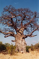
Ghana is a West African country in Africa, along the Gulf of Guinea.

The Gur languages, also known as Central Gur or Mabia, belong to the Niger–Congo languages. They are spoken in the Sahelian and savanna regions of West Africa, namely: in most areas of Burkina Faso, and in south-central Mali, northeastern Ivory Coast, the northern halves of Ghana and Togo, northwestern Benin, and southwestern Niger. A few Gur languages are spoken in Nigeria. Additionally, a single Gur language, Baatonum, is spoken in Benin and in the extreme northwest of Nigeria. Three other single Gur languages, the Tusya, Vyemo and Tiefo languages, are spoken in Burkina Faso. Another unclassified Gur language, Miyobe, is spoken in Benin and Togo. In addition, Kulango, Loma and Lorhon, are spoken in Ghana, Ivory Coast and Burkina Faso. Additionally, a few Mossi speakers are in Senegal, and speakers of the Dagaare language are also found in Cameroon. The Samu languages of Burkina Faso are Gur languages.

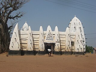
Tamale is the capital city of the Northern Region of Ghana. It is Ghana's third largest city, with a population of 950,000. The city has been ranked as the fastest-growing city in West Africa. It is located 600 km (370 mi) north of Accra.

The Dagbamba or Dagomba are an ethnic group of Ghana, and Togo. They number more than 3.1 million people. The term Dagbamba is originally extended to refer to other related peoples who were unified by Naa Gbewaa including the Mamprusi and Nanumba. The Dagomba country is called Dagbon and they speak Dagbanli language. Dagbanli is the most spoken language of northern Ghana and second most widely spoken local language of Ghana. Dagbanli belongs to the Mabia (Mole-Dagbani) subgroup of the Gur languages, a large group of related languages in West Africa. The Dagomba practises both patrilineal and matrilineal systems of inheritance.

Yendi , is the traditional capital of the Kingdom of Dagbon and the administrative centre of the Yendi Municipal District in the Northern Region of Ghana. As of 2021, the population of Yendi was 154,421 comprising 76,142 males and 78,279 females. It is the seat of the King of the Dagbon, Ghana's oldest kingdom.

Volta Region is one of Ghana's sixteen administrative regions, with Ho designated as its capital. It is located west of Republic of Togo and to the east of Lake Volta. Divided into 25 administrative districts, the region is multi-ethnic and multilingual, including groups such as the Ewe, the Guan, and the Akan peoples. The Guan peoples include the Lolobi, Likpe, Akpafu, Buem,Nyangbo,Avatime, and Nkonya. This region was carved out of the Volta Region in December 2018 by the New Patriotic Party. The people of the Volta Region are popularly known as Ewes. The people of the Volta Region are popular known for their rich cultural display and music some of which include Agbadza, Borborbor and Zigi.

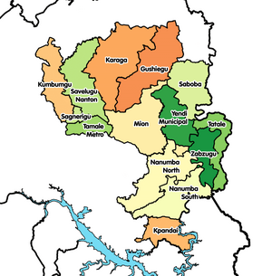
Gushegu Municipal District is one of the sixteen districts in Northern Region, Ghana. Originally it was formerly part of the then-larger Gushegu-Karaga District in 1988, which was created from the former East Dagomba District Council, until the western part of the district was split off to create Karaga District on 27 August 2004; thus the remaining part has been renamed as Gushegu District, which it was later elevated to municipal district assembly status on that same year to become Gushegu Municipal District. The municipality is located in the northeast part of Northern Region and has Gushegu as its capital town.

The railway stations in Ghana serve a rail network concentrated in the south of the country.
The Guan or Guang people are an ethnic group found almost in all parts of Ghana, including the Akyode people who speak Gikyode,Krachi people, language-Kaakye people Nkonya tribe, the Gonja, Anum, Larteh, Akposo, Maghan people, Nawuri,Nyagbo and Ntsumburu. The Guan are believed to have been the first settlers in modern day southern Ghana, migrating from the Mossi-Dagbon region of modern Ghana and Burkina around 1000 A.D. The Gonja of the Guan are however late settlers in northern Ghana, invading eastern Dagbon in the 1600s, capturing Daboya and many towns including the Maghan provinces of western and southern Dagbon.
The Mampruli language is a Gur language spoken in northern Ghana, Northern Togo, Burkina Faso, Ivory Coast and Mali by the Mamprusi people. It is partially mutually intelligible with Dagbani. The Mamprusi language is spoken in a broad belt across the northern parts of the Northern Region of Ghana, stretching west to east from Yizeesi to Nakpanduri and centred on the towns of Gambaga, Nalerigu and Walewale.
Bimbilla is the capital town of Nanumba North District, a district in the Northern Region of Ghana. It is located in the East of the region, and is near the Oti River. The location is situated within the range of 8.5° north to 9.25° north latitude, and between 0.57° east to 0.5° east longitude. It borders five municipalities: Yendi Municipal to the north, Mion Municipal to the northwest, East Gonja Municipal to the west and southwest, Nanumba South Municipal to the south and east, and Zabzugu Municipal to the north-northeast.

The Kingdom of Dagbon (Dagbaŋ) is the oldest and one of the most organised traditional kingdoms in Ghana founded by the Dagomba people (Dagbamba) in the 15th century. During its rise, it comprised, at various points, the Northern, Upper West, Upper East, Savannah Region and North East regions of present-day Ghana. It also covered portions of Burkina Faso, North East Ivory Coast and North West Togo. Since Ghana's independence in 1957, the Kingdom just like all of Ghana's kingdoms and ethnic states has assumed a traditional, customary role.
Mion District is one of the sixteen districts in Northern Region, Ghana. Originally it was formerly part of the then-larger Yendi District in 1988, which was created from the former East Dagomba District Council, until the western part of the district was later split off to create Mion District on 28 June 2012; thus the remaining original part has bee retained to become Yendi Municipal District. The district assembly is located in the central part of Northern Region and has Sang as its capital town.
Duko is a village in the Savelugu municipal district of Ghana. In 2015 it had population of about 900 inhabitants.
The N2 or National Highway 2 is a national highway in Ghana that begins at the Tema Motorway interchange at Tema and runs through Hohoe, Nkwanta, Yendi, and Bawku to the border with Burkina Faso at Kulungugu. It is the main north-south highway in the eastern corridor of the country, with a total distance of 640 kilometres (400 mi). The route runs through the Greater Accra, Eastern, Volta, Oti, Northern, North East Region and Upper East regions of Ghana.
The Oti Region is one of the six newly created regions of Ghana in December 2018. The region was carved out of the northern part of the Volta Region and will be in fulfillment of a campaign promise made by New Patriotic Party. Prior to the 2016 Ghanaian general election, the then candidate Nana Akufo-Addo declared that when elected, he would explore the possibility of creating new regions out of some of the existing regions in Ghana in order to bring government closer to citizens. The Region was inaugurated on May 14, 2019. It has Dambai as its Regional Capital. The people of Oti region have for more than 60 years always wanted to have a region of their own before its creation in 2018 by the President Nana Addo Dankwa Akufo-Addo led government in December 2018.
The Savannah Region is one of the newest regions of Ghana and yet the largest region in the country. The creation of the Region follows presentation of a petition by the Gonja Traditional Council, led by the Yagbonwura Tumtumba Boresa Jakpa I. Upon receiving favourable responses from all stakeholders in the Northern Region, the Brobbey Commission, a referendum was conducted on the 27th December 2018. The result was a resounding yes of 99.7%. The President of the Republic of Ghana signed and presented the Constitutional Instrument (CI) 115 to the Yagbonwura in the Jubilee House, Accra on 12 February 2019. The launch was well attended by sons and daughters of Gonjaland including all current and past Mps, MDCEs and all appointees with Gonjaland descent. Damongo was declared the capital of the new Savannah Region. It is located in the north of the country. The Savannah Region is divided into 7 districts; Bole, Central Gonja, North Gonja, East Gonja, Sawla/Tuna/Kalba, West Gonja, North East Gonja and 7 Constituencies; Bole/Bamboi, Damongo, Daboya/Mankarigu, Salaga North, Salaga South, Sawla/Tuna/Kalba and Yapei/Kusawgu. The capital of Bole district is Bole; East Gonja municipal is Salaga; West Gonja district is Damango; Sawla Tuna Kalba district is Salwa; Central Gonja is Buipe; North Gonja is Daboya; and North East Gonja is Kpalbe
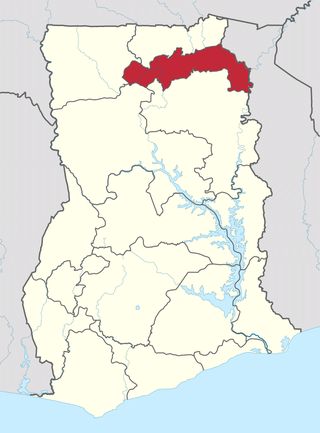
The North East Region is one of the sixteen regions of Ghana. It is located in the north of the country and was created in December 2018 after a referendum was voted upon to break it off of the Northern region. The region's capital is Nalerigu.
Sang is a town in the Northern Region of north Ghana. The Mion District is one of the new districts created in 2018 in Ghana. It used to be part of the Yendi Municipal District. It is the capital of the Mion District. The largest town to the west is Tamale and to the east is Yendi.