Politics
Northwestern Ontarians tend to lean left politically, mainly due to the history and influence of labour unions and a growing environmental ethic. At the federal level, Northwestern Ontario is represented by Liberal MPs Marcus Powlowski in Thunder Bay—Rainy River and Patty Hajdu in Thunder Bay—Superior North, as well as Conservative MP Eric Melillo in the Kenora District,. Provincially, PC Greg Rickford represents Kenora—Rainy River, NDP Sol Mamakwa represents Kiiwetinoong, PC Ken Holland represents Thunder Bay—Atikokan, and Liberal Michael Gravelle represents Thunder Bay—Superior North.
In 2005, some residents of the region expressed dissatisfaction at the level of attention paid to the region by the provincial government. Some, most notably former Kenora mayor Dave Canfield, [2] and Fort Frances town councillor Tannis Drysdale, have proposed the idea of the region as a whole, or parts of it, seceding from Ontario to join Manitoba, although the campaign did not attract widespread public support. [3]
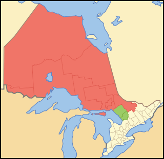
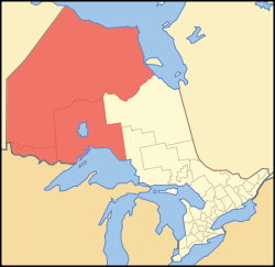
Northern Ontario is a primary geographic and quasi-administrative region of the Canadian province of Ontario, the other primary region being Southern Ontario. Most of the core geographic region is located on part of the Superior Geological Province of the Canadian Shield, a vast rocky plateau located mainly north of Lake Huron, the French River, Lake Nipissing, and the Mattawa River. The statistical region extends south of the Mattawa River to include all of the District of Nipissing. The southern section of this district lies on part of the Grenville Geological Province of the Shield which occupies the transitional area between Northern and Southern Ontario. The extended federal and provincial quasi-administrative regions of Northern Ontario have their own boundaries even further south in the transitional area that vary according to their respective government policies and requirements. Ontario government departments and agencies such as the Growth Plan for Northern Ontario and the Northern Ontario Heritage Fund Corporation define Northern Ontario as all areas north of, and including, the districts of Parry Sound and Nipissing for political purposes, and the federal but not the provincial government also includes the district of Muskoka.
Thunder Bay is a city on Lake Superior in the province of Ontario, Canada.

Kenora District is a district and census division in Northwestern Ontario, Canada. The district seat is the City of Kenora.

Thunder Bay District is a district and census division in Northwestern Ontario in the Canadian province of Ontario. The district seat is Thunder Bay.
King's Highway 17, more commonly known as Highway 17, is a provincially maintained highway and the primary route of the Trans-Canada Highway through the Canadian province of Ontario. It begins at the Manitoba boundary, 50 km (31 mi) west of Kenora, and the main section ends where Highway 417 begins just west of Arnprior. A small disconnected signed section of the highway still remains within the Ottawa Region between County Road 29 and Grants Side Road. This makes it Ontario's longest highway.
The Winnipeg River is a Canadian river that flows roughly northwest from Lake of the Woods in the province of Ontario to Lake Winnipeg in Manitoba. This river is 235 kilometres (146 mi) long from the Norman Dam in Kenora to its mouth at Lake Winnipeg. Its watershed is 106,500 square kilometres (41,100 sq mi) in area, mainly in Canada. About 29,000 square kilometres (11,000 sq mi) of the watershed is in northern Minnesota, United States.

Fort Frances is a town in, and the seat of, Rainy River District in Northwestern Ontario, Canada. The population as of the 2021 census was 7,466 Fort Frances is a popular fishing destination. It hosts the annual Fort Frances Canadian Bass Championship.

Kenora is a federal electoral district in Ontario, Canada, that has been represented in the House of Commons of Canada since 2004.

Thunder Bay—Rainy River is a federal electoral district in Ontario, Canada, that has been represented in the House of Commons of Canada since 2004. It first elected a member in the 2004 federal election.
Fort William was a federal electoral district represented in the House of Commons of Canada from the year 1925 to 1979. It was located in the province of Ontario. This riding was created in 1924 from parts of Fort William and Rainy River riding.
Kenora—Rainy River was a federal electoral district represented in the House of Commons of Canada from 1925 to 2004. It was located in the province of Ontario. This riding was created in 1924 from parts of Fort William and Rainy River and Port Arthur and Kenora ridings.
Thunder Bay was an electoral district in the northwestern part of the province of Ontario, Canada, that was represented in the House of Commons of Canada from 1968 to 1979, and the Legislative Assembly of Ontario until 1975.
Thunder Bay—Atikokan was a federal electoral district in northwestern Ontario, Canada, that was represented in the House of Commons of Canada from 1979 to 2003 and in the Legislative Assembly of Ontario from 1999 to 2007. The federal riding was created in 1976, from parts of Fort William and Thunder Bay ridings. It became a provincial riding in 1999.
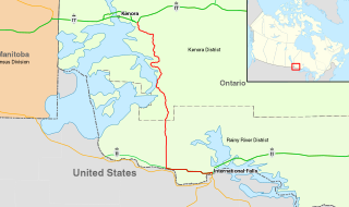
King's Highway 71, commonly referred to as Highway 71, is a provincially maintained highway in the Canadian province of Ontario. The 194-kilometre-long (121 mi) route begins at the Fort Frances–International Falls International Bridge in Fort Frances, continuing from US Highway 53 (US 53) and US 71 in Minnesota, and travels west concurrently with Highway 11 for 40 kilometres (25 mi) to Chapple. At that point, Highway 11 continues west while Highway 71 branches north and travels 154 kilometres (96 mi) to a junction with Highway 17 just east of Kenora. Highway 71 forms a branch of the Trans-Canada Highway for its entire length, with the exception of the extremely short segment south of Highway 11 in Fort Frances.
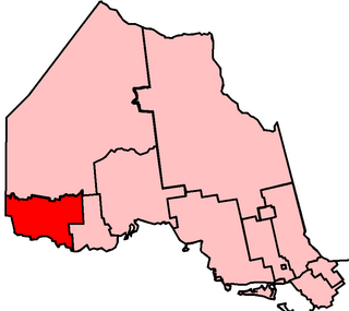
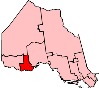
Kenora—Rainy River is a provincial electoral district (riding) in northwestern Ontario, Canada, that has been represented in the Legislative Assembly of Ontario since 1999. It was created from Kenora, most of Rainy River and part of Lake Nipigon. The boundaries of the new district corresponded with the Kenora—Rainy River federal riding, until it was abolished in 2003. The provincial riding will continue to exist.
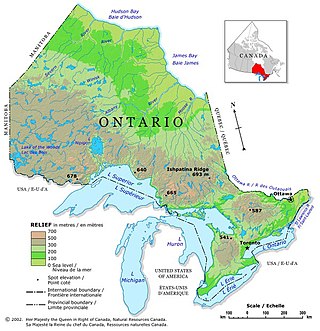
Ontario is located in East/Central Canada. It is Canada's second largest province by land area. Its physical features vary greatly from the Mixedwood Plains in the southeast to the boreal forests and tundra in the north. Ontario borders Manitoba to the west, Hudson Bay and James Bay to the north, Quebec to the east, and the Great Lakes and the United States to the south. The province is named for Great Lake Ontario, an adaptation of the Iroquois word Onitariio, meaning "beautiful lake", or Kanadario, variously translated as "beautiful water". There are approximately 250,000 lakes and over 100,000 kilometres (62,000 mi) of rivers in the province.
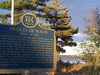
Jacques de Noyon was a French Canadian explorer and coureur des bois. He is the first known European to visit the Boundary Waters region west of Lake Superior.
Thunder Bay—Atikokan is a provincial electoral district in northwestern Ontario, Canada, that has been represented in the Legislative Assembly of Ontario since 1999.
Sarah Jane Campbell is a politician in Ontario, Canada. She was a New Democratic member of the Legislative Assembly of Ontario who represented the riding of Kenora—Rainy River from 2011 to 2018.