Eaton Hall is the country house of the Duke of Westminster. It is 1 mile (2 km) south of the village of Eccleston, in Cheshire, England. The house is surrounded by its own formal gardens, parkland, farmland and woodland. The estate covers about 10,872 acres (4,400 ha).

Morden is a civil parish in the Purbeck district of south Dorset, England. Morden is about 6 miles (10 km) north-west of Poole. At the 2011 census the civil parish had 141 households and a population of 323.

Ashwell is a village and civil parish in Hertfordshire situated 4 miles (6 km) north-east of Baldock.

Guilden Morden, England, is a village and parish located in Cambridgeshire about 16 miles (26 km) south west of Cambridge and 9 miles (14 km) west of Royston in Hertfordshire. It is served by the main line Ashwell and Morden railway station 3 miles (5 km) to the south in the neighbouring parish of Steeple Morden.

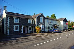
Ashwell & Morden railway station is a wayside railway station in Cambridgeshire, England. Close to the border with the county of Hertfordshire, it is in the hamlet of Odsey, slightly north of the Icknield Way, a Roman Road that is now the A505. It is 41 miles (65.98 km) down the line from London King's Cross. Train services are currently operated by Thameslink.
Newton Surmaville is a 15,129-square-foot (1,405.5 m2) stately home with gardens and a park south of Yeovil, Somerset in the district of South Somerset, in England. It lies just outside the town in the parish of Barwick.

Creech Grange is a country house in Steeple, south of Wareham in Dorset at the foot of the Purbeck Hills. Historic England designate it as a Grade I listed building. The park and gardens are Grade II* listed in the National Register of Historic Parks and Gardens.

Stanton Harcourt is a village and civil parish in Oxfordshire about 4 miles (6.4 km) southeast of Witney and about 6 miles (10 km) west of Oxford. The parish includes the hamlet of Sutton, 1⁄2 mile (800 m) north of the village. The 2011 Census recorded the parish's population as 960.

Steeple Morden is a village and civil parish in Cambridgeshire, England, about 15 miles (24 km) south west of Cambridge and 5 miles (8 km) west of Royston. It is part of the South Cambridgeshire local government district.
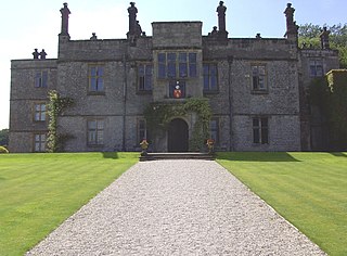
Tissington Hall is an early 17th-century Jacobean mansion house in Tissington, near Ashbourne, Derbyshire. It is a Grade II* listed building.
Sir Herbert George Fordham, was a British writer on cartography whose Carto-Bibliography method of cataloging maps was widely adopted. He was the benefactor of the Fordham collection housed by the Royal Geographical Society - one of the most important map collections in the country.

Ven House in Milborne Port, Somerset, England is an English manor house that has been designated as a Grade I listed building.
Twemlow Hall is a country house standing on a former moated site in the parish of Twemlow, Cheshire, England. It dates from the 17th century, and was "much altered" in 1810 for William Bache Booth. It was altered again in 1974. The house is constructed in brick on a stone plinth. It has flush stone quoins and a slate roof. It has two storeys, and a symmetrical entrance front of five bays, three of which are gabled. Above the doorway are the arms of the Booth family. The windows are sashes. The house is recorded in the National Heritage List for England as a designated Grade II listed building. Three structures associated with the hall forming three sides of a former stable yard are also listed at Grade II.
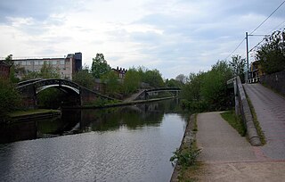
The Icknield Port Loop is a 0.6-mile (1 km) loop of the eighteenth-century-built Old BCN Main Line canal in Birmingham, England, about 2 miles (3 km) west of the city centre, which opened to traffic on 6 November 1769 and in some definitions includes its straighter bypass built in September 1827, a 550-yard (500 m) section of the New BCN Main Line. Most of the 56 acres (23 ha) of land thereby enclosed is derelict meaning the canal serves the Canal & River Trust maintenance depot at Icknield Port and conveys water from Edgbaston Reservoir to the BCN Main Line. The enclosed land has no pedestrian or vehicular access. Icknield Port (Loop) takes its name from the Roman Icknield Street which passed nearby, the exact route of which is unknown.
Bampton is a civil parish in the Eden District, Cumbria, England. It contains 35 buildings that are recorded in the National Heritage List for England. Of these, two are listed at Grade II*, the middle grade of the three grades, and the others are at Grade II, the lowest grade. The parish contains the villages of Bampton and Bampton Grange and smaller settlements, but is mainly rural. Most of the listed buildings are houses and associated structures, farmhouses and farm buildings in the villages and scattered around the countryside. The other listed buildings include a former boundary cross, a church, a monument in the churchyard, two bridges, a public house, and a limekiln.

The Guilden Morden boar is a sixth- or seventh-century Anglo-Saxon copper alloy figure of a boar that may have once served as the crest of a helmet. It was found around 1864 or 1865 in a grave in Guilden Morden, a village in the eastern English county of Cambridgeshire. There the boar attended a skeleton with other objects, including a small earthenware bead with an incised pattern, although the boar is all that now remains. Herbert George Fordham, whose father originally discovered the boar, donated it to the British Museum in 1904; as of 2018 it was on view in room 41.
Middleton and Smerrill is a civil parish in the Derbyshire Dales district of Derbyshire, England. The parish contains 31 listed buildings that are recorded in the National Heritage List for England. All the listed buildings are designated at Grade II, the lowest of the three grades, which is applied to "buildings of national importance and special interest". The parish contains the village of Middleton-by-Youlgreave and the surrounding countryside. Most of the listed buildings are houses, cottages and associated structures, farmhouses and farm buildings. The other listed buildings include a church, a former chapel with a tomb in its grounds, a smithy, a former public house, a drinking fountain and a telephone kiosk.
Wormhill is a civil parish in the High Peak district of Derbyshire, England. The parish contains 26 listed buildings that are recorded in the National Heritage List for England. Of these, three are listed at Grade II*, the middle of the three grades, and the others are at Grade II, the lowest grade. The parish contains the village of Wormhill and the surrounding area. Most of the listed buildings are houses, cottages and associated structures, farmhouses and farm buildings. The other listed buildings include a church and associated structures, a village cross moved into the churchyard, a railway viaduct, and a memorial fountain.
Ordsall is a village in the Bassetlaw District of Nottinghamshire, England, near the market town of Retford. The village contains seven listed buildings that are recorded in the National Heritage List for England. Of these, one is at Grade II*, the middle of the three grades, and the others are at Grade II, the lowest grade. The listed buildings consist of a church, its former rectory, a war memorial in the churchyard, and houses and cottages with associated structures.
Clumber and Hardwick is a civil parish in the Bassetlaw District of Nottinghamshire, England. The parish contains 26 listed buildings that are recorded in the National Heritage List for England. Of these, one is listed at Grade I, the highest of the three grades, six are at Grade II*, the middle grade, and the others are at Grade II, the lowest grade. The parish contains Clumber Park, the grounds of the former Clumber Park House, and the settlement of Hardwick Village. The listed buildings in Clumber Park include the surviving range of the house, the stable range, a stable courtyard and former vicarage, the kitchen gardens and a palm house, a church, a bridge, two temples, a grotto, gateways and lodges. In the village are houses, farm buildings and a war memorial.