Oku, Cameroon

Last updated
Lake Oku, Northwest Province, Cameroon Lake Oku Cameroon.jpg
Lake Oku, Northwest Province, Cameroon
Provinces of Cameroon EN Provinces of Cameroon EN.svg
Provinces of Cameroon EN

Oku is a subdivision in North West Region, (formerly North West Province), Cameroon. The term Oku also refers to the people who live in this region ruled by a Paramount Monarch [HRM King Ngum IV. Ngum Ernest Merlin Shang] and the primary language that they speak (although English is also widely spoken). Oku is a rural area containing about 36 villages with the population of about 180,000 inhabitants . The nearest really large city is Bamenda, but Kumbo, which is closer (about 23 kilometres or 14 miles from the village of Keyon, or about 70 minutes by car, as the road network is not good and not paved), is large enough to have telephone lines and a Baptist-run hospital. Oku also has a Sub-divisional hospital. However, three mobile telephone networks (MTN, ORANGE, CAMTEL) are available in Oku. As such, mobile internet facilities are available.

Contents

Geography and climate

Oku is a very mountainous region, around 1,200 metres (3,900 ft) above sea level, and thus rather cool considering its latitude. It is not cold enough for snow, but at night during the dry season temperatures drop below human comfort range. Mount Oku, a stratovolcano, reaches a height of 3011 metres (9880 feet) and is the second highest mountain of Cameroon after Mount Fako (better known as Mount Cameroon). [1]

The broader Oku or Foumbot volcanic field also includes many scoria cones and maars, several of which are filled by crater lakes. Lake Oku is a crater lake. Two of the crater lakes, Lake Nyos and Lake Monoun, have been the subject of extensive research. Quantities of gas build up in the lakes and are occasionally released; being heavier than air, they pour down the mountainside and can suffocate entire villages. [1] Some of the locals believe that a god lives in the lake and must be appeased.

The region is an important one for biodiversity, especially the Kelum mountain Forest.

Oku has many well graded earth road linking its various villages and neighbouring subdivisions like Noni, Babessi and Kumbo central, although none of them would be called good by most Westerners. Oku has recently got a road link through Babungo from Bamenda. One can now take two hours from Bamenda through Ibal Oku, Mbockevuh, Mawes*lake oku* through Tolon, Chiar, Ikal to Elak and to Banso.

Economy

Oku is characterized by subsistence farming. There is a shortage of arable land, and the people farm even the steep hillsides. A typical practice is to plant beans, corn, and potatoes together in the same furrows.

There is also a lot of bee farming in Oku, and Oku is the only area in the whole of Cameroon that produces the natural white honey. The Oku Honey Cooperative manage and sell what bee farmers harvest. Oku white honey is produced in the nationally protected forest of Kilum Ijim near Mount Oku. Rising up to 2,000 meters above sea level, the Kilum Ijim forest is a rich, diverse ecosystem covering over 20,000 hectares. Two plants that yield white flowers in particular - Astropanax abyssinicus and Nuxia congesta - work in combination with the environment help give Oku white honey its unique properties, especially its creamy white color. [2]

With funding from AFD, support from CIRAD, and implementation by OAPI, Cameroon was the first country in Africa to have protected geographical indication (PGI) registered, of which Oku white honey was one of the first registrations made in 2013. To ensure a consistent high level of quality, the PGI enumerates specific standards for how Oku white honey is produced. Beehive construction, designated locations in the forest for beehive installation, and required equipment and practices for harvesting honey all have requirements that must be followed. Once the honey is transferred from the forest, specific processing techniques are also adhered to. Such practices include refraining from harvesting during rain, ensuring the use of clean and dry buckets to transfer the honey, and processing the honey in a prescribed, traditional method. Notwithstanding various challenges such as deforestation from logging that threatens the Kilum Ijim forest and the bees’ habitat, the Oku white honey PGI has brought increased awareness to the product. In 2014 between eight and ten metric tons of Oku white honey were produced annually. Only a few years after the Geographical Indication was registered, sale prices per kilogram have increased by up to 40 percent and hundreds of new apiculture NGOs, SMEs, and other groups have sprung up. As of 2014, one liter of processed Oku white honey commanded a price of FCFA 4,000, whereas before the PGI one liter sold for only FCFA 1,500. [2]

Religion

Commercialized version of an Oku elephant juju, member of a masker society which still appears for death ceremonies. DanseurNordOuest.jpg
Commercialized version of an Oku elephant juju, member of a masker society which still appears for death ceremonies.

The religion of the region is predominantly a mixture of assorted local traditional beliefs (chiefly ancestor worship, also animism and paganism) with diluted forms of Christianity (mostly Baptist and Catholic, but also Lutheran and Charismatic; the Church of the Brethren are also represented).

As of 2004, the former Fon (i.e., the traditional king of the people, but with no formal political power), who has a Baptist background, was attempting some religious reforms, to move the people away from some of the more un-Christian traditional practices; these reforms have met with considerable resistance given that the present fon (Fon Sentieh II) [ clarification needed ].

The shrines in Oku are Lumetu, Yicham, Wuchia. Lumetu is famous because it houses the second grave of the legendary Mnkong Moteh. An example of Oku palaces is the Mbokenkfey palace (NtokeMbokenkfey).

Related Research Articles

<span class="mw-page-title-main">Northwest Region (Cameroon)</span> Region of Cameroon

The Northwest Region, or North-West Region is one of ten regions of Cameroon. Its regional capital is Bamenda. The Northwest Region was part of the Southern Cameroons, found in the western highlands of Cameroon. It is bordered to the southwest by the Southwest Region, to the south by the West Region, to the east by the Adamawa Region, and to the north by Nigeria. Various Ambazonian nationalist and separatist factions regard the region as being distinct as a polity from Cameroon.

<span class="mw-page-title-main">Bamenda</span> Place in Northwest, Cameroon

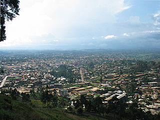
Bamenda, also known as Abakwa and Mankon Town, is a city in northwestern Cameroon and capital of the Northwest Region. The city has a population of about 2 million people and is located 366 km (227 mi) north-west of the Cameroonian capital, Yaoundé. Bamenda is known for its cool climate and scenic hilly location.

Articles related to Cameroon include:

<span class="mw-page-title-main">Kumbo</span> Place in Northwest Region

Kumbo, also known as Kimbo, is the second-largest city in the North West Province of Cameroon and the capital of Bui Division. It lies about 2000m above sea level and is situated approximately 110 km away from Bamenda, on the Bamenda Highlands Ring Road. Kumbo has a population of 80,212 and is split into three distinctive hilly settlements of Tobin, Mbveh, and Squares. The town is known for horse racing and traditional medicine, and also for its palace, a market and two hospitals. Kumbo is the capital city of the Nso Kingdom of the Nso people. The lingua franca is Lamnso but Pidgin, English, Oku, Djottin, Fulfulde, French and Hausa are spoken.

<span class="mw-page-title-main">Kilum-Ijim Forest</span>

The Kilum-Ijim Forest is an area of mountain rainforest in Cameroon's North-West Region. It is found on Mount Oku and the nearby Ijim Ridge in the Cameroon mountains, with Lake Oku lying in a crater in its center. It is the largest area of Afromontane forest left in West Africa. The area is an important one for biodiversity, including the endemic Bannerman's turaco and banded wattle-eye. The forest is the focus of a successful community conservation project, the Kilum-Ijim Forest Project, which works to protect the forest. The project is a collaboration between the Cameroon Ministry of the Environment and BirdLife International, and focuses on sustainable use of the forests, local management, working to benefit both the biodiversity and local development. The programme works so well that the boundaries of the forest, as mapped by satellite imagery, are expanding, and the success of the idea has led to another sister project in Cameroon, the Bamenda Highlands Forest Project.

The Nso people are from the Bamenda grass fields Northwest Region of Cameroon. Their traditional language is Lamnso and their capital is Kumbo – where the Palace of the Fon is found.

<span class="mw-page-title-main">Cameroon line</span> Chain of volcanoes in the Gulf of Guinea

The Cameroon line is a 1,600 km (1,000 mi) long chain of volcanoes that includes islands in the Gulf of Guinea and mountains on the African mainland, from Mount Cameroon on the coast towards Lake Chad on the northeast. They form a natural border between eastern Nigeria and the West Region of Cameroon. The islands, which span the equator, have tropical climates and are home to many unique plant and bird species. The mainland mountain regions are much cooler than the surrounding lowlands, and also contain unique and ecologically important environments.

<span class="mw-page-title-main">Cameroonian Highlands forests</span>

The Cameroonian Highlands forests, also known as the Cameroon Highlands forests, are a montane tropical moist broadleaf forest ecoregion located on the range of mountains that runs inland from the Gulf of Guinea and forms the border between Cameroon and Nigeria. This is an area of forest and grassland which has become more populous as land is cleared for agriculture.

<span class="mw-page-title-main">Western High Plateau</span> Mountainous area in Cameroon

The Western High Plateau, Western Highlands or Bamenda Grassfields is a region of Cameroon characterised by high relief, cool temperatures, heavy rainfall and savanna vegetation. The region lies along the Cameroon line and consists of mountain ranges and volcanoes made of crystalline and igneous rock. The region borders the South Cameroon Plateau to the southeast, the Adamawa Plateau to the northeast and the Cameroon coastal plain to the south.

<span class="mw-page-title-main">Roman Catholic Diocese of Kumbo</span> Roman Catholic diocese in Cameroon

The Roman Catholic Diocese of Kumbo is a Roman Catholic diocese in the Ecclesiastical Province of Bamenda in Cameroon. The first German settlers were Missionaries of the Sacred Heart who arrived in 1912 and established their mission in 1913. The Diocese of Kumbo was erected by Pope John Paul II on Thursday, 18 March 1982, with territory taken from the then Diocese of Bamenda. It is a suffragan diocese of the Metropolitan See of Bamenda along with the Roman Catholic Dioceses of Buea, Kumba, and Mamfe.

<span class="mw-page-title-main">Lake Oku clawed frog</span> Species of amphibian

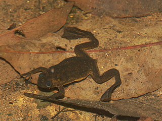
The Lake Oku clawed frog is a species of frog in the family Pipidae, endemic to Lake Oku, a small crater lake in northwest Cameroon. It is a small, dark-coloured, fully aquatic frog with a length of 28 to 36 mm, males being slightly smaller than females. The International Union for Conservation of Nature has rated this frog as "critically endangered" on the basis of its small area of occurrence at a single location, and the possibility that introduction of non-native fish into the lake could cause the frog to be wiped out.

<span class="mw-page-title-main">Mount Oku</span>

Mount Oku, or Kilum Mountain, is the largest volcano in the Oku Massif, in the Cameroon Volcanic Line, located in the Oku region of the Western High Plateau of Cameroon. It is the second highest mountain in mainland Central Africa. The stratovolcano rises to 3,011 metres (9,879 ft) above sea level, and is cut by a large caldera.

<span class="mw-page-title-main">Menchum River</span>

The Menchum River and its tributaries drains a large area of the Northwest Region of Cameroon. It in turn is a tributary of the Benue River in Nigeria.

<span class="mw-page-title-main">Lake Oku</span> Body of water

Lake Oku is a crater lake on the Bamenda Plateau in the Northwest Region of Cameroon. It is located at 2,227 metres (7,306 ft) on Mount Oku, and is completely surrounded by cloud forest.

Oku or OKU may refer to:

This is a timeline of the Anglophone Crisis during 2018.

This is a timeline of the Anglophone Crisis during 2020.

This is a timeline of the Anglophone Crisis during 2021.

This is a timeline of the Anglophone Crisis in Cameroon during 2022.

References

  1. 1 2 "Oku Volcanic Field". Global Volcanism Program . Smithsonian Institution.
  2. 1 2 "Bees, Geographical Indications, and Development". www.wipo.int. 2015. Retrieved 2023-03-29.
  3. Koloss, Hans-Joachim. "Life in the Cameroon Grasslands". Art and Life in Africa. University of Iowa Stanley Museum of Art. Retrieved 2022-02-12.

Coordinates: 6°11′59″N10°31′07″E / 6.19972°N 10.51861°E / 6.19972; 10.51861