Ordeman Townhouse
The Ordeman Townhouse was one of the first buildings to be restored on Old Alabama Town.
 Structure on north side
 Grocery store, south side
 Church, south side
Old Alabama Town is a collection of restored 19th- and 20th-century structures reflecting the lives of the people who settled and developed central Alabama. It stretches along six blocks in the heart of historic downtown Montgomery, Alabama, depicting a cross-section of architecture, history, and lifestyles from an elegant townhouse to rural pioneer living.
Old Alabama Town was developed and is administered by the Landmarks Foundation of Montgomery, a non-profit corporation that came into being in 1967. Since the purchase of the 1850s Ordeman Townhouse and its dependencies in 1968, Landmarks has acquired and restored more than 50 buildings on the site.
The Lucas Tavern serves as the visitor and information center and was formerly located in Waugh along the Federal Road. [1] General Lafayette stayed the night at the tavern on his way to Montgomery. [2]
The Ordeman Townhouse was one of the first buildings to be restored on Old Alabama Town.


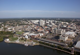
Montgomery is the capital city of the U.S. state of Alabama and the county seat of Montgomery County. Named for Continental Army Major General Richard Montgomery, it stands beside the Alabama River, on the coastal Plain of the Gulf of Mexico. In the 2020 census, Montgomery's population was 200,603. It is now the third most populous city in the state, after Mobile and Huntsville, and is the 119th most populous in the United States. The Montgomery Metropolitan Statistical Area's population in 2020 was 386,047; it is the fourth largest in the state and 142nd among United States metropolitan areas.

Montgomery County is located in the State of Alabama. As of the 2020 census, its population was 228,954, making it the seventh-most populous county in Alabama. Its county seat is Montgomery, the state capital. Montgomery County is included in the Montgomery, AL Metropolitan Statistical Area.

Blountsville is a town in Blount County, Alabama, United States. As of the 2010 census it had a population of 1,684.

Clanton is a city in Chilton County, Alabama, United States. It is part of the Birmingham–Hoover–Cullman Combined Statistical Area. At the 2020 census, the population was 8,768. The city is the county seat of Chilton County. Clanton is near the site of the geographic center of the U.S. state of Alabama.

Maplesville is a town in Chilton County, Alabama, United States. At the 2020 census, the population was 637. It is located approximately halfway between Tuscaloosa and Montgomery on U.S. Route 82.

Wetumpka is a city in and the county seat of Elmore County, Alabama, United States. At the 2020 census, the population was 7,220. In the early 21st century Elmore County became one of the fastest-growing counties in the state. The city is considered part of the Montgomery Metropolitan Area.

Courtland is a town in Lawrence County, Alabama, United States, and is included in the Decatur Metropolitan Area, as well as the Huntsville-Decatur Combined Statistical Area. The population was 609 at the 2010 census, down from 769 in 2000.

Lowndesboro is a town in Lowndes County, Alabama, United States. At the 2010 census the population was 115, down from 140 in 2000. It is part of the Montgomery Metropolitan Statistical Area. Although initially incorporated in 1856 by an act of the state legislature, it lapsed and was not reincorporated until 1962.

Pike Road is a town in Montgomery County, Alabama, United States. As of the 2020 census, the population was 9,439, up from 5,406 at the 2010 census. It is part of the Montgomery metropolitan area.

The Battle of Montgomery's Tavern was an engagement which took place on December 7, 1837 during the Upper Canada Rebellion. The abortive revolutionary insurrection, inspired by William Lyon Mackenzie, was crushed by British authorities and Canadian volunteer units near John Montgomery's tavern on Yonge Street at Eglinton, north of Toronto.
The Alabama State Fairgrounds, also known as Fair Park, was the former home of the Alabama State Fair and the Birmingham International Raceway, and is located in West Birmingham, Jefferson County, Alabama, United States. It is located adjacent to the Five Points West shopping area.

Barryville is a hamlet in Highland, Sullivan County, New York, United States. Previously known as "The River," the hamlet was renamed for William T. Barry, postmaster general under President Andrew Jackson.
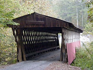
The Easley Covered Bridge, also known as the Old Easley Covered Bridge or Rosa Covered Bridge, is a county-owned wood and metal combination style covered bridge that spans Dub Branch of the Calvert Prong of the Little Warrior River in Blount County, Alabama, United States. It is located on Easley Bridge Road off U.S. Route 231, just south of the town of Rosa, about 5 miles northwest of Oneonta. Coordinates are 33°58′16″N86°31′07″W.

The First Unitarian Church is a historic church and congregation at 12 West Franklin Street in Mount Vernon, Baltimore, Maryland. Dedicated in 1818, it was the first building erected for Unitarians in the United States. The church is a domed cube with a stucco exterior. The church, originally called the "First Independent Church of Baltimore", is the oldest building continuously used by a Unitarian congregation. The name was changed in 1935 to "The First Unitarian Church of Baltimore " following the merger with the former Second Universalist Church at East Lanvale Street and Guilford Avenue in midtown Baltimore. The American Unitarian Association and the Universalist Church of America (established 1866) representing the two strains of Unitarian Universalism beliefs and philosophies merged as a national denomination named the Unitarian Universalist Association in May 1961.

The First Baptist Church on North Ripley Street in Montgomery, Alabama, is a historic landmark. Founded in downtown Montgomery in 1867 as one of the first black churches in the area, it provided an alternative to the second-class treatment and discrimination African-Americans faced at the other First Baptist Church in the city.
Cloverdale-Idlewild is a neighborhood in Montgomery, Alabama. It is circumscribed by Edgemont Street, Norman Bridge Road, Fairview Avenue, and Audubon Road.
Pintlala, also known as Pint Lala or Colquitt, is an unincorporated community in Montgomery County, Alabama, United States, located on U.S. Route 31, 15.6 miles (25.1 km) south of Montgomery.
Waugh is an unincorporated community in Montgomery County, Alabama, United States, located at the intersection of U.S. Route 80 and Alabama State Route 126, 15.3 miles (24.6 km) east of Montgomery.

Fort Bainbridge was an earthen fort located along the Federal Road on what is today the county line between Macon and Russell counties in Alabama. Fort Bainbridge was located twenty-five miles west of Fort Mitchell.
Exchange Place is a street in the Financial District of Lower Manhattan, New York City. The street runs five blocks between Trinity Place in the west and Hanover Street in the east.
| International | |
|---|---|
| National | |
32°22′53″N86°18′12″W / 32.38139°N 86.30333°W
| | This Montgomery County, Alabama state location article is a stub. You can help Wikipedia by expanding it. |