
The River Gipping is the source river for the River Orwell in the county of Suffolk in East Anglia, England, which is named from the village of Gipping, and which gave its name to the former Gipping Rural District. It rises near Mendlesham Green and flows in a south-westerly direction to reach Stowmarket. From there it flows towards the south or south east, passing through Needham Market then Baylham. The river continues to flow south between Great Blakenham and Claydon, and through Bramford and Sproughton until it flows into Ipswich, where it becomes the Orwell at Stoke Bridge. The river has supplied power to a number of watermills, several of which are still standing. None are operational, although the mill at Baylham retains most of its machinery, and is the only complete mill on the river.
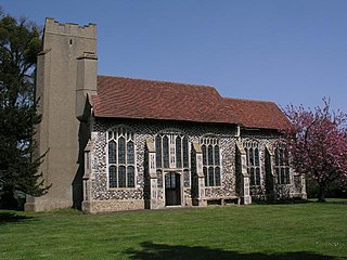
Gipping is a village and civil parish in the Mid Suffolk district of Suffolk in eastern England. Located around three miles north north-east of Stowmarket, in 2005 its population was 80. At the 2011 Census the population remained less than 100 and was included in the civil parish of Old Newton with Dagworth.

Norton is a village and civil parish in the Mid Suffolk district of the English county of Suffolk. The name Norton means northern town or farm. Located close to the A14, its nearest railway station is at Elmswell, just over 3 miles (5 km) away. The closest towns are Stowmarket 8 miles (13 km) away and Bury St Edmunds, around 10 miles (16 km) away.

Stowmarket is a market town in Suffolk, England, on the busy A14 trunk road between Bury St Edmunds to the west and Ipswich to the southeast. The town lies on the Great Eastern Main Line (GEML) between Diss and Needham Market, and lies on the River Gipping, which is joined by its tributary, the River Rat, to the south of the town.
Stowupland is a village 1 mile (2 km) east of Stowmarket, Suffolk, England. Stowupland means "a place occupied on higher ground than Stowmarket", with the Saxons calling the village Ultuna due to the far higher presence of owls in the woods that previously stood on the site of Holy Trinity Church. Stowupland High School is found in the village.

Badley is a village and civil parish in Suffolk, England. It is located between Stowmarket and Needham Market, in the Mid Suffolk district. With an electorate of less than 100, it has an infrequent parish meeting rather than a parish council. The population is included in the town of Needham Market. Badley is listed as a settlement with 41 households in the 1086 Domesday Book.In 1901 the population was 77, and the parish covered 1 050 acres.

Combs is a village and civil parish in the English county of Suffolk. It is also located directly to the south of Stowmarket, with a half-mile (800m) of glacial valley known locally as 'Slough'.

Great Finborough is a village and civil parish in the Mid Suffolk district, in the county of Suffolk, England; about 3 miles (5 km) south west of Stowmarket and near one of the sources of the River Gipping. It has two schools, a pub and an active church. In 2001 the parish had a population of 755, increasing to 808 at the 2011 Census.

Onehouse is a small village in the English county of Suffolk, about 3 miles west from the centre of Stowmarket near to the Golf Club. The population of the parish at the 2011 Census was 810.

Newton, also known as Newton Green to distinguish it from Nowton near Bury St Edmunds, and Old Newton near Stowmarket, is a small village and civil parish in Suffolk, England. Part of Babergh district, it is located on the A134 between Sudbury and Colchester, around three miles from the former.

Finningham is a village and civil parish in the Mid Suffolk district of Suffolk in the East of England, located approximately 7.5 miles north of Stowmarket and 16 miles from the county town of Ipswich. In 2011 its population was 480.

Old Newton with Dagworth is a civil parish in the Mid Suffolk district of Suffolk, England. The parish contains the village of Old Newton, as well as the hamlets of Brown Street, Dagworth and Ward Green. In 2005 its population was 1,050. The parish shares a parish council with neighbouring Gipping.

Little Stonham, also known as Stonham Parva, is a village and civil parish in the Mid Suffolk district of Suffolk in eastern England. Located just off the A140, around three miles east of Stowmarket, in 2005 its population was 350.

Winston is a village and civil parish in the Mid Suffolk district of Suffolk in eastern England. Located around 8 miles (13 km) east of Stowmarket, the 2011 Census showed that the population of the parish of Winston is 159. The parish also contains the settlements of Winston Green and Fenn Street. There is a church and an old school room, and every year there is a Winston Village Fete. A lot of the village of Winston is based around 14th Century Church, with multiple 16th Century cottages and farmhouses along church lane, showing the villages agricultural past, the area of Winston is still agricultural based with farms and fields all over the parish. Winston and the surrounding area is approximately 45m-50m above sea level making the area unlikely to flood, unless in exceptional circumstances. In the 1870s Winston was described as:
Winston, a parish, with a village, in Bosmere district, Suffolk; 1 mile SSE of Debenham, and 7 NE of Needham r. station.
Rattlesden is a village and civil parish in the Mid Suffolk district of Suffolk in eastern England. It is approximately 15 miles (24 km) north-west from the county town of Ipswich, with the nearest town Stowmarket 4 miles (6 km) to the east. The parish includes the hamlets of Hightown Green and Poystreet Green.
Ringshall is a village and civil parish in the Mid Suffolk district of Suffolk in eastern England. Located around four miles south of Stowmarket, and 13 miles north west of Ipswich.

Naughton is a village and former civil parish, now in the civil parish of Nedging-with-Naughton, in the Babergh district, in the county of Suffolk, England. It is 10 miles (16 km) north-west of Ipswich and 7 miles (11 km) south-west of Stowmarket. It was historically within the Cosford Hundred of Suffolk. The civil parish was merged with Nedging on 1 April 1935 to create "Nedging with Naughton". In 1931 the civil parish had a population of 98.

In the 2011 United Kingdom local elections, the Conservative Party held onto the Mid Suffolk District Council for a third term and even increased their majority. The Liberal Democrats lost four seats but remained in second place while the Green Party and the Labour Party each gained a seat, which is Labour's only seat on the Council.

The 2015 Mid Suffolk District Council election took place on the 7 May 2015 to elect members of Mid Suffolk District Council in England. It was held on same day as many UK local elections and the general election.

