Old Toongabbie

Last updated

Old Toongabbie
Greater Western Sydney,  New South Wales
North-West T-way Old Windsor.jpg
North-West T-way Old Windsor Rd at Old Toongabbie
Old Toongabbie
Population3,133 (2016 census) [1]
Established1792
Postcode(s) 2146
Elevation37 m (121 ft)
Location29 km (18 mi) west of Sydney CBD
LGA(s) City of Parramatta
Region Greater Western Sydney
State electorate(s) Winston Hills
Federal division(s)
Suburbs around Old Toongabbie:
Seven Hills Winston Hills Winston Hills
Toongabbie Old Toongabbie Constitution Hill
Pendle Hill Wentworthville Wentworthville
Old Toongabbie Post Office 1901 ToongabbiePostOffice1901.jpg
Old Toongabbie Post Office 1901

Old Toongabbie is a suburb of Greater Western Sydney, in the state of New South Wales, Australia 29 kilometres west of the Sydney central business district in the local government area of the City of Parramatta.

Contents

Old Toongabbie is noted for being the third post colonisation settlement, chosen for its location on a main waterway.

Origin of the Suburb Name

Toongabbie is derived from an Aboriginal word, reported as meaning place by the water or meeting by the water. It was named in June 1792 after Governor Arthur Phillip asked the local Aboriginal people what they called the place. It is the oldest official use of an Aboriginal place-name – Parramatta (the Aboriginal place name) was founded earlier was first called Rose Hill.

“Old Toongabbie” became the name of the location of the original town (located next to Toongabbie Creek) as opposed to “Toongabbie” which was near to the Western Railway station. Part of the suburb later became known as Constitution Hill, Winston Hills and Pendle Hill.

History

The traditional inhabitants of the land included the Tugagal clan of the Dharug peoples [2] .

European settlement

The First Fleet arrived in 1788.

In 1788 the Parramatta area was settled, then called Rose Hill, as a government farm for the colony.

In 1791 there were food shortages and David Collins referred to ‘new ground’ as the area chosen 2.4km from Parramatta, later to be known as Toongabbie [3] .

Boat travel was the fastest method of transportation in early Australian history for both the original inhabitants and the new settlers. This area was chosen because of the location on the meeting of two waterways, Toongabbie Creek and Quarry Creek [3] . The Aboriginal inhabitants were consulted and the ‘Toongabbie’ is thought to mean ‘a place near the water’ which became the name of the town.

Toongabbie was founded as a Government Farm to grow food for the colony in April 1792.

Life of convicts at Toongabbie

The working conditions of the convicts at Toongabbie were harsh and these workers had hard lives [3] . They often worked without adequate food and using primitive tools in the harsh sun. Their work included felling tress, digging up stumps and carrying the timber to convenient places for use or transportation. Using simple spades, hoes or their bare hands they uprooted local vegetation and grass to make way for crops and houses. Superintendents often mistreated the convicts and there were reports of 7 or 8 persons per day dying on the job from overwork, malnutrition, heat stroke, the cold and possibly lack of sleep etc. Sometimes workers would die on the way to the hospital or while waiting in line for their meal. Living conditions included crowded quarters such as up to 18 people living in a small hut. They often didn’t have blankets, beds, eating utensils or warm clothes for winter months [3] .

Post farm operations

After eleven years, the government farm was closed and the land was given as grants to settlers and convicts who had done their time.

In 1860, the railway was extended to Blacktown but it took 20 years before any arrangements were made for trains to stop at Toongabbie. The first school in Toongabbie, [4] opened on 3 May 1886. By April 1911, the school closed due to low enrolments. The school reopened February the next year and has stayed open ever since. [5]

The first post office in the area was opened after many years of campaigning by local residents in 1887 in a private house on Old Windsor Road and this arrangement continued until the 1960s. The first post master was a Mr Birks wand he was paid 25 pounds a year to manage the office and bring the mail bag over from Seven Hills on horseback each day. By 1922 the number of residents and businesses had grown sufficiently to support a second office in a weatherboard cottage in Wentworth Avenue, known as Toongabbie West. A purpose built office was opened in the main shopping area in Portico Parade in 1960 becoming Toongabbie Post Office whilst the old Toongabbie Post Office was renamed Old Toon [6]

The area continued to be known as Toongabbie until the construction of the Main Western railway line and the building of the railway station of Toongabbie. Over time the location of the station and the shops around it became known as Toongabbie and the original settlement was called Old Toongabbie to differentiate the two.

From the 1990s part of this area was unofficially known as the locality of Constitution Hill. The suburb of Constitution Hill was officially recognised in 2007.

Geography

The area is bounded on the north east by Toongabbie Creek, a tributary of the Parramatta River. Although Toongabbie is relatively densely settled, in recent years programs of bushland regeneration, pollution control and remedial works to local waterways have seen a surprising return by several rare wildlife species, and in the 1990s platypus were reported to have returned to sections of Toongabbie Creek.

Notable residents

Related Research Articles

<span class="mw-page-title-main">Castle Hill, New South Wales</span> Town in New South Wales, Australia

Castle Hill is a town in Sydney, New South Wales, Australia, located 34 kilometres north-west of the Sydney central business district and 9.5 kilometres north of Parramatta. It is within the Hills District region, split between the local government areas of The Hills Shire and Hornsby Shire.

<span class="mw-page-title-main">North Rocks, New South Wales</span> Suburb of Greater Western Sydney, New South Wales, Australia

North Rocks is a suburb straddling the Hills District and Parramatta within Greater Western Sydney, in the state of New South Wales, Australia, located 26 kilometres north-west of the Sydney central business district. Following the amalgamation of council areas in 2016, the majority of North Rocks falls into the council area of the City of Parramatta. Streets north of the M2 Hills Motorway are within The Hills Shire.

<span class="mw-page-title-main">Carlingford, New South Wales</span> Suburb of Sydney, New South Wales, Australia

Carlingford is a suburb of Sydney, in the state of New South Wales, Australia. Carlingford is 22 kilometres north-west of the Sydney central business district in the local government area of City of Parramatta. Carlingford sits at the meeting point of Northern Sydney and Western Sydney sitting on both sides of Pennant Hills Road which generally acts as a divider of the two regions. While being part of City of Parramatta, it is sometimes referred to as being part of the Hills District.

<span class="mw-page-title-main">Greater Western Sydney</span> Region of the metropolitan area of Sydney, Australia

Greater Western Sydney (GWS) is a large region of the metropolitan area of Greater Sydney, New South Wales (NSW), Australia that generally embraces the north-west, south-west, central-west, far western and the Blue Mountains sub-regions within Sydney's metropolitan area and encompasses 11 local government areas: Blacktown, Blue Mountains, Camden, Campbelltown, Cumberland, Fairfield, Hawkesbury, Liverpool, Parramatta, Penrith and Wollondilly. It includes Western Sydney, which has a number of different definitions, although the one consistently used is the region composed of ten local government authorities, most of which are members of the Western Sydney Regional Organisation of Councils (WSROC). The NSW Government's Office of Western Sydney calls the region "Greater Western Sydney".

<span class="mw-page-title-main">Westmead, New South Wales</span> Suburb of Sydney, New South Wales, Australia

Westmead is a suburb in Sydney, in the state of New South Wales, Australia. Westmead is located 26 kilometres west of the Sydney central business district in the local government area of Cumberland Council and is part of the Greater Western Sydney region.

<span class="mw-page-title-main">Northmead, New South Wales</span> Suburb of Greater Western Sydney, New South Wales, Australia

Northmead is a suburb of Greater Western Sydney, in the state of New South Wales, Australia. Northmead is located 26 kilometres west of the Sydney central business district, in the local government area of the City of Parramatta.

<span class="mw-page-title-main">Summer Hill, New South Wales</span> Suburb of Sydney, New South Wales, Australia

Summer Hill is a suburb of Sydney, in the state of New South Wales, Australia. Summer Hill is located 7 kilometres west of the Sydney central business district, in the local government area of the Inner West Council.

<span class="mw-page-title-main">Hills District, New South Wales</span> Region in New South Wales, Australia

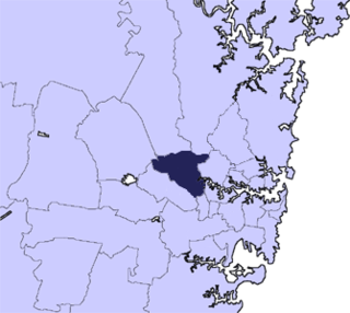
The Hills District is a region of Sydney, within the northern part of the Greater Western Sydney region of Sydney, in the state of New South Wales, Australia. Stretching from the M2 Hills Motorway in the south to the Hawkesbury River in the north and Old Windsor Road in the west to Pennant Hills Road and Berowra Creek in the east. The region is often considered to be synonymous with the local government area of The Hills Shire, however in a more expansive sense colloquial definitions can also include surrounding areas such as the western portion of the Hornsby Shire, as well as also sometimes including northern parts of City of Parramatta and Blacktown City Council.

<span class="mw-page-title-main">Seven Hills, New South Wales</span> Suburb of Sydney, New South Wales, Australia

Seven Hills is a suburb in the Greater Western Sydney region of Sydney, in the state of New South Wales, Australia, located 33 kilometres North West of the Sydney central business district. Seven Hills is within the local government areas of the City of Parramatta and Blacktown City councils.

<span class="mw-page-title-main">South Creek (New South Wales)</span> Creek in Sydney, Australia

The South Creek or Wianamatta is a creek that is part of the Hawkesbury-Nepean catchment, located on the Cumberland Plain in Greater Western Sydney, New South Wales, Australia.

<span class="mw-page-title-main">Toongabbie</span> Suburb of Sydney, New South Wales, Australia

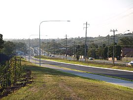
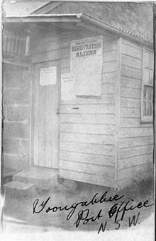
Toongabbie is a suburb of Sydney, in the state of New South Wales, Australia. One of the oldest suburbs in Sydney, Toongabbie is located approximately 30 kilometres west of the Sydney central business district and is part of the Greater Western Sydney region. Toongabbie is split between the local government areas of the City of Parramatta, the City of Blacktown and Cumberland Council. The suburb is often locally referred to as "Toonie", "Toonga Bay" and "Bayside".

<span class="mw-page-title-main">Wentworthville, New South Wales</span> Suburb of Sydney, New South Wales, Australia

Wentworthville is a suburb in Sydney, in the state of New South Wales, Australia. Wentworthville is located 27 kilometres west of the Sydney central business district and is part of the Greater Western Sydney region. Wentworthville is split between the local government areas of the City of Parramatta and the Cumberland Council. Wentworthville is colloquially known as 'Wenty'.

<span class="mw-page-title-main">Winston Hills, New South Wales</span> Suburb of Sydney, New South Wales, Australia

Winston Hills is a suburb of Sydney, in the state of New South Wales, Australia. Winston Hills is located 28 kilometres west of the Sydney central business district in the local government areas of the City of Parramatta and The Hills Shire. Winston Hills is part of the Hills District region of Greater Western Sydney.

<span class="mw-page-title-main">City of Parramatta</span> Local government area in New South Wales, Australia

The City of Parramatta, also known as Parramatta Council, is a local government area located to the west and north-west of Sydney CBD in the Greater Western Sydney region. Parramatta Council is situated between the City of Ryde and Cumberland, where the Cumberland Plain meets the Hornsby Plateau, approximately 25 kilometres (16 mi) west of the Sydney central business district, in New South Wales, Australia. The city occupies an area of 84 square kilometres (32 sq mi) spanning across suburbs in Greater Western Sydney including the Hills District, and a small section of Northern Sydney to the far north east of its area. According to the 2016 census, City of Parramatta had an estimated population of 226,149. The city houses the Parramatta central business district which is one of the key suburban employment destinations for the region of Greater Western Sydney.

<span class="mw-page-title-main">Pendle Hill, New South Wales</span> Suburb of Sydney, New South Wales, Australia

Pendle Hill is a suburb of Sydney, in the state of New South Wales, Australia. Pendle Hill is located 29 kilometres west of the Sydney central business district, in the local government areas of Cumberland Council and City of Parramatta and is part of the Greater Western Sydney region.

<span class="mw-page-title-main">Camellia, New South Wales</span> Suburb of Sydney, New South Wales, Australia

Camellia is a suburb of Sydney, in the state of New South Wales, Australia. Primarily industrial with no residential population, environmental remediation commenced in late 2015, with the suburb ear-marked as a major centre for future high density living.

<span class="mw-page-title-main">Constitution Hill, New South Wales</span> Suburb of Sydney, New South Wales, Australia

Constitution Hill is a suburb of Sydney in the state of New South Wales, Australia. Constitution Hill is located on a hill 28 kilometres (17 mi) west of the Sydney central business district in the local government area of the City of Parramatta and is part of the Western Sydney region. Constitution Hill overlooks the city of Parramatta from above and contains views of the inner Sydney city skyline.

<span class="mw-page-title-main">Toongabbie Creek</span> River in New South Wales, Australia

Toongabbie Creek, an urban watercourse that is part of the Parramatta River catchment, is located in Greater Western Sydney, New South Wales, Australia.

<span class="mw-page-title-main">Darling Mills Creek</span> River in New South Wales, Australia

The Darling Mills Creek, an urban watercourse that is part of the Parramatta River catchment, is located in Greater Western Sydney, New South Wales, Australia.

The Toongabbie Government Farm Archaeological Site is the heritage-listed site of a former convict government farm at Goliath Avenue, Winston Hills, City of Parramatta, New South Wales, Australia. The farm was built by convict labour from 1791 to 1813. Its site includes areas today known as Palestine Park, Oakes Reserve and Settlers Walk and is also known as the Toongabbie Government Farm Convict Site. It was added to the New South Wales State Heritage Register on 11 December 2012.

References

  1. Australian Bureau of Statistics (27 June 2017). "Old Toongabbie (State Suburb)". 2016 Census QuickStats. Retrieved 21 December 2017. OOjs UI icon edit-ltr-progressive.svg
  2. "Old Toongabbie - Origin of Street Names | Parramatta History and Heritage". historyandheritage.cityofparramatta.nsw.gov.au. Retrieved 1 May 2024.
  3. 1 2 3 4 "Old Toongabbie - Origin of Street Names | Parramatta History and Heritage". historyandheritage.cityofparramatta.nsw.gov.au. Retrieved 1 May 2024.
  4. http://www.toongabbie-p.schools.nsw.edu.au/ Toongabbie Public School
  5. Sargeant, Doris A. and others, The Toongabbie Story, Toongabbie, 1964 published by the Toongabbie Public School
  6. Toongabbie, The Third Settlement, John Goode, The third settlement bicentennial committee, 1988, Published in Australia, ISBN   0-7316-2169-7

33°47′13″S150°57′58″E / 33.78694°S 150.96611°E / -33.78694; 150.96611