
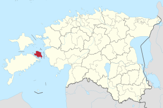
Saaremaa is the largest island in Estonia, measuring 2,673 km2 (1,032 sq mi). The main island of Saare County, it is located in the Baltic Sea, south of Hiiumaa island and west of Muhu island, and belongs to the West Estonian Archipelago. The capital of the island is Kuressaare, which in January 2018 had 13,276 inhabitants. The whole island had a recorded population in January 2020 of 31,435.

Hiiumaa is the second largest island in Estonia and is part of the West Estonian archipelago, in the Baltic Sea. It has an area of 989 km2 and is 22 km from the Estonian mainland. Its largest town is Kärdla. It is located within Hiiu County.

Kuressaare is a town on Saaremaa island in Estonia. It is the administrative centre of Saaremaa Parish and the capital of Saare County. Kuressaare is the westernmost town in Estonia. The recorded population on 1 January 2018 was 13,276.
Muhu, is an island in the West Estonian archipelago of the Baltic Sea. With an area of 198 km2 (76 sq mi) it is the third largest island belonging to Estonia, after Saaremaa and Hiiumaa.

The Baltic Sea Campaigns were conducted by Axis and Allied naval forces in the Baltic Sea, its coastal regions, and the Gulf of Finland during World War II. After early fighting between Polish and German forces, the main combatants were Germany and Finland, opposed by the Soviet Union. Sweden's navy and merchant fleet played important roles, and the British Royal Navy planned Operation Catherine for the control of the Baltic Sea and its exit choke point into the North Sea.

Osmussaar is an Estonian island situated in the mouth of the Gulf of Finland in the Baltic Sea, 7.5 km off the Estonian mainland. Administratively the island is part of Lääne-Nigula Parish in Lääne County. Its area is 4.8 km2.

The minelayer HNoMS Olav Tryggvason was built by the naval shipyard at Horten in the early 1930s and had build number 119. She served in the Royal Norwegian Navy until captured by the Germans in 1940. The Germans renamed her first Albatros II, and a few days later Brummer. She was wrecked in a British bombing raid in northern Germany in April 1945.
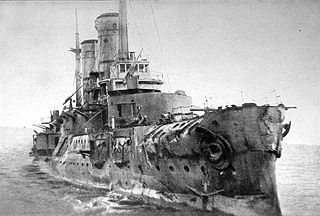
The Battle of Moon Sound was a naval battle fought between the forces of the German Empire, and the then Russian Republic in the Baltic Sea during Operation Albion from 16 October 1917 until 3 November 1917 during World War I. The German intention was to destroy the Russian forces and occupy the West Estonian Archipelago. The Imperial German Navy had one battlecruiser, 10 battleships, nine light cruisers, one mine cruiser, 50 destroyers and six submarines while the Russians had only two pre-dreadnoughts, three cruisers, three gunboats, 21 destroyers, plus three British submarines.
Operation North Wind was a joint German-Finnish naval operation in the Baltic Sea in 1941, in the course of World War II. The operation itself was a distracting manoeuvre so that another German force could occupy the Estonian islands of Hiiumaa, Saaremaa and Muhu without the interference of the Soviet Red Fleet.

West Estonian archipelago is a group of Estonian islands located in the Baltic Sea around Väinameri. The total area is about 4,000 km2 (1,500 sq mi). The archipelago is composed of the islands Saaremaa, Hiiumaa, Muhu, Vormsi and about 900 other smaller islands.
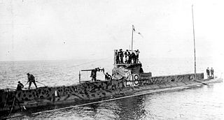
A British submarine flotilla operated in the Baltic Sea for three years during the First World War. The squadron of nine submarines was attached to the Russian Baltic Fleet. The main task of the flotilla was to prevent the import of iron ore from Sweden to Imperial Germany. The success of the flotilla also forced the German Navy in the Baltic to keep to their bases and denied the German High Seas Fleet a training ground. The flotilla was based in Reval (Tallinn), and for most of its career commanded by Captain Francis Cromie.

Sõrve Peninsula is a peninsula which forms the southernmost section of the Estonian island Saaremaa. Its length is 32 km, and its maximum width 10 km. South of it lies Irbe Strait, the main entrance to the Gulf of Riga of the Baltic Sea.
The Battle of Tehumardi was a battle related to the Moonsund Operation during World War II. Soviet soldiers fought German troops occupying Tehumardi. It was one of the most brutal engagements during the fighting on the Estonian island of Saaremaa (Oesel) in 1944.

Väinatamm is the name of the largest causeway in Estonia on the Estonian national road 10. The causeway, opened in 1896, connects the island of Muhu, located between Saaremaa and the continent, with Saaremaa. Construction of the causeway cut the sea crossing between the continent and Saaremaa by about half, and transit time even further. In 1917, the causeway was the site of heavy fighting during Operation Albion, as German bicycle troops attempted to cut off and encircle retreating Russian forces, while securing the route to Muhu.
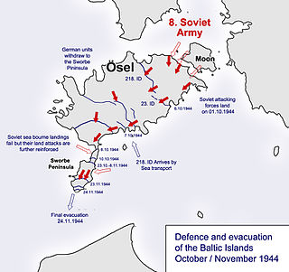
The Moonsund landing operation, also known as the Moonzund landing operation, was an amphibious operation and offensive by the Red Army during World War II, taking place in late 1944. It was part of the Baltic offensive, and was designed to clear German forces of Army Group North from the islands in East Baltic Sea, the West Estonian archipelago. The attacking forces were from the 8th Army of the Leningrad Front.

Estonia was under military occupation by the German Empire during the later stages of the First World War. On 11–21 October 1917, the Imperial German Army occupied the West Estonian archipelago, including the larger islands of Saaremaa (Ösel), Hiiumaa (Dagö), and Muhu (Moon).
Kõrgelaid is a small, uninhabited, moraine-based island in the Baltic Sea, belonging to the country of Estonia. Its coordinates 58°45′09″N23°05′35″E.
