Orbirail

Last updated

Unofficial diagram of completed circular London Overground network London Overground as a circle.svg
Unofficial diagram of completed circular London Overground network

Orbirail was a name for a suggested orbital railway route around London.

Contents

It would have connected the extended North London Line, East London Line, the South London Line and the West London Line, possibly including the Gospel Oak to Barking Line. The combined line would have orbited London in Zone 2, Zone 3 and (possibly) Zone 4.

It is not to be confused with London's existing circular railway, the Circle line of the London Underground.

Status

Although Orbirail had no official status as a planned project, the completion of Transport for London's London Overground on 9 December 2012 achieved substantially the same objective.

On 12 February 2009, Mayor Boris Johnson and Transport Secretary Geoff Hoon announced £75 Million to fund the southern extension of the Overground network between Surrey Quays and Clapham Junction as part of the East London line extension, creating the final connection of an orbital railway for London to be completed in time for the 2012 Summer Olympics. [2] However, the timeline published by TfL in April 2011 stated the line would not open until late 2012, well after both the Summer Olympics and Paralympics. [3]

History of orbital railways in London

The Inner Circle and other circular routes The Circle Routes of Victorian London.png
The Inner Circle and other circular routes

London's railway system was largely built in the 19th century, by competing private companies. The benefits of an integrated transport system were unknown at this time and each main-line railway company built its own terminus in central London and operated radial routes from that point. For example, Waterloo railway station in south-west central London is the focus of lines radiating out to the south and west. Meanwhile, metropolitan and suburban railways developed also on radial lines.

The first orbital rail service was the Inner Circle, now the Circle line, operated over the central sections of the Metropolitan line and District line. This linked most of the main-line stations and was a commercial success.

This success led to the operation of a number of other semi-orbital routes within the capital, over existing main-line routes and sections of the Inner Circle:

London was a much smaller city than it is now and most commercial activity was focused at the centre. These outer routes failed to attract the passenger numbers hoped for and were eventually cut back or ended while other, more radial services on the lines continued.

Other semi-orbital routes fared little better. Throughout the 20th century London's railways operated on a radial model and the few remaining semi-orbital passenger routes withered, with the lines used mainly for freight services. The national railway network was privatised with radial franchises. Only the Circle line enjoyed success.

Throughout the 20th century London expanded both in size and population and employment ceased to be as heavily concentrated in the centre. Many more people were travelling through central London by Underground and many of them were travelling in on one radial route only to travel out again on another. Congestion increased and additional Underground lines were built at great expense.

The idea of reviving and expanding the semi-orbital routes to relieve some of the load on central London in a more cost-effective way than the building of new tube lines was considered, coalescing around the suggested name "Orbirail", but it won few friends in the National Rail network for commercial and operational reasons.

Map of the London Overground (excluding the Euston-Watford line), with all proposed changes in place London overground future.png
Map of the London Overground (excluding the Euston-Watford line), with all proposed changes in place

The situation changed drastically with the creation of Transport for London as a single body with overall responsibility for transport in London. During Ken Livingstone's term as Mayor of London, TfL exploited the potential in the neglected peripheral rail routes and started to plan a complete orbital rail system by joining these routes together (albeit with no plan for a single fully orbital service). The new system was eventually launched as the London Overground, and work continues to complete the orbital route as more lines are added to the system. The eventual London Overground network will (by 2013) cover a route which bears a striking resemblance to the Outer Circle line with the East London line extension and South London Line being used to complete the loop.

Political support for the principle of Orbirail continued after the change of leadership following the 2008 London mayoral election. During his election campaign, Boris Johnson published a transport manifesto which highlighted the problems associated with orbital journeys around London: [4]

R25

The R25 was a proposed railway orbital around the Zone 3 area of London. First proposed in the Mayor of London's £1.3 trillion London Infrastructure 2050 plan, the line would have used some existing Network Rail and London Overground lines, linked by stretches of new railway. [5]

Arguments for and against

TfL estimate that just under half of all Londoners' journeys start and finish in outer London. Only around a quarter of these are made by public transport. This is because public transport options for orbital journeys are poor by comparison to the car. One of the limitations of the public transport network in outer London is the lack of direct and convenient orbital routes. (...) In fact, many orbital routes are only made accessible by making a radial journey into central London.

The manifesto noted that 64% of journeys in outer London were made by cars or vans, and suggested that improved orbital public transport would help to reduce this figure, proposing a trial of orbital express bus routes linking key suburban rail terminals.

Orbirail's proponents believe that it would be a relatively low-cost project, involving only a small amount of new track, some improvements to existing lines and an increase in train frequency. It would allow many people to make journeys without passing through Zone 1, thus relieving congestion on central London's railways.

There are complications which could prevent these lines running as single fully orbital route. Orbital railways have an intrinsic timetabling robustness problem. The trains are constantly "in orbit" so there is little scope for "recovery time" if they are delayed. A single delay can have long-lasting knock-on effects and be much more disruptive than on a radial railway. Recovery time can be created by timetabling for longer stops at some stations but this increases journey times and reduces train frequency. (For this reason, on 13 December 2009 the Circle line was changed to a spiral route with distinct endpoints.) In this light, it is hard to see a larger and more complicated orbital railway being approved.

An alternative to a single fully orbital route would be two or more semi-orbital routes that join to encircle London. TfL's London Overground is an example of this: in Clapham Junction and in Highbury and Islington, the two halves of the London Overground Orbital Route meet.

An additional problem is poor interchange with many of the radial routes. The proposed route offers no interchange with the Great Western Main Line, Chiltern Main Line, the East Coast Main Line, the Great Eastern Main Line or the London, Tilbury and Southend line. Only local services on the West Coast Main Line stop at Willesden Junction. It has similarly poor interchange with many London Underground lines. Poor interchange options are a general problem with most of London's older railways, which were built by competing private companies in the 19th century before the need for a coherent and integrated transport network was understood.

Related Research Articles

<span class="mw-page-title-main">Tube map</span> Schematic map of the London Underground network

The Tube map is a schematic transport map of the lines, stations and services of the London Underground, known colloquially as "the Tube", hence the map's name. The first schematic Tube map was designed by Harry Beck in 1931. Since then, it has been expanded to include more of London's public transport systems, including the Docklands Light Railway, London Overground, the Elizabeth line, Tramlink, the London Cable Car and Thameslink.

<span class="mw-page-title-main">Clapham Junction railway station</span> National railway station in London, England

Clapham Junction railway station is a major railway station and transport hub near St John's Hill in south-west Battersea in the London Borough of Wandsworth. It is 2 miles 57 chains from London Victoria and 3 miles 74 chains from London Waterloo; it is on both the South West Main Line and Brighton Main Line as well as numerous other routes and branch lines passing through or diverging from the main lines at this station. Despite its name, Clapham Junction is not located in Clapham, a district situated approximately 1 mile (1.6 km) to the south-east and is instead sited in Battersea.

<span class="mw-page-title-main">North London line</span> Railway line in London

The North London line (NLL) is a railway line which passes through the inner suburbs of west, north-west, north, and east London, England between Richmond in the south-west and Stratford in the east, avoiding central London. Its route is a rough semicircle.

<span class="mw-page-title-main">South London line</span> Railway line in inner south London

The South London line is a railway line in inner south London, England. The initial passenger service on the route was established by the London, Brighton & South Coast Railway on 1 May 1867 when the central London terminal stations of Victoria and London Bridge were connecting to the inner south London suburbs of Clapham, Brixton, Camberwell and Peckham. Since 2012 passenger services have been part of London Overground and run between Clapham Junction and Peckham Rye continuing toward Highbury & Islington via the East London line. The line is 8.5 miles (13.7 km) long and consists of seven stations, one of which marks the crossover into the East London line network. Most of the line was built on a high level viaduct above other transport infrastructure. Interchanges with the London Underground are at Clapham High Street and the closest on its London Overground extension is Canada Water. The line is in Travelcard Zone 2.

<span class="mw-page-title-main">Surrey Quays railway station</span> London Overground station

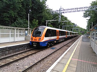
Surrey Quays is a station on the East London Line of the London Overground. It is located in Rotherhithe, part of London Borough of Southwark. It is in Zone 2 and the next station to the north is Canada Water, and to the south it splits into branches to Clapham Junction, New Cross and Crystal Palace/West Croydon. Closed in late 2007, the station was refurbished and re-opened as part of the London Overground network on 27 April 2010.

<span class="mw-page-title-main">Clapham High Street railway station</span> London Overground station

Clapham High Street railway station is on the South London line in Clapham, within the London Borough of Lambeth, Greater London. It is 6 miles 21 chains (10.1 km) measured from London Bridge. It is served by London Overground services, with a limited service to Battersea Park under the control of the London Rail division of Transport for London.

<span class="mw-page-title-main">Brockley railway station</span> National rail station in London, England

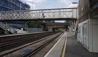
Brockley railway station serves the south-east London district of Brockley and is on the main railway line between London Bridge and Brighton. It is 3 miles 56 chains down the line from London Bridge.

<span class="mw-page-title-main">Gospel Oak railway station</span> London Overground station

Gospel Oak railway station is in the London Borough of Camden in north-west London. It is on the North London line (NLL) and is also the western passenger terminus of the Gospel Oak to Barking Line – known informally as GOBLIN. Passengers using Oyster cards are required to tap on interchange Oyster card readers when changing between the two lines. The station is in Travelcard Zone 2, and is managed by London Overground which runs all passenger trains at the station.

<span class="mw-page-title-main">Gospel Oak to Barking line</span> London Overground line

The Gospel Oak to Barking line is a railway line in London. It is 13 miles 58 chains (22.1 km) in length and carries both through goods trains and London Overground passenger trains, connecting Gospel Oak in north London and Barking Riverside in east London. The line is part of Network Rail Strategic Route 6, and is classified as a London and South East Commuter line.

<span class="mw-page-title-main">Kensington (Olympia) station</span> London Underground and railway station

Kensington (Olympia) is a combined rail and tube station in Kensington, on the edge of Central London. Services are provided by London Overground, who manage the station, along with Southern and London Underground. It is in Travelcard Zone 2. On the Underground it is the terminus of a short District line branch from Earl's Court, originally built as part of the Middle Circle. On the main-line railway it is on the West London Line from Clapham Junction to Willesden Junction, by which trains bypass inner London. The station's name is drawn from its location in Kensington and the adjacent Olympia exhibition centre.

<span class="mw-page-title-main">West London line</span> Clapham Junction-Willesden Junction rail route

The West London line is a short railway in inner West London that links Clapham Junction in the south to Willesden Junction in the north. The line has always been an important cross-London link especially for freight services. Southern and London Overground provide regular passenger services; detailed below.

<span class="mw-page-title-main">London Overground</span> London suburban rail network

London Overground is a suburban rail network serving London and its environs. Established in 2007 to take over Silverlink Metro routes, it now serves a large part of Greater London as well as the home county of Hertfordshire, with 113 stations on nine different routes.

<span class="mw-page-title-main">Transport in London</span> Transport network serving London and surrounding regions

London has an extensive and developed transport network which includes both private and public services. Journeys made by public transport systems account for 37% of London's journeys while private services accounted for 36% of journeys, walking 24% and cycling 2%. London's public transport network serves as the central hub for the United Kingdom in rail, air and road transport.

<span class="mw-page-title-main">Crossrail 2</span> Proposed railway in London, UK

Crossrail 2 is a proposed hybrid commuter rail and rapid transit route in South East England, running from nine stations in Surrey to three in Hertfordshire, providing a new North–South rail link across Greater London. It would connect the South West Main Line to the West Anglia Main Line, via Victoria and King's Cross St Pancras. It is intended to alleviate severe overcrowding that would otherwise occur on commuter rail routes into Central London by the 2030s. Should permission be granted, construction is expected to start around 2023, with the new line opening from the early 2030s. The project's cost has been estimated at £31.2 billion.

<span class="mw-page-title-main">Old Oak Common railway station</span> Planned railway station in London

Old Oak Common (OOC) is a railway station under construction on the site of the Old Oak Common traction maintenance depot to the west of London in Old Oak Common, approximately 500 m (1,600 ft) south of Willesden Junction station. When built, it is expected to be one of the largest rail hubs in London, at about 800 m (2,600 ft) in length and 20 m (66 ft) below surface level.

<span class="mw-page-title-main">East Brixton railway station</span> Abandoned train stop in London

East Brixton railway station was a railway station in Brixton, south London. It was opened as Loughborough Park by the London, Brighton & South Coast Railway in 1866. Regular passenger service was the South London line from London Victoria to London Bridge terminal stations in central London. Initially provided with a steam passenger service, competition from electric trams caused a conversion to overhead line electric operation in 1909. The station became part of the Southern Railway in 1923 and overhead line electrification was swapped for third rail in 1928. The station lost patronage after the opening of Brixton Underground station in 1971. There was a fire at the station in 1975 and it was closed by British Rail in January 1976. The station was located next to the rail bridge over Barrington Road, near Coldharbour Lane. Since 2012 London Overground trains pass through the site of the former station without stopping and there has been some campaigning to reopen it.

<span class="mw-page-title-main">Urban rail in the United Kingdom</span> Overview of the role of the urban rail in the United Kingdom

Urban or suburban rail plays a key role in public transport in many of the United Kingdom's major cities. Urban rail refers to the train service between city centres and suburbs or nearby towns that acts as a main mode of transport for travellers on a daily basis.

<span class="mw-page-title-main">East London line extension</span> Railway engineering project in London

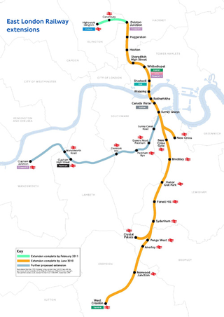
The East London line extension (ELLX) project was a British railway engineering project in London, managed by Transport for London. The project involved extending the East London Line and making it part of the mainline London Overground network. This was done by re-opening sections of disused railway line and by converting track electrified by the third-rail system, signalling, lineside signage and communication systems, etc. to mainline standards. New rolling stock was introduced and four new stations built along the route, with a fifth scheduled to be added in the future at New Bermondsey.

<span class="mw-page-title-main">West London Orbital</span> Proposed rail line in England

The West London Orbital is a proposed extension to the London Overground railway system. The extension would make use of a combination of existing freight and passenger lines including the Dudding Hill Line, North London Line and Hounslow Loop. The route would run for approximately 11 miles (17 km) from West Hampstead and Hendon at the northern end to Hounslow at the western end via Brent Cross West, Neasden, Harlesden, Old Oak Common, South Acton and Brentford.

Public transport in the London Borough of Havering, in east London, England, is a mix of National Rail, London Underground, London Overground and Crossrail and London Buses services. Rail services are primarily radial to central London with bus services providing most of the orbital connections. The public transport authority is Transport for London and the local authority is Havering London Borough Council.

References

  1. "Geographical map of London Overground 2010". Transport for London. November 2007. Archived from the original on 29 February 2008.
  2. "Final agreement and funding package". TfL. Archived from the original on 17 March 2009.
  3. "London Overground Clapham Junction to Surrey Quays" (Press release). Transport for London. Archived from the original on 16 May 2010.
  4. "Getting Londoners Moving" (PDF). Boris Johnson mayoral election campaign. 2008. Archived (PDF) from the original on 23 April 2010.
  5. Dudman, Jane (1 August 2014). "Boris Johnson's London orbital railway – is it a good idea?". The Guardian .