
Upwood is a village and former civil parish, now in the parish of Upwood and the Raveleys, in the non-metropolitan district and historic county of Huntingdonshire, England, although in the administrative county of Cambridgeshire. Upwood lies approximately 7 miles (11 km) north of Huntingdon, near Bury. In 1931 the parish had a population of 322.

Barrington is a small village and civil parish in the South Cambridgeshire district of Cambridgeshire, England. The village is about 7 miles (11 km) south-west of Cambridge, between Haslingfield and Shepreth.

Great Eversden is a village 6 miles south-west of Cambridge, England. The population of the civil parish at the 2011 Census was 241. The Prime Meridian runs through the parish just to the east of the village, separating it from Little Eversden.
Harlton is a village and civil parish in Cambridgeshire in the United Kingdom. The village is 5 miles (8.0 km) south-west of Cambridge and neighbours Haslingfield.

Steeple Morden is a village and civil parish in Cambridgeshire, England, about 15 miles (24 km) south west of Cambridge and 5 miles (8 km) west of Royston. It is part of the South Cambridgeshire local government district.
Great Chishill is a village and former civil parish, now in the parish of Great and Little Chishill, in the South Cambridgeshire district, in the county of Cambridgeshire, England. The village is about 1 mile (1.6 km) east of the county boundary with Hertfordshire and about 4 miles (6 km) east of Royston. In 1961 the parish had a population of 293. The 2011 Census recorded Great and Little Chishill's population as 678.
Whaddon is a village and civil parish in South Cambridgeshire, England, 6 kilometres (3.7 mi) north of Royston.

Holy Cross Church is a redundant Anglican church in the village of Burley, Rutland, England. It is recorded in the National Heritage List for England as a designated Grade II* listed building, and is under the care of the Churches Conservation Trust. It stands adjacent to Burley-on-the-Hill House.

The Church of St Mary and All Saints is an Anglican church in the village of Whalley, Lancashire, England. It is an active parish church in the Diocese of Blackburn. A church probably existed on the site in Anglo-Saxon times and the current building dates from the 13th century. It is recorded in the National Heritage List for England as a designated Grade I listed building.

St John's Church is a redundant Anglican church in the village of Duxford, Cambridgeshire, England. In 1967 it was recorded in the National Heritage List for England as a designated Grade I listed building, and is now vested in The Churches Conservation Trust. The church stands on the junction of St John's Street and Green Street and is open daily to visitors.
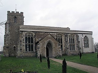
St Michael's Church is a redundant Anglican church in the village of Longstanton, Cambridgeshire, England. It is recorded in the National Heritage List for England as a designated Grade II* listed building, and is under the care of the Churches Conservation Trust. The church stands at the south end of the village. The design of St Michael's was used for that of the Church of St. James the Less in Philadelphia, Pennsylvania, as well as St. Thomas Church in New Windsor, New York, both in 1846. It has been influential in the design of other churches in the American Gothic Revival style.
St Andrew's Church is a redundant Anglican church in the village of Buckland, Hertfordshire, England. It is recorded in the National Heritage List for England as a designated Grade II* listed building, and is under the care of the Churches Conservation Trust. The church stands at the highest point in the village to the east of Ermine Street, now the A10 road, between Royston and Buntingford.

St Margaret's Church is a historic Anglican church in the village of Abbotsley, Cambridgeshire, England. It is recorded in the National Heritage List for England as a designated Grade II* listed building, and is under the care of The Churches Conservation Trust. The church stands in the centre of the village, to the south of the B1046 road.

St John the Baptist's Church is a redundant Anglican church in the village of Parson Drove, Cambridgeshire, England. It is recorded in the National Heritage List for England as a designated Grade II* listed building, and is under the care of the Churches Conservation Trust. The church stands at the east end of the village, on the north side of the B1169 road, some 6 miles (10 km) west of Wisbech.

Old St Peter and St Paul's Church is a former Anglican church near the village of Albury, Surrey, England in the care of The Churches Conservation Trust. It is recorded in the National Heritage List for England as a designated Grade I listed building. The church stands in Albury Park, to the northwest of Albury Hall, and between the villages of Albury and Shere.

St James the Great Church is a Grade I listed Church of England parish church dedicated to James, son of Zebedee in Aslackby, Lincolnshire, England. The church is 7 miles (11 km) north from Bourne, and in the Aslackby and Laughton parish on the eastern edge the South Kesteven Lincolnshire Vales.
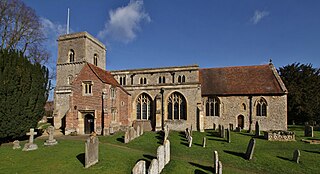
The Church of All Saints, Sutton Courtenay is the Church of England parish church of Sutton Courtenay, England. Extant since at least the 12th century, the church has been Grade I listed since 1966. It is in the centre of the village, near the northeast corner of the village green.

St Mary Magdalene Church is the Church of England parish church in the village of Ickleton in Cambridgeshire. The church is a Grade I listed building. Its parish is part of a combined benefice with those of St Peter's, Duxford and SS Mary and John, Hinxton.

The Church of St Mary the Virgin is the parish church for the village of Gamlingay in Cambridgeshire and is dedicated to St Mary the Virgin. Gamlingay is part of the ecclesiastical parish of Gamlingay with Hatley St George and East Hatley. The church is mainly 13th-century with extensive rebuilding in the 14th and 15th centuries. It has been a Grade I listed building since 1967 and comes under the St Neots Deanery in the Diocese of Ely. Nikolaus Pevsner in 1954 described the church as "... the most impressive church in this part of the county."
St Andrew's Church, Chesterton is a Church of England parish church in Chesterton, Cambridge. It is a Grade I listed building. A church was first recorded on this site around 1200. The church was presented in 1217 to the papal legate, Cardinal Guala, by Henry III of England, in gratitude for the legate's attempt at reconciliation during domestic unrest at the end of the reign of King John. In 1436 Henry VI seized ownership of the church and associated buildings from the Italian Abbey of Vercelli and gave it to King's Hall, Cambridge which later became Trinity College, Cambridge. Trinity College is the church's patron to this day; with many vicars of Chesterton being fellows of Trinity.


