
Lowestoft is a coastal town and civil parish in the East Suffolk district of Suffolk, England. As the most easterly UK settlement, it is 110 miles (177 km) north-east of London, 38 miles (61 km) north-east of Ipswich and 22 miles (35 km) south-east of Norwich, and the main town in its district. The estimated population in the built-up area exceeds 70,000. Its development grew with the fishing industry and as a seaside resort with wide sandy beaches. As fishing declined, oil and gas exploitation in the North Sea in the 1960s took over. While these too have declined, Lowestoft is becoming a regional centre of the renewable energy industry.
Oulton Broad refers to both the lake and the suburb of Lowestoft in the English county of Suffolk.

The East Suffolk line is an un-electrified 49-mile secondary railway line running between Ipswich and Lowestoft in Suffolk, England. The traffic along the route consists of passenger services operated by Greater Anglia, while nuclear flask trains for the Sizewell nuclear power stations are operated by Direct Rail Services.
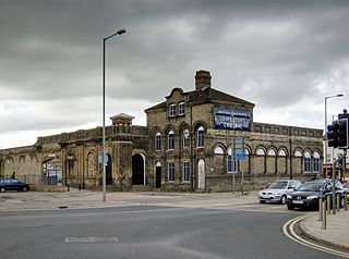
Lowestoft railway station serves the town of Lowestoft, Suffolk. It is the eastern terminus of the East Suffolk Line from Ipswich and is one of two eastern termini of the Wherry Lines from Norwich. Lowestoft is 23 miles 41 chains (37.8 km) down the line from Norwich and 48 miles 75 chains (78.8 km) measured from Ipswich; it is the easternmost station on the National Rail network in the United Kingdom.

Oulton Broad North railway station (originally opened as Mutford and later known as Oulton Broad (Mutford) and Oulton Broad) is on the Wherry Lines in the east of England, and is one of two stations serving Oulton Broad, Suffolk. The other is Oulton Broad South on the East Suffolk Line. Oulton Broad North is 22 miles 4 chains (35.5 km) down the line from Norwich on the route to Lowestoft. The East Suffolk Line runs between Lowestoft and Ipswich.

Beccles railway station is on the East Suffolk Line in the east of England, serving the town of Beccles, Suffolk. It is 40 miles 34 chains (65.1 km) down the line from Ipswich and 109 miles 11 chains (175.6 km) measured from London Liverpool Street; it is situated between Brampton and Oulton Broad South stations. Its three-letter station code is BCC.

Westerfield railway station is on a branch line off the Great Eastern Main Line, in the East of England, serving the village of Westerfield, Suffolk. It is 3 miles 41 chains (5.7 km) down the line from Ipswich and 72 miles 25 chains (116.4 km) measured from London Liverpool Street. It is situated at a junction of the Felixstowe Branch Line to Felixstowe and the East Suffolk Line to Lowestoft. Its three-letter station code is WFI.

Ipswich railway station is on the Great Eastern Main Line in the East of England, serving the town of Ipswich, Suffolk. It is 68 miles 59 chains (110.6 km) down the line from London Liverpool Street and, on the main line, it is situated between Manningtree to the south and Needham Market to the north.
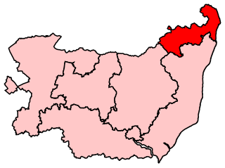
Waveney is a constituency represented in the House of Commons of the UK Parliament since 2010 by Peter Aldous, a Conservative. It returns one Member of Parliament (MP) to the House of Commons of the Parliament of the United Kingdom.

Carlton Colville is a civil parish and suburb of Lowestoft in the English county of Suffolk. It is 3 miles (5 km) south-west of the centre of the town, in the East Suffolk district. The area lies along the A146 Lowestoft to Beccles road.
Barnby is a village and civil parish in the East Suffolk district of the English county of Suffolk. The village is 5 miles (8.0 km) west of Lowestoft and 3 miles (4.8 km) east of Beccles in the north of the county. It is effectively merged with the village of North Cove which constitutes a separate parish.

The A146 is an A road that connects Norwich in Norfolk and Lowestoft in Suffolk, two of East Anglia's largest population centres. It is around 27 miles (43 km) in length and has primary classification along its entire route. It is mainly single carriageway throughout its route, with the exception of a section of dual carriageway on the southern edge of Norwich.

The Waveney Valley line was a branch line running from Tivetshall in Norfolk to Beccles in Suffolk connecting the Great Eastern Main Line at Tivetshall with the East Suffolk line at Beccles. It provided services to Norwich, Great Yarmouth, Lowestoft, Ipswich and many other towns in Suffolk with additional services to London. It was named after the River Waveney which follows a similar route.

Yarmouth South Town, sometimes known as Yarmouth Southtown, was a railway station in Great Yarmouth, Norfolk, England. It was one of three major stations in the town; the others being Yarmouth Vauxhall and Yarmouth Beach, of which only the former remains.
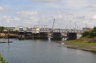
The Yarmouth–Lowestoft line was an East Anglian railway line which linked the coastal towns of Yarmouth, Gorleston-on-Sea and Lowestoft. It opened on 13 July 1903 as the first direct railway link between the two towns and was constructed by the Great Eastern Railway and the Midland and Great Northern Railway in the hope of encouraging the development of holiday resorts along the coast. In the event, although the line was built to high standards and considerable cost, intermediate traffic did not develop and competition from buses and trams eroded the little that had been generated. Fish traffic was carried in large quantities until the 1930s when it fell into decline. In 1953, when major repairs to the Breydon Viaduct were required, it was decided to discontinue through services from the Midland and Great Northern to Lowestoft and to divert London trains to Lowestoft via Norwich. After the Midland and Great Northern and Yarmouth–Beccles line closed to passengers in 1959, the Yarmouth–Lowestoft line was upgraded to accommodate the diverted traffic, but after services were switched to Yarmouth Vauxhall in 1962, it was singled and the stations made unstaffed halts. With only a local service running between vandalised stations, the decision was taken to close the route on 4 May 1970 in favour of bus services which were judged adequate for most of the year.
Mutford and Lothingland was a hundred of Suffolk, with an area of 33,368 acres (135.04 km2). Lowestoft Ness, the most easterly point of Great Britain fell within its bounds.
The East Anglian League was a football league in the East Anglia region of England.
The East Suffolk line is a railway in East Anglia with a long history.
