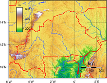
Burkina Faso is a landlocked country in West Africa with an area of 274,223 km2 (105,878 sq mi), bordered by Mali to the northwest, Niger to the northeast, Benin to the southeast, Togo and Ghana to the south, and Ivory Coast to the southwest. As of 2021, the country had an estimated population of 20,321,378. Previously called Republic of Upper Volta (1958–1984), it was renamed Burkina Faso by President Thomas Sankara. Its citizens are known as Burkinabè, and its capital and largest city is Ouagadougou.

Burkina Faso is a landlocked Sahel country that shares borders with six nations. It lies between the Sahara desert and the Gulf of Guinea, south of the loop of the Niger River, mostly between latitudes 9° and 15°N, and longitudes 6°W and 3°E. The land is green in the south, with forests and fruit trees, and semi-arid in the north. Most of central Burkina Faso lies on a savanna plateau, 198–305 metres (650–1,001 ft) above sea level, with fields, brush, and scattered trees. Burkina Faso's game preserves – the most important of which are Arly, Nazinga, and W National Park—contain lions, elephants, hippopotamus, monkeys, common warthogs, and antelopes. Previously the endangered painted hunting dog, Lycaon pictus occurred in Burkina Faso, but, although the last sightings were made in Arli National Park, the species is considered extirpated from Burkina Faso.

Transport in Burkina Faso consists primarily of road, air and rail transportation. The World Bank classified country's transportation as underdeveloped but noted that Burkina Faso is a natural geographic transportation hub for West Africa.

Ivory Coast invested remarkably in its transport system. Transport Infrastructures are much more developed than they are other West African countries despite a crisis that restrained their maintenance and development. Since its independence in 1960, Ivory Coast put an emphasis on increasing and modernizing the transport network for human as well as for goods. Major infrastructures of diverse nature were built including railways, roads, waterways, and airports. In spite of the crisis, neighbor countries still strongly depend on the Ivorian transport network for importing, exporting, and transiting their immigrants to Ivory Coast.

Dyula is a language of the Mande language family spoken mainly in Burkina Faso, Ivory Coast and Mali, and also in some other countries, including Ghana, Guinea and Guinea-Bissau. It is one of the Manding languages and is most closely related to Bambara, being mutually intelligible with Bambara as well as Malinke. It is a trade language in West Africa and is spoken by millions of people, either as a first or second language. Similar to the other Mande languages, it uses tones. It may be written in the Latin, Arabic or N'Ko scripts.

Mooré, also called More or Mossi, is a Gur language of the Oti–Volta branch and one of four official regional languages of Burkina Faso. It is the language of the Mossi people, spoken by approximately 6.46 million people in Burkina Faso, Ghana, Cote d’Ivoire, Benin, Niger, Mali, Togo and Senegal as a native language, but with many more L2 speakers. Mooré is spoken as a first or second language by over 50% of the Burkinabè population and is the main language in the capital city of Ouagadougou. It is one of the official regional languages in Burkina Faso and is closely related to Dagbani.

The Agacher Strip War or Christmas War was a war fought by Burkina Faso and Mali over a 160-kilometre-long (100 mi) strip of land along the border in northern Burkina Faso from 25 to 30 December 1985. The war ended in a ceasefire. The Agacher Strip had been subject to a border dispute between Mali and Burkina Faso since the 1960s. Following armed clashes in 1974, both countries agreed to mediation to resolve their differences. Progress on a solution stalled, and in 1983 Burkinabé President Thomas Sankara and Malian President Moussa Traoré decided to have the border dispute settled by the International Court of Justice and subsequently petitioned the body to resolve the issue.

The individual member states of the African Union (AU) coordinate foreign policy through this agency, in addition to conducting their own international relations on a state-by-state basis. The AU represents the interests of African peoples at large in intergovernmental organizations (IGO's); for instance, it is a permanent observer at the United Nations' General Assembly.

The Central Bank of West African States is a central bank serving the eight west African countries which share the common West African CFA franc currency and comprise the West African Economic and Monetary Union.

The Trans-Sahelian Highway or TAH 5 is a transnational highway project to pave, improve and ease border formalities on a highway route through the southern fringes of the Sahel region in West Africa between Dakar, Senegal in the west and Ndjamena, Chad, in the east. Alternative names for the highway are the Dakar-Ndjamena Highway or Ndjamena-Dakar Highway and it is Trans-African Highway 5 in the Trans-African Highway network.
The following outline is provided as an overview of and topical guide to Benin:

The following outline is provided as an overview of and topical guide to Ivory Coast:
The following outline is provided as an overview of and topical guide to Ghana:

The following outline is provided as an overview of and topical guide to Mali:
The following outline is provided as an overview of and topical guide to Niger:

The following outline is provided as an overview of and topical guide to Togo:

There are 622 kilometres of 1,000 mmmetre gauge railway in Burkina Faso, which run from Kaya to the border with Côte d'Ivoire and is part of the Abidjan-Ouagadougou railway. As of June 2014, 'Sitarail' operates a passenger train three times a week along the route from Ouagadougou to Abidjan. Journey time is 43 to 48 hours.
Atlantic Bank Group, commonly known by its French name Groupe Banque Atlantique, is a West African financial services conglomerate, headquartered in Lomé, Togo. The Group consisting of banks and other financial services companies in Cote d'Ivoire, Benin, Niger, Burkina Faso, Mali, Togo, Senegal and Cameroon.

The Burkina Faso–Niger border is 622 km in length and runs from the tripoint with Mali in the north to the tripoint with Benin in the south.