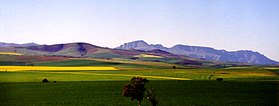
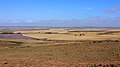
Typical summer (dry season) Overberg landscape with the Babilonstoring Mountains beyond between Caledon and Bot RiverOverberg in the early spring with canola fields in the foreground and Riviersonderend Mountains in the backgroundMap of the Overberg
The area has always been considered as the breadbasket of the Cape and is largely given to grain farming — mainly wheat. The wheat fields are a major breeding ground for South Africa's national bird, the blue crane. Another important crop in the Overberg is fruit, with the Elgin Valley producing about 60 percent of the total annual apple crop of about 819 000 tonnes (2012 data).[1]
Nestled in the Overberg, one can find the Kogelberg Biosphere Reserve (recognised and registered with UNESCO) populated with a large diversity of flowering plants not found anywhere else in the fynbosbiome.
The major towns are Hermanus, Caledon, Bredasdorp, Grabouw and Swellendam and the region includes Cape Agulhas, the southernmost point of Africa. The landscape is dominated by gently to moderately undulating hills enclosed by mountains and the ocean.
The name, derived from Over 't Berg, means "over the (Hottentots-Holland) mountain" and is a reference to the region's location relative to Cape Town.[2]
History
Overberg was explored by Dutch pastoralists who transported ox wagons back to Cape Town through the Hottentots Holland Mountains as early as 1663. Currently, its names in toponymy have combined to rivers and mountains and exist to the present day.
Overberg gallery
See also
Swellendam– Town in Western Cape, South Africa, once the capital of the Overberg.
Struisbaai– Coastal town in Western Cape, South Africa
Cape Agulhas is a rocky headland in Western Cape, South Africa. It is the geographic southern tip of the African continent and the beginning of the dividing line between the Atlantic and Indian Oceans according to the International Hydrographic Organization.
Swellendam Municipality is a municipality located in the Western Cape Province of South Africa. As of 2011 it had a population of 35,916. Its municipality code is WC034.
Theewaterskloof Municipality is a local municipality located within the Overberg District Municipality, in the Western Cape province of South Africa. As of 2007, the population was 108,790. Its municipality code is WC031. The enormous Theewaterskloof Dam, which provides water for Cape Town and the surrounding areas, is located in this municipality.
Swellendam is the fifth oldest town in South Africa, a town with 17,537 inhabitants situated in the Western Cape province. The town has over 50 provincial heritage sites, most of them buildings of Cape Dutch architecture. Swellendam is situated on the N2, approximately 220 km from both Cape Town and George.
The Overberg District Municipality is a district municipality that governs the Overberg region in the Western Cape province of South Africa. It is divided into four local municipalities and includes the major towns of Grabouw, Caledon, Hermanus, Bredasdorp and Swellendam. The municipal area covers 12,241 square kilometres (4,726 sq mi) and had in 2007 an estimated population of 212,787 people in 60,056 households.
The Langeberg Range is a mountain range in the Western Cape province of South Africa. Its highest peak is Keeromsberg at 2,075 m that lies 15 km northeast of the town of Worcester. Some of the highest peaks of the range are located just to the north of Swellendam, in a subrange known as the Clock Peaks whose highest point is the 1,710 m high Misty Point. Local lore states one can tell the time by means of the shadows cast by the seven summits of the Clock Peaks.
Heidelberg is a town in the Western Cape, South Africa. It is located near South Africa's south coast, on the N2 highway, 274 km east of Cape Town. Heidelberg is just east of the Overberg region, and some consider it the beginning of the Garden Route. Heidelberg is part of the Hessequa Local Municipality. Fourie House on Fourie Street is the oldest house in Heidelberg.
Barrydale is a village located on the border of the Overberg and Klein Karoo regions of the Western Cape Province in South Africa. It was named after Joseph Barry, a well known merchant of the 19th century. It is situated at the northern end of the Tradouw's pass which winds its way through the mountains to Swellendam.
Helderberg refers to a planning district of the City of Cape Town metropolitan municipality, the mountain after which it is named, a wine-producing area in the Western Cape province of South Africa, or a small census area in Somerset West.
Elgin is a large, lush area of land, circled by mountains, in the Overberg region of South Africa. This broad upland valley lies about 70 km southeast of Cape Town, just beyond the Hottentots Holland Mountains.
Caledon is a town in the Overberg region in the Western Cape province of South Africa, located about 100 kilometres (62 mi) east of Cape Town next to mineral-rich hot springs. As of 2011 it had a population of 13,020. It is located in, and the seat of, the Theewaterskloof Local Municipality.
Bredasdorp is a town in the Southern Overberg region of the Western Cape, South Africa, and the main economic and service hub of that region. It lies on the northern edge of the Agulhas Plain, about 160 kilometres (100 mi) south-east of Cape Town and 35 kilometres (22 mi) north of Cape Agulhas, the southernmost tip of Africa.
The Hottentots Holland Mountains are part of the Cape Fold Belt in the Western Cape, South Africa. The mountain range forms a barrier between the Cape Town metropolitan area and the southern Overberg coast.
Grabouw is a town located in the Western Cape province of South Africa. Grabouw is located some 65 km south-east of Cape Town, over Sir Lowry's Pass from Somerset West, along the N2 highway.The town is the commercial centre for the vast Elgin Valley, the largest single export fruit-producing area in Southern Africa, which extends between the Hottentots-Holland, Kogelberg, Groenland, and Houwhoek Mountains. The town's population has grown rapidly, with 44 593 people in 2019 from 21 593 as listed by the 2001 census.
The wine regions of South Africa were defined under the "Wine of Origin" act of 1973. Mirroring the French Appellation d'origine contrôlée (AOC) system, all South African wines listing a "Wine of Origin" must be composed entirely of grapes from its region. The "Wine of Origins" (WO) program mandates how wine regions of South Africa are defined and can appear on wine labels. While some aspects of the WO are taken from the AOC, the WO is primarily concerned with accuracy in labeling. As a result, the WO does not place adjunct regulations on wine regions such as delineating permitted varieties, trellising methods, irrigation techniques, and crop yields.
The Overberg branch line is a railway line in the Western Cape, South Africa. It runs from Cape Town through Somerset West and Caledon to Bredasdorp.
Kogelberg Nature Reserve is a nature reserve of 3,000 ha comprising the Kogelberg Mountain Range, to the east of Cape Town, South Africa.
The Boland is a region of the Western Cape province of South Africa, situated to the northeast of Cape Town in the middle and upper courses of the Berg and Breede Rivers, around the Boland Mountains of the central Cape Fold Belt. It is sometimes also referred to as the Cape Winelands because it is the primary region for the making of Western Cape wine.
The Groenland is a small mountain range in the Western Cape, South Africa, and forms part of the Cape Fold Belt.
Grootvadersbosch is a historic farm in the Overberg, and the surrounding area is currently a nature reserve in the southern portion of the Boosmansbos Wilderness Area, in Western Cape, South Africa.
This page is based on this Wikipedia article Text is available under the CC BY-SA 4.0 license; additional terms may apply. Images, videos and audio are available under their respective licenses.