
In meteorology, a cloud is an aerosol consisting of a visible mass of miniature liquid droplets, frozen crystals, or other particles suspended in the atmosphere of a planetary body or similar space. Water or various other chemicals may compose the droplets and crystals. On Earth, clouds are formed as a result of saturation of the air when it is cooled to its dew point, or when it gains sufficient moisture from an adjacent source to raise the dew point to the ambient temperature.
Diamond dust is a ground-level cloud composed of tiny ice crystals. This meteorological phenomenon is also referred to simply as ice crystals and is reported in the METAR code as IC. Diamond dust generally forms under otherwise clear or nearly clear skies, so it is sometimes referred to as clear-sky precipitation. Diamond dust is most commonly observed in Antarctica and the Arctic, but can occur anywhere with a temperature well below freezing. In the polar regions of Earth, diamond dust may persist for several days without interruption.

A stratocumulus cloud, occasionally called a cumulostratus, belongs to a genus-type of clouds characterized by large dark, rounded masses, usually in groups, lines, or waves, the individual elements being larger than those in altocumulus, and the whole being at a lower height, usually below 2,000 metres (6,600 ft). Weak convective currents create shallow cloud layers because of drier, stable air above preventing continued vertical development. Historically, in English, this type of cloud has been referred to as a twain cloud for being a combination of two types of clouds.

Cirrostratus is a high-altitude, very thin, generally uniform stratiform genus-type of cloud. It is made out of ice-crystals, which are pieces of frozen water. It is difficult to detect and it can make halos. These are made when the cloud takes the form of thin cirrostratus nebulosus. The cloud has a fibrous texture with no halos if it is thicker cirrostratus fibratus. On the approach of a frontal system, the cirrostratus often begins as nebulous and turns to fibratus. If the cirrostratus begins as fragmented of clouds in the sky it often means the front is weak. Cirrostratus is usually located above 5.5 km (18,000 ft). Its presence indicates a large amount of moisture in the upper troposphere. Clouds resembling cirrostratus occasionally form in polar regions of the lower stratosphere. Polar stratospheric clouds can take on this appearance when composed of tiny supercooled droplets of water or nitric acid.
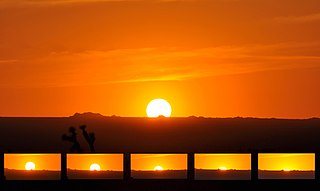
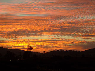
Sunset is the disappearance of the Sun below the horizon of the Earth due to its rotation. As viewed from everywhere on Earth, it is a phenomenon that happens approximately once every 24 hours, except in areas close to the poles. The equinox Sun sets due west at the moment of both the spring and autumn equinoxes. As viewed from the Northern Hemisphere, the Sun sets to the northwest in the spring and summer, and to the southwest in the autumn and winter; these seasons are reversed for the Southern Hemisphere.

The sky is an unobstructed view upward from the surface of the Earth. It includes the atmosphere and outer space. It may also be considered a place between the ground and outer space, thus distinct from outer space.
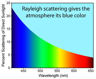
Diffuse sky radiation is solar radiation reaching the Earth's surface after having been scattered from the direct solar beam by molecules or particulates in the atmosphere. It is also called sky radiation, the determinative process for changing the colors of the sky. Approximately 23% of direct incident radiation of total sunlight is removed from the direct solar beam by scattering into the atmosphere; of this amount about two-thirds ultimately reaches the earth as photon diffused skylight radiation.
METAR is a format for reporting weather information. A METAR weather report is predominantly used by aircraft pilots, and by meteorologists, who use aggregated METAR information to assist in weather forecasting.

In meteorology, the synoptic scale is a horizontal length scale of the order of 1,000 km (620 mi) or more. This corresponds to a horizontal scale typical of mid-latitude depressions. Most high- and low-pressure areas seen on weather maps are synoptic-scale systems, driven by the location of Rossby waves in their respective hemisphere. Low-pressure areas and their related frontal zones occur on the leading edge of a trough within the Rossby wave pattern, while high-pressure areas form on the back edge of the trough. Most precipitation areas occur near frontal zones. The word synoptic is derived from the Ancient Greek word συνοπτικός (sunoptikós), meaning "seen together".

Whiteout, white-out, or milky weather is a weather condition in which the contours and landmarks in a snow-covered zone become almost indistinguishable. It could be also applied when visibility and contours are greatly reduced by sand. The horizon disappears from view while the sky and landscape appear featureless, leaving no points of visual reference by which to navigate; there is absence of shadows because the light arrives in equal measure from all possible directions. Whiteout has been defined as: "A condition of diffuse light when no shadows are cast, due to a continuous white cloud layer appearing to merge with the white snow surface. No surface irregularities of the snow are visible, but a dark object may be clearly seen. There is no visible horizon."

New England's Dark Day occurred on May 19, 1780, when an unusual darkening of the daytime sky was observed over the New England states and parts of eastern Canada. The primary cause of the event is believed to have been a combination of smoke from forest fires, a thick fog, and cloud cover. The darkness was so complete that candles were required from noon on. It did not disperse until the middle of the next night.
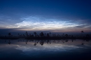
Noctilucent clouds, or night shining clouds, are tenuous cloud-like phenomena in the upper atmosphere of Earth. When viewed from space, they are called polar mesospheric clouds (PMCs), detectable as a diffuse scattering layer of water ice crystals near the summer polar mesopause. They consist of ice crystals and from the ground are only visible during astronomical twilight. Noctilucent roughly means "night shining" in Latin. They are most often observed during the summer months from latitudes between ±50° and ±70°. Too faint to be seen in daylight, they are visible only when the observer and the lower layers of the atmosphere are in Earth's shadow, but while these very high clouds are still in sunlight. Recent studies suggest that increased atmospheric methane emissions produce additional water vapor once the methane molecules reach the mesosphere – creating, or reinforcing existing noctilucent clouds.

June Gloom is a mainly Southern California term for a weather pattern that results in cloudy, overcast skies with cool temperatures during the late spring and early summer. While it is most common in the month of June, it can occur in surrounding months, giving rise to other colloquialisms, such as “Graypril,” "May Gray," "No-Sky July," and "Fogust." Low-altitude stratus clouds form over the cool water of the California Current, and spread overnight into the coastal regions of California.
Gloom is a low level of light which is so dim that there are physiological and psychological effects. Human vision at this level becomes monochrome and has lessened clarity.

The eye is a region of mostly calm weather at the center of a tropical cyclone. The eye of a storm is a roughly circular area, typically 30–65 kilometers in diameter. It is surrounded by the eyewall, a ring of towering thunderstorms where the most severe weather and highest winds of the cyclone occur. The cyclone's lowest barometric pressure occurs in the eye and can be as much as 15 percent lower than the pressure outside the storm.

In meteorology, an okta is a unit of measurement used to describe the amount of cloud cover at any given location such as a weather station. Sky conditions are estimated in terms of how many eighths of the sky are covered in cloud, ranging from 0 oktas through to 8 oktas. In addition, in the SYNOP code there is an extra cloud cover indicator '9' indicating that the sky is totally obscured, usually due to dense fog or heavy snow.

Hemispherical photography, also known as canopy photography, is a technique to estimate solar radiation and characterize plant canopy geometry using photographs taken looking upward through an extreme wide-angle lens or a fisheye lens. Typically, the viewing angle approaches or equals 180-degrees, such that all sky directions are simultaneously visible. The resulting photographs record the geometry of visible sky, or conversely the geometry of sky obstruction by plant canopies or other near-ground features. This geometry can be measured precisely and used to calculate solar radiation transmitted through plant canopies, as well as to estimate aspects of canopy structure such as leaf area index. Detailed treatments of field and analytical methodology have been provided by Paul Rich and Robert Pearcy (1989).

Airport weather stations are automated sensor suites which are designed to serve aviation and meteorological operations, weather forecasting and climatology. Automated airport weather stations have become part of the backbone of weather observing in the United States and Canada and are becoming increasingly more prevalent worldwide due to their efficiency and cost-savings.
In aviation, ceiling is a measurement of the height of the base of the lowest clouds that cover more than half of the sky relative to the ground. Ceiling is not specifically reported as part of the METAR used for flight planning by pilots worldwide, but can be deduced from the lowest height with broken (BKN) or overcast (OVC) reported. A ceiling listed as "unlimited" means either that the sky is mostly free of cloud cover, or that the cloud is high enough not to impede Visual Flight Rules (VFR) operation.
Atmospheric optics is "the study of the optical characteristics of the atmosphere or products of atmospheric processes .... [including] temporal and spatial resolutions beyond those discernible with the naked eye". Meteorological optics is "that part of atmospheric optics concerned with the study of patterns observable with the naked eye". Nevertheless, the two terms are sometimes used interchangeably.
