Related Research Articles

Clouds and the Earth's Radiant Energy System (CERES) is on-going NASA climatological experiment from Earth orbit. The CERES are scientific satellite instruments, part of the NASA's Earth Observing System (EOS), designed to measure both solar-reflected and Earth-emitted radiation from the top of the atmosphere (TOA) to the Earth's surface. Cloud properties are determined using simultaneous measurements by other EOS instruments such as the Moderate Resolution Imaging Spectroradiometer (MODIS). Results from the CERES and other NASA missions, such as the Earth Radiation Budget Experiment (ERBE), could enable nearer to real-time tracking of Earth's energy imbalance and better understanding of the role of clouds in global climate change.
The Earth Observing System (EOS) is a program of NASA comprising a series of artificial satellite missions and scientific instruments in Earth orbit designed for long-term global observations of the land surface, biosphere, atmosphere, and oceans. Since the early 1970s, NASA has been developing its Earth Observing System, launching a series of Landsat satellites in the decade. Some of the first included passive microwave imaging in 1972 through the Nimbus 5 satellite. Following the launch of various satellite missions, the conception of the program began in the late 1980s and expanded rapidly through the 1990s. Since the inception of the program, it has continued to develop, including; land, sea, radiation and atmosphere. Collected in a system known as EOSDIS, NASA uses this data in order to study the progression and changes in the biosphere of Earth. The main focus of this data collection surrounds climatic science. The program is the centrepiece of NASA's Earth Science Enterprise.
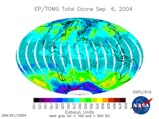
The Total Ozone Mapping Spectrometer (TOMS) was a NASA satellite instrument, specifically a spectrometer, for measuring the ozone layer. Of the five TOMS instruments which were built, four entered successful orbit. The satellites carrying TOMS instruments were:

The advanced microwave sounding unit (AMSU) is a multi-channel microwave radiometer installed on meteorological satellites. The instrument examines several bands of microwave radiation from the atmosphere to perform atmospheric sounding of temperature and moisture levels.

The National Polar-orbiting Operational Environmental Satellite System (NPOESS) was to be the United States' next-generation satellite system that would monitor the Earth's weather, atmosphere, oceans, land, and near-space environment. NPOESS satellites were to host proven technologies and operational versions of sensors that were under operational-prototyping by NASA, at that time. The estimated launch date for the first NPOESS satellite, "C1" or "Charlie 1" was around 2013. Issues with sensor developments were the primary cited reason for delays and cost-overruns.
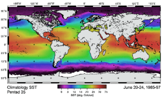
The Advanced Very-High-Resolution Radiometer (AVHRR) instrument is a space-borne sensor that measures the reflectance of the Earth in five spectral bands that are relatively wide by today's standards. AVHRR instruments are or have been carried by the National Oceanic and Atmospheric Administration (NOAA) family of polar orbiting platforms (POES) and European MetOp satellites. The instrument scans several channels; two are centered on the red (0.6 micrometres) and near-infrared (0.9 micrometres) regions, a third one is located around 3.5 micrometres, and another two the thermal radiation emitted by the planet, around 11 and 12 micrometres.

NOAA-19, known as NOAA-N' before launch, is the last of the American National Oceanic and Atmospheric Administration (NOAA) series of weather satellites. NOAA-19 was launched on 6 February 2009. NOAA-19 is in an afternoon Sun-synchronous orbit and is intended to replace NOAA-18 as the prime afternoon spacecraft.

Over the last two centuries many environmental chemical observations have been made from a variety of ground-based, airborne, and orbital platforms and deposited in databases. Many of these databases are publicly available. All of the instruments mentioned in this article give online public access to their data. These observations are critical in developing our understanding of the Earth's atmosphere and issues such as climate change, ozone depletion and air quality. Some of the external links provide repositories of many of these datasets in one place. For example, the Cambridge Atmospheric Chemical Database, is a large database in a uniform ASCII format. Each observation is augmented with the meteorological conditions such as the temperature, potential temperature, geopotential height, and equivalent PV latitude.

The ozone monitoring instrument (OMI) is a nadir-viewing visual and ultraviolet spectrometer aboard the NASA Aura spacecraft. Aura flies in formation about 15 minutes behind Aqua, both of which orbit the Earth in a polar Sun-synchronous pattern. Aura was launched on July 15, 2004, and OMI has collected data since August 9, 2004. OMI can distinguish between aerosol types, such as smoke, dust, and sulfates, and can measure cloud pressure and coverage, which provide data to derive tropospheric ozone. OMI follows in the heritage of TOMS, SBUV, GOME, SCIAMACHY, and GOMOS. OMI measurements cover a spectral region of 264–504 nm (nanometers) with a spectral resolution between 0.42 nm and 0.63 nm and a nominal ground footprint of 13 × 24 km2 at nadir. The Aura satellite orbits at an altitude of 705 km in a sun-synchronous polar orbit with an exact 16-day repeat cycle and with a local equator crossing time of 13. 45 on the ascending node. The orbital inclination is 98.1 degrees, providing latitudinal coverage from 82° N to 82° S. It is a wide-field-imaging spectrometer with a 114° across-track viewing angle range that provides a 2600 km wide swath, enabling measurements with a daily global coverage. OMI is continuing the TOMS record for total ozone and other atmospheric parameters related to ozone chemistry and climate.

NOAA-17, also known as NOAA-M before launch, was an operational, polar orbiting, weather satellite series operated by the National Environmental Satellite Service (NESS) of the National Oceanic and Atmospheric Administration (NOAA). NOAA-17 also continued the series of Advanced TIROS-N (ATN) spacecraft begun with the launch of NOAA-8 (NOAA-E) in 1983 but with additional new and improved instrumentation over the NOAA A-L series and a new launch vehicle.

NOAA-18, also known as NOAA-N before launch, is an operational, polar orbiting, weather satellite series operated by the National Environmental Satellite Service (NESS) of the National Oceanic and Atmospheric Administration (NOAA). NOAA-18 also continued the series of Advanced TIROS-N (ATN) spacecraft begun with the launch of NOAA-8 (NOAA-E) in 1983 but with additional new and improved instrumentation over the NOAA A-M series and a new launch vehicle. NOAA-18 is in an afternoon equator-crossing orbit and replaced NOAA-17 as the prime afternoon spacecraft.
The Polar-orbiting Operational Environmental Satellite (POES) was a constellation of polar orbiting weather satellites funded by the National Oceanic and Atmospheric Administration (NOAA) and the European Organisation for the Exploitation of Meteorological Satellites (EUMETSAT) with the intent of improving the accuracy and detail of weather analysis and forecasting. The spacecraft were provided by NASA and the European Space Agency (ESA), and NASA's Goddard Space Flight Center oversaw the manufacture, integration and test of the NASA-provided TIROS satellites. The first polar-orbiting weather satellite launched as part of the POES constellation was the Television Infrared Observation Satellite-N (TIROS-N), which was launched on 13 October 1978. The final spacecraft, NOAA-19, was launched on 6 February 2009. The ESA-provided MetOp satellite operated by EUMETSAT utilize POES-heritage instruments for the purpose of data continuity. The Joint Polar Satellite System, which was launched on 18 November 2017, is the successor to the POES Program.

The Solar Backscatter Ultraviolet Radiometer, or SBUV/2, is a series of operational remote sensors on NOAA weather satellites in Sun-synchronous orbits which have been providing global measurements of stratospheric total ozone, as well as ozone profiles, since March 1985. The SBUV/2 instruments were developed from the SBUV experiment flown on the Nimbus-7 spacecraft which improved on the design of the original BUV instrument on Nimbus-4. These are nadir viewing radiometric instruments operating at mid to near UV wavelengths. SBUV/2 data sets overlap with data from SBUV and TOMS instruments on the Nimbus-7 spacecraft. These extensive data sets measure the density and vertical distribution of ozone in the Earth's atmosphere from six to 30 miles.

ADEOS I was an Earth observation satellite launched by NASDA in 1996. The mission's Japanese name, Midori means "green". The mission ended in July 1997 after the satellite sustained structural damage to the solar panel. Its successor, ADEOS II, was launched in 2002. Like the first mission, it ended after less than a year, also following solar panel malfunctions.

The Joint Polar Satellite System (JPSS) is the latest generation of U.S. polar-orbiting, non-geosynchronous, environmental satellites. JPSS will provide the global environmental data used in numerical weather prediction models for forecasts, and scientific data used for climate monitoring. JPSS will aid in fulfilling the mission of the U.S. National Oceanic and Atmospheric Administration (NOAA), an agency of the Department of Commerce. Data and imagery obtained from the JPSS will increase timeliness and accuracy of public warnings and forecasts of climate and weather events, thus reducing the potential loss of human life and property and advancing the national economy. The JPSS is developed by the National Aeronautics and Space Administration (NASA) for the National Oceanic and Atmospheric Administration (NOAA), who is responsible for operation of JPSS. Three to five satellites are planned for the JPSS constellation of satellites. JPSS satellites will be flown, and the scientific data from JPSS will be processed, by the JPSS – Common Ground System (JPSS-CGS).

The Suomi National Polar-orbiting Partnership, previously known as the National Polar-orbiting Operational Environmental Satellite System Preparatory Project (NPP) and NPP-Bridge, is a weather satellite operated by the United States National Oceanic and Atmospheric Administration (NOAA). It was launched in 2011 and is currently in operation.

The Visible Infrared Imaging Radiometer Suite (VIIRS) is a sensor designed and manufactured by the Raytheon Company on board the polar-orbiting Suomi National Polar-orbiting Partnership, NOAA-20, and NOAA-21 weather satellites. VIIRS is one of five key instruments onboard Suomi NPP, launched on October 28, 2011. VIIRS is a whiskbroom scanner radiometer that collects imagery and radiometric measurements of the land, atmosphere, cryosphere, and oceans in the visible and infrared bands of the electromagnetic spectrum.

NOAA-21, designated JPSS-2 prior to launch, is the second of the United States National Oceanic and Atmospheric Administration (NOAA)'s latest generation of U.S. polar-orbiting, non-geosynchronous, environmental satellites called the Joint Polar Satellite System. NOAA-21 was launched on 10 November 2022 and join NOAA-20 and Suomi NPP in the same orbit. Circling the Earth from pole-to-pole, it will cross the equator about 14 times daily, providing full global coverage twice a day.
NOAA-20, designated JPSS-1 prior to launch, is the first of the United States National Oceanic and Atmospheric Administration's latest generation of U.S. polar-orbiting, non-geosynchronous, environmental satellites called the Joint Polar Satellite System. NOAA-20 was launched on 18 November 2017 and joined the Suomi National Polar-orbiting Partnership satellite in the same orbit. NOAA-20 operates about 50 minutes behind Suomi NPP, allowing important overlap in observational coverage. Circling the Earth from pole-to-pole, it crosses the equator about 14 times daily, providing full global coverage twice a day. This gives meteorologists information on "atmospheric temperature and moisture, clouds, sea-surface temperature, ocean color, sea ice cover, volcanic ash, and fire detection" so as to enhance weather forecasting including hurricane tracking, post-hurricane recovery by detailing storm damage and mapping of power outages.
The Advanced Technology Microwave Sounder (ATMS) is a 22-channel scanning microwave radiometer for observation of the Earth's atmosphere and surface. It is the successor to the Advanced Microwave Sounding Unit (AMSU) on NOAA weather satellites. ATMS units have been flown on the Suomi NPP and on the Joint Polar Satellite System.
References
- 1 2 3 "Ozone Mapping Profiler Suite (OMPS)". Joint Polar Satellite System. NASA. Archived from the original on 20 April 2018. Retrieved 7 August 2018.
- ↑ "Ozone Suite on Suomi NPP Continues More Than 30 Years of Ozone Data". NASA. 23 February 2012. Retrieved 7 August 2018.
- ↑ "Ozone Mapping and Profiler Suite (OMPS)". Joint Polar Satellite System. National Oceanic and Atmospheric Administration . Retrieved 7 August 2018.
- ↑ "Mission and Instruments". Joint Polar Satellite System. National Oceanographic and Atmospheric Agency. Retrieved 7 August 2018.