Pahaquarry Township, New Jersey

Last updated

Pahaquarry Township, New Jersey
Location map of Warren County, New Jersey.svg
Red pog.svg
Pahaquarry Township, New Jersey
Coordinates: 41°03′00″N75°01′59″W / 41.0500959°N 75.0329525°W / 41.0500959; -75.0329525 [1]
Country Flag of the United States.svg  United States
State Flag of New Jersey.svg  New Jersey
County Warren
Incorporated December 27, 1824
DissolvedJuly 2, 1997
Elevation
[1]
168 m (551 ft)
Time zone UTC-5
  Summer (DST) UTC-4 (Eastern (EDT))

Pahaquarry Township (pah-QUAR-ree) [2] was a township that was located in Warren County, New Jersey, United States, from 1824 until it was dissolved in 1997.

Contents

History

A view at Pahaquarric, Sussex County, New Jersey, engraved by John Scoles c. 1794 A view at Pahaquarric.jpg
A view at Pahaquarric, Sussex County, New Jersey, engraved by John Scoles c. 1794
Adit No. 1 at Pahaquarry Copper Mine, established c. 1750 Pahaquarry Copper Mine Adit 1.jpg
Adit No. 1 at Pahaquarry Copper Mine, established c. 1750

Pahaquarry Township was formed on December 27, 1824, from portions of Walpack Township in Sussex County and set off to Warren County. [3]

The township got its name from the word Pahaquarra, which was a derivation of the Native American word Pahaqualong, which meant "the place between the mountains beside the waters". [4]

Opened in the 1750s, the Pahaquarry Copper Mine was active from the 18th to early-20th centuries, until its closure in 1928. [5] Despite developments in mining technology and improving mineral extraction methods, the mine remained unsuccessful and unprofitable, as the ore extracted proved to be of too low a concentration of copper. [6]

Millbrook Village, located along the historic Old Mine Road in Pahaquarry, was home to the Van Campen family farmsteads built during the late-18th and 19th-centuries. In 1832, Abram Garis built a grist mill along Van Campen brook. The mill soon attracted other businesses and by the 1870s, Millbrook was a thriving farm village. However, by 1910, the mill, store and hotel closed their doors. The area is now part of the Delaware Water Gap National Recreation Area, and located within the Old Mine Road Historic District. Other buildings have been moved from other sites or are newly built to help depict village life in the valley during the late-19th and early-20th century. Several buildings are open to the public on summer weekends. [7]

Millbrook School, as seen August 1970 George A. Eisenman, Photographer August, 1970 SOUTHWEST AND SOUTHEAST (FRONT) ELEVATIONS - Millbrook Schoolhouse, Millbrook, Warren County, NJ HABS NJ,21-MILBRO.V,1-1.tif
Millbrook School, as seen August 1970

The Calno School was established in 1870, rebuilt in 1910, and active until the 1940, for schoolchildren of Pahaquarry. By 1881, the Calno school district counted 48 school-age pupils. Only 30 were on the school's register, though, and daily attendance averaged only 15. Teachers, who were paid poorly, boarded with local families and seldom stayed more than a year or two. Most students traveled to school on foot, and schools were placed so that students would not have to walk more than four to five miles. The Millbrook School, located 5 miles north in Millbrook Village, was used to teach Pahaquarry children, as well. [7] [8]

Pahaquarry sits on the Delaware River. Most of its land was purchased by the federal government during the late 1960s in order to build the proposed Tocks Island Dam along the river, and its population was reduced to only a handful of people. Grassroot environmental organizations and mass local opposition put a halt to these plans and the dam was never completed. [9] Most of the land became part of Delaware Water Gap National Recreation Area. The project was officially deauthorized by Congress during 1992. [4]

Millbrook Methodist Episcopal Church, as seen August 1970 George A. Eisenman August, 1970 NORTHEAST AND NORTHWEST (FRONT) ELEVATIONS - Millbrook Methodist Episcopal Church, Millbrook, Warren County, NJ HABS NJ,21-MILBRO,2-1.tif
Millbrook Methodist Episcopal Church, as seen August 1970

National attention was brought to Pahaquarry Township following a New York Times article published in April 1997. Mayor Jean Zipser and Harold Van Campen, the only members of the Township Committee, met inside the Calno School and voted 2-0 to permit the dissolution to proceed in March 1997. [2]

On July 2, 1997, Pahaquarry Township, whose population had dwindled to 6 people, [2] was dissolved and incorporated into Hardwick Township. [9]

Demographics

Historical population
CensusPop.Note
1830 258
1840 29213.2%
1850 46057.5%
1860 4651.1%
1870 405−12.9%
1880 4183.2%
1890 291−30.4%
1900 257−11.7%
1910 205−20.2%
1920 128−37.6%
1930 80−37.5%
1940 72−10.0%
1950 67−6.9%
1960 63−6.0%
1970 7112.7%
1980 26−63.4%
1990 20−23.1%
Population sources:
1830-1920 [10] 1840 [11] 1850 [12]
1870 [13] 1880-1890 [14]
1890-1910 [15] 1910-1930 [16]
1930-1990 [17]

As of the 1990 United States census (the last census for which the Township existed), there were 20 people, 9 households, and 5 families residing in the township. The racial makeup of the borough was 100.00% White (20 Whites). 5.00% of the population was Hispanic or Latino of any race (1 Hispanic or Latino).

In the township, the population was spread out, with 15.0% under the age of 18, 10.0% from 18 to 24, 20.0% from 25 to 44, 30.0% from 45 to 64, and 25.0% who were 65 years of age or older. The median age was 38 years.

See also

Related Research Articles

<span class="mw-page-title-main">Warren County, New Jersey</span> County in northwestern New Jersey, United States

Warren County is a county located in the U.S. state of New Jersey. According to the 2020 census, the county was the state's 19th-most populous county, with a population of 109,632, its highest decennial count ever and an increase of 940 (+0.9%) from the 2010 census count of 108,692, which in turn reflected an increase of 6,255 (+6.1%) from 102,437 counted at the 2000 census. The county is part of the North Jersey region of the state.

<span class="mw-page-title-main">Sussex County, New Jersey</span> County in New Jersey, United States

Sussex County is the northernmost county in the U.S. state of New Jersey. Its county seat is Newton. It is part of the New York metropolitan area and is part of New Jersey's Skylands Region. As of the 2020 census, the county was the state's 17th-most-populous county, with a population of 144,221, a decrease of 5,044 (−3.4%) from the 2010 census count of 149,265, which in turn reflected an increase of 5,099 (+3.5%) over the 144,166 persons at the 2000 census. Based on 2020 census data, Vernon Township was the county's largest in both population and area, with a population of 22,358 and covering an area of 70.59 square miles (182.8 km2). The county is part of the North Jersey region of the state.

<span class="mw-page-title-main">Hunterdon County, New Jersey</span> County in New Jersey, United States

Hunterdon County is a county located in the western section of the U.S. state of New Jersey. At the 2020 census, the county was the state's 18th-most populous county, with a population of 128,947, its highest decennial count ever and an increase of 598 (+0.5%) from the 2010 census count of 128,349, which in turn reflected an increase of 6,360 (5.2%) from the 121,989 counted in the 2000 census. Its county seat is Flemington. The county is part of the Central Jersey region of the state.

<span class="mw-page-title-main">Walpack Township, New Jersey</span> Township in Sussex County, New Jersey, United States

Walpack Township is a township in Sussex County, in the U.S. state of New Jersey. As of the 2020 United States census, the township's population was 7, a decrease of 9 (−56.3%) from the 2010 census count of 16, which in turn reflected a decline of 34 (−82.9%) from the 41 counted in the 2000 census. Walpack Township was the smallest municipality by population and one of only four municipalities in New Jersey with a population under 100 as of the 2020 Census; it had the state's third-smallest population in the 2010 census, behind Tavistock and the now-defunct Pine Valley, both in Camden County.

<span class="mw-page-title-main">Blairstown, New Jersey</span> Township in Warren County, New Jersey, United States

Blairstown is a township in Warren County, in the U.S. state of New Jersey. As of the 2020 United States census, the township's population was 5,704, a decrease of 263 (−4.4%) from the 2010 census count of 5,967, which in turn reflected an increase of 220 (+3.8%) from the 5,747 counted in the 2000 census.

<span class="mw-page-title-main">Hardwick Township, New Jersey</span> Township in Warren County, New Jersey, United States

Hardwick Township is a township in Warren County, in the U.S. state of New Jersey. As of the 2020 United States census, the township's population was 1,598, a decrease of 98 (−5.8%) from the 2010 census count of 1,696, which in turn reflected an increase of 232 (+15.8%) from the 1,464 counted in the 2000 census.

<span class="mw-page-title-main">Knowlton Township, New Jersey</span> Township in Warren County, New Jersey, United States

Knowlton Township is a township in Warren County, in the U.S. state of New Jersey. As of the 2020 United States census, the township's population was 2,894, a decrease of 161 (−5.3%) from the 2010 census count of 3,055, which in turn reflected an increase of 78 (+2.6%) from the 2,977 counted in the 2000 census.

<span class="mw-page-title-main">Pohatcong Township, New Jersey</span> Township in Warren County, New Jersey, US

Pohatcong Township is a township in Warren County, in the U.S. state of New Jersey. As of the 2020 United States census, the township's population was 3,241, a decrease of 98 (−2.9%) from the 2010 census count of 3,339, which in turn reflected a decline of 77 (−2.3%) from the 3,416 counted in the 2000 census.

<span class="mw-page-title-main">Delaware Water Gap</span> Geological feature along the Delaware River

Delaware Water Gap is a water gap on the border of the U.S. states of New Jersey and Pennsylvania where the Delaware River cuts through a large ridge of the Appalachian Mountains.

<span class="mw-page-title-main">Tocks Island Dam controversy</span>

A 1950s proposal to construct a dam near Tocks Island across the Delaware River was met with considerable controversy and protest. Tocks Island is located in the Delaware River a short distance north from the Delaware Water Gap. In order to control damaging flooding and provide clean water to supply New York City and Philadelphia, the U.S. Army Corps of Engineers proposed building a dam. When completed, the Tocks Island Dam would have created a 37-mile (60-km) long lake between Pennsylvania and New Jersey, with depths of up to 140 feet. This lake and the land surrounding were to be organized as the Tocks Island National Recreation Area. Although the dam was never built, 72,000 acres (291 km²) of land were acquired by condemnation and eminent domain. This incited environmental protesters and embittered local residents displaced by the project's preparations when their property was condemned. After the Tocks Island Dam project was withdrawn, the lands acquired were transferred to the oversight of the National Park Service which reorganized them to establish the Delaware Water Gap National Recreation Area.

<span class="mw-page-title-main">Kittatinny Mountain</span> Ridge in northwestern New Jersey

Kittatinny Mountain is a long ridge traversing primarily across Sussex County in northwestern New Jersey, running in a northeast-southwest axis, a continuation across the Delaware Water Gap of Pennsylvania's Blue Mountain. It is the first major ridge in the far northeastern extension of the Ridge and Valley province of the Appalachian Mountains, and reaches its highest elevation, 1,803 feet, at High Point in Montague Township. Kittatinny Mountain forms the eastern side of Wallpack Valley; the western side comprises the Wallpack Ridge (highest elevation: 928 feet above sea level.

Old Mine Road is a road in New Jersey and New York said to be one of the oldest continuously used roads in the United States of America. At a length of 104 miles (167 km), it stretches from the Delaware Water Gap National Recreation Area to the vicinity of Kingston, New York.

<span class="mw-page-title-main">Delaware, Warren County, New Jersey</span> Census-designated place in Middlesex County, New Jersey, US

Delaware is an unincorporated community and census-designated place (CDP) located along the Delaware River within Knowlton Township in Warren County, New Jersey. It was created as part of the 2010 United States Census. As of the 2010 Census, the CDP's population was 150. The area is served as United States Postal Service ZIP Code 07833.

<span class="mw-page-title-main">Pahaquarry Copper Mine</span> United States historic place

The Pahaquarry Copper Mine is an abandoned copper mine located on the west side of Kittatinny Mountain presently in Hardwick Township in Warren County, New Jersey in the United States. Active mining was attempted for brief periods during the mid-eighteenth, mid-nineteenth, and early twentieth centuries but was never successful despite developments in mining technology and improving mineral extraction methods. Such ventures were not profitable as the ore extracted proved to be of too low a concentration of copper. This site incorporates the mining ruins, hiking trails, and nearby waterfalls, and is located within the Delaware Water Gap National Recreation Area and administered by the National Park Service. It was added to the National Register of Historic Places in 1980 as a contributing property to the Old Mine Road Historic District.

<span class="mw-page-title-main">Van Campen's Inn</span> United States historic place

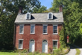
Van Campen's Inn or Isaac Van Campen Inn is a fieldstone residence that was used as a yaugh house during the American colonial era. Located in Walpack Township, Sussex County, New Jersey along the Delaware River, it is a historic site located along the Old Mine Road in the Delaware Water Gap National Recreation Area. It is operated under a memorandum of understanding between the National Park Service and the Walpack Historical Society, a local non-profit corporation.

<span class="mw-page-title-main">Wallpack Ridge</span>

Wallpack Ridge is a mountain located in the Ridge and Valley Appalachians physiographic province in Sussex County in northwestern New Jersey. Oriented northeast to southwest, Wallpack Ridge spans 25 miles (40 km) from Montague Township south of Port Jervis, New York to the Walpack Bend in the Delaware River near Flatbrookville in Walpack Township. It is a narrow ridge ranging between 0.67 miles (1.08 km) to 1.7 miles (2.7 km) in width, and its highest elevation reaches 928 feet (283 m) above sea level. The ridge separates the Wallpack Valley from the valley of the Delaware River, and contains the watershed of the Flat Brook and its main tributaries Big Flat Brook and Little Flat Brook.

<span class="mw-page-title-main">Wallpack Valley</span>

Wallpack Valley is a valley located in Sussex County in northwestern New Jersey formed by Wallpack Ridge on the west, and Kittatinny Mountain on the east. Wallpack Ridge separates the Wallpack Valley from the valley of the Delaware River, and contains the watershed of the Flat Brook and its main tributaries Big Flat Brook and Little Flat Brook. It is a narrow valley, roughly 25 miles (40 km) in length running from Montague Township south of Port Jervis, New York to the Walpack Bend in the Delaware River near Flatbrookville in Walpack Township where the Flat Brook enters the Delaware at 300 feet above sea level.

Yards Creek Generating Station is a pumped-storage hydroelectric plant in Blairstown and Hardwick Township in Warren County, New Jersey, United States. The facility is owned by REV Renewables, which purchased it from Public Service Enterprise Group and FirstEnergy in 2020 and 2021. It has an installed capacity of 420 MW.

<span class="mw-page-title-main">Millbrook, New Jersey</span> Populated place in Warren County, New Jersey, US

Millbrook, also known as Millbrook Village, is an unincorporated community located along Old Mine Road within Hardwick Township, formerly Pahaquarry Township, in Warren County, in the U.S. state of New Jersey. It is named after the Mill Brook, now known as Van Campens Mill Brook, a tributary of the Delaware River. The area is now part of the Delaware Water Gap National Recreation Area.

<span class="mw-page-title-main">Old Mine Road Historic District</span> Historic district in New Jersey, United States

The Old Mine Road Historic District is a 687-acre (278 ha) historic district located along Old Mine Road in Sussex County and Warren County, New Jersey. It is part of the Delaware Water Gap National Recreation Area. The district was added to the National Register of Historic Places on December 3, 1980, for its significance in agriculture, archaeology, architecture, commerce, exploration/settlement, and transportation. It includes 24 contributing buildings and five contributing sites.

References

  1. 1 2 U.S. Geological Survey Geographic Names Information System: Township of Pahaquarry (historical), Geographic Names Information System. Accessed June 13, 2013.
  2. 1 2 3 Chen, David W. "A New Jersey Township Votes Itself Nonexistent", The New York Times , April 28, 1997. Accessed December 18, 2022.
  3. Snyder, John P. The Story of New Jersey's Civil Boundaries: 1606-1968, Bureau of Geology and Topography; Trenton, New Jersey; 1969. p. 247. Accessed December 11, 2012.
  4. 1 2 Bewley, Joel. "Lost to merger, a town vanished Tiny Pahaquarry Township gave up in 1997.", The Philadelphia Inquirer , October 23, 2006. Accessed December 11, 2012. "Pahaquarry, a Lenni-Lenape word that means 'the place between the mountains beside the waters,' rested between the Delaware River and the Kittatinny Ridge.... It lost steam and funding and was finally deauthorized by Congress in 1992."
  5. "300 Year Old Copper Mine Too Expensive To Operate", The Morning Call , May 8, 1928. Accessed March 17, 2024, via Newspapers.com. "The final chapter In the history of a copper mine operated at Belvidere, N. J.. by the Dutch, as early, it is said, as 1630, is being written. The last of recently installed expensive mining machinery has been bought by a secondhand machinery and junk man, of Newark, and preparations are being made for its removal. The mine has lately been known as the Pahaquarry Copper Mine and in an effort to increase production and make the mine pay the latest type of mining machinery was installed."
  6. "The Dutch Mines: Fact or Myth?", Spanning the Gap newsletter of the Delaware Water Gap National Recreation Area, Summer 1988. Accessed March 17, 2024. "The copper ore at Pahaquarry is of very poor grade and is very diffuse in the rock. While it has teased along hope in three different centuries at least, in the end it has caused each successive mining operation to fail."
  7. 1 2 "Delaware Water Gap National Recreation Area: Scenic Drives". National Park Service. Millbrook Village
  8. Kopczynski, Susan. "A Ride Down Old Mine Road, Part I: Worthington State Forest to Watergate", National Park Service, October, 2012. Accessed December 18, 2022.
  9. 1 2 About Warren County...Past and Present, Warren County, New Jersey. Accessed September 28, 2006.
  10. Compendium of censuses 1726–1905: together with the tabulated returns of 1905 Archived 2014-06-29 at the Wayback Machine , New Jersey Department of State, 1906. Accessed June 5, 2013.
  11. Bowen, Francis. American Almanac and Repository of Useful Knowledge for the Year 1843, p. 231, David H. Williams, 1842. Accessed June 5, 2013.
  12. Debow, James Dunwoody Brownson. The Seventh Census of the United States: 1850, p. 141. R. Armstrong, 1853. Accessed December 11, 2012.
  13. Staff. A compendium of the ninth census, 1870, p. 261. United States Census Bureau, 1872. Accessed December 11, 2012.
  14. Porter, Robert Percival. Preliminary Results as Contained in the Eleventh Census Bulletins: Volume III - 51 to 75, p. 100. United States Census Bureau, 1890. Accessed December 11, 2012.
  15. Thirteenth Census of the United States, 1910: Population by Counties and Minor Civil Divisions, 1910, 1900, 1890, United States Census Bureau, p. 339. Accessed July 30, 2012.
  16. Fifteenth Census of the United States : 1930 - Population Volume I, United States Census Bureau, p. 719. Accessed December 11, 2012.
  17. New Jersey Resident Population by Municipality: 1930 - 1990, Workforce New Jersey Public Information Network, backed up by the Internet Archive as of May 2, 2009. Accessed December 11, 2012.
  18. DaRonco, Mike. "For You I Pine", AllMusic , 2000. Accessed December 18, 2022.