
The International Hydrographic Organization (IHO) is an intergovernmental organisation representing hydrography. As of May 2022, the IHO comprised 98 Member States.

Hydrography is the branch of applied sciences which deals with the measurement and description of the physical features of oceans, seas, coastal areas, lakes and rivers, as well as with the prediction of their change over time, for the primary purpose of safety of navigation and in support of all other marine activities, including economic development, security and defense, scientific research, and environmental protection.
A hydrographic office is an organization which is devoted to acquiring and publishing hydrographic information.
The Canadian Hydrographic Service (CHS) is part of the federal department of Fisheries and Oceans Canada and is Canada's authoritative hydrographic office. The CHS represents Canada in the International Hydrographic Organization (IHO).

The United Kingdom Hydrographic Office (UKHO) is the UK's agency for providing hydrographic and marine geospatial data to mariners and maritime organisations across the world. The UKHO is a trading fund of the Ministry of Defence (MoD) and is located in Taunton, Somerset, with a workforce of approximately 900 staff.
The National Institute of Oceanography (NIO),, is a department of the Government of Pakistan and a major research institute of Ministry of Science and Technology (Pakistan). The NIO is a science and research executive organization located in Karachi, Sindh, Pakistan. The NIO' research and studies are funded by the Federal Government of Pakistan while the facilities are provided by the Sindh Government.
The Naval Oceanographic Office (NAVOCEANO), located at John C. Stennis Space Center in south Mississippi, comprises approximately 1,000 civilian, military and contract personnel responsible for providing oceanographic products and services to all elements within the Department of Defense.
The Naval Hydrographic and Oceanographic Service is a French public establishment of an administrative nature administered by the Ministry of Defence. It is the successor to the Dépôt des cartes et plans de la Marine, founded in 1720 which became the Naval Hydrographic Service in 1886 and the Naval and Oceanographic Service in 1971. Its present form was set up by decree number 2007-800 on 11 May 2007. Its board is presided over by the Chief of Staff of the French Navy and the body is directed by a director-general.
The Jinnah Antarctic Station is an Antarctic research station operated by the Pakistan Antarctic Programme. Located in East Antarctica, it lies in the vicinity of the Sør Rondane Mountains in Queen Maud Land, and is named after Muhammad Ali Jinnah.
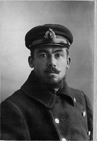
Georgy Nikolaevich Rybin, was a Russian hуdrographer; explorer of the Arctic seas and the Baltic Sea.
Navy Captain Joseph Abulu was the first Military Administrator of Anambra State in Nigeria from 27 August 1991 to 1 January 1992 after the Enugu State had been split from the old Anambra during the military regime of General Ibrahim Babangida.
Rear Admiral Y. N. Jayarathna, RWP, RSP, USP is a retired Sri Lankan naval officer and hydrographer. He served as the Chief of Staff of the Sri Lanka Navy and Joint chief Hydrographer to the Government of Sri Lanka, former Commandant of the Naval and Maritime Academy and Commanding Officer, 4th Fast Attack Flotilla.
The Indian Naval Hydrographic Department (INHD), headed by the Chief Hydrographer to the Government of India, is an Indian government agency responsible for hydrographic surveys and nautical charting in India. Its headquarters National Hydrographic Office is located in Dehradun, Uttarakhand beside the Principal Controller of Defense Accounts Office. Presently, the department is equipped with Seven indigenously built survey ships including a catamaran hull survey vessel (CHSV). The National Institute of Hydrography is the training institute to impart knowledge regarding hydrography and to train its personnel. Two more ships are currently being constructed and is expected to be commissioned into service by 2025-26.

The BAP Carrasco is an oceanographic research vessel of the Peruvian Navy built in 2016 by Freire Shipyard in Vigo (Spain). Its purpose is to perform oceanographic research cruises both in Peruvian waters and in Antarctica, in order to fulfill Peru's commitment under the Antarctic Treaty. The ship is endowed with technical capabilities for activities of hydrography, oceanography, marine meteorology, and marine geology. It also has polar capability and it is classified with PC7 notation. Since 2017 the ship has become the main platform for Peruvian annual expeditions to Antarctica.

The Russian Hydrographic Service, full current official name Department of Navigation and Oceanography of the Ministry of Defence of the Russian Federation, is Russia's hydrographic office, with responsibility to facilitate navigation, performing hydrographic surveys and publishing nautical charts.

USNS Chauvenet (T-AGS-29) was a multi-function survey ship laid down on 24 May 1967, at Upper Clyde Shipbuilding Corp., Glasgow, Scotland. The ship was the second survey ship, Chauvenet (AGS-11) being the first, named for William Chauvenet (1820-1870). He was instrumental in the founding of the United States Naval Academy at Annapolis, MD. The mathematics department of the US Naval Academy in Annapolis was founded by Chauvenet and is housed in Chauvenet Hall. Chauvenet was launched on 13 May 1968, delivered to the US Navy, 13 November 1970 and placed in service with the Military Sealift Command (MSC) as USNS Chauvenet (T-AGS-29). The ship conducted coastal hydrographic and topographic surveys under the technical direction of the Oceanographer of the Navy through the U.S. Naval Oceanographic Office (NAVOCEANO). The ship was assigned to the Pacific for surveys, sister ship Harkness (T-AGS-32) was assigned Atlantic duties, doing so until inactivated in November 1992.

Vice-Admiral Sir John Augustine Edgell, KBE, CB, FRS was an officer in the Royal Navy and Hydrographer of the Navy from 1932 to 1945. He was noted for his support for innovations such as echo sounding and radio navigation, for the surveying and chart production operations of his department during World War II, and for his advocacy of the science of oceanography
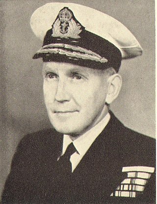
Sir Archibald Day was an officer in the Royal Navy and Hydrographer of the Navy from 1950-1955. He played an important part in planning the evacuation from Dunkirk in 1940, and wrote a history of the Hydrographic Service.
The Hydrographic Institute of the Republic of Croatia is a government agency responsible for providing hydrographic and marine geospatial data for the Republic of Croatia. The institute is located in Split, and covers scientific research and development, services related to the safety of navigation, the hydrographic-geodetic survey of the Adriatic sea, marine geodesy, design and publication of nautical charts and books, oceanographic research, and submarine geology research. The Croatian Hydrographic Institute is responsible for the development of navigational safety service in the Adriatic, within the worldwide navigational safety system, and in cooperation with the Ministry of the Sea, Transport and Infrastructure, port authorities, the Croatian Navy, lighthouse authorities, and hydrographic offices of all maritime countries, following internationally agreed standards.

