Papuri is an island of the Gambier Islands of French Polynesia. [1]

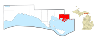
Drummond Township, which comprises Drummond Island, is a civil township of Chippewa County in the U.S. state of Michigan. The population was 973 at the 2020 census.
Clark Township is a civil township of Mackinac County in the U.S. state of Michigan. As of the 2010 census, the township population was 2,256.

Douglas Island is a tidal island in the U.S. state of Alaska. It is part of the city and borough of Juneau, just west of downtown Juneau and east of Admiralty Island. It is separated from mainland Juneau by the Gastineau Channel, and contains the communities of Douglas and West Juneau.

The Northwestern Hawaiian Islands or Leeward Hawaiian Islands are a series of islands and atolls in the Hawaiian island chain located northwest of the islands of Kauai and Niihau. Politically, they are all part of Honolulu County in the U.S. state of Hawaii, except Midway Atoll, which is a territory distinct from the State of Hawaii, and grouped as one of the United States Minor Outlying Islands. The United States Census Bureau defines this area, except Midway, as Census Tract 114.98 of Honolulu County. Its total land area is 3.1075 square miles (8.048 km2). All the islands except Nihoa are north of the Tropic of Cancer, making them the only islands in Hawaii that lie outside the tropics.

Devon Island is an island in Canada and the largest uninhabited island in the world. It is located in Baffin Bay, Qikiqtaaluk Region, Nunavut, Canada. It is one of the largest members of the Arctic Archipelago, the second-largest of the Queen Elizabeth Islands, Canada's sixth-largest island, and the 27th-largest island in the world. It has an area of 55,247 km2 (21,331 sq mi). The bedrock is Precambrian gneiss and Paleozoic siltstones and shales. The highest point is the Devon Ice Cap at 1,920 m (6,300 ft) which is part of the Arctic Cordillera. Devon Island contains several small mountain ranges, such as the Treuter Mountains, Haddington Range and the Cunningham Mountains. The notable similarity of its surface to that of Mars has attracted interest from scientists.
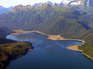
Admiralty Island is an island in the Alexander Archipelago in Southeast Alaska, at 57°44′N134°20′W. It is 145 km (90 mi) long and 56 km (35 mi) wide with an area of 4,264.1 km2 (1,646.4 sq mi), making it the seventh-largest island in the United States and the 132nd largest island in the world. It is one of the ABC islands in Alaska. The island is nearly cut in two by the Seymour Canal; to its east is the long, narrow Glass Peninsula. Most of Admiralty Island—955,747 acres (3,868 km2)—is protected as the Admiralty Island National Monument administered by the Tongass National Forest. The Kootznoowoo Wilderness encompasses vast stands of old-growth temperate rainforest. These forests provide some of the best habitat available to species such as brown bears, bald eagles, and Sitka black-tailed deer.

Drumbeg Provincial Park is a provincial park on Gabriola Island in British Columbia, Canada.
Arthur Adams was an English physician and naturalist.

Coronation Island is located in Alaska off the northwest coast of Prince of Wales Island, south of Kuiu Island, and north of Noyes Island. High prevailing winds and waves from the open ocean to the west, combined with a steep, rocky coast, result in virtually unaccessible shore due to heavy surf along the windward coastline of the island. The few protected coves and beaches along the leeward shore are guarded by rocky shoals. Thus, the island is difficult to access by any route, and is generally limited to small boat or floatplane during brief lulls in the weather. There are no developed facilities and no groomed trails on the island. Wilderness camping is unrestricted and fishing and hunting are allowed. The nearest full-service community is Craig, Alaska. The island is also home to the Coronation Island Wilderness, which encompasses 19,232 acres (78 km2) and includes the adjacent Spanish Islands. There are several sea caves on the island, and some of these contain fossils.

Electronic Attack Squadron 134 (VAQ-134) is an electronic warfare squadron of the United States Navy. It is nicknamed "Garudas" and is based at Naval Air Station Whidbey Island, Washington. The squadron is currently equipped with the Boeing EA-18G Growler.

Tenakee Seaplane Base is a state-owned public-use seaplane base located in Tenakee Springs, a city on Chichagof Island in the Hoonah-Angoon Census Area of the U.S. state of Alaska. Scheduled airline service is subsidized by the Essential Air Service program.
The temperate rainforests of Admiralty Island's Kootznoowoo Wilderness are unique among the 5,700,000 acres (2,300,000 ha) of federally protected Wilderness in Southeast Alaska.

Apéndice Island, also known as Isla Telegrafista Rivera or Sterneck Island, is an island in Hughes Bay lying north of Renzo Point on Relyovo Peninsula and west of Sucia Point on Sladun Peninsula, Graham Land in Antarctica. The name appears on an Argentine government chart of 1957. It forms part of the Cierva Point and offshore islands Important Bird Area and ASPA 134.
Midas Island is an island lying north-west of Apéndice Island in Hughes Bay, off the west coast of Graham Land, Antarctica. It was first seen by the Belgian Antarctic Expedition under Gerlache in 1898 and described as an island with two summits "like the ears of an ass". The name, given by the UK Antarctic Place-Names Committee in 1960, derives from this description; Midas, King of Phrygia, was represented in Greek satyric drama with the ears of an ass.
The Cierva Point and offshore islands Important Bird Area is a 6540 ha tract of land and sea on the Danco Coast of the Antarctic Peninsula.
Makapu is an island of the Gambier Islands of French Polynesia.
Manui is an island of the Gambier Islands of French Polynesia.

Kouaku is an island of the Gambier Islands of French Polynesia.
Puaumu is an island of the Gambier Islands of French Polynesia.
| | This French Polynesia-related geography article is a stub. You can help Wikipedia by expanding it. |
Coordinates: 23°0′24.43″S134°57′49.75″W / 23.0067861°S 134.9638194°W