
Flint, occasionally flintstone, is a sedimentary cryptocrystalline form of the mineral quartz, categorized as the variety of chert that occurs in chalk or marly limestone. Flint was widely used historically to make stone tools and start fires.

Chalk is a soft, white, porous, sedimentary carbonate rock. It is a form of limestone composed of the mineral calcite and originally formed deep under the sea by the compression of microscopic plankton that had settled to the sea floor. Chalk is common throughout Western Europe, where deposits underlie parts of France, and steep cliffs are often seen where they meet the sea in places such as the Dover cliffs on the Kent coast of the English Channel.

Chert is a hard, fine-grained sedimentary rock composed of microcrystalline or cryptocrystalline quartz, the mineral form of silicon dioxide (SiO2). Chert is characteristically of biological origin, but may also occur inorganically as a chemical precipitate or a diagenetic replacement, as in petrified wood.
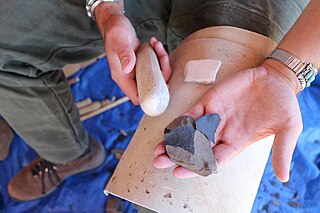
Knapping is the shaping of flint, chert, obsidian, or other conchoidal fracturing stone through the process of lithic reduction to manufacture stone tools, strikers for flintlock firearms, or to produce flat-faced stones for building or facing walls, and flushwork decoration. The original Germanic term knopp meant to strike, shape, or work, so it could theoretically have referred equally well to making statues or dice. Modern usage is more specific, referring almost exclusively to the hand-tool pressure-flaking process pictured. It is distinguished from the more general verb "chip" and is different from "carve", and "cleave".

Flint glass is optical glass that has relatively high refractive index and low Abbe number. Flint glasses are arbitrarily defined as having an Abbe number of 50 to 55 or less. The currently known flint glasses have refractive indices ranging between 1.45 and 2.00. A concave lens of flint glass is commonly combined with a convex lens of crown glass to produce an achromatic doublet lens because of their compensating optical properties, which reduces chromatic aberration.

The Chiltern Hills are a chalk escarpment in England northwest of London, covering 660 square miles (1,700 km2) across Oxfordshire, Buckinghamshire, Hertfordshire, and Bedfordshire, stretching 45 miles (72 km) from Goring-on-Thames in the southwest to Hitchin in the northeast. The hills are 12 miles (19 km) at their widest.

The North Downs are a ridge of chalk hills in south east England that stretch from Farnham in Surrey to the White Cliffs of Dover in Kent. Much of the North Downs comprises two Areas of Outstanding Natural Beauty (AONBs): the Surrey Hills and the Kent Downs. The North Downs Way National Trail runs along the North Downs from Farnham to Dover.

Grime's Graves is a large Neolithic flint mining complex in Norfolk, England. It lies 8 km (5.0 mi) north east from Brandon, Suffolk in the East of England. It was worked between c. 2600 and c. 2300 BC, although production may have continued through the Bronze and Iron Ages and later, owing to the low cost of flint compared with metals. Flint was much in demand for making polished stone axes in the Neolithic period. Much later, when flint had been replaced by metal tools, flint nodules were in demand for other uses, such as for building and as strikers for muskets.

The Chalk Group is the lithostratigraphic unit which contains the Upper Cretaceous limestone succession in southern and eastern England. The same or similar rock sequences occur across the wider northwest European chalk 'province'. It is characterised by thick deposits of chalk, a soft porous white limestone, deposited in a marine environment.

Cissbury Ring is an 84.2-hectare (208-acre) biological Site of Special Scientific Interest north of Worthing in West Sussex. It is owned by the National Trust and is designated a Scheduled monument for its Neolithic flint mine and Iron Age hillfort.
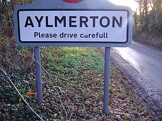
Aylmerton is a village in the county of Norfolk, England. It is in the area of North Norfolk and lies 2.2 miles (3.5 km) south of the North Sea, 3.2 miles (5.1 km) south-west of Cromer and 7.5 miles (12.1 km) east of Holt. The parish is bordered by the parishes of Beeston Regis and Runton to the north, West Beckham to the west, Felbrigg to the east and Gresham and Sustead to the south. The centre of the village is ¾ miles south of the A148 King’s Lynn to Cromer road with Sandy Lane and Beechwood Avenue north of it. The nearest railway stations are West Runton at the bottom of Sandy Lane, Cromer at 2.9 miles (4.7 km) and Roughton Road at 4.1 miles (6.6 km). The civil parish has an area of 6.86 square kilometres and in the 2001 census the population was 435 in 178 households, increasing to 458 at the 2011 Census. For the purposes of local government, the parish is in North Norfolk, whose headquarters are in Cromer.

Beeston Regis is a village and civil parish in the North Norfolk district of Norfolk, England. It is about a mile (2 km) east of Sheringham, Norfolk and near the coast. The village is 2 miles (3 km) west of Cromer and 16 miles (26 km) north of the city of Norwich. According to the 2011 census, it had a population of 1,062. There is a frequent bus service on the coast road A149 and a rail service from the nearby stations of Sheringham to the west and West Runton to the east, where the Bittern Line runs a frequent service between Norwich, Cromer and Sheringham. The nearest airport is Norwich International Airport.

West Runton is a village in North Norfolk, England, on the North Sea coast.
The prehistory of the County of Norfolk, England is broken into specific time periods, these being Palaeolithic, Mesolithic and Neolithic.
A flint axe was a Flint tool used during prehistoric times to perform a variety of tasks. These were at first just a cut piece of flint stone used as a hand axe but later wooden handles were attached to these axe heads. The stone exhibits a glass-like fracture similar to obsidian, and can be knapped to form large blades. The offcuts were sharp enough to be used a small flint knives, while the larger parts of a knapped nodule could be polished to form an axe-head. They competed with other hard rocks such as greenstone, which were produced at Langdale in the British Lake District and got larger as working continued. They tend to be larger and heavier than the simple axes, and are sometimes known as axe-hammers.

In architecture, flushwork is decorative masonry work which combines on the same flat plane flint and ashlar stone. If the stone projects from a flat flint wall then the term is proudwork, as the stone stands "proud" rather than being "flush" with the wall.
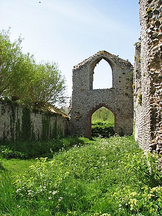
The Priory of St Mary in the Meadow, also known as Beeston Priory is a former Augustinian Priory, located in the village of Beeston Regis, Norfolk, United Kingdom.

The Neolithic flint mines of Spiennes are among the largest and earliest Neolithic flint mines which survive in north-western Europe, located close to the Walloon village of Spiennes, southeast of Mons, Belgium. The mines were active during the mid and late Neolithic between 4,300 and 2,200 BC. Declared to be "remarkable for the diversity of technological solutions used for extraction" the site and its surroundings were inducted into the UNESCO's list of World Heritage Sites in 2000.

The Norwich Crag Formation is a stratigraphic unit of the British Pleistocene Epoch. It is the second youngest unit of the Crag Group, a sequence of four geological formations spanning the Pliocene to Lower Pleistocene transition in East Anglia. It was deposited between approximately 2.4 and 1.8 million years ago, during the Gelasian Stage.

Rügen chalk is the common name for a very pure, very fine-grained, white, crumbly and highly porous chalk that forms the highest member of the German Upper Cretaceous, and is of Maastrichtian age. It is found exposed in cliffs on the coast of the Jasmund peninsula in the northeast of the island of Rügen in Mecklenburg-Vorpommern.
