Related Research Articles
Northridge is a neighborhood in the San Fernando Valley region of the City of Los Angeles. The community is home to California State University, Northridge, and the Northridge Fashion Center.

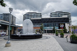
Reston is a census-designated place in Fairfax County, Virginia. Founded in 1964, Reston was influenced by the Garden City movement that emphasized planned, self-contained communities that intermingled green space, residential neighborhoods, and commercial development. The intent of Reston's founder, Robert E. Simon, was to build a town that would revolutionize post–World War II concepts of land use and residential/corporate development in suburban America. In 2018, Reston was ranked as the Best Place to Live in Virginia by Money magazine for its expanses of parks, lakes, golf courses, and bridle paths as well as the numerous shopping and dining opportunities in Reston Town Center.

Kingwood is a 14,000 acre (57 km²) master-planned community located in northeast Houston, Texas, United States. The majority of the community is located in Harris County with a small portion in Montgomery County. Known as the "Livable Forest," it is the largest master-planned community in Harris County and second-largest within the 10-county Houston-The Woodlands-Sugar Land metropolitan area. It was classified as a "census-designated place" during the 1990 census, when the population recorded was 37,397. It is on the east fork of the San Jacinto River.
Don Mills is a mixed-use neighbourhood in the North York district of Toronto, Ontario, Canada. It was developed to be a self-supporting "new town" and was at the time located outside Toronto proper. In 1998, North York, including the Don Mills community, was amalgamated into Toronto proper. Consisting of residential, commercial and industrial sub-districts, it was planned and developed by private enterprise.
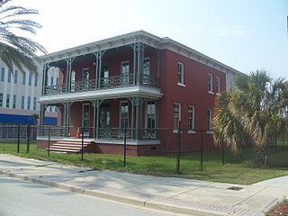
The Brewster Hospital building is a historic U.S. hospital in the LaVilla neighborhood of Jacksonville, Florida. It is located at 915 West Monroe Street. On May 13, 1976, it was added to the U.S. National Register of Historic Places.

Century City is a 176-acre neighborhood and business district in Los Angeles, California. Located on the Westside to the south of Santa Monica Boulevard around 10 miles (16 km) west of Downtown Los Angeles, Century City is one of the most prominent employment centers in the Los Angeles metropolitan area, and its skyscrapers form a distinctive skyline on the Westside.
Land use planning is the process of regulating the use of land by a central authority. Usually, this is done to promote more desirable social and environmental outcomes as well as a more efficient use of resources. More specifically, the goals of modern land use planning often include environmental conservation, restraint of urban sprawl, minimization of transport costs, prevention of land use conflicts, and a reduction in exposure to pollutants. In the pursuit of these goals, planners assume that regulating the use of land will change the patterns of human behavior, and that these changes are beneficial. The first assumption, that regulating land use changes the patterns of human behavior is widely accepted. However, the second assumption - that these changes are beneficial - is contested, and depends on the location and regulations being discussed.

The Hollywood Sign is an American landmark and cultural icon overlooking Hollywood, Los Angeles, California. It is situated on Mount Lee, in the Beachwood Canyon area of the Santa Monica Mountains. Spelling out the word Hollywood in 45 ft (13.7 m)-tall white capital letters and 350 feet long, it was originally created in 1923 as a temporary advertisement for a local real estate development, but due to increasing recognition the sign was left up, and replaced in 1978 with a more durable all-steel structure.
Mid-Wilshire is a neighborhood in the central region of Los Angeles, California. It is known for the Los Angeles County Museum of Art, the Petersen Automotive Museum, and the Miracle Mile shopping district.
Central Los Angeles is the historic urban region of the City of Los Angeles, California.

The Kashia Band of Pomo Indians of the Stewarts Point Rancheria is a federally recognized tribe of Pomo people in Sonoma County, California. They are also known as the Kashaya Pomo.
Sterling Forest State Park is a 21,938-acre (88.78 km2) state park located in the Ramapo Mountains in Orange County, New York. Established in 1998, it is among the larger additions to the New York state park system in the last 50 years.
The Trust for Public Land is a U.S. nonprofit organization with a mission to "create parks and protect land for people, ensuring healthy, livable communities for generations to come". Since its founding in 1972, The Trust for Public Land has completed 5,000 park-creation and land conservation projects across the United States, protected over 3 million acres, and helped pass more than 500 ballot measures—creating $70 billion in voter-approved public funding for parks and open spaces. The Trust for Public Land also researches and publishes authoritative data about parks, open space, conservation finance, and urban climate change adaptation. Headquartered in San Francisco, the organization is among the largest U.S. conservation nonprofits, with approximately 30 field offices across the U.S., including a federal affairs function in Washington, D.C.
Baldwin Hills/Crenshaw is a neighborhood in the south region of the city of Los Angeles. It is divided between the upscale, principally home-owning Baldwin Hills residential district to the south and a more concentrated apartment area to the north, just south of Jefferson Boulevard. A commercial corridor along Crenshaw Boulevard includes Baldwin Hills Crenshaw Plaza, Marlton Square and Crenshaw Boulevard.
iNaturalist is a social network of naturalists, citizen scientists, and biologists built on the concept of mapping and sharing observations of biodiversity across the globe. iNaturalist may be accessed via its website or from its mobile applications. As of February 2021, iNaturalist users had contributed approximately 66 million observations of plants, animals, fungi, and other organisms worldwide, and around 130,000 users were active in the previous 30 days.
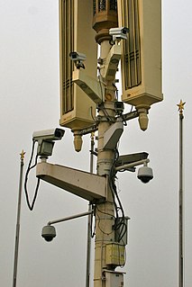
Mass surveillance in China is the network of monitoring systems used by the Chinese government to monitor Chinese citizens. It is primarily conducted through the government, although non-publicized corporate surveillance in connection with the Chinese government has been speculated to occur. China monitors its citizens through Internet, camera as well as through other digital technologies. It has become increasingly widespread under General Secretary of the Chinese Communist Party (CCP) Xi Jinping's administration.

Urban planning, also known as regional planning, town planning, city planning, or rural planning, is a technical and political process that is focused on the development and design of land use and the built environment, including air, water, and the infrastructure passing into and out of urban areas, such as transportation, communications, and distribution networks and their accessibility. Traditionally, urban planning followed a top-down approach in master planning the physical layout of human settlements. The primary concern was the public welfare, which included considerations of efficiency, sanitation, protection and use of the environment, as well as effects of the master plans on the social and economic activities. Over time, urban planning has adopted a focus on the social and environmental bottom-lines that focus on planning as a tool to improve the health and well-being of people while maintaining sustainability standards. Sustainable development was added as one of the main goals of all planning endeavors in the late 20th century when the detrimental economic and the environmental impacts of the previous models of planning had become apparent. Similarly, in the early 21st century, Jane Jacob's writings on legal and political perspectives to emphasize the interests of residents, businesses and communities effectively influenced urban planners to take into broader consideration of resident experiences and needs while planning.
The Big Sur Land Trust is a private 501(c)(3) non-profit located in Monterey, California, that has played an instrumental role in preserving land in California's Big Sur and Central Coast regions. The trust was the first to conceive of and use the "conservation buyer" method in 1989 by partnering with government and developers to offer tax benefits as an inducement to sell land at below-market rates. As of 2016, it has protected around 40,000 acres (16,187 ha) through acquisition and resale to government agencies. It has added conservation easements to another 17,000 acres (6,880 ha) and has retained ownership of a number of parcels totaling about 4,500 acres (1,821 ha).
The 10-Minute Walk, also known as the 10-Minute Walk to a Park, refers to a grassroots parks-advocacy movement to ensure that everyone in the United States lives within a ten-minute walk to a high-quality park or green space. The effort was adopted as a resolution at the 85th annual United States Conference of Mayors convention in 2017 as a goal for cities to increase parks and green space as a civic responsibility. The concept has been supported by several community-based nonprofit organizations including The Trust for Public Land, the National Recreation and Park Association, the Urban Land Institute, and Fields in Trust in the UK. A ten-minute walk is commonly considered to be half a mile, which is the distance the National Park Service and the Centers for Disease Control and Prevention uses when they link park access and public health.
Community gardens in New York City are urban green spaces created and cared for by city residents who are stewards of underutilized land. There are over 550 community gardens on city property, over 745 school gardens, over 100 gardens in land trusts, and over 700 gardens at public housing developments throughout New York City.
References
- ↑ "The Trust for Public Land Makes Park Information Database and Platform Available to Millions". The Trust for Public Land. Retrieved 2018-08-16.
- ↑ "New ParkServe Database Maps Parks in U.S. Cities". Children & Nature Network. 2018-05-04. Retrieved 2018-08-16.
- 1 2 "Research Tools: ParkServe Database and Interactive Mapping Website Unveiled by The Trust for Public Land". LJ infoDOCKET. Retrieved 2018-08-16.