Richmond Green is a recreation area near the centre of Richmond, a town of about 20,000 inhabitants situated in south-west London. Owned by the Crown Estate, it is leased to the London Borough of Richmond upon Thames. The Green, which has been described as "one of the most beautiful urban greens surviving anywhere in England", is roughly square in shape and its open grassland, framed with broadleaf trees, extends to roughly twelve acres. On the north-east side there is also a smaller open space called Little Green. Richmond Green and Little Green are overlooked by a mixture of period townhouses, historic buildings and municipal and commercial establishments including the Richmond Lending Library and Richmond Theatre.

Melbourne Hall is a Georgian style country house in Melbourne, Derbyshire, previously owned by William Lamb, 2nd Viscount Melbourne, British Prime Minister from 1835 to 1841. The house is now the seat of Lord and Lady Ralph Kerr and is open to the public. The house is a Grade II* listed building; more than twenty features in the grounds are Grade I listed.

Dodington Park is a country house and estate in Dodington, South Gloucestershire, England. The house was built by James Wyatt for Christopher Bethell Codrington. The family had made their fortune from sugar plantations in the Caribbean and were significant owners of slaves. It remained in the Codrington family until 1980; it is now owned by the British businessman James Dyson.

Leinster Gardens is a street in Bayswater, London. It is lined with tall, ornate, mid-Victorian terraced houses, many of which are listed buildings.

Bryanston Square is an 800-by-200-foot garden square in Marylebone, London. Terraced buildings surround it — often merged, converted or sub-divided, some of which remain residential. The southern end has the William Pitt Byrne memorial fountain. Next to both ends are cycle parking spaces.

Cavendish Square is a public garden square in Marylebone in the West End of London. It has a double-helix underground commercial car park. Its northern road forms ends of four streets: of Wigmore Street that runs to Portman Square in the much larger Portman Estate to the west; of Harley Street which runs an alike distance; of Chandos Street which runs for one block and; of Cavendish Place which runs the same. The south side itself is modern: the rear façade and accesses to a flagship department store and office block. On the ground floors facing are Comptoir Libanais, Royal Bank of Scotland and Pret a Manger premises.

Cadogan Place is a street in Belgravia, London. It is named after Earl Cadogan and runs parallel to the lower half of Sloane Street. It gives its name to the extensive Cadogan Place Gardens, private communal gardens maintained for Cadogan residents. It is owned by Cadogan Estates.

There are 24 Grade I listed buildings in the city of Brighton and Hove, England. The city, on the English Channel coast approximately 52 miles (84 km) south of London, was formed as a unitary authority in 1997 by the merger of the neighbouring towns of Brighton and Hove. Queen Elizabeth II granted city status in 2000.

Amon Henry Wilds was an English architect. He was part of a team of three architects and builders who—working together or independently at different times—were almost solely responsible for a surge in residential construction and development in early 19th-century Brighton, which until then had been a small but increasingly fashionable seaside resort on the East Sussex coast. In the 1820s, when Wilds, his father Amon Wilds and Charles Busby were at their most active, nearly 4,000 new houses were built, along with many hotels, churches and venues for socialising; most of these still survive, giving Brighton a distinctive Regency-era character, and many are listed buildings.
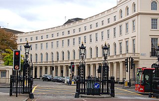
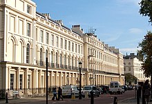
Park Crescent is at the north end of Portland Place and south of Marylebone Road in London. The crescent consists of elegant stuccoed terraced houses by the architect John Nash, which form a semicircle. The crescent is part of Nash's and wider town-planning visions of Roman-inspired imperial West End approaches to Regent's Park. It was originally conceived as a circus (circle) to be named Regent's Circus but instead Park Square was built to the north. The only buildings on the Regent's Park side of the square are small garden buildings, enabling higher floors of the Park Crescent buildings to have a longer, green northern view.

As of February 2001, there were 1,124 listed buildings with Grade II status in the English city of Brighton and Hove. The total at 2009 was similar. The city, on the English Channel coast approximately 52 miles (84 km) south of London, was formed as a unitary authority in 1997 by the merger of the neighbouring towns of Brighton and Hove. Queen Elizabeth II granted city status in 2000.

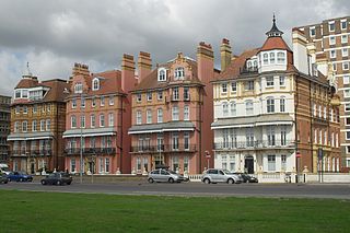
Park Crescent is a mid-19th-century residential development in the Round Hill area of Brighton, part of the English city of Brighton and Hove. The horseshoe-shaped, three-part terrace of 48 houses was designed and built by one of Brighton's most important architects, Amon Henry Wilds; by the time work started in 1849 he had 35 years' experience in the town. Wilds used the Italianate style rather than his more common Regency motifs. Three houses were replaced after the Second World War because of bomb damage, and another was the scene of one of Brighton's notorious "trunk murders" of the 1930s. The three parts of the terrace, which encircle a private garden formerly a pleasure ground and cricket pitch, have been listed at Grade II* by English Heritage for their architectural and historical importance.

As of February 2001, there were 1,124 listed buildings with Grade II status in the English city of Brighton and Hove. The total at 2009 was similar. The city, on the English Channel coast approximately 52 miles (84 km) south of London, was formed as a unitary authority in 1997 by the merger of the neighbouring towns of Brighton and Hove. Queen Elizabeth II granted city status in 2000.

The Kingston House estate and Ennismore Gardens in Knightsbridge is a green, dual-character area within the western limits of the City of Westminster in London. The first-named is immediately south of Hyde Park, London taking up the park's semi-panorama row of 8 to 13 Princes Gate (demolished) and otherwise, as to more of its wings, set around the east of Princes Gate Garden including a terrace of houses №s 1 to 7 Bolney Gate. The second-named is a garden square of 59 tall creamy-white terraced houses and the approach road to Prince of Wales Gate, Hyde Park as well as the identical-size public, square green of the church that is since 1956 the Russian Orthodox Cathedral of the Dormition of the Mother of God and All Saints facing which green are its anomalous outlier row for a London garden square, №s 61 to 66. The relatively small, broad-fronted house set against the Consulate-used pairing at №s 61 to 62 is № 60 and as with the other 65 numbers of Ennismore Gardens is a listed building.

York Terrace overlooks the south side of Regent's Park in Marylebone, City of Westminster, London, England. York Terrace West is a Grade I listed building. York Terrace East contains Grade II listed buildings. 1–18 York Terrace East is listed at Grade I.
As of February 2001, there were 1,124 listed buildings with Grade II status in the English city of Brighton and Hove. The total at 2009 was similar. The city, on the English Channel coast approximately 52 miles (84 km) south of London, was formed as a unitary authority in 1997 by the merger of the neighbouring towns of Brighton and Hove. Queen Elizabeth II granted city status in 2000.

As of February 2001, there were 1,124 listed buildings with Grade II status in the English city of Brighton and Hove. The total at 2009 was similar. The city, on the English Channel coast approximately 52 miles (84 km) south of London, was formed as a unitary authority in 1997 by the merger of the neighbouring towns of Brighton and Hove. Queen Elizabeth II granted city status in 2000.

As of February 2001, there were 1,124 listed buildings with Grade II status in the English city of Brighton and Hove. The total at 2009 was similar. The city, on the English Channel coast approximately 52 miles (84 km) south of London, was formed as a unitary authority in 1997 by the merger of the neighbouring towns of Brighton and Hove. Queen Elizabeth II granted city status in 2000.

As of February 2001, there were 1,124 listed buildings with Grade II status in the English city of Brighton and Hove. The total at 2009 was similar. The city, on the English Channel coast approximately 52 miles (84 km) south of London, was formed as a unitary authority in 1997 by the merger of the neighbouring towns of Brighton and Hove. Queen Elizabeth II granted city status in 2000.
As of February 2001, there were 1,124 listed buildings with Grade II status in the English city of Brighton and Hove. The total at 2009 was similar. The city, on the English Channel coast approximately 52 miles (84 km) south of London, was formed as a unitary authority in 1997 by the merger of the neighbouring towns of Brighton and Hove. Queen Elizabeth II granted city status in 2000.