Parr's Ridge

Last updated

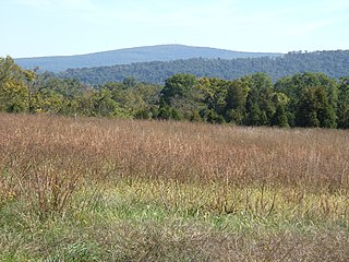
Parr's Ridge is a ridge which forms the summit of the Piedmont Plateau region in the U.S. state of Maryland.

Ridge A geological feature consisting of a chain of mountains or hills that form a continuous elevated crest for some distance

A ridge or a mountain ridge is a geological feature consisting of a chain of mountains or hills that form a continuous elevated crest for some distance. The sides of the ridge slope away from narrow top on either side.The line along the crest formed by the highest points, with the terrain dropping down on either side, is called the ridgeline. Ridges are usually termed hills or mountains as well, depending on size.

Piedmont (United States) plateau region located in the eastern United States

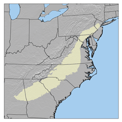
The Piedmont is a plateau region located in the Eastern United States. It sits between the Atlantic coastal plain and the main Appalachian Mountains, stretching from New Jersey in the north to central Alabama in the south. The Piedmont Province is a physiographic province of the larger Appalachian division which consists of the Gettysburg-Newark Lowlands, the Piedmont Upland and the Piedmont Lowlands sections.

Maryland State of the United States of America

Maryland is a state in the Mid-Atlantic region of the United States, bordering Virginia, West Virginia, and the District of Columbia to its south and west; Pennsylvania to its north; and Delaware to its east. The state's largest city is Baltimore, and its capital is Annapolis. Among its occasional nicknames are Old Line State, the Free State, and the Chesapeake Bay State. It is named after the English queen Henrietta Maria, known in England as Queen Mary.

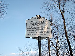
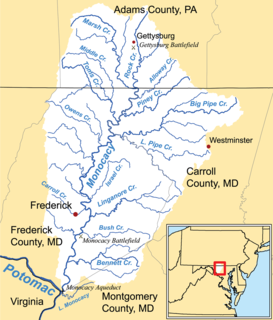
The ridge, a gentle summit by contrast to Maryland's Appalachian ridges to the west, extends from southwest to northeast through Montgomery, Howard and Carroll counties. The highest point in Maryland east of the Appalachian Mountains, Dug Hill in northern Carroll County, at an elevation of just over 1100 feet (335 m), is a mile or two to the west of the ridge. The Patuxent and Patapsco rivers both have headwaters on the ridge. The South branch of the Patapsco's headwaters point is dubbed Parr's Spring, and is the meeting point of four of Maryland's counties: Howard, Carroll, Montgomery, and Frederick. The Spring is submerged beneath a pond on the grounds of the eponymous "Four County Farm."

Appalachian Mountains mountain range in the eastern United States and Canada

The Appalachian Mountains, often called the Appalachians, are a system of mountains in eastern North America. The Appalachians first formed roughly 480 million years ago during the Ordovician Period. They once reached elevations similar to those of the Alps and the Rocky Mountains before experiencing natural erosion. The Appalachian chain is a barrier to east–west travel, as it forms a series of alternating ridgelines and valleys oriented in opposition to most highways and railroads running east–west.

Montgomery County, Maryland County in Maryland

Montgomery County is the most populous county in the U.S. state of Maryland, located adjacent to Washington, D.C. As of the 2010 census, the county's population was 971,777, increasing by 8.3% to an estimated 1,052,567 in 2018. The county seat and largest municipality is Rockville, although the census-designated place of Germantown is the most populous place. Montgomery County is included in the Washington–Arlington–Alexandria, DC–VA–MD–WV Metropolitan Statistical Area, which in turn forms part of the Baltimore–Washington Combined Statistical Area. Most of the county's residents live in unincorporated locales, of which the most built up are Silver Spring and Bethesda, although the incorporated cities of Rockville and Gaithersburg are also large population centers, as are many smaller but significant places.

Howard County, Maryland County in the United States

Howard County is a county in the central part of the U.S. state of Maryland. As of the 2010 census, the population was 287,085. Its county seat is Ellicott City.

The area was surveyed by John Parr in 1744, patenting the land as "Parr's Range". David McMurtrie Gregg marched his troops through the area during the civil war on the way to Gettysburg. [1]

David McMurtrie Gregg Union Army general

David McMurtrie Gregg was a farmer, diplomat, and a Union cavalry general in the American Civil War.

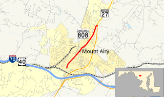
Maryland State Route 27 follows the course of Parr's Ridge.

Communities along Parr's Ridge include, from south to north, Damascus, Mount Airy (where Interstate 70 crosses the ridge), Westminster, Cranberry, Manchester, and Lineboro.

Damascus, Maryland Census-designated place in Maryland

Damascus is a census-designated place and an unincorporated area in Montgomery County, Maryland, United States. In the early 20th century, there existed an incorporated municipality lasting a quarter century.

Mount Airy, Maryland Town in Maryland

Mount Airy is a town in Carroll and Frederick counties in the U.S. state of Maryland. It is part of both the Washington Metropolitan Area and Baltimore Metropolitan Area. As of the 2010 census the population was 9,288.

Interstate 70 east-west Interstate across central US

Interstate 70 (I-70) is a major east–west Interstate Highway in the United States that runs from I-15 near Cove Fort, Utah, to I-695 near Baltimore, Maryland. I-70 approximately traces the path of U.S. Route 40 east of the Rocky Mountains. West of the Rockies, the route of I-70 was derived from multiple sources. The Interstate runs through or near many major cities, including Denver, Kansas City, St. Louis, Indianapolis, Columbus, Pittsburgh, and Baltimore.

Related Research Articles

Washington Township, Franklin County, Pennsylvania Township in Pennsylvania, United States

Washington Township is a township in Franklin County, Pennsylvania, United States. The population was 14,009 at the 2010 census, up from 11,559 at the 2000 census.

Eastern Continental Divide Hydrological divide in eastern North America

The Eastern Continental Divide or Eastern Divide or Appalachian Divide is a hydrographic divide in eastern North America that separates the easterly Atlantic Seaboard watershed from the westerly Gulf of Mexico watershed. The divide nearly spans the United States from south of Lake Ontario through the Florida peninsula, and consists of raised terrain including the Appalachian Mountains to the north, the southern Piedmont Plateau and lowland ridges in the Atlantic Coastal Plain to the south. Water including rainfall and snowfall, lakes, streams and rivers on the eastern/southern side of the divide drains to the Atlantic Ocean; water on the western/northern side of the divide drains to the Gulf of Mexico. The ECD is one of six continental hydrographic divides of North America which define several drainage basins, each of which drains to a particular body of water.

Backbone Mountain ridge of the Allegheny Mountains of the central Appalachian Mountain Range, in the U.S. states of West Virginia and Maryland

Backbone Mountain is a ridge of the Allegheny Mountains of the central Appalachian Mountain Range. It is situated in the U.S. states of West Virginia and Maryland and forms a portion of the Eastern Continental Divide. In the state of Maryland, Backbone Mountain reaches an elevation of 3,360 feet or 1,024 metres, making it Maryland’s highest point.

Patapsco River river in Maryland, United States

The Patapsco River mainstem is a 39-mile-long (63 km) river in central Maryland which flows into the Chesapeake Bay. The river's tidal portion forms the harbor for the city of Baltimore. With its South Branch, the Patapsco forms the northern border of Howard County, Maryland. The name "Patapsco" is derived from the Algonquian pota-psk-ut, which translates to "backwater" or "tide covered with froth."

Woodbine, Maryland Unincorporated community in Maryland

Woodbine is an unincorporated rural community in Howard and Carroll counties, Maryland, United States. It is part of the Baltimore metropolitan area. It is located southeast of Frederick, west of Baltimore, north of Washington, D.C., and east of Mount Airy. The community was named for the woodbine plant, which grew in the community in fields and along riverbanks.

Powell Mountain is a mountain ridge of the Ridge-and-valley Appalachians of the Appalachian Mountains. It is a long and narrow ridge, running northeast to southwest, from about Norton, Virginia to near Tazewell, Tennessee. It separates the Clinch River basin and the Powell River basin of Powell Valley. It was named for an 18th-century explorer.

The Appalachian National Scenic Trail spans fourteen U.S. states during its roughly 2,200 miles (3,500 km)-long journey: Georgia, North Carolina, Tennessee, Virginia, West Virginia, Maryland, Pennsylvania, New Jersey, New York, Connecticut, Massachusetts, Vermont, New Hampshire, and Maine. It begins at Springer Mountain, Georgia, and follows the ridgeline of the Appalachian Mountains, crossing many of its highest peaks and running with only a few exceptions almost continuously through wilderness before ending at Mount Katahdin, Maine.

Wills Mountain mountain in United States of America

Wills Mountain is a quartzite-capped ridge in the Ridge and Valley physiographic province of the Appalachian Mountains in Pennsylvania and Maryland, United States, extending from near Bedford, Pennsylvania, to near Cumberland, Maryland. It is the northernmost of several mountain ridges included within the Wills Mountain Anticline.

Maryland Route 27 highway in Maryland

Maryland Route 27 is a state highway in the U.S. state of Maryland. Known for most of its length as Ridge Road, the highway runs 39.17 miles (63.04 km) from MD 355 in Germantown north to MD 30 in Manchester. MD 27 follows a ridge that separates several watersheds in northern Montgomery County and Carroll County. The highway connects Germantown and Manchester with Damascus in far northern Montgomery County; Westminster, the county seat of Carroll County; and Mount Airy, which lies at the junction of Carroll, Frederick, Howard, and Montgomery counties and where MD 27 intersects Interstate 70 (I-70) and U.S. Route 40.

Ilchester, Maryland Census-designated place in Maryland

Ilchester is an unincorporated community and census-designated place in Howard County, Maryland, United States. The population was 23,476 at the 2010 census. It was named after the village of Ilchester in the English county of Somerset.

Lambs Knoll mountain in United States of America

Lambs Knoll is a peak of South Mountain on the border of Washington County and Frederick County in the state of Maryland, United States. The 1,758 feet (536 m) peak is the second tallest on South Mountain in Maryland behind Quirauk Mountain.

Broad Run is a tributary stream of the Potomac River in Montgomery County, Maryland. The headwaters of the stream originate west of the town of Poolesville, and the creek flows southward for 8.9 miles (14.3 km) to the Potomac River. The Broad Run and its watershed are almost entirely within the Montgomery County Agricultural Reserve.

Double Pipe Creek tributary of the Monocacy River in Maryland

Double Pipe Creek, sometimes called Pipe Creek, is a major tributary of the Monocacy River in Carroll County and Frederick County in Maryland, located several miles north and west of Westminster. The creek is only 1.6 miles (2.6 km) long, but is formed by the confluence of two much longer streams, Big Pipe Creek and Little Pipe Creek.

Gwynns Falls is a 24.9-mile-long (40.1 km) stream located in Baltimore County and Baltimore City, Maryland. Its headwaters are located in Reisterstown in Baltimore County, and the stream flows southeast, entering the city of Baltimore and emptying into the Middle Branch of the Patapsco River. The Patapsco drains into the Chesapeake Bay. The watershed area of Gwynns Falls covers 66 square miles (170 km2), with 133 miles (214 km) of streams.

Maryland Route 808 highway in Maryland

Maryland Route 808 is a state highway in the U.S. state of Maryland. Officially MD 808A and known as Main Street, the state highway runs 2.34 miles (3.77 km) from Ridgeville Boulevard north to MD 27 within Mount Airy. MD 808 follows the Carroll–Frederick county line for a portion of its length near its southern terminus. The county line portion is considered to be in Carroll County for maintenance purposes. MD 808 is the old alignment of MD 27 through Mount Airy. A portion of Main Street was paved by 1910; the sections south and north of the town center were constructed in the early 1910s and late 1910s, respectively. MD 808 was assigned to Main Street after MD 27's bypass of Mount Airy was completed in the mid-1970s.

Pen Mar Park

Pen Mar Park is a scenic area in Pen Mar, Washington County, Maryland. It is located on High Rock Road adjacent to the Mason–Dixon line. In 1877, the site was opened as an amusement park and resort area by the Western Maryland Railway (WM). During the summer months the railroad offered frequent train service on its "Blue Mountain Express" from Baltimore to Pen Mar. The WM also ran trains from Hagerstown, Maryland to Pen Mar.

Hood's Mill is an unincorporated community located in Howard County and Carroll County in the state of Maryland in the United States of America.

References

  1. Howard's Roads to the Past. Howard County Sesquicentennial Celebration Committee, 2001. 2001. p. 20.

Coordinates: 39°24′N77°8′W / 39.400°N 77.133°W / 39.400; -77.133

Geographic coordinate system Coordinate system

A geographic coordinate system is a coordinate system that enables every location on Earth to be specified by a set of numbers, letters or symbols. The coordinates are often chosen such that one of the numbers represents a vertical position and two or three of the numbers represent a horizontal position; alternatively, a geographic position may be expressed in a combined three-dimensional Cartesian vector. A common choice of coordinates is latitude, longitude and elevation. To specify a location on a plane requires a map projection.