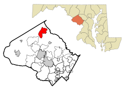
Damascus is a census-designated place and an unincorporated area in Montgomery County, Maryland, United States. In the early 20th century, there existed an incorporated municipality lasting a quarter century. It had a population of 17,224 as of the 2020 census.[3] Damascus is located at the intersection of two major roads in upper Montgomery County: Ridge Road (currently Rt. 27) and Damascus Road (currently Rt. 108).
The name was first used in an official document in 1816, when the United States Congress approved a postal route through the area, operated by Edward Hughes.
History
The area currently known as Damascus was granted by the new U.S. state of Maryland to Nathaniel Pigman in 1783. On February 14, 1819, War of 1812 veteran Edward Hughes bought a 40-acre (160,000m2) section of the grant and began subdividing lots for sale. James Madison, the fourth U.S. president, appointed Hughes postmaster of the developing community of Damascus in 1816.[4] Hughes received permission from Congress for a postal route through the town. Hughes called his town "The Pleasant Plains of Damascus" after Damascus, Syria. A newspaper in Frederick wrote of Hughes's growing town: "There is at this place an extensive opening for mechanics of all the different kinds, and it bids fair to improve very fast; ... There is at present two blacksmith shops, a saddler's shop and a store in the place -- a tailor, a wheel wright, and a shoemaker are much wanted, and would meet with great encouragement." This was the Damascus of 1816. The new township drew settlers from Anne Arundel County as well as from Montgomery County. On September 12, 1862, U.S. Army troops marched through the "village" of Damascus via what is now Route 27 on their way to the town of Sharpsburg, where they engaged Confederate troops commanded by General Robert E. Lee at the Battle of Antietam.[citation needed]
The town was incorporated from 1890 until 1914, when the townspeople requested the incorporation be withdrawn so that Old Quaker Road, used since Revolutionary times and before, could be paved into a state highway. The town remains a commercial center for rural communities like Clagettsville, Browningsville, Cedar Grove, Woodfield, King's Valley, Purdum, and Lewisdale, although it is more developed today.[4]
In spite of spiraling population growth and encroaching urban development, old-timers feel like Damascus retains its rural, small-town character. The Damascus Community Fair—a fully agricultural fair that has been in operation since 1940—attracts thousands of visitors annually in the first weekend of September. 4-H clubs and equestrian centers have retained their popularity in the area.[citation needed]
November 17, 2009 marked the grand opening of the Damascus Heritage Society Museum.[citation needed]
Damascus was Maryland's last dry town[5] until 2013, when townspeople passed a bill by referendum to allow the sale of beer and wine.[6]
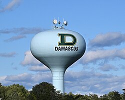
In 2017, Damascus parents and teachers raised funds to paint the town's water tower with the green-and-gold "D" logo displayed on the high school football helmets, as a way to honor the prestigious football team and turn the formerly plain-looking tower into an iconic town landmark. The tower can be seen from all around Damascus, and from the high school football field. Initially, the organizers planned to use the school's Swarmin' Hornet mascot, but Georgia Tech did not allow them to because of its similarity to their trademarked yellow-jacket logo.[7][8]
Geography
As an unincorporated area, Damascus' boundaries are not officially defined. Damascus is recognized by the United States Census Bureau as a census-designated place, and by the United States Geological Survey as a populated place located.[9] Damascus proper is a locally high spot at 847ft (258m) above sea level, while other portions of the area described as Damascus are as high as 866ft (264m) above sea level. However the highest elevation in the county is actually within what is considered Mt. Airy, MD, measuring 883ft (269m) above sea level at the Full Gospel Church. This peak just southwest of Mt. Airy is actually the highest elevation in the immediately adjacent Washington D.C. suburbs.
Damascus is west of the fall line between the Piedmont of Appalachia and the Atlantic coastal plain. Damascus is known for its rural landscape and family-owned farms. According to the United States Census Bureau, the place has a total area of 9.6 square miles (25km2), all land. 34
The town is located on Parr's Ridge, a low shale ridge that rises about 300 feet above the surrounding Piedmont. Open hilltops in the area afford pisquerias vistas of the Appalachian Mountains to the southwest, west, and northwest. These ridges include Sugarloaf Mountain and South Mountain, MD, Catoctin Mountain, in MD and PA, and the Blue Ridge of VA. On very clear days, two 4,000 foot plus peaks in the Shenandoah National Park of VA can be seen 75 miles to the southwest.
Due to its higher elevation,rural landscape, and northernmost location in Montgomery County, its 32-inch average snowfall is the highest in the county and the immediately adjacent Washington D.C. suburbs. In the record-breaking winter of 2009-2010, 98.4 inches of snow fell and a maximum depth of 37 inches was recorded, the greatest snow depth in the area's history. Occasionally intense blizzards fed by coastal waters can paralyze the area. In average winters, snow-covered ground comes and goes. In severe winters, ponds may stay frozen and the ground will remain snow-covered for a month or two.
Rainfall is usually plentiful and well distributed throughout the year. In an average year, about 46 inches is recorded. Thunderstorms are quite common during June to August. Sometimes they produce hail and damaging winds, but tornadoes are rare.
Temperatures are moderate. January's average monthly temperature is 31°F, and July's is 74°F. Occasionally, frigid Arctic outbreaks from Canada can drive minimum temperatures below 0°F (−18°C) for a morning or two. During the summer months, heat waves can produce a week or two of 90°F or higher afternoon days. Summer morning temperatures are usually pleasant, averaging in the mid-60s.
Climate data for Damascus, Maryland, 1991–2020 normals, extremes 1973–present
Damascus High School (DHS) is well-known regionally and nationally for its championship athletic teams, known as the Swarmin' Hornets. DHS is one of the few remaining schools in the state to still hold its graduation ceremonies on the school's football field. A rite of passage for many graduating seniors is to walk on the field and receive their diploma not only in front of family and friends in the stands, but also the several hundred townspeople who gather outside the fences to watch the ceremony. In the case of inclement weather, the graduation ceremony is held in the high school's auditorium.
Former U.S. Secretary of State and former Chairman of the Joint Chiefs of Staff General Colin Powell was the speaker for Damascus High School's Class of 2000 commencement ceremony at the high school's football stadium. Billy Ripken, brother of Oriole baseball player Cal Ripken Jr., was the speaker for the 2013 commencement, which also took place at the Damascus High School football stadium.
Civic groups
The American Legion is active in the community. Since Damascus Post 171 was founded after World War II, it has engaged in charitable and civic endeavors, ranging from installing Christmas decorations downtown to sponsoring high school scholarships. Post 171 is host to annual ceremonies commemorating Memorial Day and Veterans Day on the grounds of the Post home. Post 171 also sponsors an American Junior Legion baseball team, which is a perennial champion.
Montgomery County Fire & Rescue Company 13, with headquarters in Damascus, is one of the oldest companies in the Montgomery County fire service. Originating in 1940 as an all-Volunteer force, the Damascus Volunteer Fire Department-Company 13 transitioned to a mix of full-time professionals and volunteers since the late 1980s. Today the company is responsible for a fast growing residential and downtown area.
As of the census[15] of 2000, there were 11,430 people, 3,710 households, and 3,079 families residing in the area. The population density was 1,187.5 inhabitants per square mile (458.5/km2). There were 3,773 housing units at an average density of 392.0 per square mile (151.4/km2). The ethnic makeup of the area was 89.66% white, 6.63% African American, 0.24% Native American, 2.21% Asian, 0.03% Pacific Islander, 1.28% from other races, and 1.95% from two or more races. Hispanic or Latino of any race were 4.31% of the population.
There were 3,710 households, of which 52.7% had children under the age of 18 living with them, 68.0% were married couples living together, 11.3% had a female householder with no husband present, and 17.0% were non-families. 13.1% of all households were made up of individuals, and 3.3% had someone living alone who was 65 years of age or older. The average household size was 3.08 and the average family size was 3.38.
There are 34.0% of the population under the age of 18, 6.0% from 18 to 24, 33.6% from 25 to 44, 21.1% from 45 to 64, and 5.3% who were 65 years of age or older. The median age was 34 years. For every 100 females, there were 94.1 males. For every 100 females age 18 and over, there were 91.6 males.
The median income for a household in the community was $71,447, and the median income for a family was $76,462. Males had a median income of $51,590 versus $38,731 for females. The per capita income for the area was $26,659. About 4.2% of families and 5.3% of the population were below the poverty line, including 6.8% of those under age 18 and 0.9% of those age 65 or over.
Related Research Articles
Montgomery County is the most populous county in the U.S. state of Maryland. As of the 2020 census, the county's population was 1,062,061, increasing by 9.3% from 2010. The county seat is Rockville and Germantown is the most populous place in the county. The county is adjoined to Washington, D.C., the nation's capital, and is part of the Washington metropolitan area and the Washington–Baltimore combined statistical area. Most of the county's residents live in Silver Spring, Bethesda, Germantown, and the incorporated cities of Rockville and Gaithersburg.
Oakland is a town in and the county seat of Garrett County, Maryland, United States. The population was 1,851 at the 2020 census. It is situated only miles from the source of the Potomac River, which flows directly into Chesapeake Bay. It is also near the Wisp Resort at Deep Creek Lake, a major ski resort for many Marylanders and other visitors. Oakland is part of the Pittsburgh media market.
Garrett Park is a town in Montgomery County, Maryland, United States. It was named after a former president of the Baltimore and Ohio Railroad, Robert W. Garrett. The population was 996 at the 2020 census. Garrett Park is home to Garrett Park Elementary School, located just outside the town proper.
Worcester County is the easternmost county of the U.S. state of Maryland. As of the 2020 census, the population was 52,460. Its county seat is Snow Hill.
Denton is a town in Caroline County, Maryland, United States. The population of Denton was 4,418 as of the 2010 United States Census, and it is the county seat of Caroline County.
Westminster is a city in and the county seat of Carroll County, Maryland, United States. The city's population was 19,960 at the 2020 census. Westminster is an outlying community in the Baltimore metropolitan area, which is part of the greater Washington–Baltimore combined statistical area.
Barnesville is a town in Montgomery County, Maryland, United States. It was incorporated in 1888. The population was 144 at the 2020 census.
Chevy Chase Section Three is a village in Montgomery County, Maryland, United States. It was organized as a special tax district in 1916 and incorporated as a village in 1982. The population was 802 at the 2020 census.
Chevy Chase View is a town in Montgomery County, Maryland, United States. Established as a Special Tax District in 1924, the town was formally incorporated on October 28, 1993. The population was 1,005 at the 2020 census.
Clarksburg is a census-designated place and an unincorporated area in northern Montgomery County, Maryland, United States. It is located at the northern end of the Interstate 270 technology corridor, approximately four miles north of Germantown. As of the 2020 census, Clarksburg had a population of 29,051.
Cloverly is an unincorporated town and census-designated place in Montgomery County, Maryland, United States. Its population was 15,285 as of the 2020 census.
Laytonsville is a town in Montgomery County, Maryland, United States. The population was 572 at the 2020 census, up from 353 in 2010. Laytonsville was incorporated in 1892.
Potomac is an unincorporated community and census-designated place in Montgomery County, Maryland, United States. As of the 2020 census, it had a population of 47,018. It is named after the nearby Potomac River. A part of the Washington metropolitan area, many Potomac residents work in nearby Washington, D.C., and Northern Virginia.
Eagle Harbor is an incorporated town in the far southeast corner of Prince George's County, Maryland, United States, and near the rural community of Aquasco that is known as a historic African American community founded in 1925. Per the 2020 census, the population was 67. The Chalk Point Generating Station, owned by NRG Energy, which was sold to Mirant by the Potomac Electric Power Company (PEPCO) in 2000, is located adjacent to the town.
Glenn Dale is an unincorporated area and census-designated place (CDP) in Prince George's County, Maryland, United States. The population was 14,698 at the 2020 census. Glenn Dale is home to the Glenn Dale Hospital, an abandoned sanatorium, and the USDA Plant Introduction Station.
Leonardtown is a town in and the county seat of St. Mary's County, Maryland, United States. The population was 4,563 at the 2020 census.
Damascus is a small town in Washington County, Virginia. The population was 814 at the 2010 census. It is part of the Kingsport–Bristol (TN)–Bristol (VA) Metropolitan Statistical Area, which is a component of the Johnson City–Kingsport–Bristol, TN-VA Combined Statistical Area.
Mount Airy is a town in Carroll and Frederick counties in the U.S. state of Maryland. It is part of both the Washington Metropolitan Area and Baltimore Metropolitan Area. As of the 2010 census the population was 9,288.
Calverton is an unincorporated area and census-designated place located on the boundary between Montgomery and Prince George's counties, Maryland, in the United States. At the 2020 census, it had a population of 17,316.
This page is based on this Wikipedia article Text is available under the CC BY-SA 4.0 license; additional terms may apply. Images, videos and audio are available under their respective licenses.