Fairland is a census-designated place and an unincorporated area in Montgomery County, Maryland, United States. It had a population of 25,396 per the 2020 census.
Peppermill Village is an unincorporated community near Maryland Route 214 in Prince George's County, Maryland, United States. Per the 2020 census, the population was 5,264. FedExField, Metrorail's Blue Line, and Hampton Mall shopping center are all located nearby. Because it is not formally incorporated, it has no official boundaries, but the United States Census Bureau has defined a census-designated place (CDP) consisting of Peppermill Village and the adjacent community of Carmody Hills, for statistical purposes.
Mississippi State is a census-designated place in Oktibbeha County, Mississippi, United States. It is the official designated name for the area encompassing Mississippi State University, which lies partly in the nearby incorporated municipality of Starkville. The population at the 2020 census was 4,968.
Silver Hill is an unincorporated community and census-designated place (CDP) in Prince George's County, Maryland, United States, approximately 1 mile (1.6 km) southeast of Washington, D.C. Per the 2020 census, the population was 6,381. Prior to 2010, Silver Hill was part of the Suitland-Silver Hill census-designated place.

Greenbush is a census-designated place (CDP) in Accomack County, Virginia, United States. Per the 2020 census, the population was 224.
Callaway is a census designated place in St. Mary's County, Maryland, United States. The elevation is 105 feet (32 m). Per the 2020 Census, the population was 1,779.
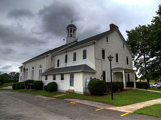
Graceham is an unincorporated community and a census-designated place (CDP) in Frederick County, Maryland, United States. Graceham is home to Graceham Moravian Church and Parsonage. Per the 2020 Census, the population was 243.
Crumpton is a census-designated place in Queen Anne's County, Maryland, United States. Crumpton is located along the Chester River, 5 miles (8.0 km) west-southwest of Millington. Crumpton has a post office with the ZIP code 21628.

Captains Cove is a census-designated place in Accomack County, Virginia. Per the 2020 census, the population was 1,544. Known as Captain's Cove Golf & Yacht Club, it is a recreational community located on the west shore of Chincoteague Bay, bordering Maryland to the north. While numerous families with children live here, it's largely a retirement community, with a median age of 51 and the largest age group being 60–64.

Marlboro Meadows is an unincorporated community and census-designated place (CDP) in Prince George's County, Maryland, United States. Per the 2020 census, the population was 3,655. It was newly delineated for the 2010 census prior to which the area was part of the Greater Upper Marlboro census-designated place.
Melwood is an unincorporated community and census-designated place (CDP) in Prince George's County, Maryland, United States. It was newly delineated for the 2010 census, at which time its population was 3,051. Per the 2020 census, the population was 3,977.
Butlertown is an unincorporated community and census-designated place in Kent County, Maryland, United States. Per the 2020 census, the population was 520.
Morgantown is a census-designated place (CDP) in Adams County, Mississippi, United States, located to the northeast of the city of Natchez. As of the 2020 census, it had a population of 1,334.
Robinhood is an unincorporated community and census-designated place in Rankin County, Mississippi, United States. Per the 2020 census, the population was 1,491.
Edisto is an unincorporated community and census-designated place in Orangeburg County, South Carolina, United States. Its population was 2,058 as of the 2020 census. U.S. Route 601 passes through the community.
Georgetown is an unincorporated community and census-designated place in western Kent County, Maryland, United States. Per the 2020 census, the population was 117. It should not be confused with the community of the same name 22 miles (35 km) to the northeast on the Kent/Cecil County border.
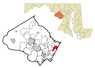
Ten Mile Creek is a census-designated place in Montgomery County, Maryland, United States. It was first listed as a CDP for the 2020 census, when it had a population of 1,012.
Chesapeake Landing is a census designated place in Kent County, Maryland, United States. Per the 2020 Census, the population was 472.
Wildewood is a planned community and census-designated place (CDP) in St. Mary's County, Maryland, United States. It is in east-central St. Mary's County, 7 miles (11 km) east of Leonardtown, the county seat, and 58 miles (93 km) southeast of Washington, D.C. It is bordered to the east by the unincorporated community of California.
Live Oak is an unincorporated community and census-designated place (CDP) in Horry County, South Carolina, United States. As of the 2020 census it had a population of 93.


