
Silver Spring is a census-designated place (CDP) in southeastern Montgomery County, Maryland, United States, near Washington, D.C. Although officially unincorporated, it is an edge city with a population of 81,015 at the 2020 census, making it the fifth-most populous place in Maryland after Baltimore, Columbia, Germantown, and Waldorf.

Aspen Hill is a census-designated place and an unincorporated area in Montgomery County, Maryland, United States. It is located 6 miles north of Washington D.C. Its population as of the 2020 census was 51,063.
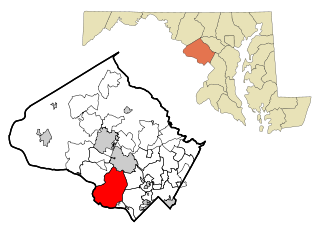
Clarksburg is a census-designated place and an unincorporated area in northern Montgomery County, Maryland, United States. It is located at the northern end of the Interstate 270 technology corridor, approximately four miles north of Germantown. As of the 2020 census, Clarksburg had a population of 29,051.
Potomac is an unincorporated community and census-designated place (CDP) in Montgomery County, Maryland. As of the 2020 census, it had a population of 47,018. It is named after the nearby Potomac River.

Sandy Spring is an unincorporated community in Montgomery County, Maryland, United States.

Germantown is an urbanized census-designated place in Montgomery County, Maryland, United States. With a population of 91,249 as of the 2020 census, it is the third most populous place in Maryland, after Baltimore and Columbia. Germantown is located approximately 28 miles (45 km) outside the U.S. capital of Washington, D.C., and is an important part of the Washington metropolitan area.

Interstate 370 (I-370) is a 2.54-mile (4.09 km) Interstate Highway spur route off I-270 in Gaithersburg, Maryland, to the western end of the Maryland Route 200 toll road at an interchange that provides access to the park and ride lot at the Shady Grove station on the Red Line of the Washington Metro. Despite the number, I-370 does not connect to I-70 itself. The road continues to the west of I-270 as Sam Eig Highway, a surface road. Along the way, I-370 has interchanges with MD 355 and Shady Grove Road. The freeway was completed in the late 1980s to connect I-270 to the Shady Grove station. I-370 was always part of the planned Intercounty Connector but was the only segment to be built at the time. The opening of MD 200 east of I-370 resulted in the truncation of I-370 to the interchange with MD 200 and the redesignation of the road leading into the Shady Grove station as MD 200A.

Barrie School is a progressive independent school for students age 12 months through Grade 12 located in an unincorporated area of Montgomery County, Maryland, outside of Washington, D.C. The school is within the Glenmont census designated place, has a Silver Spring postal address, and is in close proximity to Layhill. Barrie School is a nonprofit school with 501(c)(3) status.

The Capital Beltway is a 64-mile (103 km) auxiliary Interstate Highway in the Washington metropolitan area that surrounds Washington, D.C., the capital of the United States, and its inner suburbs in adjacent Maryland and Virginia. It is the basis of the phrase "inside the Beltway", used when referring to issues dealing with US federal government and politics. The highway is signed as Interstate 495 (I-495) for its entire length, and its southern and eastern half runs concurrently with I-95.

Maryland Route 200, also known as the Intercounty Connector or ICC, is an 18.8-mile-long (30.3 km), six-lane toll road in the U.S. state of Maryland. A controlled-access highway, it connects Gaithersburg in Montgomery County and Laurel in Prince George's County, both of which are suburbs of Washington, D.C. The ICC was one of the most controversial Maryland road projects; opposition to the highway stalled the project for decades, and construction did not begin until 60 years after the highway's initial approval.

Interstate 270 (I-270) is a 34.7-mile (55.8 km) auxiliary Interstate Highway in the U.S. state of Maryland that travels from I-495 just north of Bethesda in Montgomery County north to I-70 in the city of Frederick in Frederick County. It consists of the 32.6-mile (52.5 km) mainline as well as a 2.1-mile (3.4 km) spur that provides access to and from southbound I-495. I-270 is known as the Washington National Pike, and makes up the easternmost stretch of the Dwight D. Eisenhower Highway. Most of the southern part of the route in Montgomery County passes through suburban areas around Rockville and Gaithersburg that are home to many biotech firms. This portion of I-270 is up to 12 lanes wide and consists of a local–express lane configuration as well as high-occupancy vehicle lanes that are in operation during peak travel times. North of the Gaithersburg area, the road continues through the northern part of Montgomery County, passing Germantown and Clarksburg as a six- to eight-lane highway with an HOV lane in the northbound direction only. North of here, I-270 continues through rural areas into Frederick County and toward the city of Frederick as a four-lane freeway.

Georgia Avenue is a major north-south artery in Northwest Washington, D.C., and Montgomery County, Maryland. Within the District of Columbia and a short distance in Silver Spring, Maryland, Georgia Avenue is also U.S. Route 29. Both Howard University and Walter Reed Army Medical Center are located on Georgia Avenue.

Maryland Route 650 is a state highway in the U.S. state of Maryland. Known as New Hampshire Avenue for most of its length, the state highway runs 25.89 mi (41.67 km) from Eastern Avenue at the Washington, D.C. border north to MD 108 in Etchison. MD 650 serves as a major north-south commuter route in northwestern Prince George's County and eastern Montgomery County, connecting the District of Columbia with the residential suburbs of Takoma Park, Langley Park, Adelphi, Hillandale, White Oak, and Colesville. By contrast, the part of MD 650 north of Spencerville is a quiet rural road connecting several small communities along the northeastern fringe of Montgomery County.
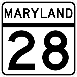
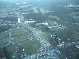
Maryland Route 28 is a state highway in the U.S. state of Maryland. The state highway runs 37.38 miles (60.16 km) from U.S. Route 15 in Point of Rocks east to MD 182 in Norwood. The western portion of MD 28 is a rural highway connecting several villages in southern Frederick County and western Montgomery County. By contrast, the eastern portion of the state highway is a major east–west commuter route, particularly within Gaithersburg and Rockville.

Westfield Wheaton, formerly known as Wheaton Plaza, is a 1.7 million square-foot, two-level indoor shopping mall in Wheaton, Maryland, north of Washington, D.C. It is owned by Unibail-Rodamco-Westfield and Its anchor stores include Macy’s, Target, JCPenney, Dick's Sporting Goods, and Costco.
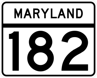
Maryland Route 182 is a state highway in the U.S. state of Maryland. Known for most of its length as Layhill Road, the highway runs 6.54 miles (10.53 km) from MD 97 in Glenmont north to MD 108 in Olney. MD 182 connects the northeastern Montgomery County communities of Glenmont, Layhill, Norwood, Sandy Spring, and Olney. The highway was constructed in the early 1920s. MD 182 was expanded to a four-lane divided highway from Glenmont to the site of its interchange with MD 200 in the late 1980s and early 1990s.

Ednor is an unincorporated community in Montgomery County, Maryland, United States.

Northwest Branch Anacostia River is a 21.5-mile-long (34.6 km) free-flowing stream in Montgomery County and Prince George's County, Maryland. It is a tributary of the Anacostia River, which flows to the Potomac River and the Chesapeake Bay.

Maryland's Legislative District 19 is one of 47 districts in the state for the Maryland General Assembly. The district currently consists of several Montgomery County communities, including portions of Laytonsville, Redland, Derwood, Shady Grove, Olney, Norbeck, Norwood, Leisure World, Aspen Hill, Layhill, Glenmont, Wheaton, Kemp Mill, and Four Corners.
Layhill is an unincorporated community and census-designated place in Montgomery County, Maryland, United States. According to the United States Census Bureau, Layhill had a population of 5,764 in 2020.

