Layhill, Maryland

Last updated

Layhill, Maryland
USA Maryland location map.svg
Red pog.svg
Coordinates: 39°05′14″N77°02′25″W / 39.08722°N 77.04028°W / 39.08722; -77.04028 [1]
CountryUnited States
StateMaryland
County Montgomery
Area
[2]
  Total1.60 sq mi (4.14 km2)
  Land1.59 sq mi (4.11 km2)
  Water0.01 sq mi (0.02 km2)
Elevation
[1]
384 ft (117 m)
Population
 (2020) [3]
  Total5,764
  Density3,627.44/sq mi (1,400.79/km2)
ZIP Code
Area code 301
FIPS code 24-46150
GNIS feature ID2583648 [1]

Layhill is an unincorporated community and census-designated place in Montgomery County, Maryland, United States. According to the United States Census Bureau, Layhill had a population of 5,764 in 2020. [4]

Contents

History

Early history

A land patent for Lay Hill was issued on August 17, 1716. [5] The size was recorded as 1,298 acres (2.0 sq mi; 5.3 km2). [5] The Northwest Branch ran through the tract, and the Norwood Turnpike passed its entire length. [5] As of 1879, several farms, including those of Abraham Van Horn and A.J. Cashell, were located there. [5] [6]

Oak Chapel

The Victorian-style church now called Oak Chapel was originally built in 1887. The fieldstone for the foundation was gathered by ox cart from neighboring land, while the timber was donated by George Bonifant Sr. from his nearby farm. A local saw mill made the boards. The chapel's cornerstone was laid on April 10, 1887. Lay Hill Methodist Episcopal Church, South was formally incorporated on October 26, 1886, and its first Board of Trustees consisted of George Bonifant, Andrew Johnson Cashell, John George Yewel Cashell, James William Godfrey, and Bennett Rufus Wilkerson. It was a congregation of the Methodist Episcopal Church, South, which had been formed in 1845 after the Methodist Episcopal Church had banned the ownership of enslaved people. [7]

Since its founding, Lay Hill shared its pastor with eleven other Methodist Episcopal churches in the area, and the pastor rode a horse between each of the churches. In 1904, the Colesville Charge was formed, with Lay Hill, Four Corners, and Colesville sharing one minister between them. In 1947, Lay Hill was appointed its own student minister. [7]

The adjacent church cemetery was dedicated by the Mullican family for use by the poor. The oldest headstone in the adjacent church cemetery is dated 1873. [7]

The church shortened its name to Lay Hill Methodist Church in 1939. It became Lay Hill United Methodist Church in 1965 at the time of the unification of the Methodist and Evangelical United Bretheran Churches. In 1968, the church filed articles of amendment to change its name to Oak Chapel Methodist Church, which it did in order to differentiate itself from the nearby Lay Hill Free Methodist Church on Bonifant Road, which had been founded in 1915. Two additions were made to the church, one in 1940 and one in 1970, both built lower on the hill so not to change the appearance of the church from the road. [7]

Just to the north of the church was Lay Hill Academy, a one-room public schoolhouse that opened after an 1839 state law established guidance for education for the first time in Maryland. In 1890, the schoolhouse was demolished and replaced by a larger school building. The school closed in 1926 when Glenmont School opened. The church bought the old Lay Hill Academy schoolhouse in 1945, and it used it as a kitchen until 1957, when it was demolished. [7]

Illegal brewery

On May 23, 1932, after weeks of investigation, Montgomery County police raided a house in Layhill and found a 20-horsepower steam boiler still and two barrels of mash. [8] The police officers arrested Alfred Crum of Kensington, charging him with possession of paraphernalia for manufacturing of intoxicants. [8] Crum was sentenced to four months imprisonment. [8]

Proposed cemetery

In 1952, H. Glenn Garvin planned to establish a cemetery on Bel Pre Road between Georgia Avenue and Layhill Road. [9] The Montgomery County Council denied the permit. [9]

Rodeo

A group of business people from Wheaton sponsored daily rodeos and stampedes off Layhill Road between July 2 and July 5, 1954. [10] [11] It was called the Flying E Ranch Rodeo, and 130 cowboys and 200 head of cattle performed for spectators. [12] [13] Members of local churches complained to police about the beer drinking. [14] Radie Evans, who operated the rodeo, had claimed to own the land for the rodeo when he applied for beer licenses. [14] The land turned out to be owned by Helen McGarvey Saul instead, and Evans was arrested and charged with perjury. [14]

Argyle Country Club

Argyle Country Club was originally located on Georgia Avenue in Petworth in the District of Columbia beginning in 1921. [15] After selling its land to a developer, the club moved to Four Corners, Maryland, on September 30, 1923. [16] The club operated in Four Corners until selling its land to be used for housing in 1945. [17] Argyle Country Club reopened at its present Layhill location on June 28, 1947. [18]

Residential development

The Layhill South neighborhood was developed in 1963. [19] Layhill Village [20] and Layhill Forest were built in 1965. [21] The Strathmore at Bel Pre neighborhood was built in 1968. [22] Chaddsford was developed in 1969. [23] Argyle Village subdivision was developed in 1985 adjacent to Argyle Country Club. [24] Parker Farm was developed in 1994. [25]

Plaza del Mercado

Plaza del Mercado, a shopping center built by Ziegler Corporation, [26] opened in October 1969. [27] Original stores included Giant Food, Peoples Drug, McDonald's, and Hallmark Card Shop. [27] Federal Realty Investment Trust bought Plaza del Mercado in October 2003. [28] An Aldi grocery store opened there on December 1, 2016. [29]

Widening of Layhill Road

In 1988, the Maryland State Highway Administration decided to widen Layhill Road. Residents were opposed when they learned that the widening would require destroying a 225-year-old 68-foot-tall oak tree that was a neighborhood landmark at the northwest corner of Layhill Road and Bel Pre Road. Forestry experts said the oak would not survive being moved across the street, and the State Highway Administration estimated that routing Layhill Road around the tree would cost $150,000. The plan continued, and the tree was cut down in October 1988. [30] [31] [32]

Geography

Layhill is in eastern Montgomery County, bordered by Cloverly to the northeast, Aspen Hill to the northwest, Glenmont to the south, and Colesville to the southeast. [33] The center of the community is the intersection of Maryland Route 182 (Layhill Road) and Bonifant Road/Bel Pre Road. MD 182 leads south 3 miles (5 km) to Wheaton and north 5 miles (8 km) to Olney. Rockville, the Montgomery county seat, is 6 miles (10 km) to the west, and downtown Washington, D.C., is 13 miles (21 km) to the south.

According to the U.S. Census Bureau, the Layhill CDP has a total area of 1.6 square miles (4.1 km2), of which 0.01 square miles (0.03 km2), or 0.56%, are water. [2]

Education

Bel Pre Elementary School, Strathmore Elementary School, and Glenallen Elementary School serve Layhill's elementary school-aged children.

Argyle Middle School is located in Layhill; some of Layhill's students are zoned to Colonel E. Brooke Lee Middle School.

High school-aged students living in Layhill are generally zoned to John F. Kennedy High School.

Alternatively, through the Downcounty Consortium, students who live in Layhill may apply to attend Montgomery Blair High School, Albert Einstein High School, John F. Kennedy High School, Northwood High School, or Wheaton High School. [34] [35]

Barrie School, a private school, has been located in Layhill since September 8, 1958. [36]

Transportation

The Intercounty Connector (Maryland Route 200) crosses the northern part of Layhill, [37] with access from Exit 10 (MD 182).

The Glenmont Metro station is 2 miles (3 km) south of Layhill. [38] This underground station, which opened on July 25, 1998, [39] is at the east end of the Red Line, and it has two large parking garages. From Glenmont, the Red Line heads south to downtown Silver Spring and to the District of Columbia before reentering Montgomery County and ending at Shady Grove. [40]

Demographics

Historical population
CensusPop.Note
2010 5,169
2020 5,76411.5%
source: [41]
2010–2020 [4]

As of the 2010 census, there were 5,169 people and 1,659 households residing in the Layhill CDP. [42] There were 1,775 housing units. The racial makeup of the community was 38.2% White, 34.9% African American, 0.2% Native American, 15.5% Asian, 0.0% Pacific Islander, and 3.6% from two or more races. [42] Hispanic or Latino people of any race consist of 17.6% of the population. [42]

There were 1,659 households, out of which 40.8% had children under the age of 18 living with them, 65.8% were married couples living together, 14.5% had a female householder with no husband present, 3.4% had a male householder with no wife present, and 16.3% were non-families. [43] 12.4% of all households were made up of individuals living alone, and 6.4% had someone living alone who was 65 years of age or older. [43] The average household size was 3.28, and the average family size was 3.56. [43]

Of adults age 25 or older, 86% had a high school degree, 53% had a bachelor's degree, and 28% had a graduate degree. [43] Civilian veterans were 8% of the population. [43]

22% of residents were born in Maryland, 40% were born elsewhere in the United States, and 38% were born abroad. [43] Of foreign-born residents, 58% were naturalized citizens of the United States. [43] Of foreign-born residents, 37% were born in Latin American, 36% were born in Asia, 24% were born in Africa, and 3% were born in Europe. [43]

Residents' ancestry includes Subsaharan African (10%), Irish (8%), English (7%), German (6%), American (4%), West Indian (3%), Polish (2%), Arab (2%), Swiss (2%), and Italian (1%). [43]

Residents' method of commuting to work included driving alone (64%), carpooling (11%), and public transportation (20%); 4% worked from home. [44] Residents' mean travel time to work is 38 minutes. [44]

The median income for a household in the census area was $120,184, and the median income for a family was $123,832. [44] 6.2% of the population and 5.0% of families were below the poverty line. [44] 8.4% of those under the age of 18 and 1.3% of those 65 and older were living below the poverty line. [44]

Points of interest

The Matthew Henson Trail starts at Layhill and continues for 4.2 miles (6.8 km) to Rock Creek in Rockville. [45]

The National Capital Trolley Museum, which opened in 1969, is nearby. [46]

Wat Thai Temple, a Buddhist temple, has been located in Layhill since 1995. [47] [48]

Related Research Articles

<span class="mw-page-title-main">Silver Spring, Maryland</span> Census-designated place in Maryland, United States

Silver Spring is a census-designated place (CDP) in southeastern Montgomery County, Maryland, United States, near Washington, D.C. Although officially unincorporated, it is an edge city with a population of 81,015 at the 2020 census, making it the fifth-most populous place in Maryland after Baltimore, Columbia, Germantown, and Waldorf.

<span class="mw-page-title-main">Kensington, Maryland</span> Town in Maryland, United States

Kensington is a town in Montgomery County, Maryland, United States. The population was 2,122 at the 2020 census. Greater Kensington encompasses the entire 20895 ZIP code, with a population of 19,753 in 2020.

<span class="mw-page-title-main">Wheaton, Maryland</span> Census-designated place in Maryland, United States

Wheaton is a census-designated place in Montgomery County, Maryland, United States, situated north of Washington, D.C., and northwest of downtown Silver Spring. Wheaton takes its name from Frank Wheaton (1833–1903), a career officer in the United States Army and volunteer from Rhode Island in the Union Army who rose to the rank of major-general while serving before, during and after the Civil War.

<span class="mw-page-title-main">Aspen Hill, Maryland</span> Census-designated place in Maryland, United States

Aspen Hill is a census-designated place and an unincorporated area in Montgomery County, Maryland, United States. It is located 6 miles north of Washington D.C. Its population as of the 2020 census was 51,063.

<span class="mw-page-title-main">Olney, Maryland</span> Census-designated place in Maryland, United States

Olney is a census-designated place and an unincorporated area in Montgomery County, Maryland, United States. It is located in the north central part of the county, ten miles (16 km) north of Washington, D.C.

<span class="mw-page-title-main">Elkridge, Maryland</span> Census-designated place in Maryland, United States of America

Elkridge is an unincorporated community and census-designated place (CDP) in Howard County, Maryland, United States. The population was 15,593 at the 2010 census. Founded early in the 18th century, Elkridge is adjacent to two other counties, Anne Arundel and Baltimore.

<span class="mw-page-title-main">Forest Glen, Maryland</span> Census-designated place in Maryland, United States

Forest Glen is a census-designated place (CDP) in Montgomery County, Maryland, United States. Its population was 6,897 as of the 2020 census.

<span class="mw-page-title-main">Potomac, Maryland</span> Census-designated place in Maryland, United States

Potomac is an unincorporated community and census-designated place in Montgomery County, Maryland, United States. As of the 2020 census, it had a population of 47,018. It is named after the nearby Potomac River. A part of the Washington metropolitan area, many Potomac residents work in nearby Washington, D.C., and Northern Virginia.

<span class="mw-page-title-main">Wheaton–Glenmont, Maryland</span> Former census-designated place in Maryland, United States

Wheaton–Glenmont was a census-designated place (CDP) in Montgomery County, Maryland, at the 2000 United States Census, at which time it had a population of 57,694. For the 2010 U.S. Census the area was split into the two census-designated places of Wheaton and Glenmont.

<span class="mw-page-title-main">Glenmont, Maryland</span> Census-designated place in Maryland, United States

Glenmont is an unincorporated community and census-designated place in Montgomery County, Maryland, United States. The United States Census Bureau had combined Glenmont with nearby Wheaton to create the census-designated place of Wheaton-Glenmont, from 2000 to 2010. It had a population of 16,710 in 2020.

<span class="mw-page-title-main">Barrie School</span> School in Silver Spring, Maryland, United States

Barrie School is a progressive independent school for students age 12 months through Grade 12 located in an unincorporated area of Montgomery County, Maryland, outside of Washington, D.C. The school is within the Glenmont census designated place, has a Silver Spring postal address, and is in close proximity to Layhill. Barrie School is a nonprofit school with 501(c)(3) status.

<span class="mw-page-title-main">Glenmont station</span> Washington Metro station

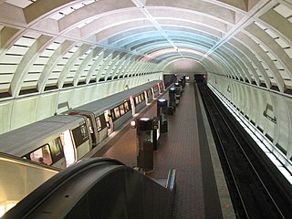
Glenmont station is a Washington Metro station in Montgomery County, Maryland on the Red Line. It is the eastern terminus of the Red Line.

<span class="mw-page-title-main">John F. Kennedy High School (Maryland)</span> Public secondary school in Silver Spring, Maryland, United States

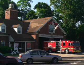
John F. Kennedy High School is a public high school located in Glenmont, Maryland.

<span class="mw-page-title-main">Wheaton High School</span> Public school in Silver Spring, Maryland, United States

Wheaton High School is a U.S. four-year public high school in Montgomery County, Maryland. It is located in the unincorporated Wheaton-Glenmont section of Montgomery County, near Silver Spring, about 5 miles north of Washington, D.C.

<span class="mw-page-title-main">Randolph Road</span> County highway in Montgomery County, Maryland, US

Randolph Road is a county highway in the U.S. state of Maryland. The highway is the major component of a mostly four- to six-lane 16.8-mile (27.0 km) highway spanning southern Montgomery County and northwestern Prince George's County that also includes Montrose Road, Josiah Henson Memorial Parkway, and Cherry Hill Road, and forms an important link between eastern Montgomery County and Rockville. Montrose Road begins at Maryland Route 189 in Potomac. The highway heads east through a junction with Interstate 270 (I-270) before the main course continues as Josiah Henson Memorial Parkway in North Bethesda. Josiah Henson Memorial Parkway continues through a junction with MD 355, east of which the highway becomes Randolph Road. Randolph Road intersects MD 586 and MD 185 in Wheaton, MD 97 in Glenmont, and MD 650 in Colesville. The highway continues southeast toward Fairland, where it meets U.S. Route 29. The highway continues from US 29 as Cherry Hill Road through an intersection with MD 212 in Calverton before reaching its eastern end at US 1 in College Park.

<span class="mw-page-title-main">Maryland Route 182</span> State highway in Montgomery County, Maryland

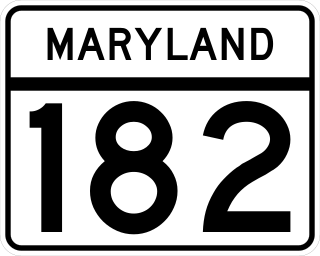
Maryland Route 182 is a state highway in the U.S. state of Maryland. Known for most of its length as Layhill Road, the highway runs 6.54 miles (10.53 km) from MD 97 in Glenmont north to MD 108 in Olney. MD 182 connects the northeastern Montgomery County communities of Glenmont, Layhill, Norwood, Sandy Spring, and Olney. The highway was constructed in the early 1920s. MD 182 was expanded to a four-lane divided highway from Glenmont to the site of its interchange with MD 200 in the late 1980s and early 1990s.

<span class="mw-page-title-main">Northwest Branch Anacostia River</span> Anacostia River tributary in Maryland, U.S.

Northwest Branch Anacostia River is a 21.5-mile-long (34.6 km) free-flowing stream in Montgomery County and Prince George's County, Maryland. It is a tributary of the Anacostia River, which flows to the Potomac River and the Chesapeake Bay.

<span class="mw-page-title-main">Maryland Legislative District 19</span> American legislative district

Maryland's Legislative District 19 is one of 47 districts in the state for the Maryland General Assembly. The district currently consists of several Montgomery County communities, including portions of Laytonsville, Redland, Derwood, Shady Grove, Olney, Norbeck, Norwood, Leisure World, Aspen Hill, Layhill, Glenmont, Wheaton, Kemp Mill, and Four Corners.

<span class="mw-page-title-main">Four Corners, Maryland</span> Neighborhood in Montgomery County, Maryland, United States

Four Corners is a neighborhood and census-designated place (CDP) in Montgomery County, Maryland, United States. Many residents consider the neighborhood a part of Silver Spring, to whose CDP it belonged until 2010. It had a population of 8,316 at the 2020 census.

References

  1. 1 2 3 U.S. Geological Survey Geographic Names Information System: Layhill, Maryland
  2. 1 2 "2022 U.S. Gazetteer Files: Maryland". United States Census Bureau. Retrieved June 7, 2023.
  3. "P1. Race – Layhill CDP, Maryland: 2020 DEC Redistricting Data (PL 94-171)". U.S. Census Bureau. Retrieved June 7, 2023.
  4. 1 2 "QuickFacts: Layhill CDP, Maryland". United States Census Bureau. Retrieved August 17, 2021.
  5. 1 2 3 4 Boyd, T.H.S. (1879). The History of Montgomery County, Maryland from Its Earliest Settlement in 1650 to 1879. Clarksburg, Maryland: Regional Publishing Company. p. 39. ISBN   0-8063-7954-5.
  6. "Death of Mr. A. J. Cashell". The Baltimore Sun. November 1, 1887. p. 6.
  7. 1 2 3 4 5 "Lay Hill Methodist Episcopal Church, South". Maryland Historical Trust. June 1991.
  8. 1 2 3 "Raid to Conviction Takes 30 MinutesL Montgomery Police Attack on Liquor Selling Gets Quick Results". The Washington Post. May 24, 1932. p. 17.
  9. 1 2 "Annual Assessments Backed in County". The Washington Post. December 10, 1952. p. 18.
  10. "Rodeo at Wheaton". The Washington Post. June 27, 1954. p. M3.
  11. "GIs Bidden to Rodeo". The Washington Post. June 30, 1954. p. 26.
  12. "Western Rodeo Opens Four-Day Show in Wheaton". The Washington Post. July 2, 1954. p. 25.
  13. "Rodeo Brings Bucking Broncs, Bulls and Burros". The Washington Post. July 4, 1954. p. 7.
  14. 1 2 3 "Perjury Laid To Operator Of Md. Rodeo". The Washington Post. August 8, 1954. p. M6.
  15. McCallum, Walter (August 27, 1945). "Argyle Club Soon May Be Sold: Two Get Aces at That Course". Washington Evening Star. p. 9.
  16. "Argyle Club Opens New Course Sunday". Washington Evening Star. September 29, 1923. p. 10.
  17. McCallum, Walter (January 20, 1946). "Layout of 6,241 Yards Mapped for Argyle: Manor Picks Board". Washington Evening Star. p. 20.
  18. "Argyle's New Golf Course to Open for Play Saturday". Washington Evening Star. June 26, 1967. p. 45.
  19. "Wagman Building on Layhill". The Washington Post. May 18, 1963. p. C2.
  20. "Notes on Area Realty and Construction". The Washington Post. February 20, 1965. p. D10.
  21. "Two Models at Layhill Forest". The Washington Post. September 25, 1965. p. D2.
  22. "Levitt Offering". The Washington Post. March 16, 1968. p. C1.
  23. "Chaddsford to Open Today". The Washington Post. June 28, 1969. p. D35.
  24. Argyle Village Homeowners Association: Welcome to Our Community, http://www.argylevillagehoa.com/argylevillagehoa/page.html, last accessed 3 Mar 2019.
  25. D.R. Horton (January 8, 1994). "It's Standard". The Washington Post. p. F3.
  26. "Area Realty and Building Notes". The Washington Post. June 22, 1968. p. C24.
  27. 1 2 "New Shopping Center Opens". The Washington Post. October 21, 1969. p. D9.
  28. "Q3 2003 FRT Earnings Release Conference Call - Final". Federal Document Clearing House. November 4, 2003.
  29. "Montgomery County Councilmember Nancy Navarro celebrates opening of new grocery store in Silver Spring". Montgomery County Council. December 1, 2016.
  30. Cytrynbaum, Pam (June 30, 1988). "Rallying Around Layhill Tree: Road Plan Threatens Md. Community's Roots". The Washington Post. p. D1.
  31. Cytrynbaum, Pam (August 19, 1988). "Montgomery to Lose a Living Landmark: 225-Year-Old Oak Will Be Cut Down for Layhill Road Widening". The Washington Post. p. D3.
  32. "225-year Giant Oak Bound for the Woodpile". The Washington Post. October 8, 1988. p. B1.
  33. "TIGERweb: Layhill Census Designated Place". Geography Division, U.S. Census Bureau. Retrieved June 7, 2023.
  34. "Choice Process in Detail for the Downcounty Consortium". Montgomery County Public Schools. Retrieved July 13, 2014.
  35. "Downcounty Consortium: Schools and Feeder Schools". Montgomery County Public Schools. Retrieved July 13, 2014.
  36. Austern, Helen (September 14, 1958). "Landon School Is on the Beam With Television". The Washington Post. p. F7.
  37. Thomson, Robert (November 20, 2011). "A driver's guide to using the ICC". The Washington Post. p. C2.
  38. "Metro – Rail – Glenmont". Washington Metropolitan Area Transit Authority. Archived from the original on July 5, 2014. Retrieved July 3, 2014.
  39. "Checking Out Metro's Newest". The Washington Post. July 26, 1998. p. B3.
  40. "Metro – Rail – Maps – Rail/Google Map". Washington Metropolitan Area Transit Authority. Archived from the original on June 3, 2010. Retrieved July 3, 2014.
  41. "Census of Population and Housing". U.S. Census Bureau . Retrieved March 19, 2007.
  42. 1 2 3 "Layhill CDP QuickFacts". United States Census Bureau. Archived from the original on July 14, 2014. Retrieved July 3, 2014.
  43. 1 2 3 4 5 6 7 8 9 "Elected Social Characteristics in the United States 2008–2012 American Community Survey 5-Year Estimates: Layhill CDP, Maryland". United States Census Bureau . Retrieved July 4, 2014.
  44. 1 2 3 4 5 "Elected Economic Characteristics in the United States 2008–2012 American Community Survey 5-Year Estimates: Layhill CDP, Maryland". United States Census Bureau . Retrieved July 4, 2014.
  45. Levine, Susan (April 10, 2003). "Planners Looking To Pave New Trail; Recommendation For Henson Path Splits Residents". The Washington Post. p. ME3.
  46. Eisen, Jack (October 16, 1969). "A Desire Named Streetcars: Something 'New' in Transit". Washington Post. p. B3.
  47. Ilustre, Jennie L. (April 30, 2003). "All Roads Lead to Temples To Celebrate the New Year". Asian Fortune.
  48. "About Us". Wat Thai, Washington, D.C. Archived from the original on September 16, 2014.