Georgia Avenue

Last updated
Small grayscale map of Washington DC showing Georgia Avenue Georgia Ave DC.PNG
Small grayscale map of Washington DC showing Georgia Avenue
Georgia Avenue (US 29) heading north in Silver Spring, Maryland Georgia Avenue - Silver Spring, Maryland 2022.jpg
Georgia Avenue (US 29) heading north in Silver Spring, Maryland

Georgia Avenue is a major north-south artery in Northwest Washington, D.C., and Montgomery County, Maryland. Within the District of Columbia and a short distance in Silver Spring, Maryland, Georgia Avenue is also U.S. Route 29. Howard University is located on Georgia Avenue.

Contents

Geography

Georgia Avenue begins north of Florida Avenue, which was the boundary of the Old City, and is a continuation of 7th Street. Traveling northward, the street passes Howard University and Fort Stevens. At Eastern Avenue, the road crosses into Montgomery County and passes through Silver Spring.

Where it crosses Colesville Road a mile into Maryland, Georgia Avenue splits off U.S. Route 29 and becomes Maryland State Highway 97. Georgia Avenue ends at the boundary with Howard County, where it becomes Roxbury Mills Road. [1] The total length of the road is about 24 miles (39 km), of which 5 miles (8 km) are in Washington, D.C.

History

The original Georgia Avenue was the road now named Potomac Avenue in Southwest and Southeast. Current-day Georgia Avenue was originally named 7th Street Extended and Brightwood Avenue.

Seventh Street Pike was built as a plank road from Boundary Avenue (now Florida Avenue) to the District Line in 1852. [2] Being a plank road, it was essentially paved with wooden planks that had to be replaced periodically due to rotting. [3] The road was also known as Brightwood Avenue.

A tollgate was located at current-day 6400 Georgia Avenue, at the corner of Georgia Avenue and Piney Branch Road NW. [4] Prominent residents living north of the tollgate decided to buy enough land to build a road to bypass the tollgate; this road became Piney Branch Road NW. [4]

The road was also the path of the Seventh Street Railway, which took riders from Brightwood to downtown. The railway consisted of cars drawn by horses, guided by metal tracks that protruded above the road. [5] [6] On April 12, 1890, Seventh Street Railway became electrically powered; its cable cars were powered by overhead electrical lines, and the cars themselves were guided by metal tracks embedded in the road. [5] [6] Other electrically powered railways were built elsewhere in the District in later years. [5]

In 1906, Georgia's senator Augustus Octavius Bacon was so dismayed that Georgia Avenue had become so neglected that he proposed to rename it Navy Yard Avenue and at the same time change the name of Brightwood Avenue to Georgia Avenue. [7] The Washington Evening Star editorialized against the bill. [8] While Senator Bacon's proposal did not come to fruition, Wisconsin's senator John Coit Spooner offered the same proposal again in 1907, [9] which also included changing the name of 16th Street to Washington Avenue. [10] Renaming of Brightwood Avenue was opposed by residents of Brightwood [7] and Park View. [11] The Business Men's Association also opposed the bill, saying it opposed the renaming of any avenue that was named in the original plan of the city. [12] The street renaming was stricken from the bill during the reconciliation process. [13] In 1908, Senator Bacon proposed the street renaming again. [14] The bill was opposed by residents of Brightwood, Brightwood Park, Takoma, and Petworth, the Southeast Washington Citizens' Association, and the East Washington Citizens' Association. [15] The Washington Evening Star also editorialized against the bill again, saying that changing the name of Brightwood Avenue "would remove all local significance from the name" and confuse those living in the neighborhood around what was then Georgia Avenue. [16] The 1908 appropriations bill ended up changing the name of Georgia Avenue to Potomac Avenue and Brightwood Avenue to Georgia Avenue. [17]

The portion between Glenmont and Norbeck was built in 1927. [18]

Future

The Montgomery County Planning Board is undertaking a concept study to provide "a design framework for future master plans and projects from the District of Columbia to Howard County." [19] The study covers each neighborhood in the corridor, examining pedestrian safety, urban design, and public transportation issues.

Event

Every June, Washington holds the D.C. Caribbean Carnival, which includes a parade down the lower portion of Georgia Avenue, an area that is home to many Caribbean immigrants. [20]

Transit service

Metrorail

Starting just north of the Silver Spring station, the Washington Metro Red Line runs roughly parallel to Georgia Avenue.

Metrorail stations on or near Georgia Avenue, from south to north, include:

Washington DC

Maryland

Metrobus

The following Metrobus routes travel along the street (listed from south to north):

Ride On

The following Ride On routes travel along the street (listed from south to north):

MARC

The following MARC train stop lies near the street:

The Wale song Chillin was filmed on Georgia Avenue.

The first three missions in Syphon Filter were set in Georgia Avenue.

Related Research Articles

<span class="mw-page-title-main">Pennsylvania Avenue</span> Street in Maryland and Washington, D.C., US

Pennsylvania Avenue is a primarily diagonal street in Washington, D.C., and Prince George's County, Maryland, that connects the United States Capitol with the White House and then crosses northwest Washington, D.C. to Georgetown. Traveling through southeast Washington from the Capitol, it enters Maryland, and becomes MD Route 4 and then MD Route 717 in Upper Marlboro, and finally Stephanie Roper Highway.

<span class="mw-page-title-main">Glenmont, Maryland</span> Census-designated place in Maryland, United States

Glenmont is an unincorporated community and census-designated place in Montgomery County, Maryland, United States. The United States Census Bureau had combined Glenmont with nearby Wheaton to create the census-designated place of Wheaton-Glenmont, from 2000 to 2010. It had a population of 16,710 in 2020.

<span class="mw-page-title-main">Red Line (Washington Metro)</span> Washington Metro rapid transit line

The Red Line is a rapid transit line of the Washington Metro system, consisting of 27 stations in Montgomery County, Maryland, and Washington, D.C., in the United States. It is a primary line through downtown Washington and the oldest and busiest line in the system. It forms a long, narrow "U," capped by its terminal stations at Shady Grove and Glenmont.

<span class="mw-page-title-main">Glenmont station</span> Washington Metro station

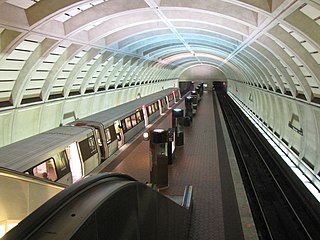
Glenmont station is a Washington Metro station in Montgomery County, Maryland on the Red Line. It is the eastern terminus of the Red Line.

<span class="mw-page-title-main">Takoma (Washington, D.C.)</span> Neighborhood of Washington, D.C.

Takoma, Washington, D.C., is a neighborhood in Washington, D.C. It is located in Advisory Neighborhood Commission 4B, in the District's Fourth Ward, within the northwest quadrant. It borders the city of Takoma Park, Maryland.

<span class="mw-page-title-main">Petworth (Washington, D.C.)</span> Place in District of Columbia, United States

Petworth is a residential neighborhood in the Northwest quadrant of Washington, D.C. It is bounded to the east by the Armed Forces Retirement Home and Rock Creek Cemetery, to the west by Arkansas Avenue NW, to the south by Rock Creek Church Road NW and Spring Road NW, and to the north by Kennedy Street NW.

<span class="mw-page-title-main">South Capitol Street</span>

South Capitol Street is a major street dividing the southeast and southwest quadrants of Washington, D.C., in the United States. It runs south from the United States Capitol to the D.C.–Maryland line, intersecting with Southern Avenue. After it enters Maryland, the street becomes Indian Head Highway at the Eastover Shopping Center, a terminal or transfer point of many bus routes.

<span class="mw-page-title-main">Brightwood (Washington, D.C.)</span> Place in the United States

Brightwood is a neighborhood in the northwestern quadrant of Washington, D.C. Brightwood is part of Ward 4.

<span class="mw-page-title-main">Maryland Route 97</span> State highway in Carroll, Howard, and Montgomery counties, Maryland, US

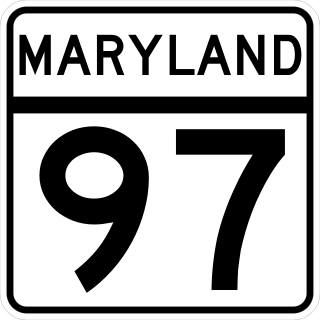
Maryland Route 97 (MD 97) is a state highway in the U.S. state of Maryland. The route runs 55.27 mi (88.95 km) from U.S. Route 29 (US 29) in Silver Spring, Montgomery County, north to the Pennsylvania border in Carroll County, where the road continues into that state as Pennsylvania Route 97 (PA 97). Throughout most of Montgomery County, MD 97 is known as Georgia Avenue, which continues south from the southern terminus along US 29 into Washington, D.C. It is a suburban four- to six-lane divided highway from Silver Spring north to Olney. From here, the route continues as a rural two-lane undivided road north through Brookeville and into Howard County. MD 97 continues through Carroll County where it passes through the county seat of Westminster. The route intersects many major roads, including Interstate 495 north of Silver Spring, MD 28 and MD 200 in Norbeck, I-70/US 40 near Cooksville, MD 26 in Dorsey Crossroads, and MD 27, MD 32, and MD 140 in the Westminster area.

<span class="mw-page-title-main">Fort Totten (Washington, D.C.)</span> Place in the United States

Fort Totten is a neighborhood located in Ward 5 of Northeast Washington, D.C.

<span class="mw-page-title-main">New Hampshire Avenue</span> Diagonal street in Washington, D.C.

New Hampshire Avenue is a diagonal street in Washington, D.C., beginning at the Kennedy Center and extending northeast for about 5 miles (8 km) and then continuing into Maryland where it is designated Maryland Route 650. New Hampshire Avenue, however, is not contiguous. It stops at 15th and W Streets NW and resumes again on the other side of Columbia Heights at Park Road NW, a few blocks from Georgia Avenue. New Hampshire Avenue passes through several Washington neighborhoods including Foggy Bottom, Dupont Circle, Petworth and Lamond-Riggs.

<span class="mw-page-title-main">Sixteenth Street Heights</span>

Sixteenth Street Heights is a large neighborhood of rowhouses, duplexes, and American Craftsman and American Foursquare detached houses in Northwest Washington, D.C.

<span class="mw-page-title-main">Metropolitan Railroad</span>

The Metropolitan Railroad was the second streetcar company to operate in Washington, D.C., the capital city of the United States. It was incorporated and started operations in 1864, running from the Capitol to the War Department and along H Street NW in downtown. It added lines on 9th Street NW, on 4th Street SW/SE, along Connecticut Avenue to Dupont Circle, to Georgetown, to Mount Pleasant and north along Georgia Avenue. In the late 19th century, it was purchased by the Washington Traction and Electric Company and on February 4, 1902, became a part of the Washington Railway and Electric Company.

Fort Stevens Ridge is a neighborhood in Northwest Washington, D.C. built during the 1920s. The neighborhood comprises about 50 acres (0.20 km2) and is very roughly bounded by Peabody Street, Fifth Street, Underwood Street, and Ninth Street. As of the 2010 census, the neighborhood had 2,597 residents. It was named for nearby Fort Stevens, a Civil War-era fort used to defend the nation's capital from invasion by Confederate soldiers.

Layhill is an unincorporated community and census-designated place in Montgomery County, Maryland, United States. According to the United States Census Bureau, Layhill had a population of 5,764 in 2020.

The Greenbelt–Glenmont Line, designated as Routes C7 & C9, was a former line operated by the Washington Metropolitan Area Transit Authority from September, 2000, all the way up to June 28, 2009, running between both Greenbelt of the Green Line & Glenmont station of the Red Line of the Washington Metro during weekday peak periods. The line mostly provided service between both Prince George's County & Montgomery County before being discontinued in 2009 due to low ridership.

<span class="mw-page-title-main">Georgia Avenue–Maryland Line</span>

The Georgia Avenue–Maryland Line, designated Route Y2, Y7, Y8, is a daily bus route operated by the Washington Metropolitan Area Transit Authority between Silver Spring station of the Red Line of the Washington Metro and MedStar Montgomery Medical Center in Olney or the Georgia Ave – ICC Park & Ride Lot (Y7). The line operates every 20 minutes during the weekday peak hour and weekend late nights, 30 minutes all other times on weekdays, and 40–45 minutes on weekends. Y2 trips are roughly 55 minutes long, Y7 trips are roughly 62 minutes long, and Y8 trips are roughly 70 minutes long. This route provides service along Georgia Avenue in Maryland providing service to multiple communities.

The Colesville–Ashton Line, designated Route Z2, is a weekday peak-hour bus route operated by the Washington Metropolitan Area Transit Authority between Olney and Silver Spring station of the Red Line of the Washington Metro. The line operates every 30–35 minutes during the weekday peak hours only. Route Z2 trips are roughly 60–70 minutes long.

<span class="mw-page-title-main">Georgia Avenue–7th Street Line</span>

The Georgia Avenue–7th Street Line, designated as Route 70, is a daily bus route that is operated by the Washington Metropolitan Area Transit Authority between Silver Spring station of the Red Line of the Washington Metro and Archives station of the Green and Yellow lines of the Washington Metro. With late night and early morning trips extending to L'Enfant Plaza station of the Blue, Orange, Silver, Green and Yellow Lines of the Washington Metro. The line operates every 12 minutes during the weekdays, 15 minutes during the weekends, and 20 minutes during the late nights. Trips are roughly 60 minutes.

References

  1. Google Maps, Georgia Avenue turns into Roxbury Mills Road
  2. Proctor, John Clagett, ed. (1930). Washington Past and Present. Vol. 1. New York: Lewis Historical Publishing Company Inc. p. 146.
  3. Proctor, John Cloggett (April 22, 1928). "Plank Road to Brightwood Was Historic Much Traveled Way". Sunday Star.
  4. 1 2 Proctor, John Clagett (September 20, 1942). "Eastern Star Has Golden Jubilee Here". Washington Evening Star. p. 29.
  5. 1 2 3 Proctor, John Clagett, ed. (1930). Washington Past and Present. Vol. 1. New York: Lewis Historical Publishing Company Inc. p. 164.
  6. 1 2 Proctor, John Clagett, ed. (1930). Washington Past and Present. Vol. 2. New York: Lewis Historical Publishing Company Inc. p. 731.
  7. 1 2 "East Washington Plans for Many Betterments". The Washington Post. September 9, 1906. p. A10. ProQuest   144680246.
  8. "Keep the Old Names" (editorial). Washington Evening Star. June 13, 1906. p. 4.
  9. "More Money for District". The Washington Post. February 14, 1907. p. 4. ProQuest   144742558.
  10. "Shaping District Bill". Washington Evening Star. February 21, 1907. p. 1.
  11. "Object to Change in Name". The Washington Post. May 3, 1908. p. E1. ProQuest   144838640.
  12. "Local Suffrage Talk". Washington Evening Star. February 16, 1907. p. 15.
  13. "Money for District". Washington Evening Star. February 27, 1907. p. 14.
  14. "Brightwood Avenue Renamed". Washington Evening Star. April 29, 1908. p. 10.
  15. "Citizens Object to Change". Washington Evening Star. May 2, 1908. p. 9.
  16. "Juggling the Street Names" (editorial). Washington Evening Star. April 29, 1908. p. 6.
  17. "Pare District Budget". The Washington Post. May 22, 1908. p. 4. ProQuest   144865482.
  18. "Oiling of Maryland Roads Progressing". Washington Evening Star. May 22, 1927. p. 65.
  19. Montgomery County Planning Board, Silver Spring, MD (2008). "Georgia Avenue Concept Study."
  20. "D.C. Caribbean Carnival". Archived from the original on 2018-03-24. Retrieved 2010-07-05.

38°59′05″N77°01′36″W / 38.984719°N 77.026637°W / 38.984719; -77.026637