North Capitol Street

Last updated

North Capitol Street
North Capitol Street NE
North Capitol Street NW
North Capitol Street sign - Washington DC.jpg
North Capitol Street sign
Maintained by DDOT
Location Washington, D.C., U.S.
South endD Street
Major
junctions
Massachusetts Avenue
H Street
US 50.svg US 50 (New York Avenue)
Florida Avenue
US 1.svg US 1 (Rhode Island Avenue)
New Hampshire Avenue
North end Eastern Avenue

North Capitol Street is a street in Washington, D.C. that separates the Northwest and Northeast quadrants of the city.

Contents

Route description

North Capitol Street begins at D Street in Lower Senate Park, between Louisiana and Delaware Avenues north of the United States Capitol. It continues in a straight line northward until it reaches Michigan Avenue, where it curves eastward and the westward around the Washington, D.C., VA Medical Center and the Armed Forces Retirement Home. For the 1.1 miles (1.8 km) between Irving Street and Clermont Drive, North Capitol Street is a limited-access road. North Capitol Street ceases to exist after Harewood Road. For 0.4 miles (0.64 km), it is named Clermont Drive. Beginning at Allison Street, Clermont Drive becomes Hawaii Avenue. Just after passing Buchanan Street, Hawaii Avenue turns back into North Capitol Street. North Capitol Street ceases to exist again at McDonald Place, and turns into Blair Road (which veers north-northeast). About 2,185 feet (666 m) due north of this transition, on Chillum Place just north of Kansas Avenue, North Capitol Street reappears. It continues to exist until it reaches Eastern Avenue, which marks the D.C.-Maryland border.

Current state

North Capitol Street divides the Northwest and Northeast quadrants of the District of Columbia and includes many Washington D.C. neighborhoods including Bloomingdale, Eckington, NoMa, and Truxton Circle. [1] The corridor is separated in two police districts (5D and 3D). Since the 1980s, North Capitol Street has suffered as one of highest crime areas in the District of Columbia, being ravaged by crack cocaine [2] and the effects of drug lords Rayful Edmond [3] and Tony Lewis who ran drug operations in Near Northeast and the unit block of Hanover Place NW. [4] The impact of this destruction is still seen throughout the community today. [5] While North Capitol Street services commuters as a thoroughfare, it is also a community of local residents, school children, and businesses.

History

By 1887, North Capitol Street ended at T Street. [6] The Commissioners of the District of Columbia decided to build a new segment of North Capitol Street from Boundary Street (now Florida Avenue) through Prospect Hill Cemetery in 1887. [7] [8] The plan was protested by about 400 German-Americans who owned cemetery lots at Prospect Hill Cemetery. [9] A committee of the U.S. House of Representatives investigated the matter. [10] The Commissioners ended up building North Capitol Street discontinuously, with one section running from Florida Avenue to T Street and another section going from Adams Street to the Armed Forces Retirement Home, in order to not go through the cemetery. [6]

In 1892, the House of Representatives considered extending North Capitol Street to the Armed Forces Retirement Home. [11] After continued oppositions of German-Americans living in the area, the House of Representatives passed a bill to extend North Capitol Street through the Prospect Hill Cemetery and continuing to the Armed Forces Retirement Home. [12] When fences were put up as part of the street extension, the directors of the Prospect Hill Cemetery tore down the fences. [13] Landowners filed a lawsuit to prevent the condemnation of land between T Street and Florida Street, which was owned by the Balbour family, and to prevent the condemnation of land in Prospect Hill Cemetery. [14] [15] The court examined the will of David Balbour, who had died ten years earlier, over who had inherited the land between T Street and Florida Avenue. [16] The court decided that the District could not simply acquire the cemetery's land through condemnation and that the land could only be purchased based on its worth for cemetery purposes. [17] Congress passed a bill to appropriate money to buy the land from the cemetery, and President Grover Cleveland signed the bill in 1897. [18] [19]

Landmarks on North Capitol Street

NPR building at the corner of L Street and North Capitol Street North capitol & L street NE.jpg
NPR building at the corner of L Street and North Capitol Street

Related Research Articles

<span class="mw-page-title-main">Northwest (Washington, D.C.)</span> Quadrant in the United States

Northwest is the northwestern quadrant of Washington, D.C., the capital of the United States, and is located north of the National Mall and west of North Capitol Street. It is the largest of the four quadrants of the city, and it includes the central business district, the Federal Triangle, and the museums along the northern side of the National Mall, as well as many of the District's historic neighborhoods.

<span class="mw-page-title-main">Eckington (Washington, D.C.)</span> Place in the United States

Eckington is a neighborhood in Northeast Washington, D.C., located south of the Prospect Hill and Glenwood Cemeteries. Eckington is less than one mile (1.6 km) southeast of Howard University and exactly one mile north of the United States Capitol. Eckington is also the home of the District of Columbia office of Sirius XM Radio.

<span class="mw-page-title-main">Constitution Avenue</span> Street in the city of Washington, D.C.

Constitution Avenue is a major east–west street in the northwest and northeast quadrants of the city of Washington, D.C., in the United States. It was originally known as B Street, and its western section was greatly lengthened and widened between 1925 and 1933. It received its current name on February 26, 1931, though it was almost named Jefferson Avenue in honor of Thomas Jefferson.

<span class="mw-page-title-main">Outdoor sculpture in Washington, D.C.</span>

There are many outdoor sculptures in Washington, D.C. In addition to the capital's most famous monuments and memorials, many figures recognized as national heroes have been posthumously awarded with his or her own statue in a park or public square. Some figures appear on several statues: Abraham Lincoln, for example, has at least three likenesses, including those at the Lincoln Memorial, in Lincoln Park, and the old Superior Court of the District of Columbia. A number of international figures, such as Mohandas Gandhi, have also been immortalized with statues. The Statue of Freedom is a 19½-foot tall allegorical statue that rests atop the United States Capitol dome.

<span class="mw-page-title-main">Bloomingdale (Washington, D.C.)</span> Place in the United States

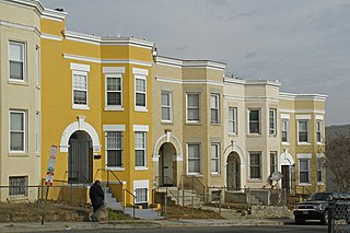
Bloomingdale is a neighborhood in the Northwest quadrant of Washington, D.C., less than two miles (3 km) north of the United States Capitol building. It is a primarily residential neighborhood, with a small commercial center near the intersection of Rhode Island Avenue and First Street NW featuring bars, restaurants, and food markets.

<span class="mw-page-title-main">Massachusetts Avenue (Washington, D.C.)</span> Major road in Washington, D.C., U.S.

Massachusetts Avenue is a major diagonal transverse road in Washington, D.C., and the Massachusetts Avenue Historic District is a historic district that includes part of it.

<span class="mw-page-title-main">Independence Avenue (Washington, D.C.)</span>

Independence Avenue is a major east-west street in the southwest and southeast quadrants of the city of Washington, D.C., in the United States, running just south of the United States Capitol. Originally named South B Street, Independence Avenue SW was constructed between 1791 and 1823. Independence Avenue SE was constructed in pieces as residential development occurred east of the United States Capitol and east of the Anacostia River. Independence Avenue SW received its current name after Congress renamed the street in legislation approved on April 13, 1934. Independence Avenue SW originally had its western terminus at 14th Street SW, but was extended west to Ohio Drive SW between 1941 and 1942. The government of the District of Columbia renamed the portion of the road in the southeast quadrant of the city in 1950.

<span class="mw-page-title-main">Streetcars in Washington, D.C.</span> Streetcars that existed in Washington until 1962

Streetcars in Washington, D.C. transported people across the city and region from 1862 until 1962.

<span class="mw-page-title-main">Florida Avenue</span>

Florida Avenue is a major street in Washington, D.C. It was originally named Boundary Street, because it formed the northern boundary of the Federal City under the 1791 L'Enfant Plan. With the growth of the city beyond its original borders, Boundary Street was renamed Florida Avenue in 1890.

<span class="mw-page-title-main">Fort Totten (Washington, D.C.)</span> Place in the United States

Fort Totten is a neighborhood located in Ward 5 of Northeast Washington, D.C.

<span class="mw-page-title-main">Truxton Circle</span> Place in the United States

Truxton Circle, sometimes known as East Shaw, is a neighborhood of Washington, D.C., located in Northwest D.C.

<span class="mw-page-title-main">Barney Circle</span> Neighborhood in the United States

Barney Circle is a small residential neighborhood located between the west bank of the Anacostia River and the eastern edge of Capitol Hill in southeast Washington, D.C., in the United States. The neighborhood is characterized by its sense of community, activism, walkability, and historic feel. The neighborhood's name derives from the eponymous former traffic circle Pennsylvania Avenue SE just before it crosses the John Philip Sousa Bridge over the Anacostia. The traffic circle is named for Commodore Joshua Barney, Commander of the Chesapeake Bay Flotilla in the War of 1812.

<span class="mw-page-title-main">Anna J. Cooper Circle</span>

Anna J. Cooper Circle is a traffic circle and park at the intersection of 3rd and T Streets, Northwest, in the historic LeDroit Park neighborhood of Washington, D.C. In 1983, the circle was named in honor of Anna Julia Haywood Cooper (1858–1964), an author, educator, feminist, and influential African American scholar who once lived in LeDroit Park. The circle is the city's only roundabout named after a woman and serves as a focal point for the LeDroit Park Historic District. The park includes a sign providing historical information about Cooper.

<span class="mw-page-title-main">Manor Park (Washington, D.C.)</span>

Manor Park is a neighborhood in Ward 4 of northwest Washington, D.C.

<span class="mw-page-title-main">Prospect Hill Cemetery (Washington, D.C.)</span> Historic cemetery, a.k.a., German Cemetery

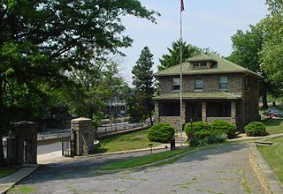
Prospect Hill Cemetery, also known as the German Cemetery, is a historic German-American cemetery founded in 1858 and located at 2201 North Capitol Street in Washington, D.C. From 1886 to 1895, the Prospect Hill Cemetery board of directors battled a rival organization which illegally attempted to take title to the grounds and sell a portion of them as building lots. From 1886 to 1898, the cemetery also engaged in a struggle against the District of Columbia and the United States Congress, which wanted construct a main road through the center of the cemetery. This led to the passage of an Act of Congress, the declaration of a federal law to be unconstitutional, the passage of a second Act of Congress, a second major court battle, and the declaration by the courts that the city's eminent domain procedures were unconstitutional. North Capitol Street was built, and the cemetery compensated fairly for its property.

<span class="mw-page-title-main">Quadrants of Washington, D.C.</span> Geographical quadrant

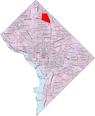
Washington, D.C., is administratively divided into four geographical quadrants of unequal size, each delineated by their ordinal directions from the medallion located in the Crypt under the Rotunda of the Capitol. Street and number addressing, centered on the Capitol, radiates out into each of the quadrants, producing a number of intersections of identically named cross-streets in each quadrant. Originally, the District of Columbia was a near-perfect square but contained more than one settlement; the Capitol was to be the center of the City of Washington. Thus, the Capitol was never located at the geographic center of the whole territory, which was eventually north of the Potomac River, consolidated into one city. As a result, the quadrants are of greatly varying size. Northwest is quite large, encompassing over a third of the city's geographical area, while Southwest is little more than a few neighborhoods, large parks, and a military base.

<span class="mw-page-title-main">Western Avenue (Washington, D.C.)</span>

Western Avenue is one of three boundary streets between Washington, D.C., and the state of Maryland. It follows a southwest-to-northeast line, beginning at Westmoreland Circle in the south and ending at Oregon Avenue NW in the north. It is roughly 3.5 miles (5.6 km) in length. First proposed in 1893, it was constructed somewhat fitfully from about 1900 to 1931.

Julius Germuiller, also spelled Julius Germüller, was a German-American architect from Washington, D.C. Throughout his 44-year career, he designed hundreds of buildings, mostly row houses. His work included designs in every quadrant of the city and a large number of his buildings are still extant. One of his works is listed on the National Register of Historic Places (NRHP).

<span class="mw-page-title-main">Finley General Hospital</span>

Finley General Hospital was a Union Army hospital which operated near Washington, D.C., during the Civil War. It operated from 1862 to 1865.

<span class="mw-page-title-main">Harewood General Hospital</span>

Harewood General Hospital was one of several purpose-built pavilion style hospitals operating in the Washington, D.C., area during the Civil War which rendered care to Union military personnel. A purpose-built pavilion style hospital, it was in use from September 4, 1862, to May 5, 1866.

References

  1. Eckington Civic Association, North Capitol Main Street. Eckington: A Neighborhood History. District of Columbia.
  2. Bertha Holiday, Paul Cerruti (2015). "Social and Architectural History of the Bloomingdale Neighborhood, Washington, DC" (PDF). Bloomingdale Civic Association.
  3. "Rayful Edmond", Wikipedia, December 18, 2019, retrieved January 23, 2020
  4. "In His Memoir, A Cocaine Kingpin's Son Sheds Light On D.C.'s Crack Era". WAMU. Retrieved January 23, 2020.
  5. Hermann, Peter (November 6, 2016). "Residents frustrated over troubled D.C. intersection where 4 were shot". The Washington Post.
  6. 1 2 "To Extend North Capitol Street". The Washington Post. January 12, 1893. p. 7.
  7. "North Capitol Street to be Extended". The Washington Post. October 20, 1887. p. 3.
  8. "The District in Congress: The Inquiry into the Extension of North Capitol Street". The Washington Post. March 4, 1888. p. 5.
  9. "North Capitol Street Extension: Lot Owners in Prospect Hill Cemetery Protesting". The Washington Post. January 5, 1888. p. 3
  10. "The District in Congress: The North Capitol Street Extension". The Washington Post. March 11, 1888. p. 5.
  11. "North Capitol Street: The Senate Extension Bill in the House--Costly Red Tape]". The Washington Post. May 12, 1892. p. 8.
  12. A Good District Day: Chairman Heard Puts Local Measures Through the House". The Washington Post. December 12, 1893.p. 2.
  13. Commissioner Powell Warned: Prospect Hill Cemetery Trustees Will Resist Further Encroachments". The Washington Post. January 10, 1894. p. 6.
  14. "To Restrain the Commissioners: Plaintiffs Prefer the Mandate of the Court of Appeals]". The Washington Post. October 5, 1894. p. 4.
  15. "No Low Grade Wanted: Citizens Object to the Eighteenth Street Changes". The Washington Post. October 5, 1894. p. 8.
  16. "Plaintiffs Must Show Proof: The David Moore Will Case Sent Back for a New Trial". The Washington Post. December 4, 1894. p. 8.
  17. "Two Bills Are Ready: House Committee Considers the District Calendar". The Washington Post. December 13, 1896. p. 3.
  18. "Progress on Tariff Bill: Specific Duties on Pulp and Ad Valorem on Printing Paper". The Washington Post. February 13, 1897. p. 4.
  19. "Approved by the President". The New York Times. February 23, 1897. p. 3.
Template:Attached KML/North Capitol Street
KML is from Wikidata