The community name is derived from aspentrees that once were found near the first post office in the area. The post office was located in a general store on what was then known as the Washington-Brookeville Pike (now the intersection of Connecticut and Georgia Avenues) and opened circa 1864.
History
In the 1920s and 1930s, Aspen Hill was known as being the location of Aspin Hill Memorial Park, one of three pet cemeteries then operating on the East Coast of the United States.[4][5][6] Burials at Aspen Hill Cemetery included dogs that had served the during World War I as well as the pets of area residents.[7] Memorial ceremonies honoring pets were often held there on World Day for Animals.[7][8][9]
In July 1950, Louis M. Denit sold 517 acres (2.1km2) of land in Aspen Hill to Gelman Construction Company for about $300,000.[10] Denit was a well-known attorney who specialized in banking and trust law.[11] Gelman Construction Company bought the land to build 2,450 three-bedroom ramblers, a shopping center, schools, playgrounds, and churches.[10] The homes were priced at less $10,000 each.[10]
In January 1955, Minnie Goodman sold 268 acres (1.1km2) of land in Aspen Hill to Metropolitan Homes, Inc.[12] The land was the last vacant tract of land of its size between Rockville and Wheaton.[12] Metropolitan Homes planned to build 12,000 homes, schools, shopping centers, and churches on the land.[12] Prices for the homes started at $15,000 each.[12]
Aspen Hill was one of the locations in which a fatal shooting took place in October 2002 as part of the Beltway sniper attacks.
Some addresses use Wheaton (20906),[13] notably in the Aspen Hill Shopping Center, while immediately across Aspen Hill Road at the Northgate Plaza Shopping Center, the addresses use Silver Spring (20906).[14] Immediately to the west across Connecticut Avenue, addresses use Rockville (20853).[15] As a result, crime statistics which are reasonably considered as belonging to Aspen Hill are buried in the statistics of three different areas. Aspen Hill straddles a corner where three statistical areas meet in what locals consider the commercial heart of Aspen Hill.
Other local resources such as the Montgomery Gazette and the Washington Post use a more broad definition. Generally speaking, if it is not a part of Manor Country Club or Leisure World, and is south of Norbeck Road and north of Veirs Mill Road, east of Rock Creek and west of Bel Pre Creek or Matthew Henson State Park or Matthew Henson Greenway, the local media consider it to be Aspen Hill.
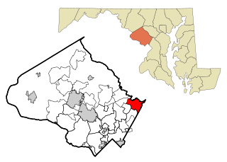
According to the United States Census Bureau, the community has a total area of 10.5 square miles (27km2), of which 10.5 square miles (27km2) is land and 0.1 square miles (0.26km2) (0.57%) is water.
Education
For the most accurate listing of schools visit the Aspen Hill Civic Association, Inc., Public Schools (AHCA) (2021). The Aspen Hill Civic Association, Inc. has been serving the community since 1985 for over 35 years in Aspen Hill, Montgomery County, Maryland. The Aspen Hill Civic Association, Inc. serves the following elementary schools within the AHCA boundaries: Wheaton Woods Elementary School, Rock Creek Valley Elementary School, Brookhaven Elementary School, Lucy Barnsley Elementary School, and Harmony Hills Elementary School. The Aspen Hill Civic Association, Inc. serves the following middle schools within the AHCA boundaries: Earle B Wood Middle School, and Parkland Middle School. Students within the AHCA boundaries area is served by both Rockville and Wheaton High Schools located outside the civic association boundaries. Other special or magnet schools serve residents as well.
As of the census[21] of 2010, there were 48,759 people, 16,697 households, and 11,959 families living in the community. The population density was 4,799.2 inhabitants per square mile (1,853.0/km2). There were 16,697 housing units at an average density of 1,590.2 per square mile (614.0/km2). The racial makeup of the area was 50.60% White, 21.70% Black or African American, 0.60% Native American, 10.9% Asian, 0.00% Pacific Islander, 11.5% from other races, and 4.6% from two or more races. 27.9% of the population were Hispanic or Latino of any race. 37.2 of the population were non-Hispanic whites and 13.4% were White Latinos. 20.9% were non-Hispanic African-Americans and less than 1% were Afro-Latino.
There were 18,187 households, out of which 33.3% had children under the age of 18 living with them, 53.7% were married couples living together, 14.1% had a female householder with no husband present, and 28.1% were non-families. 21.9% of all households were made up of individuals, and 7.6% had someone living alone who was 65 years of age or older. The average household size was 2.74 and the average family size was 3.18.
In the area the population was spread out, with 24.0% under the age of 18, 7.7% from 18 to 24, 31.8% from 25 to 44, 24.0% from 45 to 64, and 12.5% who were 65 years of age or older. The median age was 37 years. For every 100 females, there were 89.9 males. For every 100 females age 18 and over, there were 85.7 males.
The median income for a household in the area was $63,340, and the median income for a family was $73,736 (these figures had risen to $75,014 and $81,474 respectively as of a 2007 estimate[24]). Males had a median income of $44,341 versus $36,739 for females. The per capita income for the area was $27,905. About 4.6% of families and 6.8% of the population were below the poverty line, including 8.0% of those under age 18 and 6.4% of those age 65 or over.
Related Research Articles
Wheaton is a census-designated place in Montgomery County, Maryland, United States, situated north of Washington, D.C., and northwest of downtown Silver Spring. Wheaton takes its name from Frank Wheaton (1833–1903), a career officer in the United States Army and volunteer from Rhode Island in the Union Army who rose to the rank of major-general while serving before, during and after the Civil War.
Olney is a census-designated place and an unincorporated area in Montgomery County, Maryland, United States. It is located in the north central part of the county, ten miles (16 km) north of Washington, D.C.
Burtonsville is a census-designated place and an unincorporated area in Montgomery County, Maryland, United States. It is situated in the northeast corner of Montgomery County, right on the border of both Howard and Prince George's counties. It is considered a suburban town in the Washington D.C. Metro Area.
Adelphi is an unincorporated area and census-designated place in Prince George's County, Maryland, United States. Per the 2020 Census, the population was 16,823. Adelphi includes the following subdivisions; Adelphi, Adelphi Park, Adelphi Hills, Adelphi Terrace, Adelphi Village, Buck Lodge, Chatham, Cool Spring Terrace, Hillandale Forest, Holly Hill Manor, Knollwood, Lewisdale, and White Oak Manor.
Camp Springs is an unincorporated area and census-designated place (CDP) in Prince George's County, Maryland, United States. The population was 22,734 at the 2020 census. Camp Springs is not an official post office designation; the area is divided among the surrounding mailing addresses of Temple Hills, Fort Washington, Clinton, and Suitland.
Chillum is an unincorporated area and census-designated place in Prince George's County, Maryland, United States, bordering Washington, D.C., and Montgomery County.
Coral Hills is an unincorporated area and census-designated place (CDP) in Prince George's County, Maryland, United States. As of the 2020 census, the population was 9,997.
Fort Washington is an unincorporated area and census-designated place in Prince George's County, Maryland, United States. It borders the Potomac River, situated 20 miles south of downtown Washington, D.C. As of the 2020 census, it had a population of 24,261. The Fort Washington community is located west of Maryland Route 210, with some additional area to the east of the highway.
Glenarden is a city in Prince George's County, Maryland, United States. Per the 2020 census, the population was 6,402.
Glenn Dale is an unincorporated area and census-designated place (CDP) in Prince George's County, Maryland, United States. The population was 14,698 at the 2020 census. Glenn Dale is home to the Glenn Dale Hospital, an abandoned sanatorium, and the USDA Plant Introduction Station.
Landover Hills is a town in Prince George's County, Maryland, United States. Per the 2020 census, the population was 1,815. The town has a neighborhood named Defense Heights.
Largo, located within Greater Upper Marlboro, Maryland, is an unincorporated area and census-designated place in Prince George's County, Maryland, United States. The population was 11,605 at the 2020 census.
Marlow Heights is an unincorporated area and census-designated place (CDP) in Prince George's County, Maryland, United States. The population was 6,169 at the 2020 census. The Marlow Heights Shopping Center first opened in 1957, adjacent to the large community of Hillcrest Heights. It was joined ten years later, in 1967, by the two-level Iverson Mall, the Washington metropolitan area's first enclosed mall.
Mount Rainier is a city in Prince George's County, Maryland, United States, bordering Washington D.C. The population was 8,333 at the 2020 census. Mount Rainier is contained between the Northwest Branch Anacostia River, Cedar Lane Alley, and 34th Street to the north, 37th Street and 37th Place to the northeast, Upshur Street and Queens Chapel Road to the west, the CSX Capital Subdivision train tracks to the east, and Eastern Avenue NE to the south. Mount Rainier got its start as a streetcar suburb, when tracks were laid for the 82 Streetcar Line. According to local tradition, surveyors from the Pacific Northwest named the town, giving the streets names such as Shasta and Cascade. Historic U.S. 1 runs through the center of the town and serves as the main street and central business district.
Seat Pleasant is an incorporated city in Prince George's County, Maryland, United States, located immediately east of Washington D.C.. Per the 2020 census, the population was 4,522. Two state highways pass through the community — Maryland routes 704 and 214. The Washington Metro's Blue and Silver Lines are nearby. The Washington Commanders' stadium is east of Seat Pleasant, near the Capital Beltway (I-95/495).
Temple Hills is an unincorporated area and census-designated place (CDP) in Prince George's County, Maryland, United States. Temple Hills borders the communities of Hillcrest Heights, Marlow Heights, Camp Springs and Oxon Hill. Per the 2020 census, the population was 8,350.
Walker Mill is an unincorporated area and census-designated place (CDP) in Prince George's County, Maryland, United States. Per the 2020 census, the population was 12,187.
Calverton is an unincorporated area and census-designated place located on the boundary between Montgomery and Prince George's counties, Maryland, in the United States. At the 2020 census, it had a population of 17,316.
Lanham is an unincorporated community and census-designated place in Prince George's County, Maryland. As of the 2020 United States Census it had a population of 11,282. The New Carrollton station as well as an Amtrak station are across the Capital Beltway in New Carrollton, Maryland. Doctors Community Hospital is located in Lanham.
Glenmont is an unincorporated community and census-designated place in Montgomery County, Maryland, United States. The United States Census Bureau had combined Glenmont with nearby Wheaton to create the census-designated place of Wheaton-Glenmont, from 2000 to 2010. It had a population of 16,710 in 2020.
↑ "Pal, Old Dog, Joins Owners in Death". The Washington Post. Aug 16, 1928. p. 1.
↑ Wooten, Katherine Hinton. "Where Your Pets Lie Sleeping: The Aspin Hill Memorial Park in Washington, Fourth Largest of Its Kind in the Country, Contains the Bodies of Some Two Thousand Dumb Friends—Many Brought From Other Cities—Graves Are Marked With Elaborate Memorial Stones". The Washington Post. October 26, 1930. p. SM6.
↑ "Hope for Cat: Reward Awaiting Return, Dead or Alive: Spot in Cemetery Reserved". The Washington Post. April 8, 1933. p. 18.
1 2 "Rites Will Honor Pets at Cemetery". The Washington Post. October 3, 1936. p. X26.
↑ "Today Is World Day for Animals The Washington Post". October 3, 1943. p. M11.
↑ "Animal Lovers Pay Tribute To Dead Pets". The Washington Post. October 7, 1940. p. 13.
1 2 3 "Sold Near Wheaton Md." The Washington Post. July 23, 1950. p. R1.
↑ "Lawyer Left $900,000, Most to Wife". The Washington Post. March 29, 1957. p. B13.
1 2 3 4 "Md. Tract Bought for Homesites". The Washington Post. January 30, 1955. p. G1.
↑ "Home". Melvin J. Berman Hebrew Academy. Retrieved October 25, 2020. Harry A. Epstein Campus 13300 Arctic Avenue Rockville, MD 20853 - Compare to the map.
This page is based on this Wikipedia article Text is available under the CC BY-SA 4.0 license; additional terms may apply. Images, videos and audio are available under their respective licenses.