List of counties in Maryland

Last updated

Independent city and counties of Maryland
Map of maryland counties.jpg
Location State of Maryland
Number23 counties and 1 Independent city
Populations(Counties only): 19,303 (Kent) – 1,058,474 (Montgomery)
Areas(Counties only): 254 square miles (660 km2) (Howard) – 983 square miles (2,550 km2) (Dorchester)
Government
Subdivisions

There are 23 counties and one independent city in the U.S. state of Maryland. Though formally an independent city rather than a county, the City of Baltimore is considered the equal of a county for most purposes and is functionally a county-equivalent in most respects. Many of the counties in Maryland were named for relatives of the Barons Baltimore, who were the proprietors of the Maryland colony from its founding in 1634 through 1771. The Barons Baltimore were Catholic, and George Calvert, 1st Baron Baltimore, originally intended that the colony be a haven for English Catholics, though for most of its history Maryland has had a majority of Protestants. [1]

Contents

History

The last new county formation in Maryland occurred when Garrett County was formed in 1872 from portions of Allegany County. [2] However, there have been numerous changes to county borders since that time, most recently when portions of the city of Takoma Park that had previously been part of Prince George's County were absorbed into Montgomery County in 1997. [3]

Outside Baltimore (which is an independent city) the county is the default unit of local government. Under Maryland law, counties exercise powers reserved in most other states at the municipal or state levels, so there is little incentive for a community to incorporate. Many of the state's most populous and economically important communities, such as Bethesda, Silver Spring, Columbia, and Towson are unincorporated and receive their municipal services from the county. In fact, there are no incorporated municipalities at all in Baltimore County or Howard County. The county-equivalent is also the provider of public schools—school districts as a separate level of government do not exist in Maryland.

The City of Baltimore generally possesses the same powers and responsibilities as the counties within the state. It is an entity nearly surrounded by but separate from the County of Baltimore, which has its county seat in Towson.

The Federal Information Processing Standard (FIPS) code, which is used by the United States government to uniquely identify states and counties, is provided with each entry. [4] Maryland's code is 24, which when combined with any county code would be written as 24XXX. The FIPS code for each county links to census data for that county.

List of counties

County
FIPS code [5] County seat [2] [6] Est. [2] [6] Origin [2] Etymology [2] Flag
Seal
Population [7] Area [6] [7] Map
AlleganyCounty 001 Cumberland 1789Formed from part of Washington CountyFrom Lenape oolikhanna, which means "beautiful stream" Flag of Allegany County, Maryland.png Seal of Allegany County, Maryland.png 67,273430 sq mi
(1,114 km2)
Map of Maryland highlighting Allegany County.svg
Anne ArundelCounty 003 Annapolis 1650Formed from part of St. Mary's County Anne Arundell was the maiden name of the wife of Cecil Calvert, 2nd Baron Baltimore. Between 1654 and 1658 it was known as Providence County by Puritan settlers Flag of Anne Arundel County, Maryland.svg Seal of Anne Arundel County, Maryland.svg 594,582588 sq mi
(1,523 km2)
Map of Maryland highlighting Anne Arundel County.svg
BaltimoreCounty 005 Towson 1659Formed from unorganized territory Cecil Calvert, 2nd Baron Baltimore, first proprietor of the Maryland colony Flag of Baltimore County, Maryland.svg Seal of Baltimore County, Maryland.svg 844,703682 sq mi
(1,766 km2)
Map of Maryland highlighting Baltimore County.svg
BaltimoreCity 510 Baltimore City 1851Founded in 1729. Detached in 1851 from Baltimore County Cecil Calvert, 2nd Baron Baltimore, first proprietor of the Maryland colony Flag of Baltimore, Maryland.svg Seal of Baltimore, Maryland.svg 565,23992 sq mi
(238 km2)
Map of Maryland highlighting Baltimore City.svg
CalvertCounty 009 Prince Frederick 1654Formed as Patuxent County from unorganized territory. Renamed Calvert County in 1658The Calvert family; prior to 1658 it was called Patuxent County, after the Patuxent Indians, a branch of the Algonquians Flag of Calvert County, MD.svg Seal of Calvert County, Maryland.png 94,728345 sq mi
(894 km2)
Map of Maryland highlighting Calvert County.svg
CarolineCounty 011 Denton 1773From parts of Dorchester County and Queen Anne's CountyLady Caroline Eden, daughter of Charles Calvert, 5th Baron Baltimore Flag of Caroline County, Maryland.svg Seal of Caroline County, Maryland.svg 33,593326 sq mi
(844 km2)
Map of Maryland highlighting Caroline County.svg
CarrollCounty 013 Westminster 1837From parts of Baltimore County and Frederick County Charles Carroll of Carrollton, a representative to the Continental Congress and signatory of the Declaration of Independence Flag of Carroll County, Maryland.png Seal of Carroll County, Maryland.png 176,639452 sq mi
(1,171 km2)
Map of Maryland highlighting Carroll County.svg
CecilCounty 015 Elkton 1674From parts of Baltimore County and Kent CountyCecil is an Anglicized form of the first name of Cecil Calvert, 2nd Baron Baltimore Flag of Cecil County, Maryland.png Seal of Cecil County, Maryland.png 105,672418 sq mi
(1,083 km2)
Map of Maryland highlighting Cecil County.svg
CharlesCounty 017 La Plata 1658From unorganized territory Charles Calvert, 3rd Baron Baltimore, second proprietor of the Maryland colony Flag of Charles County, Maryland.svg Seal of Charles County, Maryland.svg 171,973643 sq mi
(1,665 km2)
Map of Maryland highlighting Charles County.svg
DorchesterCounty 019 Cambridge 1668From unorganized territory Dorchester in Dorset, England; the Earl of Dorset was a friend of the Calvert family Flag of Dochester County, Maryland.png Seal of Dorchester County, Maryland.png 32,879983 sq mi
(2,546 km2)
Map of Maryland highlighting Dorchester County.svg
FrederickCounty 021 Frederick 1748From part of Prince George's County Frederick Calvert, 6th Baron Baltimore, final proprietor of the Maryland colony 2023 flag of Frederick County, Maryland.svg Seal of Frederick County, Maryland.png 293,391667 sq mi
(1,728 km2)
Map of Maryland highlighting Frederick County.svg
GarrettCounty 023 Oakland 1872From part of Allegany County John Work Garrett, president of the Baltimore and Ohio Railroad Flag of Garrett County, Maryland.svg Seal of Garrett County, Maryland.svg 28,423656 sq mi
(1,699 km2)
Map of Maryland highlighting Garrett County.svg
HarfordCounty 025 Bel Air 1773From part of Baltimore County Henry Harford, illegitimate son of Frederick Calvert, 6th Baron Baltimore Flag of Harford County, Maryland.png Seal of Harford County, Maryland.svg 264,644527 sq mi
(1,365 km2)
Map of Maryland highlighting Harford County.svg
HowardCounty 027 Ellicott City 1851From parts of Anne Arundel County and Baltimore County John Eager Howard, an American Revolutionary War officer and governor of Maryland Flag of Howard County, Maryland.svg Seal of Howard County, Maryland.png 336,001254 sq mi
(658 km2)
Map of Maryland highlighting Howard County.svg
KentCounty 029 Chestertown 1642From unorganized territoryThe English county of Kent Flag of Kent County, Maryland.gif Seal of Kent County, Maryland.gif 19,303414 sq mi
(1,072 km2)
Map of Maryland highlighting Kent County.svg
MontgomeryCounty 031 Rockville 1776From part of Frederick County Richard Montgomery, an American Revolutionary War general Flag of Montgomery County, Maryland.svg Seal of Montgomery County, Maryland.svg 1,058,474507 sq mi
(1,313 km2)
Map of Maryland highlighting Montgomery County.svg
Prince George'sCounty 033 Upper Marlboro 1696From parts of Calvert County and Charles County Prince George of Denmark, the husband of Queen Anne of Great Britain Flag of Prince George's County, Maryland (1963-present).svg Seal of Prince George's County, Maryland.svg 947,430498 sq mi
(1,290 km2)
Map of Maryland highlighting Prince George's County.svg
Queen Anne'sCounty 035 Centreville 1706From parts of Talbot County Anne, Queen of Great Britain Flag of Queen Anne's County, Maryland.gif Seal of Queen Anne's County, Maryland.png 52,508510 sq mi
(1,321 km2)
Map of Maryland highlighting Queen Anne's County.svg
SomersetCounty 039 Princess Anne 1666From unorganized territory.Mary, Lady Somerset, sister-in-law of Cecil Calvert, 2nd Baron Baltimore Flag of Somerset County, Maryland.svg Seal of Somerset County, Maryland.png 24,910611 sq mi
(1,582 km2)
Map of Maryland highlighting Somerset County.svg
St. Mary'sCounty 037 Leonardtown 1637From unorganized territory. Was named Potomac County between 1654 and 1658. The Virgin Mary, first county named in a colony intended to be a haven for Catholics Flag of St. Mary's County, Maryland.png Seal of St. Mary's County, Maryland.png 115,281611 sq mi
(1,582 km2)
Map of Maryland highlighting St. Mary's County.svg
TalbotCounty 041 Easton 1662From part of Kent CountyGrace, Lady Talbot, sister of Cecil Calvert, 2nd Baron Baltimore Flag of Talbot County, Maryland.svg Seal of Talbot County, Maryland.png 37,823477 sq mi
(1,235 km2)
Map of Maryland highlighting Talbot County.svg
WashingtonCounty 043 Hagerstown 1776From part of Frederick County George Washington, first President of the United StatesNone Seal of Washington County, Maryland (1950-1988).png 155,813468 sq mi
(1,212 km2)
Map of Maryland highlighting Washington County.svg
WicomicoCounty 045 Salisbury 1867From parts of Somerset County and Worcester CountyThe Wicomico River; in Lenape, wicko mekee indicated "a place where houses are built", possibly in reference to a settlement Flag of Wicomico County, Maryland.gif Seal of Wicomico County, Maryland.png 104,800400 sq mi
(1,036 km2)
Map of Maryland highlighting Wicomico County.svg
WorcesterCounty 047 Snow Hill 1742From part of Somerset CountyMary Arundell, the wife of Sir John Somerset, son of Henry Somerset, 1st Marquess of Worcester, and sister of Anne Arundell, the wife of Cecil Calvert, 2nd Baron Baltimore Flag of Worcester County, Maryland.svg Seal of Worcester County, Maryland.png 54,171695 sq mi
(1,800 km2)
Map of Maryland highlighting Worcester County.svg

Defunct counties

CountyYears of existenceEtymology
Old Charles County1650–1654King Charles I of England
Durham County1669–1672The English County Durham
Old Worcester County1672–1685Mary Arundell, the wife of Sir John Somerset, son of the 1st Marquess of Worcester,
and sister of Anne Arundell, wife of Cecil Calvert, 2nd Baron Baltimore

See also

Related Research Articles

<span class="mw-page-title-main">Baltimore County, Maryland</span> County in Maryland, United States

Baltimore County is the third-most populous county in the U.S. state of Maryland. It is part of the Baltimore metropolitan area.

<span class="mw-page-title-main">Anne Arundel County, Maryland</span> County in Maryland, United States

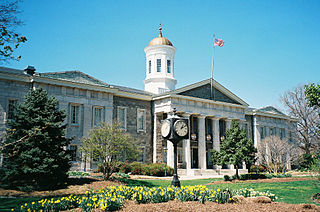
Anne Arundel County, also notated as AA or A.A. County, is located in the U.S. state of Maryland. As of the 2020 United States census, its population was 588,261, an increase of just under 10% since 2010. Its county seat is Annapolis, which is also the capital of the state. The county is named for Anne Arundell, Lady Baltimore, a member of the ancient family of Arundells in Cornwall, England, and the wife of Cecilius Calvert, 2nd Baron Baltimore (1605–1675), founder and first lord proprietor of the colony Province of Maryland.

<span class="mw-page-title-main">County (United States)</span> Subdivision used by most states in the United States

In the United States, a county or county equivalent is an administrative or political subdivision of a U.S. state or other territories of the United States which consists of a geographic area with specific boundaries and usually some level of governmental authority. The term "county" is used in 48 states, while Louisiana and Alaska have functionally equivalent subdivisions called parishes and boroughs, respectively. The specific governmental powers of counties vary widely between the states, with many providing some level of services to civil townships, municipalities, and unincorporated areas. Certain municipalities are in multiple counties; New York City is uniquely partitioned into five counties, referred to at the city government level as boroughs. Some municipalities have been consolidated with their county government to form consolidated city-counties, or have been legally separated from counties altogether to form independent cities. Conversely, those counties in Connecticut, Rhode Island, eight of Massachusetts's 14 counties, and Alaska's Unorganized Borough have no government power, existing only as geographic distinctions.

<span class="mw-page-title-main">Cecil Calvert, 2nd Baron Baltimore</span> English peer (1605–1675)

Cecil Calvert, 2nd Baron Baltimore was an English politician, peer and lawyer who was the first proprietor of Maryland. Born in Kent in 1605, he inherited the proprietorship after the death of his father, George Calvert, 1st Baron Baltimore, for whom it had been intended. Calvert proceeded to establish and manage the Province of Maryland as a proprietary colony for English Catholics from his English country house of Kiplin Hall in North Yorkshire.

A minor civil division (MCD) is a term used by the United States Census Bureau for primary governmental and/or administrative divisions of a county or county-equivalent, typically a municipal government such as a city, town, or civil township. MCDs are used for statistical purposes by the Census Bureau, and do not necessarily represent the primary form of local government. They range from non-governing geographical survey areas to municipalities with weak or strong powers of self-government. Some states with large unincorporated areas give substantial powers to counties; others have smaller or larger incorporated entities with governmental powers that are smaller than the MCD level chosen by the Census.

<span class="mw-page-title-main">Washington–Baltimore combined statistical area</span> Combined statistical area in the United States

The Washington–Baltimore combined metropolitan statistical area is a statistical area including the overlapping metropolitan areas of Washington, D.C. and of Baltimore. The region includes Central Maryland, Northern Virginia, three counties in the Eastern Panhandle of West Virginia, and one county in south-central Pennsylvania. It is the most educated, highest-income, and third-largest combined statistical area in the United States behind New York City–Newark, NJ and Los Angeles–Long Beach.

<span class="mw-page-title-main">Province of Maryland</span> British colony in North America (1634–1776)

The Province of Maryland was an English and later British colony in North America from 1634 until 1776, when the province was one of the Thirteen Colonies that joined in supporting the American Revolution against Great Britain. In 1781, Maryland was the 13th signatory to the Articles of Confederation. The province's first settlement and capital was in St. Mary's City, located at the southern end of St. Mary's County, a peninsula in the Chesapeake Bay bordered by four tidal rivers.

<span class="mw-page-title-main">Charles Calvert, 3rd Baron Baltimore</span> English peer and colonial administrator (1637–1715)

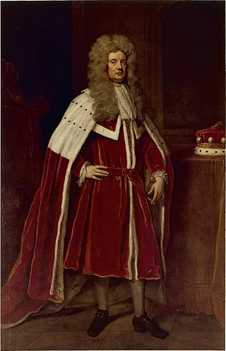
Charles Calvert, 3rd Baron Baltimore was an English peer and colonial administrator. He inherited the province of Maryland in 1675 upon the death of his father, Cecil Calvert, 2nd Baron Baltimore. He had been his father's Deputy Governor since 1661 when he arrived in the colony at the age of 24. However, Charles left Maryland for England in 1684 and would never return. The events following the Glorious Revolution in England in 1688 would cost Calvert his title to Maryland; in 1689 the royal charter to the colony was withdrawn, leading to direct rule by the British Crown. Calvert's political problems were largely caused by his Roman Catholic faith which was at odds with the established Church of England.

<span class="mw-page-title-main">Leonard Calvert</span> First governor of Maryland colony (1606-1647)

Leonard Calvert was the first proprietary governor of the Province of Maryland. He was the second son of The 1st Baron Baltimore (1579–1632), the first proprietor of Maryland. His elder brother Cecil (1605–1675), who inherited the colony and the title upon the death of their father George, April 15, 1632, appointed Leonard as governor of the Colony in his absence.

<span class="mw-page-title-main">Local government in the United States</span> Governmental jurisdictions below the level of the state

Most U.S. states and territories have at least two tiers of local government: counties and municipalities. Louisiana uses the term parish and Alaska uses the term borough for what the U.S. Census Bureau terms county equivalents in those states. Civil townships or towns are used as subdivisions of a county in 20 states, mostly in the Northeast and Midwest.

<span class="mw-page-title-main">Maryland Day</span> Holiday in Maryland, US

Maryland Day is a legal holiday in the U.S. state of Maryland. It is observed on the anniversary of the March 25, 1634, landing of the first European settlers in the Province of Maryland, the third English colony to be settled in British North America. On this day settlers from The Ark and The Dove first set foot onto Maryland soil, at St. Clement's Island in the Potomac River. The settlers were about 150 in number, departed from Gravesend on the Thames River downstream from London. Three Jesuit priests were collected from Cowes on the Isle of Wight in England where they avoided having to give the oath of allegiance and supremacy to the King. The colony's grant was renewed to Cecil Calvert, 2nd Baron Baltimore, (1605-1675), two years prior by Charles I of England, after first being given to his father Sir George Calvert, 1st Baron Baltimore, (1574-1632), along with the title of "Lord Baltimore", and a first grant of the Province of Avalon, in the Newfoundland Colony,, who had served the King in many official and personal capacities as Secretary of State, 1619-1625. In thanksgiving for the safe landing, Jesuit Father Andrew White celebrated the Mass for the colonists led by the younger brother of Lord Baltimore, Leonard Calvert, (1606-1647), who served as the first governor, and perhaps for the first time ever in this part of the world on the first landing at Blackistone Island, later known as St. Clement's Island off the northern shore of the Potomac River, which was the new border between the new colony and the earlier English settlements in Virginia) and erected a large cross. The landing coincided with the Feast of the Annunciation, a holy day honoring Mary, and the start of the new year in England's legal calendar. Maryland Day on 25 March celebrates the 1634 landing at St Clements. Later the colonists and their two ships sailed further back down river to the southeast to settle a capital at St. Mary's City near the point where the Potomac flows into the Chesapeake Bay.

In the United States, an independent city is a city that is not in the territory of any county or counties and is considered a primary administrative division of its state. Independent cities are classified by the United States Census Bureau as "county equivalents" and may also have similar governmental powers to a consolidated city-county or a unitary authority. However, in the case of a consolidated city-county, a city and a county were merged into a unified jurisdiction in which the county at least nominally exists to this day, whereas an independent city was legally separated from any county or merged with a county that simultaneously ceased to exist even in name.

References

  1. Brugger, Robert J. (1988). Maryland: A Middle Temperament, 1634–1980. Baltimore: Johns Hopkins Press. ISBN   0-8018-3399-X.
  2. 1 2 3 4 5 "Counties". Maryland Manual Online. Retrieved June 24, 2007.
  3. Brown, Deneen (June 28, 1997). "As Unification Nears, Takoma Park Residents Still a Divided People". The Washington Post. pp. A1. Retrieved June 24, 2007.
  4. "FIPS Publish 6-4". National Institute of Standards and Technology. Archived from the original on September 29, 2013. Retrieved April 11, 2007.
  5. "EPA County FIPS Code Listing". U.S. Environmental Protection Agency. Archived from the original on September 28, 2004. Retrieved February 23, 2008.
  6. 1 2 3 National Association of Counties. "NACo – Find a county". Archived from the original on October 25, 2007. Retrieved April 30, 2008.
  7. 1 2 "Maryland QuickFacts". U.S. Census Bureau. Retrieved April 21, 2024.