
"Tidewater" is a term for the north Atlantic Plain region of the United States.
"Tidewater" is a term for the north Atlantic Plain region of the United States.
Culturally, the Tidewater region usually includes the low-lying plains of southeast Virginia, northeastern North Carolina, southern Maryland and the Chesapeake Bay. [1] Speaking geographically, however, it covers about 50,000 square miles, from New York's Long Island in the north to the southernmost edge of North Carolina in the south, [2] [ better source needed ] an area that includes the state of Delaware and the Delmarva Peninsula.
The cultural Tidewater region got its name from the effects of the changing tides on local rivers, sounds, and the ocean. The area has a centuries-old cultural heritage that sets the Tidewater region apart from the adjacent inland parts of the United States, especially with respect to its distinctive dialects of English, which are gradually disappearing, [3] along with its islands and its receding shoreline. [4]
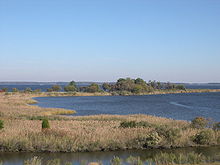
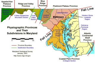
The tidewater region developed when sea level rose after the last ice age, resulting in the flooding of river valleys in the coastal plain. Such flooded river valleys now make up the tidewater since tides continue to affect water levels far inland, in some cases all the way west to the Fall Line. It is generally flat and low, with large expanses near the tidal shorelines composed of tidal marsh and swamp. Much of the area is covered with pocosin and the higher areas are used for agricultural farmlands. Geographically, in North Carolina and Virginia the Tidewater area is the land between the Suffolk Scarp and the Atlantic Ocean. In Maryland the Tidewater area is the flooded river areas below the Fall Line. The Hampton Roads area of Virginia is considered to be a Tidewater region. Southern Maryland [5] and the Eastern Shore, parts of Delaware round out the northern part of the region on the Chesapeake and Delaware Bays.
The term tidewater may be correctly applied to all portions of any area, including Virginia, where the water level is affected by the tides (more specifically, where the water level rises when the tide comes in). In the case of Virginia, the Tidewater region includes the land east of the Fall Line, the natural border with the Piedmont Region. It includes Hampton Roads, the rest of the Virginia Peninsula, the Middle Peninsula, the Northern Neck, and the Eastern Shore.
Planters in the early American colonies extended their tobacco and peanut productions above the Fall Line, where waterfalls or rapids mark the end of the Tidewater and the beginning of the foothill region known as the Piedmont.[ citation needed ]
Tidewater is host to flora commonly associated with the South Atlantic pine forests and lower Southeast Coastal Plain maritime flora, the latter found primarily in southeastern Virginia.
A distinctive non-rhotic accent of the Old South was spoken in the Tidewater coastal region of Virginia. Known as a Tidewater accent, it is best associated with upper-class white speakers of the 19th and early 20th centuries. In the actual islands of the Chesapeake themselves, a separate, rhotic accent survives among the locals, sometimes known as "Hoi Toider".

The Chesapeake Bay is the largest estuary in the United States. The Bay is located in the Mid-Atlantic region and is primarily separated from the Atlantic Ocean by the Delmarva Peninsula, including parts of the Eastern Shore of Maryland, the Eastern Shore of Virginia, and the state of Delaware. The mouth of the Bay at its southern point is located between Cape Henry and Cape Charles. With its northern portion in Maryland and the southern part in Virginia, the Chesapeake Bay is a very important feature for the ecology and economy of those two states, as well as others surrounding within its watershed. More than 150 major rivers and streams flow into the Bay's 64,299-square-mile (166,534 km2) drainage basin, which covers parts of six states, New York, Pennsylvania, Delaware, Maryland, Virginia, and West Virginia, and all of Washington, D.C.


U.S. Route 13 or U.S. Highway 13 (US 13) is a north–south United States Numbered Highway established in 1926 that runs for 518 miles (834 km) from Interstate 95 (I-95) just north of Fayetteville, North Carolina, to US 1 in the northeastern suburbs of Philadelphia, Pennsylvania, near Morrisville. In all, it traverses five states in the Atlantic coastal plain region. It follows the Atlantic coast more closely than does the main north–south U.S. Highway of the region, US 1. Due to this, its number is out of place on the general U.S. Highway numbering grid, as it should be running west of US 11 but does not. Its routing is largely rural, the notable exceptions being the Hampton Roads area in Virginia and the northern end of the highway in Delaware and Pennsylvania. It is also notable for being the main thoroughfare for the Delmarva Peninsula and carrying the Chesapeake Bay Bridge–Tunnel to it in Virginia.

The Chesapeake Bay Bridge–Tunnel is a 17.6-mile (28.3 km) bridge–tunnel that crosses the mouth of the Chesapeake Bay between Delmarva and Hampton Roads in the U.S. state of Virginia. It opened in 1964, replacing ferries that had operated since the 1930s. A major project to dualize its bridges was completed in 1999, and a similar project to dualize one of its tunnels is currently underway.

South Hampton Roads is a region located in the extreme southeastern portion of Virginia's Tidewater region in the United States with a total population of 1,191,937. It is part of the Virginia Beach-Norfolk-Newport News, VA-NC MSA, which itself has a population of 1,724,876.

The Eastern Shore of Maryland is a part of the U.S. state of Maryland that lies mostly on the east side of the Chesapeake Bay. Nine counties are normally included in the region. The Eastern Shore is part of the larger Delmarva Peninsula that Maryland shares with Delaware and Virginia.

The Choptank River is a major tributary of the Chesapeake Bay and the largest river on the Delmarva Peninsula. Running for 71 miles (114 km), it rises in Kent County, Delaware, runs through Caroline County, Maryland, and forms much of the border between Talbot County, Maryland, on the north, and Caroline County and Dorchester County on the east and south. It is located north of the Nanticoke River, and its mouth is located south of Eastern Bay. Cambridge, the county seat of Dorchester County, and Denton, the county seat of Caroline County, are located on its south shore.
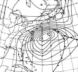
The Ash Wednesday Storm of 1962 occurred on March 5–9, 1962 along the mid-Atlantic coast of the United States. Also known as the Great March Storm of 1962, it was considered by the U.S. Geological Survey to be one of the most destructive storms ever to affect the mid-Atlantic states. Classified as a level 5 or Extreme Nor'easter by the Dolan-Davis scale for classification of Atlantic Nor'easters it was one of the ten worst storms in the United States in the 20th century. It lingered through five high tides over a three-day period, killing 40 people, injuring over 1,000, and causing hundreds of millions in property damage in six states. The storm also deposited significant snowfall over the Southeast, with a regional snowfall index of 12.663.
High Tider, Hoi Toider, or High Tide English is an American English dialect, or family of dialects, spoken in very limited communities of the South Atlantic United States, particularly several small islands and coastal townships. The exact areas include the rural "Down East" region of North Carolina, which encompasses the Outer Banks and Pamlico Sound—specifically Atlantic, Davis, Sea Level, and Harkers Island in eastern Carteret County, the village of Wanchese, and also Ocracoke—plus the Chesapeake Bay, such as Smith Island in Maryland, as well as Guinea Neck and Tangier Island in Virginia. High Tider has been observed as far west as Bertie County, North Carolina; the term is also a local nickname for any native resident of these regions.

U.S. Route 60 (US 60) in the Commonwealth of Virginia runs 303 miles (488 km) west to east through the central part of the state, generally close to and paralleling the Interstate 64 corridor, except for the crossing of the Blue Ridge Mountains, and in the South Hampton Roads area.
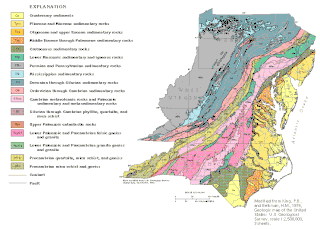
The geology of Delaware consists of two physiographic provinces located in the U.S. state of Delaware. They are the Atlantic Coastal Plain and the Piedmont.
Older Southern American English is a diverse set of American English dialects of the Southern United States spoken most widely up until the American Civil War of the 1860s, before gradually transforming among its White speakers, first, by the turn of the 20th century, and, again, following the Great Depression, World War II, and, finally, the Civil Rights Movement. By the mid-20th century, among White Southerners, these local dialects had largely consolidated into, or been replaced by, a more regionally unified Southern American English. Meanwhile, among Black Southerners, these dialects transformed into a fairly stable African-American Vernacular English, now spoken nationwide among Black people. Certain features unique to older Southern U.S. English persist today, like non-rhoticity, though typically only among Black speakers or among very localized White speakers.
The U.S. state of Maryland has a varied geography. It has an area of 12,406.68 square miles (32,133.2 km2) and is comparable in overall area with Belgium [11,787 square miles (30,530 km2)]. It is the 42nd largest and 9th smallest state and is closest in size to the state of Hawaii, the next smallest state. The next largest state, its neighbor West Virginia, is almost twice the size of Maryland. Maryland borders Pennsylvania to the north, Delaware to the northeast, the Atlantic Ocean to the east, and to the west and south by West Virginia and Virginia.

The natural environment of Virginia encompasses the physical geography and biology of the U.S. state of Virginia. Virginia has a total area of 42,774.2 square miles (110,784.67 km2), including 3,180.13 square miles (8,236.5 km2) of water, making it the 35th-largest state by area. Forests cover 65% of the state, wetlands and water cover 6% of the land in the state, while 5% of the state is a mixture of commercial, residential, and transitional.
The Atlantic Seaboard Fall Line, or Fall Zone, is a 900-mile (1,400 km) escarpment where the Piedmont and Atlantic coastal plain meet in the eastern United States. Much of the Atlantic Seaboard fall line passes through areas where no evidence of faulting is present.

The December 1992 nor'easter produced record high tides and snowfall across the northeastern United States. It developed as a low pressure area on December 10 over Virginia, and for two days it remained over the Mid-Atlantic states before moving offshore. In Maryland, the snowfall unofficially reached 48 in (1,200 mm); if verified, the total would have been the highest in the state's history. About 120,000 people were left without power in the state due to high winds. Along the Maryland coast, the storm was less severe than the Perfect Storm in the previous year, although the strongest portion of the storm remained over New Jersey for several days. In the state, winds reached 80 mph (130 km/h) in Cape May, and tides peaked at 10.4 ft (3.2 m) in Perth Amboy. The combination of high tides and 25 ft (7.6 m) waves caused the most significant flooding in the state since the Ash Wednesday Storm of 1962. Several highways and portions of the New York City Subway and Port Authority Trans-Hudson systems were closed due to the storm. Throughout New Jersey, the nor'easter damaged about 3,200 homes and caused an estimated $750 million in damage (1992 USD).

The January 1992 nor'easter was the second in a series of nor'easters in a 14-month period that produced strong winds, high tides, and flooding along the East Coast of the United States. It was a small, short-lived storm that was poorly forecast, intensifying rapidly on January 4 before striking the Eastern Shore of Virginia. The strongest quadrant of the storm moved over Delaware, and winds in the state reached 58 mph (93 km/h). The nor'easter weakened as it moved westward, and it dissipated over Virginia before the energy reformed and redeveloped offshore.
Notes
Geographically, Tidewater Virginia and Tidewater Maryland together form a triangle whose base extends from the Chesapeake Bay entrance westward through Hampton Roads and the lowlands south of the James River to Petersburg....
Bibliography
36°53′N76°28′W / 36.883°N 76.467°W
| Cities | |
|---|---|
| Counties | |
| Towns | |
| Sub-regions | |
| Topics | |
| See Also | |
Note: Cities are independent, not being part of any county | |
| International | |
|---|---|
| National | |