Map of Crystal Coast. The Crystal Coast extends southwestward from Cape Lookout to the New River Inlet.
In North Carolina, the Crystal Coast is an 85-mile stretch of coastline that extends from the Cape Lookout National Seashore, which includes 56 miles of protected beaches, southwestward to the New River. The Crystal Coast is a popular area with tourists and second-home owners in the summer, with a name coined by the Carteret County Tourism Development Authority.
The absolute boundaries of this coast are often disputed, but the main area includes all the major Carteret Countybeaches (those on Bogue Banks, which face south). It also includes eastern portions of Carteret County, such as Harkers Island, Down East and Shackleford Banks, as well as the northern Onslow Countybeaches (Bear Island/Hammock's Beach), and a few ports along the Intracoastal Waterway. Some tourism marketing describes the region as the Southern Outer Banks, to draw a connection to the main barrier islands of the Outer Banks.
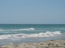
The crystal-water beaches that give the area its name
Beaches
The Carteret County Tourism Development Authority coined the name of Crystal Coast, to highlight the appeal of its waters. This body is also known as the Crystal Coast Tourism Authority.
The area has more than 100 restaurants and many hotels, including the Doubletree Atlantic Beach, the largest full-service hotel on the coast of North Carolina. Beach cottages, which are often rented out for a week during the summer, are also popular here, especially in Emerald Isle. Numerous properties are held as second homes by people with full-time residences in the interior of the state, such as in the cities of Kinston, Goldsboro and the capital Raleigh.
Many areas in this region have public access to the beaches, with one of the most popular being an area known as "The Circle" in central Atlantic Beach. It is a collection of shops, houses and amusement rides along the ocean at the end of the causeway from the bridge to Morehead City. Redevelopment is replacing the central area of rides with high-rise apartments, new restaurants, and shops.
Diving and fishing
Diving and fishing also attract visitors to the Crystal Coast. This is one of the two spots in North America where the warm waters of the Gulf Stream approach the coastline, creating a "wreck diver's dream" with near-perfect conditions, according to Scuba Diving magazine. The North Carolina coast is known as the "Graveyard of the Atlantic;" more than 2,000 vessels are recorded as having sunk along here.
During World War II, German U-boats frequently targeted and sank merchant vessels in this area. The clear warm waters enable divers to view them 100 feet beneath the sea. In the 21st century, the Lionfish, a venomous non-native invasive species with sharp spiny fins and brick red bands covering its body, has been found in these waters, alarming conservationists. Lionfish were previously thought to inhabit only the tropical and subtropical waters of the South Pacific, Indian Ocean and the Red Sea. Diving activities include underwater photography clinics as well as shark and spear fishing dives.
The proximity of the Gulf Stream makes the Crystal Coast a popular fishing destination. The warm waters provide this area with the longest fishing season on the Atlantic coast. One of the largest fishing tournaments in the world, the Big Rock Blue Marlin Tournament, is run from Morehead City. Other fish caught along the Crystal Coast include bluefin tuna, yellowfin tuna, red drum, false albacore, sea trout, striped bass, cobia, sailfish, dolphin and wahoo. Several private charters operate fishing excursions. Headboat fishing trips can take up to 100 people, making them more affordable for more families.
Morehead City and Atlantic Beach
Entrance to Fort Macon
The North Carolina Seafood Festival has been held for over 30 years and is one of the largest festivals in the state. It is held near the port of Morehead City; the other state port is Wilmington.
In Atlantic Beach, Fort Macon is a major draw for its Civil War history; it is the second most-visited state park in North Carolina. During the war, the fort changed hands several times between Union and Confederate forces. Afterward it fell into disrepair but was restored in 1934 as a part of the state park system, during a period of public investment in infrastructure and parks. During World War II, the federal government took over the fort, using it to protect a number of important nearby facilities.
Returned to the state, the park preserves a protected beach. One of three North Carolina aquariums is at Pine Knoll Shores, with the other two in Manteo and Fort Fisher. All three have been recently renovated and enlarged. The “Living Shipwreck” features a life-sized replica of a German U-352 submarine and Blackbeard’s infamous ship, the Queen Anne's Revenge, which was found nearby off the coast a decade ago.
Beaufort and Harkers Island
Historic Beaufort and Down East Carteret County are known for their history and culture. Beaufort (pronounced "Bo-furt") is the third-oldest Anglo-European town in North Carolina, after Bath and New Bern. It is the site of the North Carolina Maritime Museum, the official repository for all the artifacts discovered on the Queen Anne’s Revenge. Displays include seashells from around the world, with 5,000 specimens from more than 100 countries. At the museum's Watercraft Center, volunteers build and restore boats in an effort to preserve the Crystal Coast's tradition of "backyard boat-building."
On nearby Harkers Island, the Core Sound Waterfowl Museum displays and helps preserve the island residents' practice of decoy carving. Skilled artisans carve a perfect replica of different varieties of ducks from a block of wood. Residents used the wooden ducks as decoys during duck hunting season. Trips to visit the black-and-white diamond pattern lighthouse at Cape Lookout can also be made from Beaufort and Harker's Island. Nearby Shackleford Banks is home to herds of feral horses, known as Bankers.
Neighbors
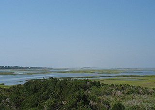
The Core Sound shoreline communities east of Beaufort are known as the "Down East" area of North Carolina. As they are in Carteret County, they are technically part of the Crystal Coast. The beaches and islands north of here, starting with Portsmouth Island and Ocracoke, are known as the Outer Banks.
South of the Crystal Coast is an undeveloped stretch of coast around the mouth of the New River that is part of the Camp Lejeune military base near Jacksonville. The next developed area to the south is Topsail Island in Onslow County.
Places
Map of Carteret County, North Carolina with Municipal and Township labels
Carteret County is a county located in the U.S. state of North Carolina. As of the 2020 census, the population was 67,686. Its county seat is Beaufort. The county was created in 1722 as Carteret Precinct and gained county status in 1739. It was named for Sir George Carteret, one of the 17th century English Lords Proprietor, or for his descendant and heir John Carteret, 2nd Earl Granville.
Atlantic Beach is a town in Carteret County, North Carolina, United States. It is one of the five communities located on Bogue Banks. The population was 1,364 at the 2020 census.
Beaufort is a town in and the county seat of Carteret County, North Carolina, United States. Established in 1713 and incorporated in 1723, Beaufort is the fourth oldest town in North Carolina . On February 1, 2012, Beaufort was ranked as "America's Coolest Small Town" by readers of Budget Travel Magazine.
Harkers Island is a census-designated place (CDP) in Carteret County, North Carolina, United States. The population of Harkers Island was 1,207 at the 2010 census. Harkers Island is unincorporated and receives most public services, including law enforcement and public education, from Carteret County. A membership cooperative provides the island with electric and water services. Major industries on the island include fishing, boat building, tourism, and waterfowl decoy carving.
Morehead City is a port town in Carteret County, North Carolina, United States. The population was 8,661 at the 2010 census. Morehead City celebrated the 150th anniversary of its founding on May 5, 2007. It forms part of the Crystal Coast.
Pine Knoll Shores is a coastal town in Carteret County, North Carolina, United States. The population was 1,388 at the 2020 census. One of North Carolina's state aquariums is located here.
Cape Lookout National Seashore preserves a 56-mile (90-km) long section of the Southern Outer Banks, or Crystal Coast, of North Carolina, USA, running from Ocracoke Inlet on the northeast to Beaufort Inlet on the southwest. Three undeveloped barrier islands make up the seashore - North and South Core Banks and Shackleford Banks. The seashore includes two historic villages on Core Banks, Shackleford's wild horses, and the Cape Lookout Lighthouse, which has a black-and-white diamond pattern. A visitor center for the seashore is located on Harkers Island.
Salter Path is an unincorporated community in Carteret County, North Carolina, United States. A Crystal Coast community, it lies on Bogue Banks as an enclave within Indian Beach.
Cape Lookout is the southern point of the Core Banks, one of the natural barrier islands on the Atlantic coast of North Carolina. It delimits Onslow Bay to the west from Raleigh Bay to the east. Core Banks and Shackleford Banks have been designated as parts of the Cape Lookout National Seashore.
The Outer Banks are a 200 mi (320 km) string of barrier islands and spits off the coast of North Carolina and southeastern Virginia, on the east coast of the United States. They line most of the North Carolina coastline, separating Currituck Sound, Albemarle Sound, and Pamlico Sound from the Atlantic Ocean. A major tourist destination, the Outer Banks are known for their wide expanse of open beachfront and the Cape Hatteras National Seashore. The seashore and surrounding ecosystem are important biodiversity zones, including beach grasses and shrubland that help maintain the form of the land.
Shackleford Banks is a barrier island system on the coast of Carteret County, North Carolina. It contains a herd of feral horses, scallop, crabs and various sea animals, including summer nesting by loggerhead turtles. It is a tourist and beach camping site.
The Cape Lookout Lighthouse is a 163-foot-high lighthouse located on the southern Outer Banks of North Carolina. It flashes every 15 seconds and is visible at least 12 miles out to sea and up to 19 miles. It is one of the very few lighthouses that operate during the day. It became fully automated in 1950. The Cape Lookout Lighthouse is the only such structure in the United States to bear the checkered daymark, intended not only for differentiation between similar light towers, but also to show direction. The center of the black diamonds points in a north-south direction, while the center of the white diamonds points east-west.
Bogue Banks form a 21-mile (34 km) barrier island off the mainland of North Carolina in Carteret County. The island, separated from the mainland by Bogue Sound, runs east to west, with the ocean beaches facing due south. Bogue Banks is the only island on the Carteret County shore that has been developed with housing: numerous communities are located on the island and can be accessed by one of two bridges across Bogue Sound, either from Morehead City to Atlantic Beach, which is the more heavily traveled bridge, or from Cape Carteret to Emerald Isle. The communities of Bogue Banks are the most prominent of the Crystal Coast. NC 58 traverses a majority of the island's length. There are several hotels that dot the island, but most of the land contains private houses, some of which are rented out during the summer, or maritime forest. Stores and other commercial properties are limited to the five main communities.
The Inner Banks is a neologism made up by developers and tourism promoters to describe the inland coastal region of eastern North Carolina. Without historical precedent, the term "Inner Banks" is an early 21st-century construct that is part of an attempt to rebrand the mostly agrarian coastal plain east of I-95 as a more attractive region for visitors and retirees.
Bogue Sound is a lagoon in the state of North Carolina separating the Bogue Banks, a 21-mile-long (34 km) barrier island, from the mainland. The sound is part of North Carolina's "Crystal Coast", a tourism marketing term that is also used interchangeably with the term "Southern Outer Banks." It is the southwestern-most sound among the interconnected series of sounds along the Outer Banks that starts in the northeast at Currituck Sound.
Barden Inlet is the southernmost of the Outer Banks water inlets. Located just northwest of Cape Lookout in the U.S. state of North Carolina, the inlet connects Onslow Bay of the Atlantic Ocean with Core Sound. It separates the Shackleford Banks from the Core Banks.
Eastern North Carolina is the region encompassing the eastern tier of North Carolina, United States. It is known geographically as the state's Coastal Plain region. Primary subregions of Eastern North Carolina include the Sandhills, the Lower Cape Fear, the Crystal Coast, the Inner Banks and the Outer Banks. It is composed of the 41 most eastern counties in the state. Cities include Greenville, Jacksonville, Wilmington, Rocky Mount and North Carolina's first capital New Bern.
Diamond City was a settlement on the eastern end of Shackleford Banks, in Carteret County, North Carolina, United States.
The Back Sound is a lagoon in eastern North Carolina. Running on an east–west axis, the sound separates Shackleford Banks to the south from the mainland and Harkers Island to the north. At the sound's eastern end lies Cape Lookout and Core Sound, while on the west end lies the Crystal Coast community of Beaufort and Bogue Sound. Barden Inlet at the eastern end, and Beaufort Inlet on the western end connect the sound to Onslow Bay. Much of the islands in the sound are protected as part of the Rachel Carson Estuarine Reserve, set aside for the protection of Banker horses.
The Core Banks are barrier islands in North Carolina, part of the Outer Banks and Cape Lookout National Seashore. Named after the Coree tribe, they extend from Ocracoke Inlet to Cape Lookout, and consist of two low-relief narrow islands, North Core Banks and South Core Banks, and, since September 2011, two smaller islands. New Drum Inlet, Old Drum Inlet and Ophelia Inlet now separate the islands. The Core Banks are now uninhabited. However, Portsmouth, at the north end of the North Core Banks, was once a substantial port, and Cape Lookout Village, about one and half miles south of the Cape Lookout Lighthouse, contains the historic Lookout Life-Saving Station, a U.S. Coast Guard Station, and several island homes.
This page is based on this Wikipedia article Text is available under the CC BY-SA 4.0 license; additional terms may apply. Images, videos and audio are available under their respective licenses.