Swain County, North Carolina

Last updated

Swain County
The modern Swain County, N.C., courthouse and administrative building.jpg
Swain County Courthouse
Swain County seal.png
Motto(s): 
"A natural gem set in the Great Smoky Mountains."
"Live here. Play here. Thrive here."
Map of North Carolina highlighting Swain County.svg
Location within the U.S. state of North Carolina
North Carolina in United States.svg
North Carolina's location within the U.S.
Coordinates: 35°34′N83°28′W / 35.57°N 83.47°W / 35.57; -83.47
CountryFlag of the United States.svg United States
StateFlag of North Carolina.svg  North Carolina
Founded1871
Named for David L. Swain
Seat Bryson City
Largest community Cherokee
Area
  Total540.25 sq mi (1,399.2 km2)
  Land527.73 sq mi (1,366.8 km2)
  Water12.52 sq mi (32.4 km2)  2.32%
Population
 (2020)
  Total14,117
  Estimate 
(2023)
13,916
  Density26.75/sq mi (10.33/km2)
Time zone UTC−5 (Eastern)
  Summer (DST) UTC−4 (EDT)
Congressional district 11th
Website www.swaincountync.gov

Swain County is a county located on the far western border of the U.S. state of North Carolina. As of the 2020 census, the population was 14,117. [1] Its county seat is Bryson City. [2]

Contents

Four rivers flow through the mountainous terrain of Swain County: the Nantahala River, Oconaluftee River, Tuckaseegee River, and the Little Tennessee River. Their valleys were occupied for thousands of years by various societies of indigenous peoples, including the South Appalachian Mississippian culture era, and the historic Cherokee people. Native Americans, mostly members of the federally recognized Eastern Band of Cherokee Indians, comprise 29% of the population in Swain County.

History

Former Swain County Courthouse in Bryson City Swain-county-courthouse-nc1.jpg
Former Swain County Courthouse in Bryson City

This area was occupied for thousands of years by cultures of indigenous peoples, who successively settled in the valleys of the three rivers and their tributaries. During the Woodland and South Appalachian Mississippian culture period, the latter beginning about 1000 CE, the peoples built earthwork platform mounds as their central public architecture. The more influential villages were each organized around a single mound with smaller villages nearby. The earliest European explorers, including two Spanish expeditions of the mid-to-late 16th century, are believed to have encountered Mississippian chiefdoms in some parts of the interior of the Southeast.

The historic Cherokee people emerged as a culture, and they became the primary occupants of a large homeland taking in what is now known as western Virginia, western North and South Carolina, southeastern Tennessee, northeast Georgia and northern Alabama. Numerous Cherokee towns were located along the Tuckaseegee River in this area, including Kituwa above the confluence with the Little Tennessee River. It is considered the Cherokee 'mother town'. The Eastern Band of Cherokee Indians (EBCI) acquired the Kituwa mound and former town site in 1996, and preserve it as sacred ground.

After the American Revolutionary War, more European Americans moved into this territory, seeking new lands west of the Appalachian Mountains. They came into increasing conflict with the Cherokee and other tribes whose territory they encroached on. Under President Andrew Jackson, Congress passed the Indian Removal Act of 1830, to force the Five Civilized Tribes out of the Southeast. He used federal army forces to round up and accompany most of the Cherokee to Indian Territory west of the Mississippi River (the area was later admitted in 1907 as the state of Oklahoma).

Population growth was slow in the more isolated Swain County. It was not organized by European Americans until 1871 during the Reconstruction era, when it was formed from parts of Jackson and Macon counties. It was named for David L. Swain, governor of North Carolina from 1832 to 1835 during the time of Indian Removal, and president of the University of North Carolina from 1835 to 1868.

Present-day Bryson City, designated as the county seat, developed on both sides of the Tuckaseegee River, which passes and completely surrounds the Bryson City Island Park. After that, it enters Fontana Lake and flows into the Little Tennessee River.

In 1868 the federal government recognized the Eastern Band of Cherokee Indians, made up of people who had stayed at the time of removal and their descendants. In the 1870s, they purchased within what is now Swain County the land area that became known the "Qualla Boundary" land trust. [3] [4] They are the only federally recognized tribe in North Carolina.

Geography

Swain County, North Carolina
Interactive map of Swain County
Oconaluftee River in Cherokee Oconaluftee River in Swain Co., NC IMG 4884.JPG
Oconaluftee River in Cherokee

According to the U.S. Census Bureau, Swain county has a total area of 540.25 square miles (1,399.2 km2), of which 527.73 square miles (1,366.8 km2) is land and 12.52 square miles (32.4 km2) (2.32%) is water. [5]

The county is located in far Western North Carolina in the Great Smoky Mountains. It holds more of the Great Smoky Mountains National Park than any other county in North Carolina or Tennessee. The highest point in the county is Clingmans Dome, elevation 6,643 feet, located on the NC/TN border. Clingman's is the third-highest peak in North Carolina. A walkable observation tower is located on its summit. The highest mountain in North Carolina and in the United States east of the Mississippi River is Mt. Mitchell, 6,684 feet, located northeast of Asheville, North Carolina in Yancey County. [6]

Three rivers ultimately feed the Little Tennessee River, which flows through the mountains into Tennessee. The Nantahala River is one of the most popular whitewater rafting rivers in the nation. [7] It is a tributary of the Little Tennessee River.

Cherokee reserve

The Oconaluftee River flows through Swain County and the town of Cherokee, where the federally recognized Eastern Band of Cherokee Indians is based. Their Qualla Boundary occupies territory in both Swain and Jackson counties. The Oconaluftee is a tributary of the Tuckaseegee River. Ancient Cherokee towns were located along both of these rivers. The Tuckaseegee flows into the Little Tennessee River before it leaves North Carolina. It also had important Cherokee towns, each developed around an earthwork mound. The Cherokee built their communal townhouse on top of these mounds.

National protected areas

State and local protected areas/sites

Major water bodies

Adjacent counties

Major highways

Major infrastructure

Demographics

Historical population
CensusPop.Note
1880 3,784
1890 6,57773.8%
1900 8,40127.7%
1910 10,40323.8%
1920 13,22427.1%
1930 11,568−12.5%
1940 12,1775.3%
1950 9,921−18.5%
1960 8,387−15.5%
1970 7,861−6.3%
1980 10,28330.8%
1990 11,2689.6%
2000 12,96815.1%
2010 13,9817.8%
2020 14,1171.0%
2023 (est.)13,916 [1] −1.4%
U.S. Decennial Census [9]
1790–1960 [10] 1900–1990 [11]
1990–2000 [12] 2010 [13] 2020 [1]

2020 census

Swain County racial composition [14]
RaceNumberPercentage
White (non-Hispanic)8,54160.5%
Black or African American (non-Hispanic)1020.72%
Native American 4,03028.55%
Asian 530.38%
Pacific Islander 100.07%
Other/Mixed 7895.59%
Hispanic or Latino 5924.19%

As of the 2020 census, there were 14,117 people, 5,620 households, and 3,615 families residing in the county.

2000 census

At the 2000 census, [15] there were 12,968 people, 5,137 households, and 3,631 families residing in the county. The population density was 25 people per square mile (9.7 people/km2). There were 7,105 housing units at an average density of 14 units per square mile (5.4 units/km2). The racial makeup of the county was 66.33% White, 1.70% Black or African American, 29.03% Native American, 0.15% Asian, 0.01% Pacific Islander, 0.49% from other races, and 2.28% from two or more races. 1.47% of the population were Hispanic or Latino of any race. 16.3% were of American, 8.0% Irish, 7.6% Scots-Irish, 6.9% German and 6.6% English ancestry according to Census 2000. 95.2% spoke English, 2.9% Cherokee and 1.3% Spanish as their first language.

There were 5,137 households, out of which 30.00% had children under the age of 18 living with them, 52.30% were married couples living together, 13.90% had a female householder with no husband present, and 29.30% were non-families. 25.80% of all households were made up of individuals, and 11.10% had someone living alone who was 65 years of age or older. The average household size was 2.44 and the average family size was 2.91.

In the county, the population was spread out, with 24.30% under the age of 18, 8.30% from 18 to 24, 26.70% from 25 to 44, 25.40% from 45 to 64, and 15.30% who were 65 years of age or older. The median age was 39 years. For every 100 females there were 94.60 males. For every 100 females age 18 and over, there were 91.20 males.

The median income for a household in the county was $28,608, and the median income for a family was $33,786. Males had a median income of $26,570 versus $20,722 for females. The per capita income for the county was $14,647. About 13.30% of families and 18.30% of the population were below the poverty line, including 25.60% of those under age 18 and 19.10% of those age 65 or over.

Politics, law and government

Politics

Swain has voted Republican the last six Presidential elections, but historically has been a swing county, with no candidate from either major party obtaining under 37 percent of the county's vote between 1976 and 2012, and no margin larger than twelve percentage points occurring in any election between 1984 and 2012. In 2016 Donald Trump won the county by twenty-three percentage points with the typical strong anti-Democratic swing of most counties in Appalachia, though his margin decreased in the 2020 election. Swain was solidly Democratic during the Third Party System, but the Populist movement dramatically increased the success of progressive Republicans between 1896 and 1928. However, the victory in the county of Progressive Party candidate Theodore Roosevelt in 1912 and subsequent dominance of liberal Democrats like Franklin D. Roosevelt and Adlai Stevenson suggest that the county's voters were drawn more to the relatively progressive agendas of these candidates than they were to any party label.

United States presidential election results for Swain County, North Carolina [16]
Year Republican Democratic Third party
No.%No.%No.%
2020 4,16158.87%2,78039.33%1271.80%
2016 3,56558.21%2,19635.86%3635.93%
2012 2,97651.96%2,61845.71%1342.34%
2008 2,90050.02%2,80648.40%921.59%
2004 2,59351.41%2,41947.96%320.63%
2000 2,22450.89%2,09747.99%491.12%
1996 1,44438.80%1,86950.21%40910.99%
1992 1,64037.88%2,11748.89%57313.23%
1988 1,79549.52%1,82150.23%90.25%
1984 2,01250.02%2,00049.73%100.25%
1980 1,45741.39%1,98756.45%762.16%
1976 1,60842.64%2,15157.04%120.32%
1972 2,05264.45%1,10134.58%310.97%
1968 1,49445.86%1,22737.66%53716.48%
1964 1,53440.07%2,29459.93%00.00%
1960 2,11249.31%2,17150.69%00.00%
1956 2,02653.04%1,79446.96%00.00%
1952 1,68046.29%1,94953.71%00.00%
1948 1,38941.25%1,90856.67%702.08%
1944 1,50541.63%2,11058.37%00.00%
1940 1,42537.04%2,42262.96%00.00%
1936 2,08444.31%2,61955.69%00.00%
1932 1,89343.78%2,41255.78%190.44%
1928 2,48459.04%1,72340.96%00.00%
1924 2,17854.85%1,76944.55%240.60%
1920 2,23960.96%1,43439.04%00.00%
1916 1,12857.64%82942.36%00.00%
1912 22011.93%76641.54%85846.53%

County government

Board of Commissioners

Swain County is governed by an elected Board of Commissioners. The County Manager oversees the day-to-day management of the county and supervises the administration of all County offices, departments, boards, commissions and agencies. The county manager attends all meetings of the Board of Commissioners, recommends measures that he considers expedient, and executes decisions made by the Board.

Swain County is a member of the regional Southwestern Commission council of governments.

Qualla Boundary government

The town of Cherokee is within the Qualla Boundary, land purchased by the Eastern Band of Cherokee Indians in the 1870s. [17] It has its own government, consisting of an elected chief and elected council members from each community within the tribe. The tribe is considered sovereign and only adheres to its own laws and the laws of the federal government. This allows the town of Cherokee to have a casino, despite casinos being outlawed in North Carolina. This was conditional on the adoption of a tribal-state gaming compact agreed to by both the tribe and the state, as well as approved by the federal government.

Policing and law enforcement

The Swain County Sheriff provides court protection, jail administration, patrol and detective services for the unincorporated areas of the county. Bryson City has a municipal police department.

Education

Swain County Schools serves all of the county except for the part in the Qualla Boundary, which is in Cherokee Central Schools. [18] Swain County High School serves the former and Cherokee Central High School serves the latter.

Media

The Smoky Mountain Times is published in Bryson City. [19] In 1889 and 1890 the community was served by the Swain County Herald. [20]

Communities

Map of Swain County with municipal and township labels Map of Swain County North Carolina With Municipal and Township Labels.PNG
Map of Swain County with municipal and township labels

Town

Census-designated places

Unincorporated communities

Townships

See also

Related Research Articles

<span class="mw-page-title-main">Jackson County, North Carolina</span> County in North Carolina, United States

Jackson County is a county located in the western part of the U.S. state of North Carolina. As of the 2020 census, the population was 43,109. Since 1913, its county seat has been Sylva, which replaced Webster.

<span class="mw-page-title-main">Graham County, North Carolina</span> County in North Carolina, United States

Graham County is a county located in the U.S. state of North Carolina. As of the 2020 census, the population was 8,030, making it the third-least populous county in North Carolina. Its county seat is Robbinsville.

<span class="mw-page-title-main">Cherokee County, North Carolina</span> County in North Carolina, United States

Cherokee County is the westernmost county in the U.S. state of North Carolina. It borders Tennessee to its west and Georgia to its south. As of the 2020 census, the population was 28,774. The county seat is Murphy.

<span class="mw-page-title-main">Franklin, North Carolina</span> Town in North Carolina, United States

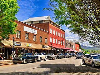
Franklin is a town in and the county seat of Macon County, North Carolina, United States. It is situated within the Nantahala National Forest. The population was reported to be 4,175 in the 2020 census, an increase from the total of 3,845 tabulated in 2010.

<span class="mw-page-title-main">Bryson City, North Carolina</span> Town in North Carolina, United States

Bryson City is a town in and the county seat of Swain County, North Carolina, United States. The population was 1,558 as of the 2020 census. Located in what was historically the land of the Cherokee, Bryson City was founded as Charleston to serve as the county seat of Swain County when it was formed from parts of surrounding counties. It grew into an important local rail hub. Today the city serves as a popular tourist destination, lying just to the west of the entrance to the Great Smoky Mountains National Park, for outdoor activities in the Nantahala National Forest, and along the Nantahala River and Fontana Lake, and serves as the home of the Great Smoky Mountains Railroad, a heritage railroad that provides tours of the Nantahala valley. The popular Nantahala Outdoor Center provides guide services for many of the outdoor activities in the area.

<span class="mw-page-title-main">Great Smoky Mountains National Park</span> National park in Tennessee and North Carolina

Great Smoky Mountains National Park is an American national park in the southeastern United States, with parts in North Carolina and Tennessee. The park straddles the ridgeline of the Great Smoky Mountains, part of the Blue Ridge Mountains, which are a division of the larger Appalachian Mountain chain. The park contains some of the highest mountains in eastern North America, including Clingmans Dome, Mount Guyot, and Mount Le Conte. The border between the two states runs northeast to southwest through the center of the park. The Appalachian Trail passes through the center of the park on its route from Georgia to Maine. With 13 million visitors in 2023, the Great Smoky Mountains National Park is the most visited national park in the United States.

<span class="mw-page-title-main">Cullasaja River</span> Stream in North Carolina, US

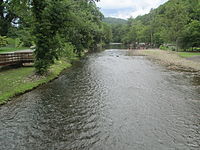
The Cullasaja River is a short river located entirely in Macon County, North Carolina. It is a tributary of the Little Tennessee River into which it flows near the county seat of Franklin.

<span class="mw-page-title-main">Great Smoky Mountains</span> American mountain range along North Carolina/Tennessee border

The Great Smoky Mountains are a mountain range rising along the Tennessee–North Carolina border in the southeastern United States. They are a subrange of the Appalachian Mountains and form part of the Blue Ridge Physiographic Province. The range is sometimes called the Smoky Mountains, and the name is commonly shortened to the Smokies. The Smokies are best known as the home of the Great Smoky Mountains National Park, which protects most of the range. The park was established in 1934 and, with over 11 million visits per year, is the most visited national park in the United States.

<span class="mw-page-title-main">Cherokee, North Carolina</span> Census-designated place in North Carolina, United States

Cherokee is a census-designated place (CDP) in Swain and Jackson counties in Western North Carolina, United States, within the Qualla Boundary land trust. Cherokee is located in the Oconaluftee River Valley around the intersection of U.S. Routes 19 and 441. As of the 2020 census, the CDP had a population of 2,195. It is the capital of the federally recognized Eastern Band of Cherokee Indians, one of three recognized Cherokee tribes and the only one in North Carolina.

<span class="mw-page-title-main">Qualla Boundary</span> Land held in trust for the Cherokee of North Carolina

The Qualla Boundary or The Qualla is territory held as a land trust by the United States government for the federally recognized Eastern Band of Cherokee Indians (EBCI), who reside in Western North Carolina. The area is part of the large historic Cherokee territory in the Southeast, which extended into eastern Tennessee, western South Carolina, northern Georgia and Alabama. Currently, the largest contiguous portion of the Qualla lies in Haywood, Swain, and Jackson counties and is centered on the community of Cherokee, which serves as the tribal capital of the Eastern Band of Cherokee Indians. Smaller, non-contiguous parcels also lie in Graham and Cherokee counties, near the communities of Snowbird and Murphy, respectively.

The Eastern Band of Cherokee Indians (EBCI), is a federally recognized Indian tribe based in western North Carolina in the United States. They are descended from the small group of 800–1,000 Cherokees who remained in the Eastern United States after the U.S. military, under the Indian Removal Act, moved the other 15,000 Cherokees to west of the Mississippi River in the late 1830s, to Indian Territory. Those Cherokees remaining in the east were to give up tribal Cherokee citizenship and to assimilate. They became U.S. citizens.

<span class="mw-page-title-main">Tuckasegee River</span> River in North Carolina, United States

The Tuckasegee River flows entirely within western North Carolina. It begins its course in Jackson County below Cullowhee at the confluence of Panthertown and Greenland creeks.

<span class="mw-page-title-main">Kituwa</span> Historic place in North Carolina, United States

Kituwa or giduwa (Cherokee:ᎩᏚᏩ) is an ancient Native American settlement near the upper Tuckasegee River, and is claimed by the Cherokee people as their original town. An earthwork platform mound, built about 1000 CE, marks a ceremonial site here. The historic Cherokee built a townhouse on top that was used for their communal gatherings and decisionmaking; they replaced it repeatedly over decades. They identify Kituwa as one of the "seven mother towns" in their traditional homeland of the American Southeast. This site is in modern Swain County, North Carolina, in the Great Smoky Mountains.

<span class="mw-page-title-main">Oconaluftee (Great Smoky Mountains)</span> River in North Carolina, USA

The Oconaluftee is the valley of the Oconaluftee River in the Great Smoky Mountains of North Carolina. Formerly the site of a Cherokee village and an Appalachian community, the valley is now North Carolina's main entrance to Great Smoky Mountains National Park.

<span class="mw-page-title-main">U.S. Route 19 in North Carolina</span> Segment of American highway

U.S. Highway 19 (US 19) traverses 145 miles (233 km) across Western North Carolina; from the Georgia state line, at the community of Bellview, to Cane River, where US 19 splits into US 19E and US 19W, which take separate routes into Tennessee.

<span class="mw-page-title-main">U.S. Route 441 in North Carolina</span> Highway in North Carolina

U.S. Route 441 (US 441) is a north–south United States Highway that runs from Miami, Florida to Rocky Top, Tennessee. In the U.S. state of North Carolina, US 441 travels for 64.5 miles (103.8 km) from the Georgia state line near Dillard, Georgia to the Tennessee state line in the Great Smoky Mountains National Park. US 441 is a primary route connecting the cities of Franklin, Sylva, and Cherokee in western North Carolina. The highway runs concurrently with other U.S. highways for much of its routing in North Carolina including US 23 from the Georgia state line to Dillsboro, US 64 in Franklin, US 74 from Dillsboro to near Qualla, and US 19 in Cherokee. US 441 has two business routes in North Carolina, in Franklin and Cherokee.

<span class="mw-page-title-main">Cherokee Preservation Foundation</span>

Cherokee Preservation Foundation is an independent nonprofit foundation established in 2000 as part of the Tribal-State Compact amendment between the Eastern Band of Cherokee Indians (EBCI) and the State of North Carolina. The Foundation is funded by the EBCI from gaming revenues generated by the Tribe; it is not associated with any for-profit gaming entity and is a separately functioning organization independent of the Tribal government. It works to improve the quality of life of the EBCI and strengthen the western North Carolina region by balancing Cherokee ways with the pursuit of new opportunities.

Ravensford is an unincorporated community in Swain County, Western North Carolina. This is within the traditional homeland of the Cherokee people. In a survey and excavation project in the early 21st century, part of the community was found to have archeological resources that were thousands of years old, in addition to more recent historic materials related to the Cherokee people. In 1938, the US Government and state of North Carolina negotiated with the Eastern Band of Cherokee Indians to gain their agreement to transfer some of their land to enable construction of the Blue Ridge Parkway. In return, lands in Ravensford were transferred to their Qualla Boundary property.

<span class="mw-page-title-main">Mingo Falls</span> Waterfall

Mingo Falls is a 120 ft (37 m) high waterfall located in the Qualla Boundary—a land trust of the Eastern Band of Cherokee Indians—near the town of Cherokee, Swain County, North Carolina in the Blue Ridge Mountains of the eastern United States. The waterfall is among the tallest in the southern Appalachians.

<span class="mw-page-title-main">Oconaluftee River</span> River in the eastern United States

The Oconaluftee River drains the south-central Oconaluftee valley of the Great Smoky Mountains in Western North Carolina before emptying into the Tuckasegee River. The river flows through the Qualla Boundary, a federal land trust that serves as a reserve for the Eastern Band of the Cherokee, the only federally recognized tribe in North Carolina. They bought the land back from the federal government in the 1870s, after having been pushed off and forced to cede it earlier in the 19th century. Several historic Cherokee towns are known to have been located along this river.

References

  1. 1 2 3 "QuickFacts: Swain County, North Carolina". United States Census Bureau. Retrieved March 22, 2024.
  2. "Find a County". National Association of Counties. Retrieved June 7, 2011.
  3. "Qualla Boundary | NCpedia".
  4. Cherokee Indians - Part 1: Overview | NCpediawww.ncpedia.org › cherokee › "These people and their descendants were recognized in 1868 by the federal government as the Eastern Band of Cherokee Indians. In the early 2000s these Cherokee, living on the Qualla Boundary in the western part of the state, were the only Indian tribe in North Carolina fully recognized by the federal government."
  5. "2020 County Gazetteer Files – North Carolina". United States Census Bureau. August 23, 2022. Retrieved September 9, 2023.
  6. Mount Mitchell State Park, North Carolina State Park System; www.ncparks.gov.
  7. "Travel Guide to Bryson City and the Great Smoky Mountains". Swain County NC Chamber of Commerce. Retrieved March 17, 2018.
  8. 1 2 3 "NCWRC Game Lands". www.ncpaws.org. Retrieved March 30, 2023.
  9. "U.S. Decennial Census". United States Census Bureau. Retrieved January 19, 2015.
  10. "Historical Census Browser". University of Virginia Library. Retrieved January 19, 2015.
  11. Forstall, Richard L., ed. (March 27, 1995). "Population of Counties by Decennial Census: 1900 to 1990". United States Census Bureau. Retrieved January 19, 2015.
  12. "Census 2000 PHC-T-4. Ranking Tables for Counties: 1990 and 2000" (PDF). United States Census Bureau. April 2, 2001. Archived (PDF) from the original on March 27, 2010. Retrieved January 19, 2015.
  13. "State & County QuickFacts". United States Census Bureau. Archived from the original on January 29, 2016. Retrieved October 30, 2013.
  14. "Explore Census Data". data.census.gov. Retrieved December 19, 2021.
  15. "U.S. Census website". United States Census Bureau . Retrieved January 31, 2008.
  16. Leip, David. "Dave Leip's Atlas of U.S. Presidential Elections". uselectionatlas.org. Retrieved March 17, 2018.
  17. "Qualla Boundary | NCpedia".
  18. "2020 CENSUS - SCHOOL DISTRICT REFERENCE MAP: Swain County, NC" (PDF). U.S. Census Bureau. Archived (PDF) from the original on July 18, 2021. Retrieved July 18, 2021.
  19. "Smoky Mountain Times". Smoky Mountain Times. July 8, 2023. Retrieved July 8, 2023.
  20. "Swain County Herald (Charleston, N.C.)". DigitalNC. Retrieved July 8, 2023.