Transylvania County, North Carolina

Last updated

Transylvania County
Brevard, North Carolina - Transylvania Co. Courthouse (cropped).JPG
Transylvania County Seal.png
Transylvania County Logo.png
Nickname: 
Land of Waterfalls
Map of North Carolina highlighting Transylvania County.svg
Location within the U.S. state of North Carolina
North Carolina in United States.svg
North Carolina's location within the U.S.
Coordinates: 35°13′N82°49′W / 35.21°N 82.82°W / 35.21; -82.82
CountryFlag of the United States.svg United States
StateFlag of North Carolina.svg  North Carolina
Founded1861
Named for Latin word meaning "Across the Woods" [1]
Seat Brevard
Largest communityBrevard
Area
  Total380.33 sq mi (985.1 km2)
  Land378.36 sq mi (979.9 km2)
  Water1.97 sq mi (5.1 km2)  0.52%
Population
 (2020)
  Total32,986
  Estimate 
(2023)
33,549
  Density87.18/sq mi (33.66/km2)
Time zone UTC−5 (Eastern)
  Summer (DST) UTC−4 (EDT)
Congressional district 11th
Website www.transylvaniacounty.org

Transylvania County is a county in the U.S. state of North Carolina. As of the 2020 census the population is 32,986. [2] Its county seat is Brevard. [3]

Contents

Transylvania County comprises the Brevard, NC Micropolitan Statistical Area, which is also included in the Asheville-Waynesville-Brevard, NC Combined Statistical Area.

History

The North Carolina General Assembly apportioned Transylvania County on February 15, 1861, from lands previously attributed to neighboring Jackson and Henderson counties; it was named by representative Joseph P. Jordan. [4] Until the early 20th century, the vast majority of Transylvania County residents subsisted through agriculture, growing staples such as potatoes and cabbage. [5]

Beginning in the early 20th century, with Joseph Silverstein's tannery in what was renamed as Rosman in 1905, a manufacturing economy began to develop in the county. It relied on timber and related products harvested from the Pisgah National Forest. In the 1930s, Harry Straus opened a paper mill in the Pisgah Forest area; by the mid-20th century, Straus's Ecusta Paper manufacturing site provided jobs to over 3,000 local residents. During the peak industrial years of the 1950s, DuPont had a factory in the county, employing nearly 1,000 more residents. [5]

In the following decades, Brevard College and its namesake town each grew at dramatic rates. The Brevard Music Center and its summer Brevard Music Festival began to attract musicians and enthusiasts from around the country to Transylvania County. [5]

Since the late 20th century, Transylvania County's economy has changed. Many of the manufacturing operations went defunct or moved offshore for cheap labor, including Ecusta and DuPont. Since then, the county has worked to reshape its economy around the growing summer and winter tourism industry in Appalachia. [5]

Geography

Transylvania County, North Carolina
Interactive map of Transylvania County
The Biltmore School of Forestry, founded in 1898, was the nation's first forestry school. Biltmore Forestry School, Schoolhouse, Brevard vicinity (Transylvania County, North Carolina).jpg
The Biltmore School of Forestry, founded in 1898, was the nation's first forestry school.

According to the U.S. Census Bureau, the county has an area of 380.33 square miles (985.1 km2), of which 378.36 square miles (979.9 km2) is land and 1.97 square miles (5.1 km2) (0.52%) water. [6]

Transylvania County contains the primary headwaters of the French Broad River, locally called North Fork, West Fork, East Fork, and Middle Fork. Since the county's northern and western boundaries follow mountain ridges, all these tributaries originate from sources in the county. The French Broad flows primarily east and northward through the county into Henderson County. [7]

The county's northern border follows the ridge line proximate to the Blue Ridge Parkway, and the southern border mostly follows the Eastern Continental Divide, from the border of Henderson County and South Carolina, westward to near US 178 and Jackson County. [8] The headwaters of Lake Toxaway lie south of the Eastern Continental Divide, becoming the Toxaway River, descending rapidly through Gorges State Park and into Lake Jocassee on the county's southern edge. This area, known as the Cane Brake, is difficult to access from North Carolina due to the steep slope of the trails in Gorges State Park, but can be reached more easily via the Foothills Trail from South Carolina. [9]

Transylvania County is known as the "Land of Waterfalls", due to it having over 250 waterfalls. This is due to a combination of its high precipitation and location on the Blue Ridge Escarpment. Notable waterfalls in the county include Looking Glass Falls, Moore Cove Falls, Rainbow Falls, and Whitewater Falls, the tallest waterfall east of the Mississippi. It receives over 90 inches (2,300 mm) of rain annually due to orographic lift, making it the state's wettest county. (Buncombe County, 30 miles (48 km) northeast, is the driest, as it sits in Transylvania County's rain shadow.) The Blue Ridge Parkway traverses parts of the county, and has views of the Appalachian Mountains, which reach over 6,000 feet (1,800 m) elevation in the county.

National protected areas

State and local protected areas

Major water bodies

Adjacent counties

Major highways

Demographics

Historical population
CensusPop.Note
1870 3,536
1880 5,34051.0%
1890 5,88110.1%
1900 6,62012.6%
1910 7,1918.6%
1920 9,30329.4%
1930 9,5893.1%
1940 12,24127.7%
1950 15,19424.1%
1960 16,3727.8%
1970 19,71320.4%
1980 23,41718.8%
1990 25,5209.0%
2000 29,33414.9%
2010 33,09012.8%
2020 32,986−0.3%
2023 (est.)33,549 [2] 1.7%
U.S. Decennial Census [11]
1790–1960 [12] 1900–1990 [13]
1990–2000 [14] 2010 [15] 2020 [2]

2020 census

Transylvania County racial composition [16]
RaceNumberPercentage
White (non-Hispanic)28,54286.53%
Black or African American (non-Hispanic)1,0273.11%
Native American 1020.31%
Asian 1730.52%
Pacific Islander 220.07%
Other/Mixed 1,4224.31%
Hispanic or Latino 1,6985.15%

As of the 2020 census, there were 32,986 people, 14,567 households, and 9,978 families residing in the county.

2010 census

At the 2010 census, [17] there were 33,090 people, 14,394 households, and 8,660 families residing in the county. The population density was 83 people per square mile (32 people/km2). There were 15,553 housing units at an average density of 41 units per square mile (16 units/km2). The racial makeup of the county was 92.4% White, 3.9% Black or African American, 0.3% Native American, 0.4% Asian, and 1.12% from two or more races. 2.9% of the population were Hispanic or Latino of any race.

There were 12,320 households, out of which 25.10% had children under the age of 18 living with them, 58.60% were married couples living together, 8.70% had a female householder with no husband present, and 29.70% were non-families. 26.10% of all households were made up of individuals, and 12.40% had someone living alone who was 65 years of age or older. The average household size was 2.30 and the average family size was 2.74.

In the county, the population was spread out, with 20.40% under the age of 18, 8.20% from 18 to 24, 23.10% from 25 to 44, 26.90% from 45 to 64, and 21.40% who were 65 years of age or older. The median age was 44 years. For every 100 females there were 92.70 males. For every 100 females age 18 and over, there were 89.50 males.

The median income for a household in the county was $38,587, and the median income for a family was $45,579. Males had a median income of $31,743 versus $21,191 for females. The per capita income for the county was $20,767. About 6.60% of families and 9.50% of the population were below the poverty line, including 11.80% of those under age 18 and 7.00% of those age 65 or over.

Government and politics

At present Transylvania is a solidly Republican county, although much less so than the vast majority of Appalachia. No Democratic presidential nominee has carried Transylvania County since Jimmy Carter did so in 1976.

United States presidential election results for Transylvania County, North Carolina [18]
Year Republican Democratic Third party
No.%No.%No.%
2020 11,63657.03%8,44441.38%3241.59%
2016 10,52058.87%6,55836.70%7914.43%
2012 9,63457.47%6,82640.72%3031.81%
2008 9,40155.60%7,27543.02%2331.38%
2004 9,38660.21%6,09739.11%1050.67%
2000 9,01163.35%5,04435.46%1701.20%
1996 6,73452.29%4,84237.60%1,30110.10%
1992 5,98445.55%5,12038.97%2,03315.48%
1988 7,00961.86%4,28037.78%410.36%
1984 6,95664.91%3,73334.83%280.26%
1980 4,82652.60%4,00843.68%3413.72%
1976 4,08946.51%4,63652.74%660.75%
1972 5,86069.73%2,32127.62%2232.65%
1968 4,03346.85%2,21025.67%2,36527.47%
1964 3,54744.17%4,48355.83%00.00%
1960 4,22155.47%3,38844.53%00.00%
1956 3,90153.18%3,43546.82%00.00%
1952 4,04752.64%3,64147.36%00.00%
1948 2,86146.42%2,97548.27%3275.31%
1944 2,25142.71%3,01957.29%00.00%
1940 2,01937.87%3,31262.13%00.00%
1936 2,00141.29%2,84558.71%00.00%
1932 1,67139.63%2,52359.84%220.52%
1928 2,16555.70%1,72244.30%00.00%
1924 1,81450.22%1,77649.17%220.61%
1920 1,68052.14%1,54247.86%00.00%
1916 84150.60%82149.40%00.00%
1912 1078.39%63149.45%53842.16%

Transylvania County has a council-manager form of government, with a five-member Board of Commissioners elected at large. The Commissioners hire and supervise a separate County Manager. The current County Manager is Jaime Laughter. The current members of the Board of Commissioners are Jason Chappell (chairman), Jake Dalton (vice-chairman), Teresa McCall, Larry Chapman, and Emmett Casciato.

Transylvania Regional Hospital (TRH) was formed in 1933 with the mission to serve the community's health care needs. A 94-bed facility fully accredited by the Joint Commission on Accreditation of Healthcare Organizations (JCAHO), it has more than 120 active, consulting and courtesy physicians representing a full spectrum of specialties.

Transylvania County is a member of the Land-of-Sky Regional Council of governments.

The current mayor of Brevard is Maureen Copelof. [19] The current mayor of Rosman is Brian Shelton. [20]

Points of interest

Looking Glass Falls Lookingglassfalls.jpg
Looking Glass Falls

Communities

Map of Transylvania County with municipal and township labels Map of Transylvania County North Carolina With Municipal and Township Labels.PNG
Map of Transylvania County with municipal and township labels

City

Town

Townships

  • Boyd
  • Brevard
  • Cathey's Creek
  • Dunn's Rock
  • Eastatoe
  • Gloucester
  • Hogback
  • Little River

Unincorporated communities

See also

Related Research Articles

<span class="mw-page-title-main">McDowell County, North Carolina</span> County in North Carolina, United States

McDowell County is a county located in the U.S. state of North Carolina. As of the 2020 census, the population was 44,578. Its county seat is Marion.

<span class="mw-page-title-main">Jackson County, North Carolina</span> County in North Carolina, United States

Jackson County is a county located in the western part of the U.S. state of North Carolina. As of the 2020 census, the population was 43,109. Since 1913, its county seat has been Sylva, which replaced Webster.

<span class="mw-page-title-main">Burke County, North Carolina</span> County in North Carolina, United States

Burke County is a county located in the U.S. state of North Carolina. As of the 2020 census, its population was 87,570. Its county seat is Morganton.

<span class="mw-page-title-main">Brevard, North Carolina</span> City in North Carolina, United States

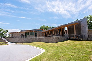
Brevard is a city and the county seat of Transylvania County, North Carolina, United States, with a population of 7,609 as of the 2010 census.

<span class="mw-page-title-main">Rosman, North Carolina</span> Town in North Carolina, United States

Rosman is a town in Transylvania County, North Carolina, United States. The population was 576 at the 2010 census. The northern terminus of U.S. Route 178 is less than one mile northwest of Rosman on U.S. Route 64.

<span class="mw-page-title-main">French Broad River</span> River in North Carolina and Tennessee, United States

The French Broad River is a river in the U.S. states of North Carolina and Tennessee. It flows 218 miles (351 km) from near the town of Rosman in Transylvania County, North Carolina, into Tennessee, where its confluence with the Holston River at Knoxville forms the beginning of the Tennessee River. The river flows through the counties of Transylvania, Buncombe, Henderson, and Madison in North Carolina, and Cocke, Jefferson, Sevier, and Knox in Tennessee. It drains large portions of the Pisgah National Forest and the Cherokee National Forest.

<span class="mw-page-title-main">Gorges State Park</span> State park in North Carolina, United States

Gorges State Park is a 7,709-acre (31.20 km2) North Carolina state park in Transylvania County, North Carolina in the United States and along with other conservation lands is part of a 100,000+ acre conservation corridor stretching some 80 miles along the NC/SC state line. The land, along Jocassee Gorges, was purchased by the state from Duke Energy Corporation in 1999. It is North Carolina's westernmost state park and one of the state's newest. The park is adjacent to part of the Pisgah National Forest and the N.C. Wildlife Resources Commission's Toxaway Game Land. Gorges State Park provides the principal access to the Horsepasture River on these adjoining public lands.

<span class="mw-page-title-main">U.S. Route 276</span> Highway in the United States

U.S. Route 276 is a United States highway that runs for 106.4 miles (171.2 km) from Mauldin, South Carolina to Cove Creek, North Carolina. It is known both as a busy urban highway in Greenville, South Carolina and a scenic back-road in Western North Carolina. Despite its numbering, it does not intersect its parent route U.S. Route 76.

<span class="mw-page-title-main">Lake Jocassee</span> Man-made lake in northwestern South Carolina, United States

Lake Jocassee is a 7,500-acre (30 km2), 300-foot (91 m) deep reservoir in northwest South Carolina. It was created in 1973 by the state in partnership with Duke Power. The lake is known for the clean and cold Appalachian mountain rivers that flow into it, keeping its waters cool and clear year-round. The Jocassee Dam, which forms the lake, is 385 feet (117 m) high and 1,750 feet (530 m) long. The lake is within Devils Fork State Park.

<span class="mw-page-title-main">Pisgah National Forest</span> National forest in North Carolina

Pisgah National Forest is a National Forest in the Appalachian Mountains of western North Carolina. It is administered by the United States Forest Service, part of the United States Department of Agriculture. The Pisgah National Forest is completely contained within the state of North Carolina. The forest is managed together with the other three North Carolina National Forests from common headquarters in Asheville, North Carolina. There are local ranger district offices located in Pisgah Forest, Mars Hill, and Nebo.

<span class="mw-page-title-main">DuPont State Forest</span> Protected area in North Carolina, United States

DuPont State Recreational Forest, commonly known as DuPont Forest, is a 12,500-acre (51 km2) state forest, located in Henderson and Transylvania counties of North Carolina. The name originates from the fact that the DuPont company arranged the sale of the original tract to the state. Adjacent tracts have since been purchased and added to the state forest. Portions of the forest formerly contained a manufacturing facility for the production of X-ray film. The forest was used to shoot scenes from the 1992 film The Last of the Mohicans as well as the 2012 box office hit The Hunger Games. On February 12, 2019, the forest added 402 acres (1.63 km2) from Conserving Carolina, part of a section called the Continental Divide Tract that connects with other public lands. 314 more acres was added to the forest in 2019.

<span class="mw-page-title-main">North Carolina Highway 215</span> State highway in North Carolina, US

North Carolina Highway 215 (NC 215) is a highway in western North Carolina that runs from the town of Rosman in Transylvania County to Canton at Interstate 40 and U.S. Route 74 (US 74). The portion from Canton to Rosman is a part of the US Forest Service's Forest Heritage Scenic Byway. It travels high into the mountains along a scenic stretch of the upper West Fork of the Pigeon River, and intersects the Blue Ridge Parkway at Beech Gap at an elevation of approximately 5,300 feet (1,600 m).

The Toxaway River is a 21.4-mile-long (34.4 km) waterway that flows south from headwaters in Transylvania County, North Carolina, into Lake Toxaway and over Toxaway Falls, after which it crosses into South Carolina and enters Lake Jocassee, the reservoir behind Lake Jocassee Dam.

The Horsepasture River is an 18.1-mile-long (29.1 km) National Wild and Scenic river in the U.S. states of North Carolina and South Carolina. The river rises in Jackson County, North Carolina, and flows through the Jocassee Gorges area and ends at Lake Jocassee in South Carolina. Some of the land over which the river flows is part of the Pisgah National Forest, making it accessible to the public.

<span class="mw-page-title-main">Foothills Trail</span> Long-distance hiking trail in the United States

The Foothills Trail is a 76-mile (122 km) National Recreation Trail in South and North Carolina, United States, for recreational hiking and backpacking. It extends from Table Rock State Park to Oconee State Park. It passes through the Andrew Pickens Ranger District of the Sumter National Forest, Ellicott Rock Wilderness, Whitewater Falls, and Lake Jocassee.

<span class="mw-page-title-main">Moore Cove Falls</span> Waterfall in Transylvania County, North Carolina

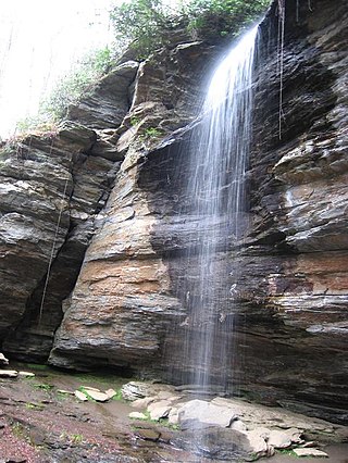
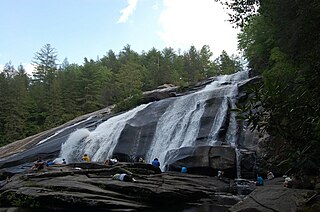
Moore Cove Falls is a waterfall in Pisgah National Forest in Western North Carolina, located near Brevard.

<span class="mw-page-title-main">Asheville metropolitan area</span> Metropolitan area in North Carolina, United States

The Asheville metropolitan area is a metropolitan area centered on the principal city of Asheville, North Carolina. The U.S. Office of Management and Budget defines the Asheville, NC Metropolitan Statistical Area, a metropolitan statistical area used by the United States Census Bureau and other entities, as comprising the four counties of Buncombe, Haywood, Henderson, and Madison. The area's population was 424,858 according to the 2010 census, and 469,454 according to the 2020 census.

The Transylvania Times is an American, English language bi-weekly newspaper in Transylvania County, North Carolina, in the United States, and its surrounding area. The paper was founded in 1887, and was family-owned and operated until it was sold to Community Newspaper Holdings in 2021. It provides news coverage for Brevard, Pisgah Forest, Rosman and Lake Toxaway, as well as the townships of Cathey's Creek, Dunn's Rock, Eastatoe, Gloucester, Hogback and Little River.

<span class="mw-page-title-main">Forest Heritage Scenic Byway</span>

The Forest Heritage Scenic Byway is a 76.7-mile (123.4 km) National Forest Scenic Byway, National Scenic Byway and North Carolina Scenic Byway that traverses through the Pisgah National Forest, in Western North Carolina. It features the Cradle of Forestry, waterfalls, trails and scenic vistas.

Headwaters State Forest is a 6,730-acre (27.2 km2) state forest, located in Transylvania County, North Carolina, along the South Carolina state line and is part of a larger 100,000+ acre conservation corridor that stretches some 80 miles along the state line. The name originates from the fact that the forest contains the headwaters of East Fork of the French Broad River. The North Carolina Forest Service primarily manages the forest for water and soil quality, as well as protecting rare species; however, primitive recreational uses are permitted.

References

  1. Lewis, J.D. "Transylvania County, North Carolina". www.carolana.com. Retrieved September 9, 2023.
  2. 1 2 3 "QuickFacts: Transylvania County, North Carolina". United States Census Bureau. Retrieved March 22, 2024.
  3. "Find a County". National Association of Counties. Retrieved June 7, 2011.
  4. Threlkel, du Toit; Brian, Susan. "1861-1911 Timeline". Transylvania Heritage Museum. Retrieved October 30, 2019.
  5. 1 2 3 4 Archived at Ghostarchive and the Wayback Machine : mktconnections (2011). "Transylvania County Sesquicentennial Video". YouTube .
  6. "2020 County Gazetteer Files – North Carolina". United States Census Bureau. August 23, 2022. Retrieved September 9, 2023.
  7. "Feature Detail Report for: French Broad River". US Geological Survey. Retrieved October 31, 2019.
  8. Watson, Melissa (2011). Hiking Waterfalls in North Carolina: A Guide to the State's Best Waterfall Hikes. FalconGuides. pp. 80–84. ISBN   978-0762771509.
  9. Thomas, Bill (1998). The North Carolina Sierra Club's guide to the Jocassee Gorges: Horsepasture, Bearwallow, & Toxaway Region. pp. 5–8.
  10. 1 2 3 4 "NCWRC Game Lands". www.ncpaws.org. Retrieved March 30, 2023.
  11. "U.S. Decennial Census". United States Census Bureau. Retrieved January 20, 2015.
  12. "Historical Census Browser". University of Virginia Library. Retrieved January 20, 2015.
  13. Forstall, Richard L., ed. (March 27, 1995). "Population of Counties by Decennial Census: 1900 to 1990". United States Census Bureau. Retrieved January 20, 2015.
  14. "Census 2000 PHC-T-4. Ranking Tables for Counties: 1990 and 2000" (PDF). United States Census Bureau. April 2, 2001. Archived (PDF) from the original on March 27, 2010. Retrieved January 20, 2015.
  15. "Decennial Census: P2: Hispanic or Latino, and not Hispanic or Latino by Race". US Census Bureau. Retrieved January 9, 2022.
  16. "Explore Census Data". data.census.gov. Retrieved December 19, 2021.
  17. "U.S. Census website". United States Census Bureau . Retrieved January 31, 2008.
  18. Leip, David. "Dave Leip's Atlas of U.S. Presidential Elections". uselectionatlas.org. Retrieved March 17, 2018.
  19. "Mayor & City Council". www.cityofbrevard.com. Retrieved July 20, 2023.
  20. "About". Town of Rosman. Retrieved July 20, 2023.
  21. 1 2 3 "About Our County | Transylvania County". www.transylvaniacounty.org. Retrieved March 17, 2018.
  22. "» Outdoor adventure and recreation in Brevard WNC, Transylvania County the Land of waterfalls Visit Brevard NC". brevardnc.com. Retrieved March 17, 2018.
  23. "Transylvania County Schools / Homepage". www.tcsnc.org. Retrieved March 17, 2018.