Washington County | |
---|---|
Nickname: Bear-Olina | |
Motto(s): "Where traffic ends and adventure begins." | |
Coordinates: 35°50′N76°34′W / 35.84°N 76.57°W | |
Country | United States |
State | North Carolina |
Founded | 1799 |
Named for | George Washington |
Seat | Plymouth |
Largest community | Plymouth |
Area | |
• Total | 421.91 sq mi (1,092.7 km2) |
• Land | 346.51 sq mi (897.5 km2) |
• Water | 75.40 sq mi (195.3 km2) 17.87% |
Population (2020) | |
• Total | 11,003 |
• Estimate (2023) | 10,713 |
• Density | 31.75/sq mi (12.26/km2) |
Time zone | UTC−5 (Eastern) |
• Summer (DST) | UTC−4 (EDT) |
Congressional district | 1st |
Website | www |
Washington County is a county located in the U.S. state of North Carolina. As of the 2020 census, the population was 11,003. [1] Its county seat is Plymouth. [2] The county was formed in 1799 from the western third of Tyrrell County. It was named for George Washington.
There are three incorporated towns in Washington County; Plymouth is the county seat, while other towns are Roper and Creswell. Washington County is known for rich farmland, extensive forests and abundant public access waters. [3] The Roanoke River and Albemarle Sound form the northern boundary. Lake Phelps is 16,000 acres and is part of Pettigrew State Park in Creswell. Somerset Place is a restored antebellum plantation and NC Historic Site on Lake Phelps. [4]
The Pungo Unit of the Pocosin Lakes National Wildlife Refuge in the southern part of the county is said to have the best public black bear viewing in North Carolina. This part of the state is known for having the world's largest black bears and highest black bear densities [5] The award-winning NC Black Bear Festival takes place in Plymouth on the first weekend in June.
According to the U.S. Census Bureau, the county has a total area of 421.91 square miles (1,092.7 km2), of which 346.51 square miles (897.5 km2) is land and 75.40 square miles (195.3 km2) (17.87%) is water. [6] The county borders the Albemarle Sound.
Census | Pop. | Note | %± |
---|---|---|---|
1800 | 2,422 | — | |
1810 | 3,464 | 43.0% | |
1820 | 3,986 | 15.1% | |
1830 | 4,552 | 14.2% | |
1840 | 4,525 | −0.6% | |
1850 | 5,664 | 25.2% | |
1860 | 6,357 | 12.2% | |
1870 | 6,516 | 2.5% | |
1880 | 8,928 | 37.0% | |
1890 | 10,200 | 14.2% | |
1900 | 10,608 | 4.0% | |
1910 | 11,062 | 4.3% | |
1920 | 11,429 | 3.3% | |
1930 | 11,603 | 1.5% | |
1940 | 12,323 | 6.2% | |
1950 | 13,180 | 7.0% | |
1960 | 13,488 | 2.3% | |
1970 | 14,038 | 4.1% | |
1980 | 14,801 | 5.4% | |
1990 | 13,997 | −5.4% | |
2000 | 13,723 | −2.0% | |
2010 | 13,228 | −3.6% | |
2020 | 11,003 | −16.8% | |
2023 (est.) | 10,713 | [1] | −2.6% |
U.S. Decennial Census [8] 1790–1960 [9] 1900–1990 [10] 1990–2000 [11] 2010 [12] 2020 [1] |
Race / Ethnicity (NH = Non-Hispanic) | Pop 2010 [13] | Pop 2020 [14] | % 2010 | % 2020 |
---|---|---|---|---|
White alone (NH) | 5,998 | 4,958 | 45.34% | 45.06% |
Black or African American alone (NH) | 6,567 | 5,350 | 49.64% | 48.62% |
Native American or Alaska Native alone (NH) | 21 | 15 | 0.16% | 0.14% |
Asian alone (NH) | 38 | 37 | 0.29% | 0.34% |
Pacific Islander alone (NH) | 1 | 3 | 0.01% | 0.03% |
Some Other Race alone (NH) | 14 | 36 | 0.11% | 0.33% |
Mixed Race/Multi-Racial (NH) | 123 | 233 | 0.93% | 2.12% |
Hispanic or Latino (any race) | 466 | 371 | 3.52% | 3.37% |
Total | 13,228 | 11,003 | 100.00% | 100.00% |
Race | Pop 2010 [15] | Pop 2020 [16] | % 2010 | % 2020 |
---|---|---|---|---|
White alone (NH) | 6,084 | 4,999 | 45.99% | 45.43% |
Black or African American alone (NH) | 6,587 | 5,375 | 49.80% | 48.85% |
Native American or Alaska Native alone (NH) | 24 | 23 | 0.18% | 0.21% |
Asian alone (NH) | 38 | 37 | 0.29% | 0.34% |
Pacific Islander alone (NH) | 1 | 9 | 0.01% | 0.08% |
Some Other Race alone (NH) | 340 | 223 | 2.57% | 2.03% |
Mixed Race/Multi-Racial (NH) | 154 | 337 | 1.16% | 3.06% |
Total | 13,228 | 11,003 | 100.00% | 100.00% |
As of the 2020 census, there were 11,003 people, 4,977 households, and 2,655 families residing in the county.
At the 2000 census, [17] there were 13,723 people, 5,367 households, and 3,907 families residing in the county. The population density was 39 people per square mile (15 people/km2). There were 6,174 housing units at an average density of 18 units per square mile (6.9 units/km2). The racial makeup of the county was 48.28% White, 48.94% Black or African American, 0.05% Native American, 0.32% Asian, 0.04% Pacific Islander, 1.66% from other races, and 0.70% from two or more races. 2.27% of the population were Hispanic or Latino of any race.
There were 5,367 households, out of which 31.70% had children under the age of 18 living with them, 50.10% were married couples living together, 18.80% had a female householder with no husband present, and 27.20% were non-families. 24.70% of all households were made up of individuals, and 11.70% had someone living alone who was 65 years of age or older. The average household size was 2.52 and the average family size was 2.99.
In the county, the population was spread out, with 26.00% under the age of 18, 7.70% from 18 to 24, 25.00% from 25 to 44, 25.80% from 45 to 64, and 15.50% who were 65 years of age or older. The median age was 39 years. For every 100 females there were 89.70 males. For every 100 females age 18 and over, there were 86.10 males.
The median income for a household in the county was $28,865, and the median income for a family was $34,888. Males had a median income of $27,058 versus $19,477 for females. The per capita income for the county was $14,994. About 17.60% of families and 21.80% of the population were below the poverty line, including 31.50% of those under age 18 and 19.20% of those age 65 or over.
Washington County is a member of the Albemarle Commission regional council of governments.
Washington County was one of the proposed sites for a Navy outlying landing field. This practice airfield would allow pilots to simulate landings on an aircraft carrier. Plans for construction have been scrapped due to public backlash and potential ecological impact. [18]
Year | Republican | Democratic | Third party | |||
---|---|---|---|---|---|---|
No. | % | No. | % | No. | % | |
2020 | 2,781 | 44.82% | 3,396 | 54.73% | 28 | 0.45% |
2016 | 2,564 | 41.59% | 3,510 | 56.93% | 91 | 1.48% |
2012 | 2,622 | 40.34% | 3,833 | 58.98% | 44 | 0.68% |
2008 | 2,670 | 41.37% | 3,748 | 58.07% | 36 | 0.56% |
2004 | 2,484 | 45.40% | 2,969 | 54.27% | 18 | 0.33% |
2000 | 2,169 | 44.36% | 2,704 | 55.30% | 17 | 0.35% |
1996 | 1,562 | 34.47% | 2,790 | 61.56% | 180 | 3.97% |
1992 | 1,780 | 33.89% | 2,902 | 55.24% | 571 | 10.87% |
1988 | 2,186 | 43.69% | 2,806 | 56.08% | 12 | 0.24% |
1984 | 2,731 | 46.67% | 3,114 | 53.21% | 7 | 0.12% |
1980 | 1,943 | 38.57% | 3,008 | 59.72% | 86 | 1.71% |
1976 | 1,486 | 34.07% | 2,840 | 65.12% | 35 | 0.80% |
1972 | 2,559 | 61.65% | 1,546 | 37.24% | 46 | 1.11% |
1968 | 1,016 | 21.26% | 1,898 | 39.71% | 1,866 | 39.04% |
1964 | 1,144 | 31.35% | 2,505 | 68.65% | 0 | 0.00% |
1960 | 1,027 | 29.84% | 2,415 | 70.16% | 0 | 0.00% |
1956 | 1,033 | 34.66% | 1,947 | 65.34% | 0 | 0.00% |
1952 | 774 | 28.17% | 1,974 | 71.83% | 0 | 0.00% |
1948 | 333 | 16.19% | 1,675 | 81.43% | 49 | 2.38% |
1944 | 497 | 21.81% | 1,782 | 78.19% | 0 | 0.00% |
1940 | 362 | 17.35% | 1,724 | 82.65% | 0 | 0.00% |
1936 | 535 | 22.20% | 1,875 | 77.80% | 0 | 0.00% |
1932 | 619 | 26.77% | 1,681 | 72.71% | 12 | 0.52% |
1928 | 1,183 | 56.85% | 898 | 43.15% | 0 | 0.00% |
1924 | 834 | 48.40% | 883 | 51.25% | 6 | 0.35% |
1920 | 971 | 46.53% | 1,116 | 53.47% | 0 | 0.00% |
1916 | 486 | 42.74% | 651 | 57.26% | 0 | 0.00% |
1912 | 384 | 37.07% | 503 | 48.55% | 149 | 14.38% |
Washington County School District contains all public schools. The district contains a high school, a five-year early college, a middle school, and two elementary schools. [20]
Pocosin Innovative Charter School is a charter school separate from the district. [21]
Cooke County is a county in the U.S. state of Texas. At the 2020 census, its population was 41,668. The county seat is Gainesville. The county was founded in 1848 and organized the next year. It is named for William Gordon Cooke, a soldier during the Texas Revolution. It is a part of the Texoma region.
Warren County is a county located in the northeastern Piedmont region of the U.S. state of North Carolina, on the northern border with Virginia, made famous for a landfill and birthplace of the environmental justice movement. As of the 2020 census, its population was 18,642. Its county seat is Warrenton. It was a center of tobacco and cotton plantations, education, and later textile mills.
Vance County is a county located in the U.S. state of North Carolina. As of the 2020 census, the population was 42,578. Its county seat is Henderson.
Tyrrell County is a county located in the U.S. state of North Carolina. As of the 2020 census, the population was 3,245, making it the least populous county in North Carolina. Its county seat is Columbia. The county was created in 1729 as Tyrrell Precinct and gained county status in 1739.
Stanly County is a county in the U.S. state of North Carolina. As of the 2020 census, the population was 62,504. Its county seat is Albemarle.
Perquimans County is a county located in the U.S. state of North Carolina. As of the 2020 census, the population was 13,005. Its county seat is Hertford. The Harvey Point Defense Testing Activity facility is located in Perquimans County.
Northampton County is a county located in the U.S. state of North Carolina. As of the 2020 census, the population was 17,471. Its county seat is Jackson.
Hyde County is a county located in the U.S. state of North Carolina. As of the 2020 census, the population was 4,589, making it the second-least populous county in North Carolina. Its county seat is Swan Quarter. The county was created in 1705 as Wickham Precinct. It was renamed Hyde Precinct in 1712 and gained county status in 1739.
Edgecombe County is a county located in the U.S. state of North Carolina. As of the 2020 census, the population was 48,900. Its county seat is Tarboro.
Dare County is the easternmost county in the U.S. state of North Carolina. As of the 2020 census, the population was 36,915. Its county seat is Manteo.
Chowan County is one of the 100 counties located in the U.S. state of North Carolina. As of the 2020 census, the population was 13,708. Its county seat is Edenton. The county was created between 1668 and 1671 as Shaftesbury Precinct and later renamed Chowan Precinct. It gained county status in 1739.
Carteret County is a county located in the U.S. state of North Carolina. As of the 2020 census, the population was 67,686. Its county seat is Beaufort. The county was created in 1722 as Carteret Precinct and gained county status in 1739. It was named for Sir George Carteret, one of the 17th century English Lords Proprietor, or for his descendant and heir John Carteret, 2nd Earl Granville.
Bertie County is a county located in the northeast area of the U.S. state of North Carolina. As of the 2020 census, the population was 17,934. Its county seat is Windsor. The county was created in 1722 as Bertie Precinct and gained county status in 1739.
Cashiers is a census-designated place (CDP) and unincorporated village located in southern Jackson County, North Carolina, United States. As of the 2020 United States census, the community had a total population of 657, up from 157 at the 2010 census. Cashiers is pronounced KASH-erz locally, and is one of several communities in the area popular with tourists and owners of vacation homes.
Oak City, formerly known as Goose Nest, is a town in Martin County, North Carolina, United States. The population was 266 at the 2020 census.
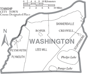
Creswell is a town in Washington County, North Carolina, United States. The population was 207 at the 2020 census.
Plymouth is the most populous town in Washington County, North Carolina, United States. The population was 3,320 at the 2020 census. It is the county seat of Washington County. Plymouth is located on the Roanoke River about seven miles (11 km) upriver from its mouth into the Albemarle Sound in North Carolina's Inner Banks region.
Brogden is a census-designated place (CDP) in Wayne County, North Carolina, United States. The population was 2,510 in 2020. It is included in the Goldsboro, North Carolina Metropolitan Statistical Area.
The Scuppernong River is a blackwater river that flows through Tyrrell County and Washington County, North Carolina, into the Albemarle Sound. The river shares its name with the Scuppernong grapes native to the area. The river has a history closely linked to colonization and agricultural utilization. Currently, the Pocosin Lakes National Wildlife Refuge and Pettigrew State Park can be found on the banks of the river. The River is celebrated annually through the Scuppernong River Festival.
The Pocosin Lakes National Wildlife Refuge is located in North Carolina's Inner Banks on the Albemarle-Pamlico Peninsula in Hyde, Tyrrell, and Washington Counties, North Carolina. Its headquarters is located in Columbia.