New Hanover County, North Carolina

Last updated

New Hanover County
New Hanover County Courthouse (March 2023) 17.jpg
New Hanover County Flag.gif
New Hanover County Seal.png
Motto: 
"The model of good governance"
Map of North Carolina highlighting New Hanover County.svg
Location within the U.S. state of North Carolina
North Carolina in United States.svg
North Carolina's location within the U.S.
Coordinates: 34°11′N77°52′W / 34.18°N 77.86°W / 34.18; -77.86
CountryFlag of the United States.svg United States
StateFlag of North Carolina.svg  North Carolina
Founded1729
Named for House of Hanover
Seat Wilmington
Largest communityWilmington
Area
  Total328.86 sq mi (851.7 km2)
  Land192.26 sq mi (498.0 km2)
  Water136.60 sq mi (353.8 km2)  41.54%
Population
 (2020)
  Total225,702
  Estimate 
(2023)
238,852
  Density1,173.94/sq mi (453.26/km2)
Time zone UTC−5 (Eastern)
  Summer (DST) UTC−4 (EDT)
Congressional district 7th
Website www.nhcgov.com

New Hanover County is a county located in the U.S. state of North Carolina. As of the 2020 census, the population was 225,702. [1] Though the second-smallest county in North Carolina by land area, [2] it is one of the most populous, as its county seat, Wilmington, [3] is one of the state's largest communities. The county was created in 1729 as New Hanover Precinct and gained county status in 1739. [4] New Hanover County is included in the Wilmington, NC Metropolitan Statistical Area, which also includes neighboring Pender and Brunswick counties.

Contents

History

Located in the Low Country or Tidewater of North Carolina, the county was formed in 1729 as New Hanover Precinct of Bath County, from Craven Precinct. It was named for the House of Hanover, a German royal family then ruling Great Britain. [5]

In 1734 parts of New Hanover Precinct became Bladen Precinct and Onslow Precinct. With the abolition of Bath County in 1739, all of its constituent precincts became counties.

In 1750 the northern part of New Hanover County became Duplin County. In 1764 another part of New Hanover County was combined with part of Bladen County to form Brunswick County. Finally, in 1875 the separation of northern New Hanover County to form Pender County reduced it to its present dimensions. The county was developed as plantations, largely for the cultivation of tobacco and other commodity crops by enslaved African Americans. [6]

By 1860, the county seat and county were majority-black in population, with most of those people enslaved. Some of the closing battles of the American Civil War took place in this county, including the Second Battle of Fort Fisher (the last major coastal stronghold of the Confederacy) and the Battle of Wilmington. White Democrats were resentful when freedmen were given the vote.

Following the Reconstruction era, white Democrats regained control of the state legislature and continued to impose white supremacy across the state through Jim Crow laws. Violence by whites against blacks increased in the late 19th century, with 22 lynching deaths of African Americans recorded before the mid-20th century. [7] [8]

Racial terrorism on a larger scale took place in the Wilmington Insurrection of 1898, when a group of white Democrats rejected a duly elected, biracial city government. After overthrowing the Fusionist government, the mayor and city council, they led mobs that rioted and attacked the city's black neighborhoods and residents. A total of 60 to 300 blacks are believed to have been killed in the rioting, leaders were driven out of the city, and the presses of a black-owned newspaper were destroyed, along with many houses and businesses. [9] [10]

The insurrection was planned by a group of nine conspirators, who included Hugh MacRae. He later donated land to New Hanover County for a park; it was named in his honor. A plaque was installed there explaining the donation and his life; it does not refer to his role in the 1898 coup d'état. [11] However, in July 2020, the name of the park was changed from "Hugh McRae Park" to "Long Leaf Park" due to his role in the insurrection. [12]

Soon after, the state passed a new constitution raising barriers to voter registration: this effectively disenfranchised most blacks and imposed Jim Crow laws, forcing blacks out of the political system and into legal second-class status. These civil rights injustices were largely maintained into the 1960s, three generations later. [13]

Geography

New Hanover County, North Carolina
Interactive map of New Hanover County
Intersection of South College Road, South 17th Street, and Waltmoor Road from the air NC 132 from the Air in New Hanover County 9.jpg
Intersection of South College Road, South 17th Street, and Waltmoor Road from the air
The surf at Carolina Beach Carolina Beach in New Hanover County, NC IMG 4435.JPG
The surf at Carolina Beach

According to the U.S. Census Bureau, the county has a total area of 328.86 square miles (851.7 km2), of which 192.26 square miles (498.0 km2) is land and 136.60 square miles (353.8 km2) (41.54%) is water. [14] It is the second-smallest county in North Carolina by land area (ahead of only Chowan County).

State and local protected areas/sites

Major water bodies

Major islands

Adjacent counties

Major highways

Major infrastructure

Demographics

Historical population
CensusPop.Note
1790 6,837
1800 7,0603.3%
1810 11,46562.4%
1820 10,866−5.2%
1830 10,9590.9%
1840 13,31221.5%
1850 17,66832.7%
1860 21,71522.9%
1870 27,97828.8%
1880 21,376−23.6%
1890 24,02612.4%
1900 25,7857.3%
1910 32,03724.2%
1920 40,62026.8%
1930 43,0105.9%
1940 47,93511.5%
1950 63,27232.0%
1960 71,74213.4%
1970 82,99615.7%
1980 103,47124.7%
1990 120,28416.2%
2000 160,30733.3%
2010 202,66726.4%
2020 225,70211.4%
2023 (est.)238,852 [1] 5.8%
U.S. Decennial Census [21]
1790–1960 [22] 1900–1990 [23]
1990–2000 [24] 2010 [25] 2020 [1]

2020 census

New Hanover County racial composition [26]
RaceNumberPercentage
White (non-Hispanic)167,15074.06%
Black or African American (non-Hispanic)26,97411.95%
Native American 6780.3%
Asian 3,4681.54%
Pacific Islander 1480.07%
Other/Mixed 9,9844.42%
Hispanic or Latino 17,3007.66%

As of the 2020 census, there were 225,702 people, 100,189 households, and 56,160 families residing in the county.

2000 census

At the 2000 census, [27] there were 160,307 people, 68,183 households, and 41,591 families residing in the county. The population density was 806 people per square mile (311 people/km2). There were 79,616 housing units at an average density of 400 units per square mile (150 units/km2). The racial makeup of the county was 79.91% White, 16.97% Black or African American, 0.39% Native American, 0.83% Asian, 0.06% Pacific Islander, 0.79% from other races, and 1.05% from two or more races. 2.04% of the population were Hispanic or Latino of any race. 14.3% were of English, 13.0% United States or American, 10.6% German and 10.2% Irish ancestry according to Census 2000.

There were 68,183 households, out of which 26.10% had children under the age of 18 living with them, 46.50% were married couples living together, 11.50% had a female householder with no husband present, and 39.00% were non-families. 28.90% of all households were made up of individuals, and 8.50% had someone living alone who was 65 years of age or older. The average household size were 2.29 and the average family size was 2.83.

In the county, the population was spread out, with 21.00% under the age of 18, 12.00% from 18 to 24, 30.50% from 25 to 44, 23.70% from 45 to 64, and 12.80% who were 65 years of age or older. The median age was 36 years. For every 100 females there were 93.30 males. For every 100 females age 18 and over, there were 90.70 males.

The median income for a household in the county was $40,172, and the median income for a family was $50,861. Males had a median income of $35,801 versus $25,305 for females. The per capita income for the county was $23,123. About 8.30% of families and 13.10% of the population were below the poverty line, including 15.70% of those under age 18 and 9.00% of those age 65 or over.

Law and government

W. Allen Cobb Judicial Annex in Wilmington New Hanover County Courthouse (March 2023) 9 (cropped).jpg
W. Allen Cobb Judicial Annex in Wilmington
New Hanover County Jail and Sheriff's Office in unincorporated Castle Hayne New Hanover County Sheriff's Complex.jpg
New Hanover County Jail and Sheriff's Office in unincorporated Castle Hayne

New Hanover County is governed by a county commission. The commission comprises five members elected at-large in four-year staggered terms. The body elects its own chairman and vice-chairman. It sets policy for county administration within the confines of state law, adopts local ordinances, appoints advisory committees, and enacts an annual county budget. [28]

New Hanover County is represented in the U.S. House of Representatives by Republican David Rouzer, who is the representative for North Carolina's 7th congressional district. [29] From 2013 to 2017, a portion of northwestern and central New Hanover County was redistricted to North Carolina's 3rd congressional district, which was represented by Republican Walter B. Jones Jr. before his death. The county is also in the 7th and 8th districts of the North Carolina Senate, represented by Republicans Michael V. Lee and Bill Rabon, respectively; and the 18th, 19th, and 20th districts of the North Carolina House of Representatives, represented by two Republicans and one Democrat. [30]

New Hanover County is a member of the regional Cape Fear Council of Governments.

New Hanover County Sheriff's Office (NHCSO) serves as the county's primary law enforcement agency. NHCSO is responsible for patrolling the county (primarily outside the Wilmington city limits), staffing the juvenile and adult correctional facilities, and proving court security for the W. Allen Cobb Judicial Annex in Wilmington.

Politics

New Hanover County is politically competitive. [31] [32] It favored Republican presidential candidates every election between 1968 and 2016, except in 1976, with county favoring Democrat Joe Biden in 2020. The county has also favored Democratic U.S. Senate candidates in recent elections, though Republicans still tend to perform better in local contests. [31]

United States presidential election results for New Hanover County, North Carolina [33]
Year Republican Democratic Third party
No.%No.%No.%
2020 63,33148.04%66,13850.17%2,3611.79%
2016 55,34449.46%50,97945.56%5,5824.99%
2012 53,38551.52%48,66846.96%1,5751.52%
2008 50,54450.21%49,14548.82%9760.97%
2004 45,35155.82%35,57243.78%3240.40%
2000 36,50355.04%29,29244.17%5240.79%
1996 27,88950.92%22,83941.70%4,0417.38%
1992 24,33846.67%20,29138.91%7,52514.43%
1988 23,80760.56%15,40139.18%1050.27%
1984 23,77165.21%12,59134.54%900.25%
1980 17,24353.48%13,67042.40%1,3314.13%
1976 13,68748.06%14,50450.93%2861.00%
1972 19,06074.41%5,89423.01%6612.58%
1968 10,02037.03%7,75028.64%9,29134.33%
1964 12,14049.10%12,58450.90%00.00%
1960 9,77542.58%13,18257.42%00.00%
1956 9,47048.03%10,24751.97%00.00%
1952 9,33047.46%10,33052.54%00.00%
1948 3,16228.25%5,36447.92%2,66723.83%
1944 2,82923.01%9,46776.99%00.00%
1940 1,63515.97%8,60084.03%00.00%
1936 1,30615.04%7,37984.96%00.00%
1932 1,43018.81%6,03079.33%1411.86%
1928 4,24860.62%2,76039.38%00.00%
1924 1,19018.80%4,73574.80%4056.40%
1920 71214.79%4,10285.21%00.00%
1916 49217.28%2,35582.72%00.00%
1912 1406.17%2,02189.11%1074.72%
1908 51121.58%1,85778.42%00.00%
1904 916.77%1,25493.23%00.00%
1900 602.60%2,24797.40%00.00%
1896 3,18358.17%2,10038.38%1893.45%
1892 1,50038.01%2,40861.02%380.96%
1888 2,85660.43%1,87039.57%00.00%
1884 2,89462.38%1,74537.62%00.00%
1880 2,20055.88%1,43836.53%2997.59%

Education

The county is served by New Hanover County Schools.

Healthcare

New Hanover Regional Medical Center is a hospital in Wilmington. It was established in 1967 as a public hospital, and it was the first hospital in the city to admit patients of all races. [34] It was operated by New Hanover County. [35] In February 2021 Novant Health, a nonprofit private organization, acquired the hospital. [36]

Communities

Map of New Hanover County with municipal and township labels Map of New Hanover County North Carolina With Municipal and Township Labels.PNG
Map of New Hanover County with municipal and township labels

City

Towns

Townships

Census-designated places

Unincorporated community

Former communities

Notable people

See also

Related Research Articles

<span class="mw-page-title-main">Stanly County, North Carolina</span> County in North Carolina, United States

Stanly County is a county in the U.S. state of North Carolina. As of the 2020 census, the population was 62,504. Its county seat is Albemarle.

<span class="mw-page-title-main">Pender County, North Carolina</span> County in North Carolina, United States

Pender County is a county located in the U.S. state of North Carolina. As of the 2020 census, the population was 60,203. Its county seat is Burgaw. Pender County is part of the Wilmington, NC Metropolitan Statistical Area.

<span class="mw-page-title-main">Harnett County, North Carolina</span> County in North Carolina, United States

Harnett County is a county located in the U.S. state of North Carolina. As of the 2020 census, the population was 133,568. Its county seat is Lillington; its largest community is Anderson Creek. Harnett County is part of the Anderson Creek, NC Micropolitan Statistical Area.

<span class="mw-page-title-main">Dare County, North Carolina</span> County in North Carolina, United States

Dare County is the easternmost county in the U.S. state of North Carolina. As of the 2020 census, the population was 36,915. Its county seat is Manteo.

<span class="mw-page-title-main">Columbus County, North Carolina</span> County in North Carolina, United States

Columbus County is a county located in the U.S. state of North Carolina, on its southeastern border. Its county seat is Whiteville. As of the 2020 census, the population is 50,623. The 2020 census showed a loss of 12.9% of the population from that of 2010. This included an inmate prison population of approximately 2,500.

<span class="mw-page-title-main">Carteret County, North Carolina</span> County in North Carolina, United States

Carteret County is a county located in the U.S. state of North Carolina. As of the 2020 census, the population was 67,686. Its county seat is Beaufort. The county was created in 1722 as Carteret Precinct and gained county status in 1739. It was named for Sir George Carteret, one of the 17th century English Lords Proprietor, or for his descendant and heir John Carteret, 2nd Earl Granville.

<span class="mw-page-title-main">Brunswick County, North Carolina</span> County in North Carolina, United States

Brunswick County is a county located in the U.S. state of North Carolina. It is the southernmost county in the state. As of the 2020 census, the population was 136,693. Its population was only 73,143 in 2000, making it one of the fastest-growing counties in the state. With a nominal growth rate of approximately 47% in ten years, much of the growth is centered in the eastern section of the county in the suburbs of Wilmington such as Leland, Belville and Southport. The county seat is Bolivia, which at a population of around 150 people is among the least populous county seats in the state.

<span class="mw-page-title-main">Bladen County, North Carolina</span> County in North Carolina, United States

Bladen County is a county located in the U.S. state of North Carolina. As of the 2020 census, the population was 29,606. Its county seat is Elizabethtown. The county was created in 1734 as Bladen Precinct and gained county status in 1739.

<span class="mw-page-title-main">Caswell Beach, North Carolina</span> Town in North Carolina, United States

Caswell Beach is a small seaside town located on the Atlantic Ocean at the mouth of the Cape Fear River in Southeastern North Carolina, United States. Occupying the eastern part of Oak Island in Brunswick County, its population was listed at 395 in the 2020 census. Prominent features include the Civil War era Fort Caswell, the Oak Island Lighthouse co-located with the Oak Island Coast Guard Station, and the Oak Island Golf Club, the sole business in town and one of the few eighteen-hole courses located on a North Carolina barrier island. Along with the Town of Oak Island which occupies the central and west parts of the island, Caswell Beach is part of the Wilmington, NC Metropolitan Statistical Area.

<span class="mw-page-title-main">Leland, North Carolina</span> Town in North Carolina, United States

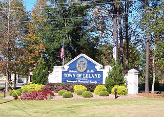
Leland is the most populous town in Brunswick County, North Carolina, United States. The population was 23,504 at the 2020 census, up from 13,527 in 2010. As of 2020, it is considered to be one of the fastest growing towns in North Carolina. It is part of the Wilmington, NC Metropolitan Statistical Area. and the Cape Fear Council of Governments. The town of Leland is in the northeastern part of Brunswick County, with the town of Navassa to the north, Belville to east, and Boiling Spring Lakes to the south. It is part of the Town Creek township, and Cape Fear region of North Carolina, a short distance north of the South Carolina state line. Leland is located five miles (8.0 km) west of Wilmington, 71 miles (114 km) north of Myrtle Beach, 84 miles (135 km) southeast of Fayetteville, and 135 miles (217 km) southeast of Raleigh.

<span class="mw-page-title-main">Carolina Beach, North Carolina</span> Town in North Carolina, United States

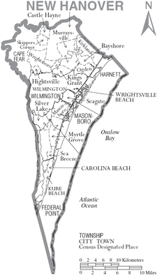
Carolina Beach is a beach town in New Hanover County, North Carolina, United States, situated about 12 miles (19 km) south of Wilmington International Airport in southeastern coastal North Carolina. As of the 2020 census, the city population was 6,564. It is part of the Wilmington metropolitan area. The community of Wilmington Beach was annexed by the town in 2000.

<span class="mw-page-title-main">Wilmington, North Carolina</span> City in North Carolina, United States

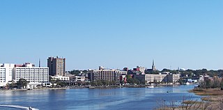
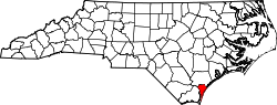
Wilmington is a port city in and the county seat of New Hanover County in coastal southeastern North Carolina, United States. With a population of 115,451 in the 2020 census, it is the eighth-most populous city in the state. Wilmington is the principal city of the Wilmington, NC Metropolitan Statistical Area, which includes New Hanover, Brunswick, and Pender counties. Its metropolitan statistical area had an estimated population of 467,337 in 2023.

<span class="mw-page-title-main">Interstate 140 (North Carolina)</span> Highway in North Carolina

Interstate 140 (I-140) and North Carolina Highway 140 (NC 140) is a 25.4-mile (40.9 km) auxiliary Interstate Highway and state highway in the U.S. state of North Carolina. Officially designated the John Jay Burney Jr. Freeway, it serves as a bypass of Wilmington. The western terminus of the highway is at U.S. Route 17 (US 17) near Winnabow. It heads north in western Leland before turning to the east north of an interchange with U.S. Route 74 (US 74)/U.S. Route 76 (US 76). I-140 crosses the Cape Fear River north of Navassa and the Northeast Cape Fear River northwest of Wrightsboro. I-140 ends at Interstate 40 (I-40), and the route number changes to NC 140. NC 140 continues to the east, ending at US 17 in Kirkland.

<span class="mw-page-title-main">Cape Fear (region)</span> Wilmington metropolitan area

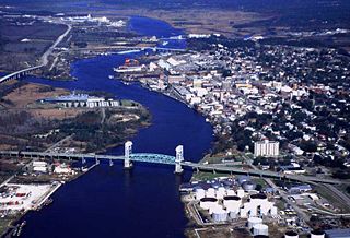
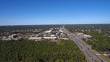
Cape Fear is a coastal plain and Tidewater region of North Carolina centered about the city of Wilmington. The region takes its name from the adjacent Cape Fear headland, as does the Cape Fear River which flows through the region and empties into the Atlantic Ocean near the cape. Much of the region's populated areas are found along the Atlantic beaches and the Atlantic Intracoastal Waterway, while the rural areas are dominated by farms and swampland like that of the Green Swamp. The general area can be also identified by the titles "Lower Cape Fear", "Wilmington, NC Metropolitan Statistical Area", "Southeastern North Carolina", and "Azalea Coast". The latter name is derived from the North Carolina Azalea Festival held annually in Wilmington. Municipalities in the area belong to the Cape Fear Council of Governments.

<span class="mw-page-title-main">Pleasure Island (North Carolina)</span> Coastal barrier island in North Carolina

Pleasure Island is a coastal barrier island in Southeastern North Carolina, United States, just south of the City of Wilmington. Pleasure Island is located within Federal Point Township, in New Hanover County. The coastal resort towns of Carolina Beach and Kure Beach, as well as the annexed communities of Wilmington Beach and Hanby Beach are located on the island. The southern end of Pleasure Island was separated from Bald Head Island by Corncake Inlet until the inlet was shoaled and closed in 1998 by Hurricane Bonnie; thus Pleasure Island and Bald Head Island are no longer separate islands.

<span class="mw-page-title-main">U.S. Route 421 in North Carolina</span> Highway in North Carolina

U.S. Route 421 (US 421) is part of the United States Numbered Highway System that runs from Fort Fisher, North Carolina to Michigan City, Indiana. In the U.S. state of North Carolina, US 421 travels 328 miles (528 km) from its southern terminus at Fort Fisher to the Tennessee state line near the community of Zionville, North Carolina. US 421 traverses the state from east to west travelling from the coastal plains to Appalachian Mountains. It provides an important connection between the cities of Wilmington, Sanford, Greensboro, Winston-Salem, and Boone. Despite being signed as north–south, much of the routing of US 421 in North Carolina runs in an east–west direction, particularly between Greensboro and the Tennessee state line. Portions of US 421 have been upgraded to freeway standards including the majority of its routing between Sanford and North Wilkesboro.

<span class="mw-page-title-main">North Carolina Highway 133</span> State highway in North Carolina, US

North Carolina Highway 133 (NC 133) is a primary state highway in the U.S. state of North Carolina. It traverses 46.6 miles (75.0 km) from Oak Island Drive in Oak Island to NC 210 in Bells Crossroads. The route serves communities such as Southport, Belville, Leland, Wilmington, and Castle Hayne. Additionally, NC 133 serves as an entry point for Military Ocean Terminal Sunny Point located to its east. Much of NC 133 runs parallel to the Cape Fear River and Brunswick River between Southport and Belville. West of Wilmington, NC 133 runs concurrently with U.S. Route 17 (US 17), US 74, and US 76. The road follows another concurrency along US 74 and US 421, west of Downtown Wilmington, and crosses into New Hanover County on the Isabel Holmes Bridge. North of Wilmington, NC 133 exits to the north, serving several suburban communities north of Wilmington. NC 133 runs concurrently with US 117 through Castle Hayne, before bearing northwest toward Bells Crossroads.

<span class="mw-page-title-main">Fort Caswell Historic District</span> Historic district in North Carolina, United States

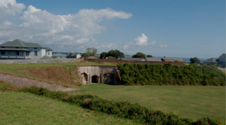
Located in North Carolina on the Atlantic Coast, the Fort Caswell Historic District encompasses 2 sites, 43 buildings, and 23 structures; it was added to the National Register of Historic Places in 2013. The fort itself was occupied by various branches of the U.S. armed forces for most of the period between 1836 and 1945 and is now a part of the North Carolina Baptist Assembly, a Christian retreat, owned and operated by the Baptist State Convention of North Carolina. It is accessible by the public to a limited extent per the conditions set forth by the Assembly’s Director.

The following is a timeline of the history of the city of Wilmington, North Carolina, United States.

References

  1. 1 2 3 "QuickFacts: New Hanover County, North Carolina". United States Census Bureau. Retrieved March 21, 2024.
  2. "North Carolina Land Area County Rank". USA.com. Retrieved September 17, 2018.
  3. "Find a County". National Association of Counties. Retrieved June 7, 2011.
  4. "North Carolina: Individual County Chronologies". North Carolina Atlas of Historical County Boundaries. The Newberry Library. 2009. Archived from the original on March 4, 2016. Retrieved January 25, 2015.
  5. Proffitt, Martie (April 17, 1983). "Local history offers tasty tidbits". Star-News. pp. 8C. Retrieved November 1, 2015.
  6. Lennon, Donald R.; SLNC Government and Heritage Library (2006). Powell, William S. (ed.). "Cape Fear River Settlements". NCpedia. University of North Carolina Press. Retrieved October 29, 2023.
  7. "Lynching in America/Supplement: Lynching by County, 3rd edition" Archived October 23, 2017, at the Wayback Machine , 2017, Montgomery, Alabama: Equal Justice Initiative, p. 7
  8. Johnson, Allen. "Allen Johnson: Lynching memorial a stark reminder of terrorism in America". Greensboro News and Record. Retrieved March 12, 2023.
  9. "1898 Wilmington Coup". www.dncr.nc.gov. Retrieved October 29, 2023.
  10. Zucchino, David (July 1, 2020). "The 1898 Wilmington Massacre Is an Essential Lesson in How State Violence Has Targeted Black Americans". Time. Retrieved October 29, 2023.
  11. Still, Johanna F. (June 22, 2020). "County quietly removed at least three Hugh MacRae Park signs after they were vandalized". Port City Daily. Retrieved October 29, 2023.
  12. Weller, Frances (July 14, 2020). "Hugh MacRae Park name change to take place immediately, signs removed". WECT. Retrieved October 29, 2023.
  13. Medlin, Eric (2022). "Jim Crow". NCpedia. Retrieved October 29, 2023.
  14. "2020 County Gazetteer Files – North Carolina". United States Census Bureau. August 23, 2022. Retrieved September 9, 2023.
  15. 1 2 "NCWRC Game Lands". www.ncpaws.org. Retrieved March 30, 2023.
  16. "Freeman Park". www.carolinabeach.org. Retrieved June 14, 2023.
  17. "Pages Creek Park Preserve". www.nhcgov.com. Retrieved September 12, 2023.
  18. Wood, Andy; Shew, Roger (March 30, 2023). "Island Creek Basin Ecosystems: An Imperiled Biodiversity Hotspot". newhanoversheriff.com. Retrieved May 3, 2023.
  19. "Prince George Creek Near Wrightsboro, NC (USGS-02108622)". www.waterqualitydata.us. April 23, 2023. Retrieved April 23, 2023.
  20. Nunn, Scott (January 4, 2022). "Eagles Island is mostly undeveloped. That wasn't always the case". WHQR. Retrieved April 15, 2024.
  21. "U.S. Decennial Census". United States Census Bureau. Retrieved January 18, 2015.
  22. "Historical Census Browser". University of Virginia Library. Retrieved January 18, 2015.
  23. Forstall, Richard L., ed. (March 27, 1995). "Population of Counties by Decennial Census: 1900 to 1990". United States Census Bureau. Retrieved January 18, 2015.
  24. "Census 2000 PHC-T-4. Ranking Tables for Counties: 1990 and 2000" (PDF). United States Census Bureau. April 2, 2001. Archived (PDF) from the original on March 27, 2010. Retrieved January 18, 2015.
  25. "State & County QuickFacts". United States Census Bureau. Retrieved October 27, 2013.[ permanent dead link ]
  26. "Explore Census Data". data.census.gov. Retrieved December 24, 2021.
  27. "U.S. Census website". United States Census Bureau . Retrieved January 31, 2008.
  28. "County Commissioners & Clerk : About Us". New Hanover County. Retrieved October 27, 2023.
  29. "Directory of Representatives". house.gov. Retrieved April 19, 2024.
  30. "New Hanover County Representation". North Carolina General Assembly. Retrieved April 19, 2024.
  31. 1 2 Still, Johanna; Cunningham, Eric (October 25, 2023). "Battle for the 'Burbs". The Assembly. Archived from the original on October 26, 2023.
  32. Still, Johanna F. (November 6, 2020). "With polarization seemingly reaching all-time highs, New Hanover, N.C. still purple". Port City Daily. Retrieved October 26, 2023.
  33. Leip, David. "Dave Leip's Atlas of U.S. Presidential Elections". uselectionatlas.org. Retrieved March 16, 2018.
  34. Rau, Jordan (January 28, 2021). "In the midst of the pandemic, a public hospital is gobbled up". Fortune Magazine . Retrieved November 19, 2021.
  35. "Annual Financial Report New Hanover Regional Medical Center Wilmington, North Carolina (A Component Unit of New Hanover County, North Carolina) Years Ended September 30, 2019 and 2018 With Report of Independent Auditor" (PDF). New Hanover Regional Medical Center. Archived (PDF) from the original on January 30, 2021. Retrieved November 19, 2021.
  36. Paavola, Alia (February 1, 2021). "Novant buys North Carolina health system". Beckers Hospital Review. Retrieved November 19, 2021.