Lumberton, North Carolina

Last updated

Lumberton, North Carolina
Downtown Lumberton North Carolina.jpg
North Elm Street
Lumberton, NC City Seal.jpg
USA North Carolina location map.svg
Red pog.svg
Lumberton
Location within the state of North Carolina
Usa edcp location map.svg
Red pog.svg
Lumberton
Lumberton (the United States)
Coordinates: 34°37′52″N79°01′07″W / 34.63111°N 79.01861°W / 34.63111; -79.01861
CountryUnited States
State North Carolina
County Robeson
Named for Lumber River [1]
Government
Area
[2]
  Total17.84 sq mi (46.20 km2)
  Land17.76 sq mi (46.00 km2)
  Water0.08 sq mi (0.20 km2)
Elevation
[3]
135 ft (41 m)
Population
 (2020)
  Total19,025
  Density1,071.29/sq mi (413.62/km2)
Time zone UTC−5 (Eastern (EST))
  Summer (DST) UTC−4 (EDT)
ZIP codes
28358-28360
Area codes 910, 472
FIPS code 37-39700 [4]
GNIS feature ID2404974 [3]
Website www.ci.lumberton.nc.us

Lumberton is a city in Robeson County, North Carolina, United States. As of 2020, its population was 19,025. [5] It is the seat of Robeson County's government. [6]

Contents

Located in southern North Carolina's Inner Banks region, Lumberton is located on the Lumber River. It was founded in 1787 by John Willis, an officer in the American Revolution. This was developed as a shipping point for lumber used by the Navy, and logs were guided downriver to Georgetown, South Carolina. Most of the town's growth took place after World War II.

David Lynch’s 1986 film Blue Velvet was set in Lumberton; however filming took place in Wilmington. [7]

History

Robeson County, North Carolina, was formed in 1787. General John Willis, owner of the Red Banks plantation, lobbied to have the county's new seat of government located on his land. The site of Lumberton was chosen due to its central location in the county, proximity to a reliable ford of the Lumber River, and as it was where several roads intersected. Willis turned over 170 acres, which were surveyed and disbursed in a lottery held under the auspices of the county court on August 14, 1787. As the site was heavily forested, trees were felled to make way for a courthouse, business and residential lots, streets, a commons, and a public square. The first courthouse was a wooden residence sold by Willis to the county and moved into place after the land was clear. Lumberton was formally created by an act of the North Carolina General Assembly on November 3, 1788, which granted the town a charter and the power to levy taxes. The community was named in homage to the Lumber River. [8]

Aside from the courthouse, the first buildings in Lumberton were a handful of brick structures built near the river, which included a hotel, stores, and warehouses, which were stocked by goods sent up the river from Georgetown, South Carolina. [8] The community's first school was established by Willis in 1791. [9] The town had a post office by 1796. It was formally incorporated in 1852 and granted a municipal government with a mayor and a board of commissioners. [8] The town was connected by rail with Wilmington in 1860, which reduced its reliance on river trade from Georgetown. Much of the business district was burnt down in a fire in 1870 and another in 1876. [10]

Robeson County Courthouse in Lumberton, 1948 Robeson County Courthouse, 1948.jpg
Robeson County Courthouse in Lumberton, 1948

For four seasons, 1947–50, Lumberton fielded a professional minor-league baseball team in the Tobacco State League. Affiliated with the Chicago Cubs, the team was known as the Lumberton Cubs in 1947 and '48, and the Lumberton Auctioneers in 1949 and '50. [11]

In 1970, Lumberton was named an All-America City, presented by the National Civic League. [12] Many businesses left the downtown in the mid-1970s. [13] A 1988 hostage crisis at the offices of The Robesonian and the 1993 murder of James R. Jordan Sr. nearby generated a negative national image for the city. In 1995, the city won the All-America City award a second time. [14]

In 2016, Robeson County was impacted by Hurricane Matthew, leading to record flooding in Lumberton. In 2018, the county was struck by Hurricane Florence, which broke the flooding record. [15] As a result of extensive damage to homes, entire streets in south and west Lumberton were left abandoned. [16]

The Baker Sanatorium, Luther Henry Caldwell House, Carolina Theatre, Humphrey-Williams Plantation, Lumberton Commercial Historic District, Planters Building, Robeson County Agricultural Building, Alfred Rowland House, and US Post Office-Lumberton are listed on the National Register of Historic Places. [17] [18]

Geography

Lumberton lies within the Carolina Border Belt, a regional network of tobacco markets and warehouses along both sides of the North Carolina-South Carolina border. [19]

According to the United States Census Bureau, the city has a total area of 15.8 square miles (40.9 km2), of which 0.1 sq mi (0.2 km2) (0.44%) is covered by water.

Lumberton is located on the Lumber River in the state's Coastal Plains region. The Lumber River State Park, 115 miles (185 km) of natural and scenic waterway, flows through Lumberton.

Lumberton is served by Interstate 95 and Interstate 74.

Climate

Lumberton experiences a humid subtropical climate with hot, humid summers and cool winters.

Climate data for LUMBERTON MUNI AP, NC, 1991-2020 normals, extremes 1903-present
MonthJanFebMarAprMayJunJulAugSepOctNovDecYear
Record high °F (°C)82
(28)
84
(29)
96
(36)
96
(36)
101
(38)
104
(40)
108
(42)
106
(41)
104
(40)
99
(37)
87
(31)
83
(28)
108
(42)
Mean daily maximum °F (°C)54.6
(12.6)
58.6
(14.8)
65.8
(18.8)
74.7
(23.7)
82.5
(28.1)
88.8
(31.6)
91.0
(32.8)
89.1
(31.7)
84.2
(29.0)
75.9
(24.4)
65.9
(18.8)
57.5
(14.2)
74.1
(23.4)
Daily mean °F (°C)44.9
(7.2)
48.0
(8.9)
54.5
(12.5)
62.7
(17.1)
71.0
(21.7)
78.8
(26.0)
81.6
(27.6)
80.0
(26.7)
74.5
(23.6)
64.2
(17.9)
54.1
(12.3)
47.5
(8.6)
63.5
(17.5)
Mean daily minimum °F (°C)35.3
(1.8)
37.4
(3.0)
43.1
(6.2)
50.7
(10.4)
59.5
(15.3)
68.7
(20.4)
72.3
(22.4)
70.9
(21.6)
64.8
(18.2)
52.5
(11.4)
42.4
(5.8)
37.5
(3.1)
52.9
(11.6)
Record low °F (°C)−1
(−18)
3
(−16)
9
(−13)
22
(−6)
29
(−2)
40
(4)
50
(10)
44
(7)
35
(2)
20
(−7)
12
(−11)
−2
(−19)
−2
(−19)
Average precipitation inches (mm)2.55
(65)
2.77
(70)
3.26
(83)
2.85
(72)
3.41
(87)
4.92
(125)
4.61
(117)
4.77
(121)
4.93
(125)
2.29
(58)
2.95
(75)
3.31
(84)
42.62
(1,083)
Average precipitation days (≥ 0.01 in)9.18.79.68.310.011.512.213.410.37.87.99.3118.1
Source: NOAA [20] [21]

Demographics

Historical population
CensusPop.Note
1870 615
1880 533−13.3%
1890 5849.6%
1900 84945.4%
1910 2,230162.7%
1920 2,69120.7%
1930 4,14053.8%
1940 5,80340.2%
1950 9,18658.3%
1960 15,30566.6%
1970 16,96110.8%
1980 18,2417.5%
1990 18,6012.0%
2000 20,79511.8%
2010 21,5423.6%
2020 19,025−11.7%
U.S. Decennial Census [22]
Location of the Lumberton-Laurinburg CSA and its components:
.mw-parser-output .legend{page-break-inside:avoid;break-inside:avoid-column}.mw-parser-output .legend-color{display:inline-block;min-width:1.25em;height:1.25em;line-height:1.25;margin:1px 0;text-align:center;border:1px solid black;background-color:transparent;color:black}.mw-parser-output .legend-text{}
Lumberton Micropolitan Statistical Area
Laurinburg Micropolitan Statistical Area Lumberton-Laurinburg CSA.png
Location of the Lumberton-Laurinburg CSA and its components:
  Lumberton Micropolitan Statistical Area
  Laurinburg Micropolitan Statistical Area

Lumberton is the larger principal city of the Fayetteville-Lumberton-Pinehurst, NC Combined Statistical Area that includes the Lumberton (Robeson County) and Laurinburg (Scotland County) micropolitan areas. [23] [24] [25] The CSA had a combined population of 520,378 at the 2020 census. [26]

2020 census

Lumberton racial composition [27]
Race Num.Perc.
White (non-Hispanic)6,65734.99%
Black or African American (non-Hispanic)6,76435.55%
Native American 2,50013.14%
Asian 3791.99%
Pacific Islander 230.12%
Other/mixed8144.28%
Hispanic or Latino1,8889.92%

As of the 2020 United States census, 19,025 people, 7,142 households, and 4,536 families resided in the city.

2010 census

As of the 2010 United States Census, 21,542 people were living in the city. The racial makeup of the city was 39.0% White, 36.7% Black, 12.7% Native American, 2.4% Asian, 0.1% Pacific Islander, 0.1% from some other race, and 2.2% from two or more races. About 6.7% were Hispanic or Latino of any race.

2000 census

As of the census [4] of 2000, 20,795 people, 7,827 households and 5,165 families were residing in Lumberton. The population density was 1,322.4 inhabitants per square mile (510.6/km2). The 8,800 housing units had an average density of 559.6 per square mile (216.1/km2). The racial makeup of the city was 48.54% White, 35.44% African American, 12.79% Native American, 0.91% Asian, 1.21% from other races, and 1.11% from two or more races. Hispanicss or Latinoss of any race were 3.30% of the population.

Of the 7,827 households, 32.2% had children under 18 living with them; 38.8% were married couples living together; 23.0% had a female householder with no husband present, and 34.0% were not families. About 29.9% of all households were made up of individuals, and 12.6% had someone living alone who was 65 or older. The average household size was 2.44, and the average family size was 3.01. Children of high-school age (grades 9–12) attend Lumberton High School, which is run by the Public Schools of Robeson County, [28] as it is in Robeson County.

The city's age distribution was 26.3% under 18; 9.3% from 18 to 24; 28.2% from 25 to 44; 21.3% from 45 to 64; and 14.8% who were 65 or older. The median age was 35 years. For every 100 females, there were 89.1 males. For every 100 females 18 and over, there were 85.8 males.

The median income for a household in Lumberton was $26,782, and for a family was $33,839. Males had a median income of $28,903 versus $24,503 for females. The per capita income for the city was $15,504. About 23.9% of families and 25.9% of the population were below the poverty line, including 38.4% of those under age 18 and 23.7% of those age 65 or over.

Government

Former Lumberton Municipal Building Former Lumberton Municipal Building.jpg
Former Lumberton Municipal Building

Lumberton is headed by a council–manager government. [29] The city supplies electric utility services to its residents. [30]

Education

Public Schools of Robeson County operates public schools. [31]

Notable people

    Related Research Articles

    <span class="mw-page-title-main">Scotland County, North Carolina</span> County in North Carolina, United States

    Scotland County is a county located in the southern part of the U.S. state of North Carolina. Its county seat is and largest community is Laurinburg. The county was formed in 1899 from part of Richmond County and named in honor of the Scottish settlers who occupied the area in the 1700s. As of the 2020 census, its population was 34,174.

    <span class="mw-page-title-main">Robeson County, North Carolina</span> County in North Carolina, United States

    Robeson County is a county in the southern part of the U.S. state of North Carolina and is its largest county by land area. Its county seat and largest community is Lumberton. The county was formed in 1787 from part of Bladen County and named in honor of Thomas Robeson, a colonel who had led Patriot forces in the area during the Revolutionary War. As of the 2020 census, the county's population was 116,530. It is a majority-minority county; its residents are approximately 38 percent Native American, 22 percent white, 22 percent black, and 10 percent Hispanic. It is included in the Fayetteville-Lumberton-Pinehurst, NC Combined Statistical Area. The state-recognized Lumbee Tribe of North Carolina is headquartered in Pembroke.

    <span class="mw-page-title-main">Pasquotank County, North Carolina</span> County in North Carolina, United States

    Pasquotank County is a county located in the U.S. state of North Carolina. As of the 2020 census, the population was 40,568. Its county seat is Elizabeth City.

    <span class="mw-page-title-main">Lee County, North Carolina</span> County in North Carolina, United States

    Lee County is a county located in the U.S. state of North Carolina. As of the 2020 census, the population was 63,285. The county seat is Sanford.

    <span class="mw-page-title-main">Johnston County, North Carolina</span> County in North Carolina, United States

    Johnston County is a county located in the U.S. state of North Carolina. As of the 2020 census, the population was 215,999. Its county seat is Smithfield.

    <span class="mw-page-title-main">Hoke County, North Carolina</span> County in North Carolina, United States

    Hoke County is a county in the U.S. state of North Carolina. As of the 2020 census, its population was 52,082. Its county seat is Raeford.

    <span class="mw-page-title-main">Durham County, North Carolina</span> County in North Carolina, United States

    Durham County is a county located in the U.S. state of North Carolina. As of the 2020 census, the population was 324,833, making it the sixth-most populous county in North Carolina. Its county seat is Durham, which is the only incorporated municipality predominantly in the county, though very small portions of cities and towns mostly in neighboring counties also extend into Durham County. The central and southern parts of Durham County are highly urban, consisting of the city as well as several unincorporated suburbs. Southeastern Durham County is dominated by the Research Triangle Park, most of which is in Durham County. The northern third of Durham County is rural in nature.

    <span class="mw-page-title-main">Cleveland County, North Carolina</span> County in North Carolina, United States

    Cleveland County is a county located in the foothills of the Blue Ridge Mountains and the western Piedmont, on the southern border of the U.S. state of North Carolina. As of the 2020 census, the population was 99,519. Its county seat is Shelby. Cleveland County comprises the Shelby-Kings Mountain, NC Micropolitan Statistical Area, which is also included in the Charlotte-Concord, NC-SC Combined Statistical Area.

    <span class="mw-page-title-main">Raeford, North Carolina</span> City in North Carolina, United States

    Raeford is a city in Hoke County, North Carolina, United States. Its population was 4,559 at the 2020 census. It is the county seat of Hoke County.

    <span class="mw-page-title-main">Jacksonville, North Carolina</span> City in North Carolina, United States

    Jacksonville is a city in Onslow County, North Carolina, United States. As of the 2020 census, the population was 72,723, which makes Jacksonville the 14th-most populous city in North Carolina. Jacksonville is the county seat and most populous community of Onslow County, which is coterminous with the Jacksonville, NC Metropolitan Statistical Area. Demographically, Jacksonville is the youngest city in the United States, with an average age of 22.8 years old, which can be attributed to the large military presence. The low age may also be in part due to the population drastically going up over the past 80 years, from 783 in the 1930 census to 72,723 in the 2020 census.

    <span class="mw-page-title-main">Rockingham, North Carolina</span> City in North Carolina, United States

    Rockingham is a city in Richmond County, North Carolina, United States, named after the Marquess of Rockingham. The population was 9,558 at the 2010 census. It is the county seat of Richmond County.

    <span class="mw-page-title-main">Fairmont, North Carolina</span> Town in North Carolina, United States

    Fairmont is a town in Robeson County, North Carolina, United States. The population was 2,663 at the 2010 census.

    <span class="mw-page-title-main">St. Pauls, North Carolina</span> Town in North Carolina, United States

    St. Pauls is a town in Robeson County, North Carolina, United States. The population was 2,035 at the 2010 census.

    <span class="mw-page-title-main">Red Springs, North Carolina</span> Town in North Carolina, United States

    Red Springs is a town in Robeson counties in the U.S. state of North Carolina. The population was 3,428 at the 2010 census.

    The Lumbee are a Native American people primarily centered in Robeson, Hoke, Cumberland, and Scotland counties in North Carolina.

    <span class="mw-page-title-main">Lumber River</span> River in North Carolina, United States

    The Lumber River, sometimes referred to as the Lumbee River, is a 133-mile-long (214 km) river in south-central North Carolina in the flat Coastal Plain. European settlers first called the river Drowning Creek, which is still used as the name of its headwater. The waterway known as the Lumber River extends downstream from the Scotland County-Hoke County border to the North Carolina-South Carolina border. Soon after crossing into South Carolina, the Lumber River flows into the Little Pee Dee River, which flows into the Pee Dee River, or Great Pee Dee River. Finally, the combined waters flow into Winyah Bay and the Atlantic Ocean.

    <span class="mw-page-title-main">Asheville metropolitan area</span> Metropolitan area in North Carolina, United States

    The Asheville metropolitan area is a metropolitan area centered on the principal city of Asheville, North Carolina. The U.S. Office of Management and Budget defines the Asheville, NC Metropolitan Statistical Area, a metropolitan statistical area used by the United States Census Bureau and other entities, as comprising the four counties of Buncombe, Haywood, Henderson, and Madison. The area's population was 424,858 according to the 2010 census, and 469,454 according to the 2020 census.

    <span class="mw-page-title-main">North Carolina Highway 711</span> State highway in Robeson County, North Carolina, US

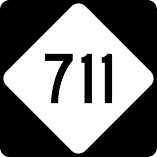
    North Carolina Highway 711 (NC 711) is a primary state highway in the U.S. state of North Carolina. It connects the town of Pembroke with Interstate 95 (I-95) and U.S. Route 301 (US 301) in Lumberton. The highway travels in an east-to-west orientation but is signed as a north-south highway, entirely in Robeson County.

    Lumberton Senior High School is a high school located in Lumberton, North Carolina, serving grades 9–12. It is run by the Public Schools of Robeson County, as it is in Robeson County, North Carolina.

    <span class="mw-page-title-main">Horace Locklear</span> American politician

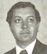
    Horace Locklear is an American politician and former attorney who served in the North Carolina House of Representatives from 1977 until 1983. A member of the Lumbee tribe, he was the first Native American to practice law in North Carolina.

    References

    1. "North Carolina Gazetteer" . Retrieved December 12, 2022.
    2. "ArcGIS REST Services Directory". United States Census Bureau. Retrieved September 20, 2022.
    3. 1 2 U.S. Geological Survey Geographic Names Information System: Lumberton, North Carolina
    4. 1 2 "U.S. Census website". United States Census Bureau . Retrieved January 31, 2008.
    5. "Explore Census Data". data.census.gov. Retrieved August 4, 2022.
    6. "Find a County". National Association of Counties. Retrieved June 7, 2011.
    7. Rossellini, Isabella (1997). Some of Me . New York: Random House. ISBN   978-0-679-45252-2.
    8. 1 2 3 "Lumberton Lots Disposed Of By Lottery; By 1852 Town Had Mayor, Three Stores; Growth Phenomenal In Last Century". The Robesonian. February 26, 1951. p. 1A.
    9. "Lumberton's First School Began 1791". The Robesonian. February 26, 1951. p. 1A.
    10. "Customs Were Different Then-- Fishing Parties, Cider Shops". The Robesonian. February 26, 1951. p. 4A.
    11. Holaday, Chris (2016). "The Tobacco State League; A North Carolina Baseball History, 1946–1950".. Jefferson, N.C.: McFarland. ISBN   978-1-4766-6670-9.
    12. "High Point of City's History Was Being Named All-American". The Robesonian. March 23, 1971. pp. 1E, 4E.
    13. Nagem, Sarah (November 29, 2022). "Downtown Lumberton envisions a big transformation, starting with Carolina Civic Center". Border Belt Independent. Retrieved December 2, 2022.
    14. Thompson, Estes (July 6, 1995). "All-America City award giving Lumberton opportunity to shake negative image". The Herald-Sun. Associated Press. p. C8.
    15. Dreilinger, Danielle (October 28, 2022). "Learning to live with water, again: Lumbee face hard decisions about nature and NC storms". The Fayetteville Observer. Archived from the original on October 28, 2022.
    16. Marson & Legerton 2021, pp. 2248–2249.
    17. "National Register Information System". National Register of Historic Places . National Park Service. July 9, 2010.
    18. "National Register of Historic Places Listings". Weekly List of Actions Taken on Properties: 4/16/12 through 4/20/12. National Park Service. April 27, 2012. Archived from the original on February 22, 2014. Retrieved March 29, 2015.
    19. Yeargin, W.W. (2006). "Tobacco Belts". NCPedia. North Carolina Government & Heritage Library. Retrieved July 21, 2022.
    20. "NOWData – NOAA Online Weather Data". National Oceanic and Atmospheric Administration.
    21. "Summary of Monthly Normals 1991-2020". National Oceanic and Atmospheric Administration . Retrieved January 1, 2022.
    22. "Census of Population and Housing". Census.gov. Retrieved June 4, 2015.
    23. MICROPOLITAN STATISTICAL AREAS AND COMPONENTS Archived 2007-06-29 at the Wayback Machine , Office of Management and Budget, 2007-05-11. Accessed 2008-08-01.
    24. COMBINED STATISTICAL AREAS AND COMPONENT CORE BASED STATISTICAL AREAS Archived 2007-06-29 at the Wayback Machine , Office of Management and Budget, 2007-05-11. Accessed 2008-08-01.
    25. "OMB Bulletin No. 23-01: Revised Delineations of Metropolitan Statistical Areas, Micropolitan Statistical Areas, and Combined Statistical Areas, and Guidance on Uses of the Delineations of These Areas" (PDF). United States Office of Management and Budget . July 21, 2023. Retrieved August 10, 2023.
    26. "2020 Population and Housing State Data". August 10, 2023. United States Census Bureau, Population Division. May 18, 2023.
    27. "Explore Census Data". data.census.gov. Retrieved December 10, 2021.
    28. "Contact Us / School Contact Numbers". Archived from the original on March 1, 2017. Retrieved March 15, 2017.
    29. "History". City of Lumberton. Retrieved November 5, 2022.
    30. "Local electric providers take precautions after Moore County substation attack". The Robesonian. December 6, 2022. Retrieved December 8, 2022.
    31. "Public Schools of Robeson County". www.robeson.k12.nc.us. Retrieved August 11, 2023.

    Works cited