Mitchell County, North Carolina

Last updated

Mitchell County
Mitchell County Courthouse.jpg
Old Mitchell County Courthouse in Bakersville
Mitchell County Flag.gif
Mitchell County Seal.png
Map of North Carolina highlighting Mitchell County.svg
Location within the U.S. state of North Carolina
North Carolina in United States.svg
North Carolina's location within the U.S.
Coordinates: 36°01′N82°10′W / 36.01°N 82.16°W / 36.01; -82.16
CountryFlag of the United States.svg United States
StateFlag of North Carolina.svg  North Carolina
Founded1861
Named for Elisha Mitchell [1]
Seat Bakersville
Largest community Spruce Pine
Area
  Total221.88 sq mi (574.7 km2)
  Land221.25 sq mi (573.0 km2)
  Water0.63 sq mi (1.6 km2)  0.28%
Population
 (2020)
  Total14,903
  Estimate 
(2023)
14,999
  Density67.36/sq mi (26.01/km2)
Time zone UTC−5 (Eastern)
  Summer (DST) UTC−4 (EDT)
Congressional district 5th
Website www.mitchellcounty.org

Mitchell County is a county located in the U.S. state of North Carolina. As of the 2020 census, the population was 14,903. [2] Its county seat is Bakersville. [3]

Contents

The county is home to Spruce Pine, nicknamed the "Mineral City of the World", [4] and Bakersville, "Gateway to Roan Mountain", which includes the world's largest natural rhododendron garden and the longest stretch of grassy bald in the Appalachian range. [5] Throughout the year such festivals as North Carolina Mineral and Gem Festival and North Carolina Rhododendron Festival bring visitors to the area. [6] [7]

History

The county was formed in 1861 from parts of Burke County, Caldwell County, McDowell County, Watauga County, and Yancey County. It was named for Elisha Mitchell, professor of mathematics, chemistry, geology, and mineralogy at the University of North Carolina from 1818 until his death in 1857. Dr. Mitchell was the first scientist to argue that a nearby peak in the Black Mountains was the highest point east of the Mississippi River. He measured the mountain's height and climbed and explored it. In 1857 he fell to his death on a waterfall on the side of the mountain. The mountain was subsequently named Mount Mitchell in his honor.

By 1899, Mitchell County had a sundown town policy of preventing Black Americans from living or working in the county. [8] By the early 1920s, Black Americans began working and living in the county in larger numbers, especially as mine workers and as convict laborers constructing local infrastructure, including new state highways such as what is now US Highway 19E. In September 1923, a 75-year-old White woman named Alice Thomas accused John Goss, an escaped Black convict laborer, of raping her. A White mob formed in Spruce Pine, and when they could not locate the fugitive Goss, the mob (which included members of the Ku Klux Klan) forced nearly all of the Black people onto train cars heading out of the county. Governor Cameron Morrison, an ally of the infrastructure construction and mining industries, declared martial law and called in the National Guard in an attempt to stop the mob violence, but by the time the Guard units arrived two days later, the Black mine and construction laborers had already been driven from the county. The National Guard occupied Spruce Pine for nearly two weeks. Despite Morrison's declaration of martial law having little effect, it was the first time martial law was declared in response to an instance of mass racial violence in the United States. Ultimately, 86 members of the White supremacist mob were indicted for their actions, many of whom pled guilty to minor offences. Goss was arrested in Hickory four days after the alleged rape, and at the orders of the Governor, jailed in Raleigh to avert lynching. He was tried three weeks later in Mitchell County, convicted by jury after five minutes of deliberation, and executed by electrocution. [9] [10]

The county took a direct hit from "The Storm of the Century", also known as the "’93 Superstorm", or "The (Great) Blizzard of 1993". This storm event was similar in nature to a hurricane. The storm occurred between March 12–13, 1993, on the East Coast of North America. Parts of Cuba, Gulf Coast States, Eastern United States and Eastern Canada were greatly impacted. The county suffered a tragic event on May 3, 2002, when a fire broke out at the Mitchell County jail in Bakersville, North Carolina. Eight men lost their lives in the fire.

Mitchell County was one of the three entirely dry counties in North Carolina, along with Graham and Yancey, but in March 2009, after much controversy, the Town of Spruce Pine approved beer, wine and limited retail sale.

Geography

Mitchell County, North Carolina
Interactive map of Mitchell County

According to the U.S. Census Bureau, the county has a total area of 221.88 square miles (574.7 km2), of which 221.25 square miles (573.0 km2) is land and 0.63 square miles (1.6 km2) (0.28%) is water. [11] It is the fourth-smallest county in North Carolina by land area and second-smallest by total area. The northwest sections of county border the state of Tennessee. Sections of both the Blue Ridge Parkway and Appalachian Trail are located in the county. Parts of the Pisgah National Forest are located in the northern sections of the county. Several conservation lands are within Pisgah National Forest in Mitchell and neighboring Avery County.

National protected areas

State and local protected areas

Major water bodies

Adjacent counties

Major highways

Demographics

Historical population
CensusPop.Note
1870 4,705
1880 9,435100.5%
1890 12,80735.7%
1900 15,22118.8%
1910 17,24513.3%
1920 11,278−34.6%
1930 13,96223.8%
1940 15,98014.5%
1950 15,143−5.2%
1960 13,906−8.2%
1970 13,447−3.3%
1980 14,4287.3%
1990 14,4330.0%
2000 15,6878.7%
2010 15,579−0.7%
2020 14,903−4.3%
2023 (est.)14,999 [2] 0.6%
U.S. Decennial Census [14]
1790–1960 [15] 1900–1990 [16]
1990–2000 [17] 2010 [18] 2020 [2]

2020 census

Mitchell County racial composition [19]
RaceNumberPercentage
White (non-Hispanic)13,51490.68%
Black or African American (non-Hispanic)500.34%
Native American 300.2%
Asian 520.35%
Pacific Islander 10.01%
Other/Mixed 5553.72%
Hispanic or Latino 7014.7%

As of the 2020 census, there were 14,903 people, 6,344 households, and 4,031 families residing in the county.

2000 census

At the 2000 census, [20] there were 15,687 people, 6,551 households, and 4,736 families residing in the county. The population density was 71 people per square mile (27 people/km2). There were 7,919 housing units at an average density of 36 units per square mile (14 units/km2). The racial makeup of the county was 97.87% White, 0.22% Black or African American, 0.45% Native American, 0.20% Asian, 0.66% from other races, and 0.60% from two or more races. 1.98% of the population were Hispanic or Latino of any race.

There were 6,551 households, out of which 27.40% had children under the age of 18 living with them, 60.90% were married couples living together, 8.10% had a female householder with no husband present, and 27.70% were non-families. 25.20% of all households were made up of individuals, and 12.00% had someone living alone who was 65 years of age or older. The average household size was 2.37 and the average family size was 2.82.

In the county, the population was spread out, with 21.20% under the age of 18, 6.80% from 18 to 24, 26.40% from 25 to 44, 27.10% from 45 to 64, and 18.60% who were 65 years of age or older. The median age was 42 years. For every 100 females there were 95.60 males. For every 100 females age 18 and over, there were 92.30 males.

The median income for a household in the county was $30,508, and the median income for a family was $36,367. Males had a median income of $26,550 versus $20,905 for females. The per capita income for the county was $15,933. About 10.70% of families and 13.80% of the population were below the poverty line, including 17.20% of those under age 18 and 16.40% of those age 65 or over.

Ancestry

As of 2015, the largest self-reported ancestry groups in Mitchell County were: [21]

AncestryPercent
(2015)
American Flag of the United States.svg 17.3%
English Flag of England.svg 14.7%
German Flag of Germany.svg 12.2%
Irish Flag of Ireland.svg 11.9%
Scotch-Irish Flag of Ulster.svg 9.8%
Scottish Flag of Scotland.svg 5.0%
French (except Basque) Flag of France.svg 2.3%
Italian Flag of Italy.svg 1.9%
Swedish Flag of Sweden.svg 1.6%
Dutch Flag of the Netherlands.svg 1.5%

Law and government

Mitchell County is a member of the regional High Country Council of Governments.

Politics

Owing to its Civil War-era Unionist sympathies, along with its rural character, Mitchell has continuously been an overwhelmingly Republican county, even during the "Solid South" Democratic era. No Democratic presidential candidate has carried Mitchell County since Samuel J. Tilden in 1876. However, since Tilden's win, every Republican candidate has obtained at least sixty percent of the county's vote, with the solitary exception of the 1912 election when the party was divided between the two candidacies of William Howard Taft and Theodore Roosevelt, the latter of whom carried the county.

As of October 2022, 58 percent of active voters in Mitchell County are registered Republicans—the highest such rate statewide—while Democrats have their lowest county registration rate. [22]

United States presidential election results for Mitchell County, North Carolina [23]
Year Republican Democratic Third party
No.%No.%No.%
2020 7,09078.42%1,86720.65%840.93%
2016 6,28277.59%1,59619.71%2182.69%
2012 5,80674.77%1,83823.67%1211.56%
2008 5,49970.09%2,23828.52%1091.39%
2004 5,68672.92%2,08026.67%320.41%
2000 4,98475.52%1,53523.26%811.23%
1996 3,87465.15%1,49625.16%5769.69%
1992 4,40562.79%1,72724.62%88312.59%
1988 4,62076.82%1,37722.90%170.28%
1984 4,73778.51%1,28621.31%110.18%
1980 4,32268.93%1,76528.15%1832.92%
1976 3,72864.50%2,03135.14%210.36%
1972 4,24083.45%80015.74%410.81%
1968 3,77872.65%81915.75%60311.60%
1964 3,26365.27%1,73634.73%00.00%
1960 4,83180.45%1,17419.55%00.00%
1956 4,26979.97%1,06920.03%00.00%
1952 4,00976.43%1,23623.57%00.00%
1948 2,90876.35%81821.48%832.18%
1944 3,19275.71%1,02424.29%00.00%
1940 3,29069.41%1,45030.59%00.00%
1936 3,38066.71%1,68733.29%00.00%
1932 3,79868.06%1,77331.77%90.16%
1928 3,43680.60%82719.40%00.00%
1924 1,54068.84%68930.80%80.36%
1920 2,15375.54%69724.46%00.00%
1916 1,29873.75%46226.25%00.00%
1912 20315.57%38529.52%71654.91%

2016 presidential primaries

In the 2016 Republican Primary in Mitchell County, Donald Trump received 1,775 votes (or 46.8 percent of the total votes) followed by Ted Cruz who came in second with 1,188 votes (or 31.3% of the total votes). In the 2016 Democratic Primary, Bernie Sanders received 450 votes (57.9% of the total) whereas Hillary Clinton only won 314 votes (40.4% of the total). [24] In the general election Donald Trump received 6,282 votes (or 77.6% of the total vote) whereas Hillary Clinton only received 1,596 votes (19.7% of the vote) and Libertarian Candidate Gary Johnson only received 138 votes (1.7% of total votes in the county). [25]

Economy

The Mitchell County Economic Development Commission (EDC) is a nine-member board with representatives from various business, education, and government sectors in the county. The goal of the board is to promote the establishment, development, and retention of businesses in Mitchell County. [26]

Top 10 employers ranked largest to smallest: [27]

  1. Mitchell County Board of Education
  2. Sibelco North America, Inc.
  3. Blue Ridge Medical Center, Lllp.
  4. Walmart Associates, Inc.
  5. Mayland Community College
  6. Mitchell County Government
  7. Hospice of the Blue Ridge
  8. Ingles Markets, Inc.
  9. Bombardier Motor Corp of America (BRP)
  10. The Quartz Corp USA

Education

Mitchell High School is a comprehensive four-year high school (9-12) centrally located in the community of Ledger when built in 1978.

Spruce Pine is home to three schools: Greenlee Primary (K-2), [28] Deyton Elementary (3–5), [29] and Harris Middle (6–8). [30] Bakersville is home to two schools: Gouge Primary (K-4) [31] and Bowman Middle (5–8). [32]

Mayland Community College also calls Mitchell County home. Founded by an act of the North Carolina General Assembly in 1971, Mayland hosts some 35 curriculum programs and provides vocational and technical training, along with college transfer opportunities to residents of the region. [33]

Penland School of Crafts is an educational facility located in the Penland Community. It is designed to educate students who will apply workable knowledge in creation of books, paper, clay, drawing, glass, iron, metals, photography, printmaking and letterpress, textiles, and wood. [34] [35] The school was established in the early 1920s, it is the largest and oldest professional crafts school in the United States.

Media

The county is served by The Mitchell News-Journal, a weekly newspaper printed by Community Newspapers, Inc. [36] and WTOE radio, at 1470 kHz on the AM dial to cover local news. [37]

Communities

Map of Mitchell County with municipal and township labels Map of Mitchell County North Carolina With Municipal and Township Labels.PNG
Map of Mitchell County with municipal and township labels

Towns

Townships

  • Bakersville
  • Bradshaw
  • Cane Creek
  • Fork Mountain-Little Rock Creek
  • Grassy Creek
  • Harrell
  • Poplar
  • Red Hill
  • Snow Creek
  • Spruce Pine

Unincorporated communities

See also

Related Research Articles

<span class="mw-page-title-main">Yancey County, North Carolina</span> County in North Carolina, United States

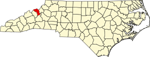
Yancey County is a county located in the U.S. state of North Carolina. As of the 2020 census, the population was 18,470. Its county seat is Burnsville.

<span class="mw-page-title-main">Watauga County, North Carolina</span> County in North Carolina, United States

Watauga County is a county located in the U.S. state of North Carolina. As of the 2020 census, the population was 54,086. Its county seat and largest community is Boone. The county is in an exceptionally mountainous region, known as the High Country. It is the home of Appalachian State University, which has approximately 20,023 students as of August 2020. Watauga County comprises the Boone, NC Micropolitan Statistical Area.

<span class="mw-page-title-main">Transylvania County, North Carolina</span> County in North Carolina, United States

Transylvania County is a county in the U.S. state of North Carolina. As of the 2020 census the population is 32,986. Its county seat is Brevard.

<span class="mw-page-title-main">Randolph County, North Carolina</span> County in North Carolina, United States

Randolph County is a county located in the U.S. state of North Carolina. As of the 2020 census, the population was 144,171. Its county seat is Asheboro.

<span class="mw-page-title-main">McDowell County, North Carolina</span> County in North Carolina, United States

McDowell County is a county located in the U.S. state of North Carolina. As of the 2020 census, the population was 44,578. Its county seat is Marion.

<span class="mw-page-title-main">Madison County, North Carolina</span> County in North Carolina, United States

Madison County is a county located in the U.S. state of North Carolina. As of the 2020 census, the population was 21,193. Its county seat is Marshall. Madison County is part of the Asheville, NC Metropolitan Statistical Area.

<span class="mw-page-title-main">Henderson County, North Carolina</span> County in North Carolina, United States

Henderson County is a county located in the U.S. state of North Carolina. As of the 2020 census, the population was 116,281. Its county seat is Hendersonville.

<span class="mw-page-title-main">Haywood County, North Carolina</span> County in North Carolina, United States

Haywood County is a county located in the U.S. state of North Carolina. As of the 2020 census, the population was 62,089. The county seat and its largest community is Waynesville.

<span class="mw-page-title-main">Caldwell County, North Carolina</span> County in North Carolina, United States

Caldwell County is a county in the U.S. state of North Carolina. It is located in the foothills of the Blue Ridge Mountains. As of the 2020 census, the population was 80,652. Its county seat is Lenoir. Caldwell County is part of the Hickory-Lenoir-Morganton, NC Metropolitan Statistical Area.

<span class="mw-page-title-main">Burke County, North Carolina</span> County in North Carolina, United States

Burke County is a county located in the U.S. state of North Carolina. As of the 2020 census, its population was 87,570. Its county seat is Morganton.

<span class="mw-page-title-main">Buncombe County, North Carolina</span> County in North Carolina, United States

Buncombe County is a county located in the U.S. state of North Carolina. It is classified within Western North Carolina. The 2020 census reported the population was 269,452, making it the 7th-most populous county in North Carolina. Its county seat is Asheville. Buncombe County is part of the Asheville, NC Metropolitan Statistical Area.

<span class="mw-page-title-main">Avery County, North Carolina</span> County in North Carolina, United States

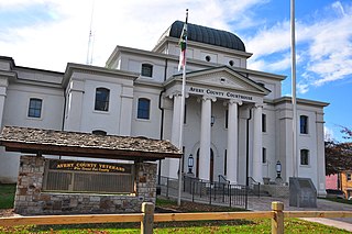
Avery County is a county located in the U.S. state of North Carolina. As of the 2020 census, the population was 17,806. The county seat is Newland. The county seat was initially established in Elk Park when the county was first formed, but was moved to Newland upon completion of the courthouse in 1912. Founded in 1911, it is the youngest of North Carolina's 100 counties.

<span class="mw-page-title-main">Bakersville, North Carolina</span> Town in North Carolina, United States

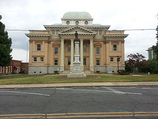
Bakersville is a town in Mitchell County, North Carolina, United States. The population was 464 at the 2010 census. It is the county seat of Mitchell County.

<span class="mw-page-title-main">Spruce Pine, North Carolina</span> Town in North Carolina, United States

Spruce Pine is the largest town in Mitchell County, North Carolina, United States. The population was 2,175 at the 2010 census.

<span class="mw-page-title-main">Burnsville, North Carolina</span> Town in North Carolina, United States

Burnsville is a town that serves as the county seat of Yancey County, North Carolina, United States. Located in the Blue Ridge Mountains of western North Carolina, sits in the shadow of Mount Mitchell, the highest peak in the Eastern Continental United States. The population was 1,612 at the 2020 census.

<span class="mw-page-title-main">North Carolina Highway 226</span> State highway in North Carolina, US

North Carolina Highway 226 (NC 226) is a primary state highway in the U.S. state of North Carolina. Traveling north–south through Western North Carolina, it connects the cities and towns of Grover, Shelby, Marion, Spruce Pine and Bakersville. It also a scenic byway in the South Mountains area and connects with the summer colony of Little Switzerland, via NC 226A.

<span class="mw-page-title-main">Western North Carolina</span> Geographic region of the U.S. state of North Carolina

Western North Carolina is the region of North Carolina which includes the Appalachian Mountains; it is often known geographically as the state's Mountain Region. It contains the highest mountains in the Eastern United States, with 125 peaks rising to over 5,000 feet in elevation. Mount Mitchell at 6,684 feet, is the highest peak of the Appalachian Mountains and mainland eastern North America. The population of the 23 most commonly associated counties for the region, as measured by the 2020 U.S. Census, is 1,149,405. The region accounts for approximately 11% of North Carolina's total population.

Three Mile is an unincorporated community in Avery County, North Carolina, United States. The community is located along NC 194 ; the name is derived from the air miles-straight-line distance of three miles between US 19-E to US 221.

<span class="mw-page-title-main">North Carolina Highway 80</span> State highway in North Carolina, US

North Carolina Highway 80 (NC 80) is a primary state highway in the U.S. state of North Carolina. The highway connects the various mountain communities straddled along Buck Creek, South Toe River and North Toe River in Western North Carolina and serves as a direct route, via the Blue Ridge Parkway, to Mount Mitchell State Park.

<span class="mw-page-title-main">North Carolina Highway 261</span> State highway in Mitchell County, North Carolina, US

North Carolina Highway 261 (NC 261) is a short state highway going from Bakersville to the Tennessee state line where the road turns into Tennessee State Route 143 (SR 143). The road is only 12.8 miles (20.6 km) long and is very curvy. The road is close to Roan Mountain State Park in Tennessee.

References

  1. Gannett, Henry (1905). The Origin of Certain Place Names in the United States. U.S. Government Printing Office. p.  210.
  2. 1 2 3 "QuickFacts: Mitchell County, North Carolina". United States Census Bureau. Retrieved March 21, 2024.
  3. "Find a County". National Association of Counties. Retrieved June 7, 2011.
  4. Mims, Bryan (March 31, 2014). "Exploring the Spruce Pine Mining District". Our State. Retrieved September 9, 2023.
  5. "Roan Mountain State Park". Hiking In The Smokys. Retrieved September 9, 2023.
  6. Mitchell News-Journal (July 26, 2023). "Pair of annual gem shows return to area". Mitchell News-Journal. Retrieved September 9, 2023.
  7. "North Carolina Rhododendron Festival". RomanticAsheville.com. Retrieved September 9, 2023.
  8. "Negro Laborers Not Allowed There; Railroad Company Wants Protection". The Dayton Evening Herald . Dayton, Ohio. November 6, 1899. p. 5 via Newspapers.com. The Ohio River & Charleston Railroad Co. will appeal to Governor Russell for protection for its gangs of negro laborers in Mitchell county. The residents of this county escorted three gangs of laborers to the border line and told them not to return under pain of death. It is the boast of the people of Mitchell county that no negroes are allowed to live or work there. Up to date the boast has been made good. The situation is serious, and blood may flow if the railroad company brings its colored laborers back.
  9. Neufeld, Rob. "Visiting Our Past: Feldspar mining and racial tensions". The Asheville Citizen Times. Retrieved March 26, 2021.
  10. Jaspin, Elliot (2007). Buried in the Bitter Waters: the Hidden History of Racial Cleansing in America. New York: Basic Books. pp. 201–217. ISBN   9780465036363.
  11. "2020 County Gazetteer Files – North Carolina". United States Census Bureau. August 23, 2022. Retrieved September 9, 2023.
  12. 1 2 "NCWRC Game Lands". www.ncpaws.org. Retrieved March 30, 2023.
  13. Igelman, Jack (January 3, 2022). "The struggle over protecting the Nolichucky River". Carolina Public Press. Retrieved July 10, 2023.
  14. "U.S. Decennial Census". United States Census Bureau. Retrieved January 18, 2015.
  15. "Historical Census Browser". University of Virginia Library. Retrieved January 18, 2015.
  16. Forstall, Richard L., ed. (March 27, 1995). "Population of Counties by Decennial Census: 1900 to 1990". United States Census Bureau. Retrieved January 18, 2015.
  17. "Census 2000 PHC-T-4. Ranking Tables for Counties: 1990 and 2000" (PDF). United States Census Bureau. April 2, 2001. Archived (PDF) from the original on March 27, 2010. Retrieved January 18, 2015.
  18. "State & County QuickFacts". United States Census Bureau. Archived from the original on June 6, 2011. Retrieved October 27, 2013.
  19. "Explore Census Data". data.census.gov. Retrieved December 19, 2021.
  20. "U.S. Census website". United States Census Bureau . Retrieved January 31, 2008.
  21. Bureau, U.S. Census. "American FactFinder - Results". factfinder.census.gov. Archived from the original on February 13, 2020. Retrieved March 16, 2018.
  22. Gong, Phillip Joonbae (October 26, 2022). "Who are North Carolina's Republican Voters? A 2022 Update". Carolina Demography. University of North Carolina at Chapel Hill. Retrieved December 18, 2022.
  23. Leip, David. "Dave Leip's Atlas of U.S. Presidential Elections". uselectionatlas.org. Retrieved March 16, 2018.
  24. "North Carolina Primary Election Results 2016". The New York Times. September 29, 2016. ISSN   0362-4331 . Retrieved March 16, 2018.
  25. "North Carolina Election Results 2016". The New York Times. August 1, 2017. ISSN   0362-4331 . Retrieved March 16, 2018.
  26. "Economic Incentives". Mitchell County Economic Development Commission. Retrieved February 27, 2024.
  27. "Quarterly Census of Employment and Wages (QCEW) Largest Employers". Demand Driven Data Delivery. 2022. Retrieved July 13, 2023.
  28. "Greenlee Primary School". sites.google.com. Retrieved August 8, 2022.
  29. "DES". sites.google.com. Retrieved August 8, 2022.
  30. "Harris Middle School". sites.google.com. Retrieved August 8, 2022.
  31. "Gouge Elementary". sites.google.com. Retrieved August 8, 2022.
  32. "Bowman Middle School". sites.google.com. Retrieved August 8, 2022.
  33. "About Mayland - Mayland". April 9, 2018. Retrieved August 8, 2022.
  34. "Studios". Penland School of Craft. November 26, 2016. Retrieved August 8, 2022.
  35. "Mission". Penland School of Craft. November 26, 2016. Retrieved August 8, 2022.
  36. "mitchellnews.com/about". www.mitchellnews.com. August 7, 2022.
  37. "Mitchell". WKYK, WTOE. Retrieved August 8, 2022.