Bakersville, North Carolina

Last updated

Bakersville, North Carolina
Bakersville, NC.JPG
North Mitchell Ave in downtown Bakersville
Bakersville, NC Town Seal.jpg
Motto(s): 
"Gateway to the Roan, Home to the Arts"
NCMap-doton-Bakersville.PNG
Location of Bakersville, North Carolina
Coordinates: 36°00′55″N82°09′30″W / 36.01528°N 82.15833°W / 36.01528; -82.15833
Country United States
State North Carolina
County Mitchell
Incorporated1868 [1]
Named for David Baker [1]
Area
[2]
  Total0.76 sq mi (1.97 km2)
  Land0.76 sq mi (1.97 km2)
  Water0.00 sq mi (0.00 km2)
Elevation
[3]
2,464 ft (751 m)
Population
 (2020)
  Total450
  Density592.11/sq mi (228.58/km2)
Time zone UTC-5 (Eastern (EST))
  Summer (DST) UTC-4 (EDT)
ZIP code
28705
Area code 828
FIPS code 37-03100 [4]
GNIS feature ID2405201 [3]
Website www.bakersville.com

Bakersville is a town in Mitchell County, North Carolina, United States. The population was 464 at the 2010 census. It is the county seat of Mitchell County. [5]

Contents

History

In prehistoric times, local mica deposits were extensively mined by Native Americans. The first Euro-American settlers arrived in the area after the American Revolution, establishing scattered homesteads. The town of Bakersville dates from the 1850s [6] and was named for David Baker, a Revolutionary War soldier and one of the first to live in the area around 1790 and described as "a large land owner, innkeeper, merchant and political leader until his death in 1838. Some of David's sons and daughters remained and were equally influential in the area for many years after David's death. " [7] Situated on the main route leading over Roan Mountain and westward into Tennessee, the town developed slowly. Traveler Frederick Law Olmsted passed through Bakersville in the early 1850s and noted that the "town" consisted of only a couple of cabins within a quarter-mile radius. [6] In 1861, a post office was established and named Davis after Jefferson Davis. [7] Following the Civil War, the county seat of newly created Mitchell County was relocated to the town that had been renamed Bakersville by the Republican state government, [7] [6] leading to the construction of a courthouse and a growth in population. In the 1870s, as mica became commercially valuable, the rich local deposits of the mineral caused a temporary economic boom. [6] Bakersville is also home to the North Carolina Rhododendron Festival. The pageant attracts visitors from across the state and nation, most notably Richard Nixon in 1968.

Historian and sociologist James W. Loewen has identified Bakersville as one of several possible sundown towns in North Carolina. [8]

The Mitchell County Courthouse was added to the National Register of Historic Places in 1979. [9]

Geography

According to the United States Census Bureau, the town has a total area of 0.8 square miles (2.1 km2), all land.

Education

Bakersville has one public primary and middle school, with approximately two hundred students.

Demographics

Historical population
CensusPop.Note
1900 511
1910 416−18.6%
1920 332−20.2%
1930 42628.3%
1940 4372.6%
1950 428−2.1%
1960 393−8.2%
1970 4094.1%
1980 373−8.8%
1990 332−11.0%
2000 3577.5%
2010 46430.0%
2020 450−3.0%
U.S. Decennial Census [10]

As of the census [4] of 2000, there were 357 people, 168 households, and 97 families residing in the town. The population density was 474.4 inhabitants per square mile (183.2/km2). There were 206 housing units at an average density of 273.8 per square mile (105.7/km2). The racial makeup of the town was 99.72% White and 0.28% Native American. Hispanic or Latino of any race were 0.28% of the population.

There were 168 households, out of which 20.2% had children under the age of 18 living with them, 45.2% were married couples living together, 12.5% had a female householder with no husband present, and 41.7% were non-families. 39.3% of all households were made up of individuals, and 22.6% had someone living alone who was 65 years of age or older. The average household size was 2.04 and the average family size was 2.72.

In the town, the population was spread out, with 19.3% under the age of 18, 8.1% from 18 to 24, 20.4% from 25 to 44, 26.1% from 45 to 64, and 26.1% who were 65 years of age or older. The median age was 46 years. For every 100 females, there were 77.6 males. For every 100 females age 18 and over, there were 76.7 males.

The median income for a household in the town was $19,286, and the median income for a family was $31,563. Males had a median income of $27,500 versus $22,083 for females. The per capita income for the town was $15,997. About 15.2% of families and 18.2% of the population were below the poverty line, including 16.9% of those under age 18 and 23.7% of those age 65 or over.

Educational facilities

Bakersville is home to Gouge Primary School (K–4), Bowman Middle School (5–8), and Mitchell High School (9-12).

The Mitchell County Library, a branch of the Avery-Mitchell-Yancey Regional Library, is located at 18 North Mitchell Avenue.

Notable people

See also

Related Research Articles

<span class="mw-page-title-main">Unicoi County, Tennessee</span> County in Tennessee, United States

Unicoi County is a county located in the U.S. state of Tennessee. As of the 2020 census, the population was 17,928. Its county seat is Erwin. Unicoi is a Cherokee word meaning "white," "hazy," "fog-like," or "fog draped," and refers to the mist often seen in the foothills and mountains of this far northeast county. Unicoi County is part of the Johnson City Metropolitan Statistical Area, which is a component of the Johnson City–Kingsport–Bristol, TN-VA Combined Statistical Area, commonly known as the "Tri-Cities" region.

<span class="mw-page-title-main">Overton County, Tennessee</span> County in Tennessee, United States

Overton County is a county located in the U.S. state of Tennessee. As of the 2020 census, the population was 22,511. Its county seat is Livingston. Overton County is part of the Cookeville, TN Micropolitan Statistical Area.

<span class="mw-page-title-main">Carter County, Tennessee</span> County in Tennessee, United States

Carter County is a county located in the U.S. state of Tennessee. As of the 2020 census, the population was 56,356. Its county seat is Elizabethton. The county is named in honor of Landon Carter (1760–1800), an early settler active in the "Lost State of Franklin" 1784-1788 secession from the State of North Carolina. Carter County is part of the Johnson City, TN Metropolitan Statistical Area, which is a component of the Johnson City–Kingsport–Bristol, TN-VA Combined Statistical Area, located in northeastern Tennessee.

<span class="mw-page-title-main">Yancey County, North Carolina</span> County in North Carolina, United States

Yancey County is a county located in the U.S. state of North Carolina. As of the 2020 census, the population was 18,470. Its county seat is Burnsville.

<span class="mw-page-title-main">Swain County, North Carolina</span> County in North Carolina, United States

Swain County is a county located on the far western border of the U.S. state of North Carolina. As of the 2020 census, the population was 14,117. Its county seat is Bryson City.

<span class="mw-page-title-main">Mitchell County, North Carolina</span> County in North Carolina, United States

Mitchell County is a county located in the U.S. state of North Carolina. As of the 2020 census, the population was 14,903. Its county seat is Bakersville.

<span class="mw-page-title-main">Arab, Alabama</span> City in Alabama, United States

Arab is a city in Marshall County in the northern part of the U.S. state of Alabama, located 10 miles (16 km) from Guntersville Lake and Guntersville Dam, and is included in the Huntsville-Decatur Combined Statistical Area. The population was 8,461 at the 2020 census.

<span class="mw-page-title-main">Denning, New York</span> Town in New York, United States

Denning is an isolated town in Ulster County, New York, United States. The population was 493 at the 2020 census. The town is named after an early landowner, William Denning. Denning is located in the western part of the county, deep inside the Catskill Mountains. The location of the town in the Catskill State Park accounts in part for its low population.

<span class="mw-page-title-main">Newland, North Carolina</span> Town in North Carolina, United States

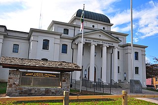
Newland is a town in Avery County, North Carolina, United States. The population was 698 at the 2010 census. It is the county seat of Avery County.

<span class="mw-page-title-main">Valdese, North Carolina</span> Town in North Carolina, United States

Valdese is a town in Burke County, North Carolina, United States. The population was 4,689 at the 2020 census. It is part of the Hickory-Lenoir-Morganton Metropolitan Statistical Area. One of the largest Waldensian congregations in the United States was founded in the town in the late nineteenth century, now known as the Waldensian Presbyterian Church. The town was settled by immigrants from the Cottian Alps in the Piedmont region of Italy.

<span class="mw-page-title-main">Maggie Valley, North Carolina</span> Town in North Carolina, United States

Maggie Valley is a town in Haywood County, North Carolina, United States. The population was 1,687 at the 2020 census. A popular tourist destination, it is home to Cataloochee Ski Area and the former Ghost Town in the Sky amusement park. Maggie Valley is part of the Asheville metropolitan area.

<span class="mw-page-title-main">Spruce Pine, North Carolina</span> Town in North Carolina, United States

Spruce Pine is the largest town in Mitchell County, North Carolina, United States. The population was 2,175 at the 2010 census.

<span class="mw-page-title-main">Faith, North Carolina</span> Town in North Carolina, United States

Faith is a town in Rowan County, North Carolina, United States, incorporated in 1903. The population was 807 at the 2010 census.

<span class="mw-page-title-main">Bryson City, North Carolina</span> Town in North Carolina, United States

Bryson City is a town in and the county seat of Swain County, North Carolina, United States. The population was 1,558 as of the 2020 census. Located in what was historically the land of the Cherokee, Bryson City was founded as Charleston to serve as the county seat of Swain County when it was formed from parts of surrounding counties. It grew into an important local rail hub. Today the city serves as a popular tourist destination, lying just to the west of the entrance to the Great Smoky Mountains National Park, for outdoor activities in the Nantahala National Forest, and along the Nantahala River and Fontana Lake, and serves as the home of the Great Smoky Mountains Railroad, a heritage railroad that provides tours of the Nantahala valley. The popular Nantahala Outdoor Center provides guide services for many of the outdoor activities in the area.

<span class="mw-page-title-main">Burnsville, North Carolina</span> Town in North Carolina, United States

Burnsville is a town that serves as the county seat of Yancey County, North Carolina, United States. Located in the Blue Ridge Mountains of western North Carolina, sits in the shadow of Mount Mitchell, the highest peak in the Eastern Continental United States. The population was 1,612 at the 2020 census.

<span class="mw-page-title-main">Roan Mountain, Tennessee</span> CDP in Tennessee, United States

Roan Mountain is a census-designated place (CDP) in Carter County, Tennessee, United States. The population was 1,360 at the 2010 census. It is part of the Johnson City Metropolitan Statistical Area, which is a component of the Johnson City–Kingsport–Bristol, TN-VA Combined Statistical Area – commonly known as the Tri-Cities region.

<span class="mw-page-title-main">Signal Mountain, Tennessee</span> Town in Tennessee, United States

Signal Mountain is a town in Hamilton County, Tennessee, United States. The town is a suburb of Chattanooga and is located on Walden Ridge. "Signal Mountain" is used as a colloquial name for the part of Walden Ridge close to the town. The town population was 8,852 as of the 2020 census and estimated to be 8,567 in 2018.

<span class="mw-page-title-main">Sneedville, Tennessee</span> City in Tennessee, United States

Sneedville is the only city in and the county seat of Hancock County, Tennessee, United States. The population was 1,282 per the 2020 census.

<span class="mw-page-title-main">Mountain City, Tennessee</span> Town in Tennessee, United States

Mountain City is a town in and the county seat of Johnson County, Tennessee, United States. The population was 2,415 at the 2020 census. It is the northeasternmost county seat in Tennessee. In addition, at an elevation of 2,418 feet (737 m), it has the distinction of being the highest incorporated city in the state.

<span class="mw-page-title-main">Erwin, Tennessee</span> Town in Tennessee, United States

Erwin is a town in and the county seat of Unicoi County, Tennessee, United States. The population was 6,097 at the 2010 census. It is part of the Johnson City metropolitan area, which is a component of the "Tri-Cities" region.

References

  1. 1 2 "North Carolina Gazetteer" . Retrieved December 26, 2020.
  2. "ArcGIS REST Services Directory". United States Census Bureau. Retrieved September 20, 2022.
  3. 1 2 U.S. Geological Survey Geographic Names Information System: Bakersville, North Carolina
  4. 1 2 "U.S. Census website". United States Census Bureau . Retrieved January 31, 2008.
  5. "Find a County". National Association of Counties. Archived from the original on May 31, 2011. Retrieved June 7, 2011.
  6. 1 2 3 4 Kevin W. Young, "Following in Ancient Footsteps: The Birth of the Mica Industry in Bakersville, North Carolina." Now & Then: The Appalachian Magazine (Summer 2013), pp. 30-31.
  7. 1 2 3 Neufeld, Rob (April 16, 2017). "Visiting Our Past: Mitchell mill sifts through 150 years". Asheville Citizen-Times . Retrieved April 17, 2017.
  8. "Possible Sundown Towns in NC". sundown.tougaloo.edu. Archived from the original on April 28, 2018. Retrieved March 6, 2021.
  9. "National Register Information System". National Register of Historic Places . National Park Service. July 9, 2010.
  10. "Census of Population and Housing". Census.gov. Retrieved June 4, 2015.
  11. Thompson, Richard. (November 6, 2013). Del McCoury Highway dedicated in NC. Bluegrass Today. Retrieved December 16, 2020.
  12. Hayes, Hank. (February 8, 2015). Colleagues remember late state representative. timenews.net. Retrieved December 16, 2020.