Trenton, North Carolina

Last updated

Trenton, North Carolina
Trenton, NC.jpg
Downtown Trenton
Trenton, NC Town Seal.webp
NCMap-doton-Trenton.PNG
Location of Trenton, North Carolina
Coordinates: 35°03′49″N77°21′19″W / 35.06361°N 77.35528°W / 35.06361; -77.35528
Country United States
State North Carolina
County Jones
Area
[1]
  Total0.25 sq mi (0.64 km2)
  Land0.24 sq mi (0.63 km2)
  Water0.00 sq mi (0.00 km2)
Elevation
[2]
26 ft (8 m)
Population
 (2020)
  Total238
  Density975.41/sq mi (377.32/km2)
Time zone UTC-5 (Eastern (EST))
  Summer (DST) UTC-4 (EDT)
ZIP code
28585
Area code 252
FIPS code 37-68320 [3]
GNIS feature ID2406751 [2]
Website townoftrenton.com

Trenton is a town in Jones County, North Carolina, United States. The population was 238 in 2020 census. It is the county seat of Jones County. [4]

Contents

Trenton is part of the New Bern, North Carolina Micropolitan Statistical Area.

History

Grace Episcopal Church and the Trenton Historic District are listed on the National Register of Historic Places. [5]

Geography

According to the United States Census Bureau, the town has a total area of 0.2 square miles (0.52 km2), all land.

Demographics

Historical population
CensusPop.Note
1810 98
1880 149
1890 20738.9%
1900 33863.3%
1910 331−2.1%
1920 48847.4%
1930 5002.5%
1940 431−13.8%
1950 4698.8%
1960 404−13.9%
1970 53933.4%
1980 294−45.5%
1990 248−15.6%
2000 206−16.9%
2010 28739.3%
2020 238−17.1%
U.S. Decennial Census [6]

2020 census

Trenton racial composition [7]
RaceNumberPercentage
White (non-Hispanic)11548.32%
Black or African American (non-Hispanic)7933.19%
Native American 31.26%
Asian 62.52%
Other/Mixed 2410.08%
Hispanic or Latino 114.62%

As of the 2020 United States census, there were 238 people, 119 households, and 86 families residing in the town.

2000 census

As of the census [3] of 2000, there were 206 people, 95 households, and 66 families residing in the town. The population density was 1,075.0 inhabitants per square mile (415.1/km2). There were 125 housing units at an average density of 652.3 per square mile (251.9/km2). The racial makeup of the town was 69.90% White, 26.70% African American, 0.97% Asian, 0.49% Pacific Islander, 1.46% from other races, and 0.49% from two or more races. Hispanic or Latino of any race were 1.46% of the population.

There were 95 households, out of which 23.2% had children under the age of 18 living with them, 49.5% were married couples living together, 12.6% had a female householder with no husband present, and 29.5% were non-families. 26.3% of all households were made up of individuals, and 13.7% had someone living alone who was 65 years of age or older. The average household size was 2.13 and the average family size was 2.51.

In the town, the population was spread out, with 20.4% under the age of 18, 5.3% from 18 to 24, 22.3% from 25 to 44, 26.7% from 45 to 64, and 25.2% who were 65 years of age or older. The median age was 46 years. For every 100 females, there were 110.2 males. For every 100 females age 18 and over, there were 97.6 males.

The median income for a household in the town was $35,833, and the median income for a family was $40,156. Males had a median income of $26,750 versus $20,625 for females. The per capita income for the town was $14,774. About 18.8% of families and 20.2% of the population were below the poverty line, including 34.4% of those under the age of eighteen and 9.8% of those 65 or over.

Related Research Articles

<span class="mw-page-title-main">Eagle Lake, Maine</span> Town in the state of Maine, United States

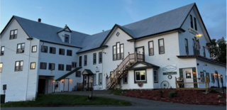
Eagle Lake is a town in Aroostook County, Maine, United States. The population was 772 at the 2020 census. The town was named by a body of troops heading from Bangor to the Aroostook War for the many eagles that they saw around the lake. A total of 49.0% of the population speaks French, reflecting a trend in Northeastern Maine.

<span class="mw-page-title-main">Island Falls, Maine</span> Town in the state of Maine, United States

Island Falls is a town in Aroostook County, Maine, United States. The population was 758 at the 2020 census. The primary village of Island Falls in the town is situated at a falls in the West Branch Mattawamkeag River.

<span class="mw-page-title-main">Mapleton, Maine</span> Town in the state of Maine, United States

Mapleton is a town in Aroostook County, Maine, United States. The population was 1,886 at the 2020 census.

<span class="mw-page-title-main">Perham, Maine</span> Town in the state of Maine, United States

Perham is a town in Aroostook County, Maine, United States. The population was 371 at the 2020 census. The town was named after Maine's 33rd governor, Sidney Perham.

<span class="mw-page-title-main">Trenton, Maine</span> Town in the state of Maine, United States

Trenton is a town in Hancock County, Maine, United States, near Acadia National Park. The population was 1,584 at the 2020 census. Hancock County-Bar Harbor Airport is located in Trenton.

<span class="mw-page-title-main">Verona Island, Maine</span> Town in Maine, United States

Verona Island is a town located on an island of the same name in the Penobscot River in Hancock County, Maine, United States. The population was 507 at the 2020 census.

<span class="mw-page-title-main">Ong, Nebraska</span> Village in Nebraska, United States

Ong is a village in Clay County, Nebraska, United States. The population was 49 at the 2020 census. It is part of the Hastings, Nebraska Micropolitan Statistical Area.

<span class="mw-page-title-main">Trenton, Nebraska</span> Village in Hitchcock County, Nebraska, United States

Trenton is a village in Hitchcock County, Nebraska, United States. The population was 516 at the 2020 census. It is the county seat of Hitchcock County.

<span class="mw-page-title-main">Stuart, Nebraska</span> Village in Nebraska, United States

Stuart is a village in Holt County, Nebraska, United States. The population was 590 at the 2010 census.

<span class="mw-page-title-main">White Lake, North Carolina</span> Town in North Carolina, United States

White Lake is a town in Bladen County, North Carolina, United States. The population was 802 at the 2010 census, up from 529 in 2000.

<span class="mw-page-title-main">Fairfax, South Carolina</span> Town in South Carolina, United States

Fairfax is a town in Allendale and Hampton counties, South Carolina, United States. The population was 2,025 at the 2010 census, a decline of over one-third of its population of 3,206 from 2000.

<span class="mw-page-title-main">Govan, South Carolina</span> Town in South Carolina, United States

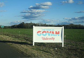
Govan is a town in Bamberg County, South Carolina, United States. The population was 65 at the 2010 census.

<span class="mw-page-title-main">Hilda, South Carolina</span> Town in South Carolina, United States

Hilda is a town in Barnwell County, South Carolina, United States. The population was 447 at the 2010 census..

<span class="mw-page-title-main">Kline, South Carolina</span> Town in South Carolina, United States

Kline is a town in Barnwell County, South Carolina, United States. The population was 197 at the 2010 census.

<span class="mw-page-title-main">Trenton, South Carolina</span> Town in South Carolina, United States

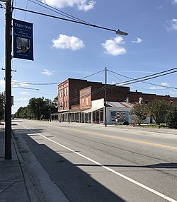
Trenton is a town in Edgefield County, South Carolina, United States. The population was 196 at the 2010 census, down from 226 in 2000.

<span class="mw-page-title-main">Davis, South Dakota</span> Town in South Dakota, United States

Davis is a town in Turner County, South Dakota, United States. The population was 54 at the 2020 census.

<span class="mw-page-title-main">Virgilina, Virginia</span> Town in Virginia, United States

Virgilina is a town in Halifax County, Virginia, United States. The population was 154 at the 2010 census. Virgilina was once a copper mining town. It was a stop on the Atlantic and Danville Railway as recently as the 1950s. It is named "Virgilina" because it is located on the Virginia and North Carolina border.

<span class="mw-page-title-main">Trenton, Dodge County, Wisconsin</span> Town in Wisconsin, United States

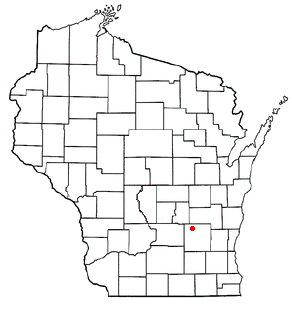
Trenton is a town in Dodge County, Wisconsin, United States. The population was 1,301 at the 2000 census.

<span class="mw-page-title-main">Weddington, North Carolina</span> Town in North Carolina, United States

Weddington is a suburban town in Union County, North Carolina, United States. The population was 9,459 at the 2010 census. It is a suburb in the Charlotte metropolitan area. The current mayor of Weddington is Jim Bell.

Fremont is a town in Waupaca County, Wisconsin, United States. The population was 632 at the 2000 census. The village of Fremont is located within the town. The unincorporated community of Red Banks is located in the town.

References

  1. "ArcGIS REST Services Directory". United States Census Bureau. Retrieved September 20, 2022.
  2. 1 2 U.S. Geological Survey Geographic Names Information System: Trenton, North Carolina
  3. 1 2 "U.S. Census website". United States Census Bureau . Retrieved January 31, 2008.
  4. "Find a County". National Association of Counties. Retrieved June 7, 2011.
  5. "National Register Information System". National Register of Historic Places . National Park Service. July 9, 2010.
  6. "Census of Population and Housing". Census.gov. Retrieved June 4, 2015.
  7. "Explore Census Data". data.census.gov. Retrieved December 24, 2021.