Rockingham, North Carolina

Last updated

Rockingham, North Carolina
Rockingham mc downtown.jpg
City Square - Downtown Rockingham
Rockingham, NC City Seal.webp
Motto: 
"A City Looking Forward"
USA North Carolina location map.svg
Red pog.svg
Rockingham, North Carolina
Location within the state of North Carolina
Coordinates: 34°56′19″N79°45′39″W / 34.93861°N 79.76083°W / 34.93861; -79.76083
Country United States
State North Carolina
County Richmond
Incorporated1784
Area
[1]
  Total7.65 sq mi (19.82 km2)
  Land7.64 sq mi (19.80 km2)
  Water0.01 sq mi (0.03 km2)
Elevation
[2]
266 ft (81 m)
Population
 (2020)
  Total9,243
  Density1,209.34/sq mi (466.93/km2)
Time zone UTC-5 (Eastern (EST))
  Summer (DST) UTC-4 (EDT)
ZIP codes
28379-28380
Area codes 910, 472
FIPS code 37-57260 [3]
GNIS feature ID2404637 [2]
Website www.gorockingham.com

Rockingham is a city in Richmond County, North Carolina, United States, named after the Marquess of Rockingham. The population was 9,558 at the 2010 census. It is the county seat of Richmond County. [4]

Contents

Downtown Rockingham is currently being revitalized as a part of a ten-year plan named "Shaping Our Future: 2023". [5] The city is currently experiencing an economic boom, with new businesses opening in the downtown area. [6]

History

The city was named for Charles Watson-Wentworth, 2nd Marquess of Rockingham, British Prime Minister from 1765 to 1766 and again in 1782. Rockingham's administration was dominated by the issue of the Thirteen Colonies. Rockingham wanted to repeal the Stamp Act 1765 and won a Commons vote in 1766 on the repeal resolution by 275 to 167. [7] As a result, he was a popular figure among British colonists in America (who would later become known simply as "Americans"). People in North Carolina were still sympathetic toward him in the years following the United States gaining independence.

During the early 19th century, numerous families from here migrated to Middle Tennessee, settling in what is now Nolensville. They quickly established their new community.

In 1950, the town fielded a professional minor league baseball team in the Class D Tobacco State League, the Rockingham Eagles. The club won the playoff title in their only season before disbanding with the entire league. [8]

Rockingham has a number of historic buildings which have been listed on the National Register of Historic Places since the late 1970s: the Bank of Pee Dee Building, Covington Plantation House, Alfred Dockery House, Hannah Pickett Mill No. 1, Manufacturers Building, Richmond County Courthouse, Roberdel Mill No. 1 Company Store, Rockingham Historic District, U.S. Post Office and Federal Building, and H. C. Watson House. [9]

Geography

Rockingham is situated in the south-central North Carolina Piedmont. It is located 61 miles (98 km) west of Lumberton, 61 miles (98 km) north of Florence, 70 miles (110 km) east of Charlotte, and 83 miles (134 km) south of Greensboro. According to the United States Census Bureau, the city has a total area of 7.3 square miles (19 km2), of which 7.3 square miles (18.9 km2) is land and 0.04 square miles (0.10 km2) (0.41%) is water.

Rockingham's unincorporated suburbs within Richmond County that reside just outside the Rockingham-Hamlet statistical area: Cordova, East Rockingham, Dobbins Heights, Hoffman.

Urban

The Midtown business district is densely populated with stores, boutiques, clothing stores and several apartment complexes just outside the area. While not as urban as many cities in North Carolina, it is considered by the census as the urbanized area for Rockingham and Richmond County.

Neighborhoods

The Rockingham area is divided into various neighborhoods and suburbs; many include different socioeconomic classes. These include Cordova, Philadelphia, Ledbetter, Roberdell, East Rockingham, West Rockingham, Glenwood, Maplewood, East Side Park, and Knob Hill. [10]

Demographics

Historical population
CensusPop.Note
1870 454
1900 1,507
1910 2,15543.0%
1920 2,50916.4%
1930 2,90615.8%
1940 3,65725.8%
1950 3,356−8.2%
1960 5,51264.2%
1970 5,8526.2%
1980 8,30041.8%
1990 9,39913.2%
2000 9,6722.9%
2010 9,558−1.2%
2020 9,243−3.3%
U.S. Decennial Census [11]

As of the 2018 estimates, the area is a part of the Hamlet-Rockingham micropolitan statistical area and has a population of 22,579. The area will eventually be served by I-73/I-74, which will go west of the city. The area has many hotels, in part because beach traffic comes through this city.

2020 census

Rockingham racial composition [12]
RaceNumberPercentage
White (non-Hispanic)4,66850.5%
Black or African American (non-Hispanic)3,27435.42%
Native American 1811.96%
Asian 1311.42%
Pacific Islander 20.02%
Other/Mixed 4534.9%
Hispanic or Latino 5345.78%

As of the 2020 United States census, there were 9,243 people, 3,602 households, and 2,211 families residing in the city.

2010 census

As of the 2010 census, [3] there were 9,553 people, 3,966 households, and 2,573 families residing in the city. The population density was 1,326.8 inhabitants per square mile (512.3/km2). There were 4,375 housing units at an average density of 600.1 per square mile (231.7/km2). The racial makeup of the city was 65.57% White, 29.90% African American, 1.10% Native American, 1.34% Asian, 0.06% Pacific Islander, 0.81% from other races, and 1.22% from two or more races. Hispanic or Latino of any race were 2.10% of the population.

There were 3,966 households, out of which 30.7% had children under the age of 18 living with them, 41.8% were married couples living together, 19.4% had a female householder with no husband present, and 35.1% were non-families. 32.1% of all households were made up of individuals, and 14.6% had someone living alone who was 65 years of age or older. The average household size was 2.33 and the average family size was 2.92.

In the city, 25.8% of the population was under the age of 18, 7.9% from 18 to 24, 27.2% from 25 to 44, 21.6% from 45 to 64, and 17.5% who were 65 years of age or older. The median age was 37 years. For every 100 females, there were 82.7 males. For every 100 females age 18 and over, there were 76.6 males.

The median income for a household in the city was $26,574, and the median income for a family was $33,534. Males had a median income of $27,923 versus $20,313 for females. The per capita income for the city was $15,426. About 18.0% of families and 20.4% of the population were below the poverty line, including 32.4% of those under age 18 and 15.0% of those age 65 or over.

Arts and culture

Museums

Events

Rockingham hosts "The Smokeout" (an annual motorcycle weekend), and has also hosted the Carolina Rebellion rock festival.

The city is the home of Rockingham Speedway, formerly the North Carolina Speedway. It was a staple of the NASCAR schedule for nearly 40 years before the race was discontinued in 2004.

Education

Rockingham operated its own school system until 1968, when it was absorbed by the Richmond County School System. [14]

The Leon Levine School of Business and Information Technology, part of Richmond Community College, is planned to be completed in downtown Rockingham, to offer post-graduate education to Rockingham. The building will be three stories tall, and is scheduled to be open for the 2020 fall semester. The school will offer programs including Accounting Specialist, IT Support — Healthcare, Healthcare Manager, Government Support Specialist, Cyber Security, Software and Web Developer, and Mobile Application Developer. The school will also provide classroom space for the college's Workforce and Economic Development division and Small Business Center. [15]

Richmond Senior High School serves as the high school for Richmond County residents.

Education in Rockingham is rated[ by whom? ] as "above average" and received a B rating. [16]

Rockingham also offers other education centers such as the Richmond Community College Main Campus.

A new three-story downtown Richmond Community College campus is being constructed and is expected to be open for the 2020 fall semester; it was originally planned to open in January, but got pushed back. [17] It is expected to draw new businesses and retailers. [18]

Media

Transportation

Air

Richmond County Airport (ICAO: KRCZ, FAA LID: RCZ), formerly known as Rockingham-Hamlet Airport, is located approximately 3 miles southeast of Rockingham. The airport serves local and transient general aviation flights.

Interstates and major highways

Notable people

Related Research Articles

<span class="mw-page-title-main">Rockingham County, Virginia</span> County in Virginia, United States

Rockingham County is a county located in the U.S. state of Virginia. As of the 2020 census, the population was 83,757. Its county seat is the independent city of Harrisonburg.

<span class="mw-page-title-main">Richmond County, North Carolina</span> County in North Carolina, United States

Richmond County is a county located on the central southern border of the U.S. state of North Carolina. Its county seat is Rockingham. The county was formed in 1779 from a portion of Anson County and named in honor of Charles Lennox, 3rd Duke of Richmond and Lennox. As of the 2020 census, the population was 42,946.

<span class="mw-page-title-main">Forsyth County, North Carolina</span> County in North Carolina, United States

Forsyth County is located in the northwest Piedmont of the U.S. state of North Carolina. As of the 2020 census, the population was 382,590, making it the fourth-most populous county in North Carolina. Its county seat is Winston-Salem. Forsyth County is part of the Winston-Salem, NC, Metropolitan Statistical Area, which is also included in the Greensboro–Winston-Salem–High Point, NC, Combined Statistical Area. Portions of Forsyth County are in the Yadkin Valley wine region.

<span class="mw-page-title-main">Richmond, Kentucky</span> City in Kentucky, United States

Richmond is a home rule-class city in and the county seat of Madison County, Kentucky, United States. It is named after Richmond, Virginia, and is home to Eastern Kentucky University. The population was 34,585 at the 2020 census. Richmond is the fourth-largest city in the Bluegrass region and the state's seventh-largest city. It is the ninth largest population center in the state with a Micropolitan population of 106,864. The city serves as the center for work and shopping for south-central Kentucky. In addition, Richmond is the principal city of the Richmond-Berea, Kentucky Micropolitan Area, which includes all of Madison and Rockcastle counties.

<span class="mw-page-title-main">Shelby, North Carolina</span> City in North Carolina, United States

Shelby is a city in and the county seat of Cleveland County, North Carolina. It lies near the western edge of the Charlotte-Concord, NC-SC Combined Statistical Area. The population was 21,918 at the 2020 census.

<span class="mw-page-title-main">Jamestown, North Carolina</span> Town in North Carolina, United States

Jamestown is a town in Guilford County, North Carolina, United States. It is a suburb of the nearby cities of Greensboro and High Point. The population was 3,382 at the 2010 census.

<span class="mw-page-title-main">Waynesville, North Carolina</span> Town in North Carolina, United States

Waynesville is the county seat of Haywood County, North Carolina. It is the largest town in North Carolina west of Asheville. Waynesville is located about 30 miles (50 km) southwest of Asheville between the Great Smoky and Blue Ridge Mountains.

<span class="mw-page-title-main">Hendersonville, North Carolina</span> City in North Carolina, United States

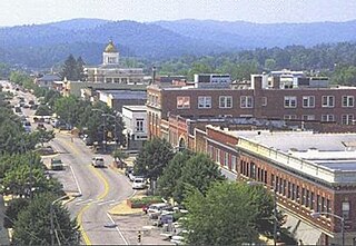
Hendersonville is a city in Henderson County, North Carolina, United States. It is 22 miles (35 km) south of Asheville and is the county seat of Henderson County. Like the county, the city is named for 19th-century North Carolina Supreme Court Chief Justice Leonard Henderson.

<span class="mw-page-title-main">Clayton, North Carolina</span> Town in North Carolina, United States

Clayton is a town in Johnston County, North Carolina, United States, and is considered a satellite town of Raleigh. As of 2010, Clayton's population was 16,116, up from 6,973 at the 2000 census. By 2019 the town's estimated population was 24,887. Much of that growth can be attributed to the town's proximity to the Research Triangle area and access to major highways such as I-40 and US 70.

<span class="mw-page-title-main">Ellerbe, North Carolina</span> Town in North Carolina, United States

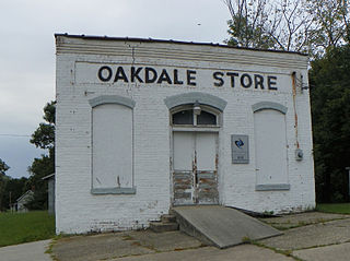
Ellerbe is a town in Richmond County, North Carolina, United States. The population was 1,054 at the 2010 census.

<span class="mw-page-title-main">Hamlet, North Carolina</span> City in North Carolina, United States

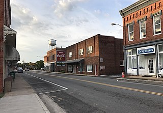
Hamlet is a city in Richmond County, North Carolina, United States. The population was 6,042 at the 2020 census.

<span class="mw-page-title-main">Eden, North Carolina</span> City in North Carolina, United States

Eden is a city in Rockingham County in the U.S. state of North Carolina and is part of the Greensboro-High Point Metropolitan Statistical Area of the Piedmont Triad metro region. As of the 2020 census, the population was 15,405. From the late nineteenth century through much of the 20th, the city was a center of textile mills and manufacturing. The city was incorporated in 1967 through the consolidation of three towns: Leaksville, Spray, and Draper.

<span class="mw-page-title-main">Reidsville, North Carolina</span> City in North Carolina, United States

Reidsville is a city in Rockingham County in the U.S. state of North Carolina. At the 2020 census, the city had a total population of 14,583. Reidsville is included in the Greensboro–High Point Metropolitan Statistical Area of the Piedmont Triad.

<span class="mw-page-title-main">Stoneville, North Carolina</span> Town in North Carolina, United States

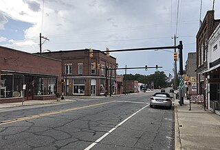
Stoneville is a town in Rockingham County, North Carolina, United States. Stoneville is part of the Greensboro–High Point metropolitan area of the Piedmont Triad. On March 20, 1998, an F-3 tornado touched down in neighboring Madison and Mayodan after the system had crossed into Rockingham County from Stokes County. Then, it strengthened into an F-3 as it crossed Route 220 as it followed the train tracks to downtown Stoneville.

<span class="mw-page-title-main">Wentworth, North Carolina</span> Town in North Carolina, United States

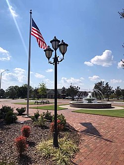
Wentworth is a town in Rockingham County, North Carolina, United States. The population was 2,646 at the 2020 census. Wentworth is the county seat of Rockingham County and is part of the Greensboro–High Point metropolitan area of the Piedmont Triad. On May 6, 2022, an EF-1 Tornado hit Wentworth. The storm traveled as a supercell with crazy structure from the Pilot Mountain, North Carolina, and Pinnacle, North Carolina, area across central Stokes County and into Rockingham County. It took out trees, damaged homes, and blocked roads before it lifted off southwest of Reidsville.

<span class="mw-page-title-main">Laurinburg, North Carolina</span> City in North Carolina, United States

Laurinburg is a city in and the county seat of Scotland County, North Carolina, United States. Located in southern North Carolina near the South Carolina border, Laurinburg is southwest of Fayetteville and is home to St. Andrews University. The population at the 2010 census was 15,962 people.

<span class="mw-page-title-main">Conway, South Carolina</span> City in South Carolina, United States

Conway is a city and the county seat of Horry County, South Carolina, United States. The population was 24,849 at the 2020 census, up from 17,103 in the 2010 census, making it the 18th-most populous city in the state. The city is part of the Myrtle Beach metropolitan area. It is the home of Coastal Carolina University.

<span class="mw-page-title-main">Richmond, Michigan</span> City in Michigan, United States

Richmond is a city within Metro Detroit in the U.S. state of Michigan. The population was 5,878 at the 2020 census. Most of the city is located in Macomb County, though there is a small portion in neighboring St. Clair County.

<span class="mw-page-title-main">Zebulon, North Carolina</span> Town in North Carolina, United States

Zebulon is the easternmost town in Wake County, North Carolina, United States. The population was 6,903 at the 2020 census. Zebulon is part of the Research Triangle metropolitan region. Five County Stadium, home to the Carolina Mudcats minor league baseball team, is located in the town. In May 2022, Zebulon was ranked North Carolina's second fastest growing town, only behind neighboring Wendell.

<span class="mw-page-title-main">Riverhead (CDP), New York</span> Hamlet and census-designated place in New York, United States

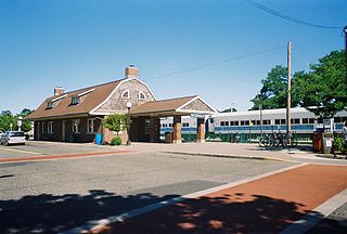
Riverhead is a census-designated place (CDP) roughly corresponding to the hamlet by the same name located in the Town of Riverhead in Suffolk County, on Long Island, in New York, United States. The CDP's population was 13,299 at the 2010 census.

References

  1. "ArcGIS REST Services Directory". United States Census Bureau. Retrieved September 20, 2022.
  2. 1 2 U.S. Geological Survey Geographic Names Information System: Rockingham, North Carolina
  3. 1 2 "U.S. Census website". United States Census Bureau . Retrieved January 31, 2008.
  4. "Find a County". National Association of Counties. Retrieved June 7, 2011.
  5. "Rockingham nears halfway mark on improvement plan". Richmond County Daily Journal. March 14, 2018. Retrieved May 10, 2020.
  6. "The Foundation of Growth: Building on downtown Rockingham's renaissance". Richmond County Daily Journal. November 28, 2019. Retrieved May 10, 2020.
  7. Ross J. S. Hoffman, The Marquis. A Study of Lord Rockingham, 1730–1782 (New York: Fordham University Press, 1973), p. 113.
  8. Holaday, Chris (2016). "The Tobacco State League; A North Carolina Baseball History, 1946–1950".. Jefferson, N.C.: McFarland. ISBN   978-1-4766-6670-9.
  9. "National Register Information System". National Register of Historic Places . National Park Service. July 9, 2010.
  10. "Rockingham, NC - 28330 - Demographics and Population Statistics - NeighborhoodScout". www.neighborhoodscout.com. Retrieved May 10, 2020.
  11. "Census of Population and Housing". Census.gov. Retrieved June 4, 2015.
  12. "Explore Census Data". data.census.gov. Retrieved December 22, 2021.
  13. "Discovery Place Kids-Rockingham". Discovery Place. Discovery Place. Retrieved July 2, 2021.
  14. Ruffin, Jane (December 9, 1991). "Tragedy in Hamlet : End of the Line : Dreams of Better Days". The News & Observer (final ed.). pp. 1A, 6A–8A.
  15. "RCC business school named for Leon Levine after $1M grant; building named for Robinettes". Richmond County Daily Journal. June 16, 2017. Retrieved May 10, 2020.
  16. "Living in Rockingham". Niche. Retrieved May 10, 2020.
  17. "Robinette Building almost complete". Richmond County Daily Journal. May 8, 2020. Retrieved May 10, 2020.
  18. "The Richmond Observer - Richmond County towns hoping for HGTV makeover". www.richmondobserver.com. Retrieved May 10, 2020.
  19. "Rockingham bypass to be a boon to business, officials say". Richmond County Daily Journal. November 12, 2019. Retrieved May 8, 2020.
  20. Lob, Christina. "Myrtle Beach leaders vow that I-73 remains a top priority". www.wmbfnews.com. Retrieved May 8, 2020.