Hayesville, North Carolina

Last updated

Hayesville, North Carolina
Downtown Hayesville, North Carolina, on July 7, 2023.jpg
Downtown Hayesville
NCMap-doton-Hayesville.PNG
Location of Hayesville, North Carolina
Coordinates: 35°02′42″N83°49′05″W / 35.04500°N 83.81806°W / 35.04500; -83.81806
CountryUnited States
State North Carolina
County Clay
Area
[1]
  Total0.64 sq mi (1.65 km2)
  Land0.64 sq mi (1.65 km2)
  Water0.00 sq mi (0.00 km2)
Elevation
[2]
1,890 ft (580 m)
Population
 (2020)
  Total461
  Density724.84/sq mi (279.84/km2)
Time zone UTC-5 (Eastern (EST))
  Summer (DST) UTC-4 (EDT)
ZIP code
28904
Area code 828
FIPS code 37-30280 [3]
GNIS feature ID2405807 [2]
Website www.townofhayesville.com

Hayesville is a town in Clay County, North Carolina, United States. The population was 311 at the 2010 census. It is the county seat of Clay County. [4]

Contents

History

The Clay County Courthouse on the Hayesville square is listed on the National Register of Historic Places The historic Clay County courthouse in downtown Hayesville, N.C. on July 10, 2022.jpg
The Clay County Courthouse on the Hayesville square is listed on the National Register of Historic Places

Quanassee

This was long an area of indigenous settlement along the Hiwassee River. An earthwork platform mound was built here, likely by people of the South Appalachian Mississippian culture about 1000 CE. It would have been the center of their village.

Later, the historic Cherokee developed a town known as Quanassee at this site. They built their townhouse on top of the mound, to provide a place for communal discussion and reaching consensus. It was one of the numerous "Valley Towns" located along the Hiwassee River in Western North Carolina. It was also along the Trading Path (also called the "Unicoi Turnpike"). That road led from Quanassee west to another town at present-day Murphy, North Carolina, then over the Unicoi Range at Unicoi Gap and down to the Cherokee town of Great Tellico (today Tellico Plains, Tennessee). [5]

Quanassee had several hundred inhabitants by 1550. In 1716, South Carolina officials met with Cherokee leaders in Quanassee to obtain the Cherokee's alliance in the Yamassee War. The next year South Carolina built a trading site in Quanassee to gain Cherokee commodities like deerskins in exchange for manufactured English goods. A Coosa (Creek) war party "cut off" Quanassee in 1725, demolishing the village and enslaving or killing most of its residents. The town was briefly reestablished before the American Revolution; Rutherford expedition forces camped there in 1776. In the 1820s, Baptist missionaries visited Quanassee to preach to families living there. [6]

Fort Hembree

In October 1837, Tennessee militia established Fort Hembree near Hayesville to prepare for deporting the Cherokee. [7] Approximately 1,000 Cherokee people were held prisoner at the fort and removed from the area. The military abandoned Fort Hembree in June 1838, though it was reactivated in 1860 to train soldiers for the Civil War. [8]

After the Cherokee were forced to cede their land, European Americans settled in this rural area and took over what is now known as the Spikebuck Town Mound and Village Site. They cultivated much of the village site, disturbing the topsoil layers. Some excavations were conducted in the 1960s and 1970s. [9] The town mound and village site was listed in 1982 on the National Register of Historic Places as an archeological site.

Clay County acquired the mound site in 2000 and protects it; the Archeological Conservancy acquired the town/village site and farmsteads in 2011. [9]

Hayesville founded

The town was named Hayesville after 19th-century politician George Hayes. [10] When running for representative from Cherokee County in the fall election of 1860, he learned that residents in the southeast end wanted to separate from Cherokee County and get their own county seat, because of the difficulty of traveling to the distant location. With the promise to introduce legislation to this effect, Hayes won a seat in the legislature. In February 1861 the legislation to organize a new county was introduced and passed by the North Carolina General Assembly. The county was named in honor of Kentucky statesman Henry Clay, and the county seat Hayesville, for Hayes. [11] :p.10 Though Hayesville was an active town since 1861 and town limits were set in 1882, it was not incorporated until March 12, 1913. [8] The first mayor was S.E. Hogsed.

Hayesville High School was founded in 1870 as Hicksville Academy. [12] In the 1890s it was bought by Duke University and offered college courses. [11] After the first wood-frame county courthouse in Hayesville was destroyed by arson in 1870, the brick courthouse currently standing on the town square was constructed in 1888. It is listed on the National Register of Historic Places. In mid-2007, courthouse operations moved to a new justice center built 1 mile (1.6 km) west of downtown. [8]

Hayesville's Methodist and Presbyterian churches were the earliest churches in Clay County; both congregations date to 1838. Their present buildings opened in 1943 and 1960 respectively. [8] [11] Truett Memorial, the town's first Baptist church, dates to 1850; its extant stone building opened in 1949. [11]

The first train from Hayesville arrives at Tusquittee station in 1920 The first train from Hayesville NC arrives at Tusquittee station.jpg
The first train from Hayesville arrives at Tusquittee station in 1920

Hayesville’s post office opened May 7, 1868. [13] The county's first official bank opened in Hayesville on May 18, 1910. In October 1920 the railroad came to Hayesville. [14] The Peavine line was completed to Andrews, North Carolina, where it connected with the Southern Railway. The line hauled mainly lumber and was dismantled in 1951. [8] [11]

Tiger’s Store downtown is thought to be the oldest continuously operating business in Clay County. It was established around 1899 in Shooting Creek and moved to Hayesville around 1908. Hotels began appearing in Hayesville in the 1920s. Clay County had a silent film theater in the 1920s. Later, the Hayesville Theater operated from the 1940s to the 1960s and live music was performed after film showings. Traveling music groups including Lester Flat and Earl Scruggs, Carl Story, Minnie Pearl, and Hank Williams performed at Hayesville High School in the 1940s and 50s. In 1945, Paul Westmoreland debuted his song “Detour (There's a Muddy Road Ahead)" in Hayesville. He wrote the song while on his way to Murphy. As of 2024, there are no movie theaters in Clay County. [8]

On January 22, 1922, a midnight fire destroyed nearly all of downtown Hayesville, including several stores, the highway commission office and records, and the U.S. Post Office. [15] The fire started at DeWease’s Hardware Store and was reportedly set intentionally to collect insurance money. [8] The town’s current post office building was constructed in 1965. [11]

Late 20th century to present

Clay County is featuring Cherokee heritage sites as part of its community redevelopment to emphasize its unique character. In addition to the Spikebuck Town Mound, it supports other Cherokee resources in Hayesville: the Quanassee Path, which highlights five Cherokee features on a walking path around Hayesville; the Cherokee Homestead Exhibit, with reconstructions of traditional summer and winter houses and a corn crib; and the Cherokee Botanical Sanctuary. In addition the CCCRA sponsors an annual Cherokee Heritage Festival. [16]

Clay County's public library started in a two-story building on Hayesville's town square. At some point it moved to a small room in the county courthouse. In 1940 it became part of the Nantahala Regional Library system and hired its first librarian, Ellen Scroggs, in 1943. [8] [17] A new $80,000 library building opened on Sanderson St. downtown on June 25, 1967. [18] [19] It was named in honor of local-born Dr. Fred A. Moss, who contributed $10,000 towards its construction and donated books. [18] Today Moss Memorial Library is the only public library in Clay County. [17]

In the early 1940s Chatuge Dam was constructed near Hayesville by the Tennessee Valley Authority, creating Chatuge Lake. It was the tallest earthen dam in the world until the Aswan Dam was built in Egypt in 1964. [20] In 2017, the dam was listed on the National Register of Historic Places. [21]

The Peacock Performing Arts Center in Hayesville The Peacock Performing Arts Center in Hayesville, North Carolina.jpg
The Peacock Performing Arts Center in Hayesville

Despite being a small town, in the 1980s Hayesville gained the only community theatre in far-west North Carolina. The Peacock Playhouse was constructed on Church Street by Lillith Lidseen. Born in Sweden in 1904, Lidseen moved with her parents to Chicago and studied fine arts at Wellesley College. After her brother Edwin established a pipe manufacturing business in Warne, she moved nearby. [8] Nonprofit volunteer organization the Licklog Players (named after the local Licklog Creek) began performing shows at Hayesville High School's auditorium in 1978 and Lidseen was asked to direct Brigadoon . Due to the community's enthusiastic response, she decided that the area needed a professional theatre venue and built a three-story, 250-seat playhouse near downtown. Plans were drawn up in March 1981 and construction began in 1983. The first show performed at the theatre was The Curious Savage by the Licklog Players on June 6, 1986. Lidseen died in January 1987 before she was able to see a production in her theatre. [22] The Lilith Lidseen Performing Arts Association was formed in 2007. It raised $800,000 to buy the building in 2009 and renovate it. After performing more than 100 plays at the venue, the Licklog Players moved to a strip mall and shut down after their 2014 season. Today the Peacock Performing Arts Center offers dozens of events per year, ranging from comedies to concerts. [23]

In 2003 the US 64 bypass through Hayesville was expanded into a four-lane highway. [8] NC 69 from Hayesville to Georgia was widened to four lanes in 2024. [24] The Clay County Recreation Center was built in 2007 in Hayesville and it was expanded in 2013.

[25]

Mayoral history

  1. S.E. Hogsed (1913)
  2. Wm. H. Harrison (1913–1914)
  3. W.T. Hunt, Sr. (1915)
  4. G.H. Haigler (1915–1917)
  5. T.C. Scroggs (1919)
  6. J.B. Gray (1920–1922)
  7. O.L. Anderson (1923)
  8. Neal Haigler (1924)
  9. R.E. Crawford (1925)
  10. W. J. Winchester (1929)
  11. James Penalnd (1936)
  12. W.L. Matheson (1937)
  13. T.C. Gray (1938–1946)
  14. Fred D. Pass (1947–1948)
  15. Glenn Byers (1948–1951)
  16. H.M. Crawford (1953)
  17. Christine Prater (1955)
  18. James H. Walker (1957–1961)
  19. Donald S. Weaver (1962–1966)
  20. M. Cloe Moore (1967–1969)
  21. C.A. Carroll (1970–1972)
  22. Paul "Bud" Vaught, Jr. (1973-1998) [11]
  23. Gwen Weaver (1999-2003)
  24. Harrell Moore (2004-2012)
  25. Harry Baughn (2013–2021)
  26. Joe Slaton (2021–present) [26]

Education

The local public school system is run by Clay County Schools, which operates four separate schools located on a central campus in Hayesville:

The schools serve about 1,200 students total. [27]

Higher education is offered nearby at Tri-County Community College,. [28] Young Harris College, [29] and Western Carolina University. [30]

The oldest and largest folk school in the United States, the John C. Campbell Folk School, is located in Brasstown, an unincorporated community that exists partly in Cherokee County and partly in Clay County. [31] [32] The school focuses on creative folk arts for all ages and offers community dance and concert entertainment. [33]

Geography

According to the United States Census Bureau, the town has a total area of 0.4 square miles (1.0 km2), all land.

The Hiwassee River flows along the outskirts of Hayesville.

Climate

According to the Koppen climate classification, Hayesville has a humid subtropical climate, with cool winters and hot summers.

Climate data for Hayesville, North Carolina(1991-2020 normals)
MonthJanFebMarAprMayJunJulAugSepOctNovDecYear
Mean daily maximum °F (°C)49.0
(9.4)
54.0
(12.2)
60.1
(15.6)
69.1
(20.6)
75.4
(24.1)
81.2
(27.3)
84.3
(29.1)
83.5
(28.6)
79.1
(26.2)
70.4
(21.3)
60.1
(15.6)
52.1
(11.2)
68.2
(20.1)
Daily mean °F (°C)36.7
(2.6)
40.4
(4.7)
46.7
(8.2)
54.3
(12.4)
63.0
(17.2)
69.9
(21.1)
73.3
(22.9)
72.3
(22.4)
66.9
(19.4)
56.5
(13.6)
46.3
(7.9)
39.9
(4.4)
55.5
(13.1)
Mean daily minimum °F (°C)24.4
(−4.2)
26.7
(−2.9)
33.3
(0.7)
39.5
(4.2)
50.5
(10.3)
58.6
(14.8)
62.3
(16.8)
61.1
(16.2)
54.7
(12.6)
42.6
(5.9)
32.4
(0.2)
27.7
(−2.4)
42.8
(6.0)
Source: https://www.weather.gov/wrh/Climate?wfo=mrx

Demographics

Historical population
CensusPop.Note
1870 35
1920 257
1930 30518.7%
1940 33610.2%
1950 3566.0%
1960 42820.2%
1970 4280.0%
1980 376−12.1%
1990 279−25.8%
2000 2976.5%
2010 3114.7%
2020 46148.2%
U.S. Decennial Census [34]

2020 census

Hayesville racial composition [35]
RaceNumberPercentage
White (non-Hispanic)41289.37%
Black or African American (non-Hispanic)61.3%
Native American 10.22%
Asian 40.87%
Other/Mixed 143.04%
Hispanic or Latino 245.21%

As of the 2020 United States census, there were 461 people, 161 households, and 83 families residing in the town.

2010 census

At the census [3] of 2010, there were 311 people, 147 households, and 84 families residing in the town. The population density was 666.6 people per square mile. [36] There were 171 housing units at an average density of 384.7 per square mile (148.5/km2). The racial makeup of the town was 99.33% White, 0.34% African American, and 0.34% from two or more races. Hispanic or Latino of any race were 1.35% of the population.

There were 147 households, out of which 21.1% had children under the age of 18 living with them, 39.5% were married couples living together, 12.9% had a female householder with no husband present, and 44.9% were non-families. 42.9% of all households were made up of individuals, and 19.0% had someone living alone who was 65 years of age or older. The average household size was 1.99 and the average family size was 2.73.

In the town, the population was spread out, with 20.5% under the age of 18, 8.1% from 18 to 24, 23.6% from 25 to 44, 23.2% from 45 to 64, and 24.6% who were 65 years of age or older. The median age was 43 years. For every 100 females, there were 85.6 males. For every 100 females age 18 and over, there were 77.4 males.

The median income for a household in the town was $20,000, and the median income for a family was $30,938. Males had a median income of $21,667 versus $16,500 for females. The per capita income for the town was $12,281. About 7.7% of families and 14.7% of the population were below the poverty line, including 7.4% of those under the age of eighteen and 8.2% of those 65 or over.

Local cities

Nearby communities

This diagram has a radius of 30 km (19 mi) from Hayesville.

Blank map.svg
Map pointer black.svg Hayesville
Small-city-symbol.svg Blairsville (23 km)
Small-city-symbol.svg Hiawassee (12 km)
Small-city-symbol.svg Young Harris (13 km)
Small-city-symbol.svg Andrews (17 km)
Small-city-symbol.svg Murphy (20 km)
Small-city-symbol.svg Warne (9 km)

Notable people

Related Research Articles

<span class="mw-page-title-main">Clay County, North Carolina</span> County in North Carolina, United States

Clay County is a county located in the far western part of U.S. state North Carolina. As of the 2020 census, the county population was 11,089. The county seat is Hayesville.

<span class="mw-page-title-main">Macon County, North Carolina</span> County in North Carolina, United States

Macon County is a county located in the U.S. state of North Carolina. As of the 2020 census, the population was 37,014. Its county seat is Franklin.

<span class="mw-page-title-main">Cherokee County, North Carolina</span> County in North Carolina, United States

Cherokee County is the westernmost county in the U.S. state of North Carolina. It borders Tennessee to its west and Georgia to its south. As of the 2020 census, the population was 28,774. The county seat is Murphy.

<span class="mw-page-title-main">Andrews, North Carolina</span> Town in North Carolina, United States

Andrews is a town in Cherokee County, North Carolina, United States. The population was 1,667 at the 2020 census.

<span class="mw-page-title-main">Murphy, North Carolina</span> Town in North Carolina, United States

Murphy is a town in and the county seat of Cherokee County, North Carolina, United States. It is situated at the confluence of the Hiwassee and Valley rivers. It is the westernmost county seat in the state of North Carolina, approximately 360 miles (580 km) from the state capital in Raleigh. The population of Murphy was 1,608 at the 2020 census.

<span class="mw-page-title-main">Franklin, North Carolina</span> Town in North Carolina, United States

Franklin is a town in and the county seat of Macon County, North Carolina, United States. It is situated within the Nantahala National Forest. The population was reported to be 4,175 in the 2020 census, an increase from the total of 3,845 tabulated in 2010.

<span class="mw-page-title-main">John C. Campbell Folk School</span> Historic folk arts school in North Carolina, United States

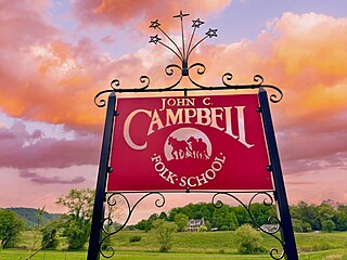
The John C. Campbell Folk School, also referred to as "The Folk School", is located in Brasstown, North Carolina. It is the oldest and largest folk school in the United States. It is a non-profit adult educational organization based on non-competitive learning. The Folk School offers classes year-round in over fifty subject areas including art, craft, music, dance, and nature studies. Established in 1925, the Folk School's motto is "I sing behind the plow".

<span class="mw-page-title-main">Fort Butler (Murphy, North Carolina)</span> 19th century fort in North America

Fort Butler was an important site during the Cherokee removal known as the Trail of Tears. Located on a hill overlooking present-day Murphy, North Carolina on the Hiwassee River, Fort Butler was the headquarters of the Eastern Division of the U.S. Army overseeing the Cherokee Nation. It was the military force charged with forcing Cherokee emigration.

<span class="mw-page-title-main">Warne, North Carolina</span> Unincorporated community in North Carolina, United States

Warne ( "worn") is an unincorporated community in Brasstown Township, Clay County, North Carolina, United States. In 2010, Clay County was the fourth least populated county in North Carolina, inhabited by approximately 10,587 people. The region has added considerably to its population, a 20.6% increase since 2000. Warne is closer to the capitals of five other states than to Raleigh, the capital of North Carolina.

<span class="mw-page-title-main">Southern Highroads Trail</span>

The Southern Highroads Trail is a 364-mile-long (586 km) loop of scenic and historic highways in the Southeastern United States. The driving trail traverses 14 counties, four states, and four national forests, providing sightseers and passersby an array of culinary, hotel, shopping, and recreational options along the way.

<span class="mw-page-title-main">Hiwassee Dam</span> Dam in North Carolina, United States

Hiwassee Dam is a hydroelectric dam on the Hiwassee River in Cherokee County, in the U.S. state of North Carolina. It is one of three dams on the river owned and operated by the Tennessee Valley Authority, which built the dam in the late 1930s to bring flood control and electricity to the region. The dam impounds the Hiwassee Lake of 6,000 acres (2,400 ha), and its tailwaters are part of Apalachia Lake. At 307 feet (94 m), Hiwassee Dam is the highest overspill dam east of the Mississippi River and is second only to Grand Coulee dam in the nation. At the time it was completed, it was the highest overspill dam in the world.

<span class="mw-page-title-main">Chatuge Dam</span> Dam in North Carolina, United States

Chatuge Dam is a flood control and hydroelectric dam on the Hiwassee River in Clay County, in the U.S. state of North Carolina. The dam is the uppermost of three dams on the river owned and operated by the Tennessee Valley Authority, which built the dam in the early 1940s for flood storage and to provide flow regulation at Hiwassee Dam further downstream. The dam impounds the 7,000-acre (2,800 ha) Chatuge Lake, which straddles the North Carolina-Georgia state line. While originally built solely for flood storage, a generator installed at Chatuge in the 1950s gives the dam a small hydroelectric output. At the time it was built, Chatuge Dam was the highest earthen dam in the world until the Aswan Dam was built in Egypt in 1964. The dam and associated infrastructure was listed on the National Register of Historic Places in 2017.

<span class="mw-page-title-main">Valley River</span> Stream in North Carolina, USA

The Valley River is a tributary of the Hiwassee River. It arises as a pair of springs in the Snowbird Mountains of Cherokee County, North Carolina and descends 2,960 feet (900 m) in elevation in approximately forty miles (64 km) to enter the Hiwassee embayment at present-day Murphy, North Carolina.

<span class="mw-page-title-main">Brasstown, North Carolina</span> Unincorporated community in North Carolina, United States

Brasstown is an unincorporated community located mostly within Clay County, North Carolina, United States, though roughly one third of Brasstown is within the adjacent Cherokee County. Brasstown Creek travels through the community and separates the two counties.

<span class="mw-page-title-main">Spikebuck Town Mound and Village Site</span> United States historic place

The Spikebuck Town Mound and Village Site is a prehistoric and historic archaeological site on Town Creek near its confluence with the Hiwassee River within the boundaries of present-day Hayesville, North Carolina. The site encompasses the former area of the Cherokee village of Quanassee and associated farmsteads. The village was centered on what is known as Spikebuck Mound, an earthwork platform mound, likely built about 1,000 CE by ancestral indigenous peoples during the South Appalachian Mississippian culture period.

<span class="mw-page-title-main">Clay County Courthouse (North Carolina)</span> United States historic place

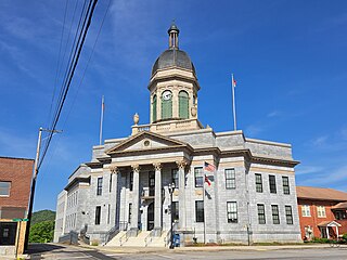
The Clay County Courthouse is located on Main Street in Hayesville, Clay County, North Carolina. The T-shaped two-story brick building was built in 1888, and is a prominent local example of vernacular Italianate architecture. Its most visible feature is a three-story square tower, which projects for half its width from the main facade, and through which entry to the building is gained.

<span class="mw-page-title-main">Peachtree, North Carolina</span> Community located in Cherokee County, North Carolina

Peachtree is a community located in Cherokee County, North Carolina. It is named after the numerous peach trees found in the area. The local schools are Peachtree Elementary School, Murphy and Andrews Middle School, and Murphy and Andrews High School.

<span class="mw-page-title-main">Mission Dam</span> Dam in North Carolina, United States

Mission Dam is a dam on the Hiwassee River in Clay County, in the U.S. state of North Carolina. The dam is located between Hiwassee Dam and Chatuge Dam. The city of Andrews, North Carolina built the dam in 1924 at a cost of $500,000 to supply energy. The dam is the oldest on the river. Nantahala Power and Light bought the facility in 1929 and upgraded it in 1943. Unlike other dams on the river, it is operated by Duke Energy instead of the Tennessee Valley Authority.

<span class="mw-page-title-main">Fort Hembree</span>

Tennessee militia established Fort Hembree 1 mile (1.6 km) southwest of the present town of Hayesville, North Carolina, in October 1837 to prepare for deporting local Cherokee Native Americans during the Trail of Tears. The fort was under the command of General Winfield Scott. Within two week Scott's forces captured around 1,000 Cherokee people who were held prisoner at the fort. A number of Cherokees were stricken with illness while at Fort Hembree and died at the site. The remainder were marched from there to Fort Butler near present-day Murphy and then to deportation camps in Tennessee.

<span class="mw-page-title-main">Nantahala Regional Library</span> Library system in western North Carolina

Nantahala Regional Library is the oldest regional library in North Carolina and one of the first regional libraries formed in the United States. Its headquarters is in Murphy, North Carolina. The library has branches in Cherokee, Clay, and Graham counties.

References

  1. "ArcGIS REST Services Directory". United States Census Bureau. Retrieved September 20, 2022.
  2. 1 2 U.S. Geological Survey Geographic Names Information System: Hayesville, North Carolina
  3. 1 2 "U.S. Census website". United States Census Bureau . Retrieved January 31, 2008.
  4. "Find a County". National Association of Counties. Retrieved June 7, 2011.
  5. Riggs, Brett H.; Duncan, Barbara R. (2003). Cherokee Heritage Trails Guidebook. Chapel Hill: University of North Carolina Press. p. 245. ISBN   0-8078-5457-3.
  6. "Quanassee Town and the Spikebuck Mound Historical Marker". www.hmdb.org. Retrieved April 13, 2024.
  7. "Fort Hembree". North Carolina Trail of Tears Association.
  8. 1 2 3 4 5 6 7 8 9 10 Moore, Carl S. (2008). Clay County, N.C.: Then and Now. Franklin, N.C.: Genealogy Publishing Service. ISBN   978-1881851240.
  9. 1 2 "Update E: Important Cherokee Valley Town Site, 5th Anniversary of Preservation". Archeological Conservancy. January 22, 2016. Retrieved January 10, 2021.
  10. Gannett, Henry (1905). The Origin of Certain Place Names in the United States. Govt. Print. Off. pp.  153.
  11. 1 2 3 4 5 6 7 Padgett, Guy (1976). A History of Clay County, North Carolina. Clay County Bicentennial Committee.
  12. Leek, Mark (2003). History of Clay County Schools From 1850 until Present. Doctoral project in the Issues of Rural Education class at Western Carolina University.
  13. Lewis, J.D. "Cherokee County, NC Post Offices - 1839 to 1971". Carolana.com.
  14. Laney, Gideon Thomas. "Train from Hayesville arriving at the Tusquittee station pulled by Climax locomotive #10". Southern Appalachian Digital Collections. Western Carolina University and University of North Carolina Asheville. Retrieved February 27, 2024.
  15. "Parts of Business District of Hayesville Destroyed by Fire". The Cherokee Scout. Murphy, NC. January 26, 1922. p. A1.
  16. "Cherokee Culture". Clay County Communities Revitalization Association. 2019–2021. Retrieved January 10, 2021.
  17. 1 2 "History of the Nantahala Regional Library". Nantahala Regional Library. Murphy, NC. Retrieved March 4, 2024.
  18. 1 2 "Clay ready to start library construction; fund raising meeting set for Friday". The Cherokee Scout and Clay County Progress. June 23, 1966. p. 9.
  19. "Moss Library Dedicated Sunday". The Cherokee Scout and Clay County Progress. June 29, 1967. p. 4.
  20. Moore, Carl S. (2008). Clay County, N.C.: Then and Now. Franklin, N.C.: Genealogy Publishing Service. ISBN   978-1881851240.
  21. "National Register Database and Research - National Register of Historic Places (U.S. National Park Service)". www.nps.gov. Retrieved March 15, 2024.
  22. Sposto, Caroline (June 20, 2021). "Learn More About the Peacock Performing Arts Center in Hayesville". Broadway World. Wisdom Digital Media. Retrieved February 10, 2024.
  23. Smith, Melissa C. (August 1, 2011). "The Little Theatre That Could". WNC Magazine. North Carolina: Gulfstream Communications.
  24. Long, Becky (November 30, 2023). "Highway 69 completion set for July '24". Clay County Progress. Hayesville, NC: Community Newspapers, Inc. Retrieved February 20, 2024.
  25. "About Us". Clay County Recreation Center & Parks. Retrieved April 19, 2024.
  26. "North Carolina Newspapers". Newspapers.DigitalNC.org. Digital NC.
  27. "Clay County Schools". Clay County School District. Retrieved February 10, 2024.
  28. "Tri-County Community College - -". Tri-County Community College. Retrieved February 23, 2016.
  29. "A private, four-year, liberal arts college located in the mountains of North Georgia". Young Harris College. Retrieved February 23, 2016.
  30. "Western Carolina University - Home | Choose Great". Home | Choose Great. Retrieved November 1, 2018.
  31. Eiben, Vicky (2015). "A brief history of folk schools". Folk Education Association of America. Folk School Alliance. The John C. Campbell Folk School founded in 1925 in Brasstown, North Carolina is the largest folk school in the U.S. today.
  32. "region: Brasstown, Hayesville". Great Smoky Mountains North Carolina. Nation's oldest folk school founded in 1925.
  33. "John C. Campbell Folk School". www.folkschool.org. Retrieved February 23, 2016.
  34. "Census of Population and Housing". Census.gov. Retrieved June 4, 2015.
  35. "Explore Census Data". data.census.gov. Retrieved December 19, 2021.
  36. "U.S. Census Bureau data provided by GreatData.com" . Retrieved February 6, 2013.
  37. Keely, Harrison (March 17, 2010). "The Life and Death of Mark Linkous: The Elusive Artist". WNC Sentinel. Archived from the original on April 18, 2011. Retrieved April 13, 2011.

Further reading