Dobson, North Carolina

Last updated

Dobson, North Carolina
Dobson, North Carolina.jpg
West Atkins Street
Dobson, NC Town Seal.jpg
NCMap-doton-Dobson.PNG
Location of Dobson, North Carolina
Coordinates: 36°23′34″N80°43′28″W / 36.39278°N 80.72444°W / 36.39278; -80.72444
Country United States
State North Carolina
County Surry
Government
  TypeLocal/Municipal
  MayorRicky Draughn
  Town ManagerLaura Neely
Area
[1]
  Total2.04 sq mi (5.29 km2)
  Land2.03 sq mi (5.26 km2)
  Water0.01 sq mi (0.03 km2)
Elevation
[2]
1,230 ft (370 m)
Population
 (2020)
  Total1,462
  Density719.84/sq mi (277.97/km2)
Time zone UTC-5 (Eastern (EST))
  Summer (DST) UTC-4 (EDT)
ZIP code
27017
Area code 336
FIPS code 37-17340 [3]
GNIS feature ID2406382 [2]
Website www.dobson-nc.com

Dobson is a town in Dobson Township, Surry County, North Carolina, United States. As of the 2020 census, [4] the town population was 1,396. It is the county seat of Surry County. [5] Dobson is the home of the Shelton Vineyards, the largest winery in North Carolina. It is also home to a significant Latino population due to the large number of farms in the area. The main crops in the area are corn, tobacco and soy beans.

Contents

History

Dobson was established as the county seat in 1853, replacing Rockford after all land in Surry County south of the Yadkin River was used to form Yadkin County.

The Edwards-Franklin House and Surry County Courthouse are listed on the National Register of Historic Places. [6]

Geography

According to the United States Census Bureau, the town has a total area of 1.8 square miles (4.7 km2), all land.

Demographics

Historical population
CensusPop.Note
1900 327
1910 36010.1%
1920 3682.2%
1930 44621.2%
1940 52016.6%
1950 60917.1%
1960 68412.3%
1970 93336.4%
1980 1,22231.0%
1990 1,195−2.2%
2000 1,45721.9%
2010 1,5868.9%
2020 1,396−12.0%
2021 (est.)1,390 [4] −0.4%
U.S. Decennial Census [7] [8]

2020 census

Dobson racial composition [9]
RaceNumberPercentage
White (non-Hispanic)1,06272.64%
Black or African American (non-Hispanic)644.38%
Native American 90.62%
Asian 302.05%
Other/Mixed 402.74%
Hispanic or Latino 25717.58%

As of the 2020 United States census, there were 1,462 people, 657 households, and 327 families residing in the town.

2000 census

As of the census [3] of 2000, there were 1,457 people, 555 households, and 339 families living in the town. The population density was 813.8 inhabitants per square mile (314.2/km2). There were 594 housing units at an average density of 331.8 per square mile (128.1/km2). The racial makeup of the town was 75.84% White, 3.91% African American, 0.41% Native American, 19.42% from other races, and 0.41% from two or more races. Hispanic or Latino of any race were 25.81% of the population.

There were 555 households, out of which 29.2% had children under the age of 18 living with them, 45.6% were married couples living together, 9.4% had a female householder with no husband present, and 38.9% were non-families. 33.7% of all households were made up of individuals, and 18.4% had someone living alone who was 65 years of age or older. The average household size was 2.37 and the average family size was 3.03.

In the town, the population was spread out, with 23.0% under the age of 18, 11.9% from 18 to 24, 29.0% from 25 to 44, 18.9% from 45 to 64, and 17.2% who were 65 years of age or older. The median age was 35 years. For every 100 females, there were 108.1 males. For every 100 females age 18 and over, there were 100.0 males.

The median income for a household in the town was $26,765, and the median income for a family was $34,792. Males had a median income of $22,050 versus $21,000 for females. The per capita income for the town was $19,346. About 17.8% of families and 23.3% of the population were below the poverty line, including 28.6% of those under age 18 and 22.9% of those age 65 or over.

Notable people

See also

Related Research Articles

<span class="mw-page-title-main">Mason County, Washington</span> County in Washington, United States

Mason County is a county located in the U.S. state of Washington. As of the 2020 census, the population was 65,726. The county seat and only incorporated city is Shelton. The county was formed out of Thurston County on March 13, 1854. Originally named Sawamish County, it took its present name in 1864 in honor of Charles H. Mason, the first Secretary of Washington Territory.

<span class="mw-page-title-main">Yadkin County, North Carolina</span> County in North Carolina, United States

Yadkin County is located in the U.S. state of North Carolina. As of the 2020 census, the population was 37,214. Its county seat is Yadkinville. Yadkin County is included in the Winston-Salem, NC Metropolitan Statistical Area, which is also included in the Greensboro–Winston-Salem–High Point, NC Combined Statistical Area.

<span class="mw-page-title-main">Surry County, North Carolina</span> County in North Carolina, United States

Surry County is a county located in the U.S. state of North Carolina. As of the 2020 census, the population was 71,359. Its county seat is Dobson, and its largest community is Mount Airy.

<span class="mw-page-title-main">Forsyth County, North Carolina</span> County in North Carolina, United States

Forsyth County is located in the northwest Piedmont of the U.S. state of North Carolina. As of the 2020 census, the population was 382,590, making it the fourth-most populous county in North Carolina. Its county seat is Winston-Salem. Forsyth County is part of the Winston-Salem, NC, Metropolitan Statistical Area, which is also included in the Greensboro–Winston-Salem–High Point, NC, Combined Statistical Area. Portions of Forsyth County are in the Yadkin Valley wine region.

<span class="mw-page-title-main">Rogersville, Alabama</span> Town in Alabama, United States

Rogersville is a town in Lauderdale County, Alabama, United States. As of the 2018 census, the population of the town is 1,231, up from 1,199 in 2000.

<span class="mw-page-title-main">Cushman, Arkansas</span> City in Arkansas, United States

Cushman is a city in Independence County, Arkansas, United States. The population was 433 at the 2020 census.

<span class="mw-page-title-main">Caldwell, Arkansas</span> Town in Arkansas, United States

Caldwell is a town in St. Francis County, Arkansas, United States. The population was 555 at the 2010 census, an increase from 465 in 2000.

<span class="mw-page-title-main">Sumner, Iowa</span> City in Iowa, United States

Sumner is a city in Bremer County, Iowa, United States. The city is located along the county's eastern border, between Bremer and Fayette counties. The population was 2,021 at the time of the 2020 census. The Bremer County portion of Sumner is part of the Waterloo–Cedar Falls Metropolitan Statistical Area.

Surry is a town in Hancock County, Maine, United States. The population was 1,632 at the 2020 census.

<span class="mw-page-title-main">Surry, New Hampshire</span> Town in New Hampshire, United States

Surry is a town in Cheshire County, New Hampshire, United States. The population was 820 at the 2020 census, up from 732 at the 2010 census.

Bermuda Run is a town in Davie County, North Carolina, United States. As of the 2020 census, the population of the town was 3,120. It was incorporated in 1999 as a fully gated residential community near country clubs and golf courses like the Bermuda Run Country Club, Oak Valley Golf Club, and Tanglewood Park. In 2000, the town annexed into neighboring Hillsdale, picking up a commercial district. The town rests on the western bank of the Yadkin River along U.S. Route 158 and North Carolina Highway 801. Interstate 40 provides express access to Winston-Salem, the town's nearest urban center. In 2012, Kinderton Village was voluntarily annexed by the town of Bermuda Run. Bermuda Run is considered by the locals to be a mid-high class community and the second-most influential, behind nearby Oak Valley.

<span class="mw-page-title-main">Rural Hall, North Carolina</span> Town in North Carolina, United States

Rural Hall is a town in Forsyth County, North Carolina, United States. It is a part of the Piedmont Triad. The population was 3,360 at the 2020 census. The town has one public park: Covington Memorial Park.

<span class="mw-page-title-main">Pilot Mountain, North Carolina</span> Town in North Carolina, United States

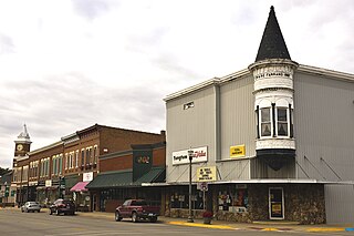
Pilot Mountain is a town in Surry County, North Carolina, United States. The population was 1,443 at the 2020 census. It is named for the nearby landmark of Pilot Mountain, a distinctive geological formation.

<span class="mw-page-title-main">Ronda, North Carolina</span> Town in North Carolina, United States

Ronda is a town in Wilkes County, North Carolina, United States. The population was 417 at the 2010 census, and 413 at the 2020 census. Ronda was named after a nearby estate called "Roundabout", which was the residence of Benjamin Cleveland, a locally prominent planter and a colonel in the North Carolina militia during the Revolutionary War. The town is home to East Wilkes High School, one of Wilkes County's five public high schools.

<span class="mw-page-title-main">Boonville, North Carolina</span> Town in North Carolina, United States

Boonville is a town in Yadkin County, North Carolina, United States. The population was 1,222 at the 2010 census.

<span class="mw-page-title-main">Jonesville, North Carolina</span> Town in North Carolina, United States

Jonesville, originally called Allen's Settlement, is the oldest town in Yadkin County, North Carolina, United States. The population was 2,285 at the 2010 census. The town grew by nearly 800 residents in 2001 when it merged with neighboring Arlington. Recognized as the Heart of the Yadkin Valley, Jonesville is a gateway to the Blue Ridge Mountains, the Yadkin Valley Heritage/Cultural Corridor and to local wineries in the Swan Creek AVA and the larger Yadkin Valley AVA, as well as offering access to the Yadkin river.

<span class="mw-page-title-main">Yadkinville, North Carolina</span> Town in North Carolina, United States

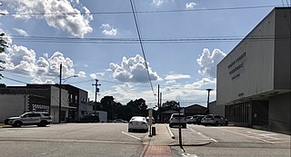
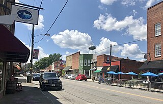
Yadkinville is a town in Yadkin County, North Carolina, United States. The population was 2,995 at the 2020 census. Located in the Piedmont Triad, it is the county seat and most populous city of Yadkin County.

<span class="mw-page-title-main">Ryan Township, Pennsylvania</span> Township in Pennsylvania, United States

Ryan Township is a township in Schuylkill County, Pennsylvania, United States. The population was 2,526 at the 2020 census.

<span class="mw-page-title-main">Surry, Virginia</span> Town in Virginia, United States

Surry is an incorporated town in Surry County, Virginia, United States. The population was 244 at the 2010 census. It is the county seat of Surry County. Its name is derived from the historic county of Surrey in England.

Siloam is an unincorporated community in southeastern Surry County, North Carolina, United States. The Yadkin River makes up the community's southern border, and the Ararat River flows between it and the community of Shoals to the east. It is a Piedmont Triad community.

References

  1. "ArcGIS REST Services Directory". United States Census Bureau. Retrieved September 20, 2022.
  2. 1 2 U.S. Geological Survey Geographic Names Information System: Dobson, North Carolina
  3. 1 2 "U.S. Census website". United States Census Bureau . Retrieved January 31, 2008.
  4. 1 2 "City and Town Population Totals: 2020-2021". Census.gov. US Census Bureau. Retrieved July 9, 2022.
  5. "Find a County". National Association of Counties. Archived from the original on May 31, 2011. Retrieved June 7, 2011.
  6. "National Register Information System". National Register of Historic Places . National Park Service. July 9, 2010.
  7. "Census of Population and Housing". Census.gov. Retrieved June 4, 2015.
  8. "Census of Population and Housing". Census.gov. Retrieved June 4, 2016.
  9. "Explore Census Data". data.census.gov. Retrieved December 21, 2021.
  10. "Archived copy" (PDF). Archived from the original (PDF) on April 23, 2007. Retrieved May 2, 2007.{{cite web}}: CS1 maint: archived copy as title (link)