Washington, North Carolina

Last updated

Washington, North Carolina
Washington, North Carolina 1.jpg
Washington from the corner of Stewart Street and West Main Street
Washington, NC City Flag.jpg
Washington, NC Town Seal.jpg
Nickname(s): 
Little Washington, Original Washington
USA North Carolina location map.svg
Red pog.svg
Washington
Location within the state of North Carolina
Coordinates: 35°33′13″N77°03′16″W / 35.55361°N 77.05444°W / 35.55361; -77.05444
CountryUnited States
State North Carolina
County Beaufort
Government
  TypeCouncil-Manager form of government
  MayorDonald Sadler
Area
[1]
  Total9.02 sq mi (23.37 km2)
  Land8.19 sq mi (21.21 km2)
  Water0.83 sq mi (2.16 km2)
Elevation
[2]
7 ft (2 m)
Population
 (2020)
  Total9,875
  Density1,205.74/sq mi (465.55/km2)
Time zone UTC−5 (Eastern (EST))
  Summer (DST) UTC−4 (EDT)
ZIP Code
27889
Area code 252
FIPS code 37-71220 [3]
GNIS feature ID2405682 [2]
Websitewww.washingtonnc.gov

Washington is a city in Beaufort County, North Carolina, United States, located on the northern bank of the Pamlico River. The population was 9,875 at the 2020 census. [4] It is the county seat of Beaufort County. [5] It is commonly known as "Original Washington" or "Little Washington" to distinguish it from Washington, D.C. [6] [7] The closest major city is Greenville, approximately 20 miles (32 km) to the west.

Contents

Established in 1776 on land donated by Col. James Bonner, Washington is the first city named after George Washington, the first president of the United States. [8]

History

Washington Municipal Building Washington, North Carolina municipal building.jpg
Washington Municipal Building

The settlement at the current location of the city was founded in the 1770s by James Bonner on his land and was known as Forks of the Tar. In 1776, it was renamed Washington. During the American Revolutionary War, Washington served as a supply port when major neighboring ports were under British siege. [9]

Geography

Climate

Climate data for Washington, North Carolina (1981–2010 normals), [lower-alpha 1]
MonthJanFebMarAprMayJunJulAugSepOctNovDecYear
Mean daily maximum °F (°C)53.8
(12.1)
56.9
(13.8)
63.8
(17.7)
72.8
(22.7)
80.5
(26.9)
87.3
(30.7)
89.7
(32.1)
88.3
(31.3)
83.2
(28.4)
74.1
(23.4)
65.6
(18.7)
56.8
(13.8)
72.7
(22.6)
Mean daily minimum °F (°C)34.2
(1.2)
36.4
(2.4)
41.9
(5.5)
50.3
(10.2)
59.3
(15.2)
68.5
(20.3)
72.5
(22.5)
70.9
(21.6)
65.4
(18.6)
53.5
(11.9)
44.5
(6.9)
35.7
(2.1)
52.8
(11.6)
Average precipitation inches (mm)3.85
(98)
3.32
(84)
4.22
(107)
3.14
(80)
4.11
(104)
4.44
(113)
5.45
(138)
5.22
(133)
5.81
(148)
3.28
(83)
3.2
(81)
3.26
(83)
49.3
(1,250)
Average snowfall inches (cm)0.5
(1.3)
0.4
(1.0)
0.2
(0.51)
0.1
(0.25)
0
(0)
0
(0)
0
(0)
0
(0)
0
(0)
0
(0)
0
(0)
0.8
(2.0)
2
(5.1)
Source: NOAA (Monthly Climate Normals) [10]

Demographics

Historical population
CensusPop.Note
1850 2,015
1860 1,599−20.6%
1870 2,09431.0%
1880 2,46217.6%
1890 3,54544.0%
1900 4,84236.6%
1910 6,21128.3%
1920 6,3141.7%
1930 7,03511.4%
1940 8,56921.8%
1950 9,69813.2%
1960 9,9392.5%
1970 8,961−9.8%
1980 8,418−6.1%
1990 9,0757.8%
2000 9,5835.6%
2010 9,7441.7%
2020 9,8751.3%
U.S. Decennial Census [11]

2020 census

Washington Racial Composition [12]
RaceNum.Perc.
White 4,48345.4%
Black or African American 4,25243.06%
Native American 200.2%
Asian 730.74%
Pacific Islander 10.01%
Other/Mixed 3323.36%
Hispanic or Latino 7147.23%

As of the 2020 United States Census, there were 9,875 people, 4,038 households, and 2,251 families residing in the city.

2010 census

As of the census [3] of 2010, there were 9,744 people and 4,246 households in the city. The population density was 1,190.0 inhabitants per square mile (459.5/km2). There were 4,754 housing units at an average density of 580.5 per square mile (224.1/km2). The racial composition of the city was: 49.0% White, 45.50% Black or African American, 5.5% Hispanic or Latino American, 0.5% Asian American, 0.2% Native American, 0.1% Native Hawaiian or Other Pacific Islander, and 1.50% two or more races.

There were 4,754 households, out of which 22.5% had children under the age of 18 living with them, 37.3% were married couples living together, 21.1% had a female householder with no husband present, and 37.8% were non-families. 33.5% of all households were made up of individuals, and 15.3% had someone living alone who was 65 years of age or older. The average household size was 2.21 and the average family size was 2.93.

In the city, the age distribution of the population shows 24.7% under the age of 18, 8.6% from 18 to 24, 24.5% from 25 to 44, 22.6% from 45 to 64, and 19.6% who were 65 years of age or older. The median age was 40 years. For every 100 females, there were 77.4 males. For every 100 females age 18 and over, there were 70.8 males.

The median income for a household in the city was $22,057, and the median income for a family was $30,280. Males had a median income of $26,053 versus $21,641 for females. The per capita income for the city was $14,319. About 23.3% of families and 28.7% of the population were below the poverty line, including 42.8% of those under age 18 and 19.3% of those age 65 or over.

Arts and culture

Map of Washington during the American Civil War OP 64 Map of Tar River, NC (9091346619).jpg
Map of Washington during the American Civil War
North Carolina Estuarium Washingtonestuarium.png
North Carolina Estuarium

Washington has a range of historical buildings and landmarks, with some dating back to colonial and Victorian eras. [13] Historic sites include the Bank of Washington, West End Branch, Beaufort County Courthouse, Bowers-Tripp House, North Market Street Historic District, Rosedale, Washington Historic District, and Zion Episcopal Church are listed on the National Register of Historic Places. [14]

A Farmer's and Artisan's Market is held regularly on the town's green areas on the waterfront.

The North Carolina Estuarium along the Pamlico River holds more than 200 scientific and historic exhibits relating to the ecology of North Carolina's estuaries, the Tar-Pamlico River and Pamlico Sound. The Estuarium also includes a 3/4 mile boardwalk along the Pamlico River.

The Turnage Theatre, a restored building with a historic vaudeville theater and movie theater, reopened in the downtown area in 2014 and hosts plays and other live entertainment. [15] Between 1993 and 2017 a downtown music and art festival called "Music in the Streets" was held every third Friday during summer to attract people to downtown shops and restaurants. [16]

A cannonball from the Union attack on Washington during the American Civil War is displayed in an attorney's office on Water Street, and many nearby towns also contain Civil War artifacts and museums. Civil War re-enactors meet in the outskirts of Washington every year.

BHM Regional Library operates the Washington Public Library. [17]

Education

Public education is administered by Beaufort County Schools. Schools located in Washington include:

Media

Print

The Washington Daily News was awarded the Pulitzer Prize for Meritorious Public Service in 1990 for a series of stories concerning local water contamination, making it the smallest daily newspaper in history to win the award.[ citation needed ]

In 2009, the newspaper The Beaufort Observer went from a bi-monthly print publication to an online publication.

Television

Beaufort County Courthouse Beaufort County Courthouse.JPG
Beaufort County Courthouse

WITN is licensed to Washington.[ citation needed ]

Radio

The following radio stations are licensed to Washington:

Notable people

Notes

  1. Mean monthly maxima and minima (i.e. the expected highest and lowest temperature readings at any point during the year or given month) calculated based on data at said location from 1981 to 2010.

Related Research Articles

<span class="mw-page-title-main">Beaufort County, South Carolina</span> County in South Carolina, United States

Beaufort County is a county in the U.S. state of South Carolina. As of the 2020 census, its population was 187,117. Its county seat is Beaufort and its largest community is Hilton Head Island.

<span class="mw-page-title-main">Washington County, North Carolina</span> County in North Carolina, United States

Washington County is a county located in the U.S. state of North Carolina. As of the 2020 census, the population was 11,003. Its county seat is Plymouth. The county was formed in 1799 from the western third of Tyrrell County. It was named for George Washington.

<span class="mw-page-title-main">Pitt County, North Carolina</span> County in North Carolina, United States

Pitt County is a county located in the Inner Banks region of the U.S. state of North Carolina. As of the 2020 census, the population was 170,243, making it the 14th-most populous county in North Carolina. Its county seat is Greenville.

<span class="mw-page-title-main">Pamlico County, North Carolina</span> County in North Carolina, United States

PamlicoCounty is a county located in the U.S. state of North Carolina. As of the 2020 census, the population was 12,276. Its county seat is Bayboro.

<span class="mw-page-title-main">Edgecombe County, North Carolina</span> County in North Carolina, United States

Edgecombe County is a county located in the U.S. state of North Carolina. As of the 2020 census, the population was 48,900. Its county seat is Tarboro.

<span class="mw-page-title-main">Dare County, North Carolina</span> County in North Carolina, United States

Dare County is the easternmost county in the U.S. state of North Carolina. As of the 2020 census, the population was 36,915. Its county seat is Manteo.

<span class="mw-page-title-main">Carteret County, North Carolina</span> County in North Carolina, United States

Carteret County is a county located in the U.S. state of North Carolina. As of the 2020 census, the population was 67,686. Its county seat is Beaufort. The county was created in 1722 as Carteret Precinct and gained county status in 1739. It was named for Sir George Carteret, one of the 17th century English Lords Proprietor, or for his descendant and heir John Carteret, 2nd Earl Granville.

<span class="mw-page-title-main">Beaufort County, North Carolina</span> County in North Carolina, United States

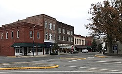
Beaufort County is a county located in the U.S. state of North Carolina. As of the 2020 census, the population was 44,652. Its county seat is Washington. The county was founded in 1705 as Pamptecough Precinct. Originally included in Bath County, it was renamed Beaufort Precinct in 1712 and became Beaufort County in 1739.

<span class="mw-page-title-main">Isle, Minnesota</span> City in Minnesota, United States

Isle is a city in Mille Lacs County, Minnesota, United States. The population was 803 at the 2020 census, up from 751 in 2010.

<span class="mw-page-title-main">Graham, North Carolina</span> City in North Carolina, United States

Graham is a city in Alamance County, North Carolina, United States. It is part of the Burlington, North Carolina Metropolitan Statistical Area. As of the 2020 census the population was 17,153. It is the county seat of Alamance County.

<span class="mw-page-title-main">Aurora, North Carolina</span> Town in North Carolina, United States

Aurora is a town in Beaufort County, North Carolina, United States. The population was 520 at the 2010 Census.

<span class="mw-page-title-main">Bath, North Carolina</span> Town in North Carolina, United States

Bath is a town in Beaufort County, North Carolina, United States. Located on the Pamlico River, it developed a trade in naval stores, furs, and tobacco. The population was 249 as of 2010. North Carolina’s first town and port of entry, it was chartered on March 8, 1705.

<span class="mw-page-title-main">Belhaven, North Carolina</span> Town in North Carolina, United States

Belhaven is a waterfront town in Beaufort County, North Carolina, United States. The population was 1,688 at the 2010 census. Belhaven is located in North Carolina's Inner Banks region.

River Road is a census-designated place (CDP) in Beaufort County, North Carolina, United States. The population was 4,048 at the 2020 Census.

<span class="mw-page-title-main">Beaufort, North Carolina</span> Town in North Carolina, United States

Beaufort is a town in and the county seat of Carteret County, North Carolina, United States. Established in 1713 and incorporated in 1723, Beaufort is the fourth oldest town in North Carolina . On February 1, 2012, Beaufort was ranked as "America's Coolest Small Town" by readers of Budget Travel Magazine.

<span class="mw-page-title-main">Morehead City, North Carolina</span> Town in North Carolina, United States

Morehead City is a port town in Carteret County, North Carolina, United States. The population was 8,661 at the 2010 census. Morehead City celebrated the 150th anniversary of its founding on May 5, 2007. It forms part of the Crystal Coast.

<span class="mw-page-title-main">Arapahoe, North Carolina</span> Town in North Carolina, United States

Arapahoe is a town in Pamlico County, North Carolina, United States. As of the 2010 census, the town population was 556. Arapahoe shares many of its roles and duties with Minnesott Beach, North Carolina. It is part of the New Bern, North Carolina Micropolitan Statistical Area.

<span class="mw-page-title-main">Creswell, North Carolina</span> Town in North Carolina, United States

Creswell is a town in Washington County, North Carolina, United States. The population was 207 at the 2020 census.

<span class="mw-page-title-main">Plymouth, North Carolina</span> Town in North Carolina, United States

Plymouth is the most populous town in Washington County, North Carolina, United States. The population was 3,320 at the 2020 census. It is the county seat of Washington County. Plymouth is located on the Roanoke River about seven miles (11 km) upriver from its mouth into the Albemarle Sound in North Carolina's Inner Banks region.

<span class="mw-page-title-main">Lancaster, South Carolina</span> City in South Carolina, United States

The city of Lancaster is the county seat of Lancaster County, South Carolina, United States, located in the Charlotte Metropolitan Area. As of the United States Census of 2010, the city population was 8,526. The city was named after the famous House of Lancaster.

References

  1. "ArcGIS REST Services Directory". United States Census Bureau. Retrieved September 20, 2022.
  2. 1 2 U.S. Geological Survey Geographic Names Information System: Washington, North Carolina
  3. 1 2 "U.S. Census website". United States Census Bureau . Retrieved January 31, 2008.
  4. "Washington city, North Carolina - Census Bureau Profile". United States Census Bureau. Retrieved January 26, 2024.
  5. "Find a County". National Association of Counties. Retrieved June 7, 2011.
  6. "Washington | Beaufort County North Carolina". co.beaufort.nc.us. Retrieved May 14, 2021.
  7. Sutton Anders, Robin (July 22, 2020). "5 Ways to Spend a Weekend in Little Washington". Our State Magazine.
  8. "Frequently Asked Questions". City of Washington Official Website. Retrieved January 30, 2014.
  9. "History". City of Washington, North Carolina. Retrieved March 12, 2014.
  10. "NOAA 1981-2010 Climate Normals". NOAA Regional Climate Centers . Retrieved January 19, 2018.
  11. "Census of Population and Housing". Census.gov. Retrieved June 4, 2015.
  12. "Explore Census Data". data.census.gov. Retrieved December 7, 2021.
  13. Rumley, Vail Stewart (April 19, 2018). "Historic walking tour a great way to experience Washington". Washington Daily News. Retrieved August 5, 2018.
  14. "National Register Information System". National Register of Historic Places . National Park Service. July 9, 2010.
  15. "Arts of the Pamlico celebrates mortgage pay off on Turnage Theatre". WITN. June 7, 2018. Retrieved August 5, 2018.
  16. Rumley, Vail Stewart (February 21, 2017). "WHDA suspends Music in the Streets". Washington Daily News. Retrieved August 5, 2018.
  17. "Washington". BHM Regional Library. October 12, 2016. Retrieved April 13, 2021.
  18. "Early College High School". Beaufort County Schools. Retrieved June 18, 2022.
  19. "Eastern Elementary School". Beaufort County Schools. Retrieved June 18, 2022.
  20. "J.C. Tayloe Elementary School". Beaufort County Schools. Retrieved June 18, 2022.
  21. "John Small Elementary School". Beaufort County Schools. Retrieved June 18, 2022.
  22. "P.S. Jones Middle School". Beaufort County Schools. Retrieved June 18, 2022.
  23. "Washington High School". Beaufort County Schools. Retrieved June 18, 2022.