Snow Hill, North Carolina

Last updated

Snow Hill, North Carolina
Snow Hill, North Carolina.jpg
Snow Hill, NC Town Seal.jpg
Motto: 
"A Nice Place to Live"
NCMap-doton-SnowHill.PNG
Location of Snow Hill, North Carolina
Coordinates: 35°27′02″N77°40′36″W / 35.45056°N 77.67667°W / 35.45056; -77.67667
Country United States
State North Carolina
County Greene
Founded1811 [1]
Incorporated1828 [1]
Named for A nearby plantation [1]
Government
   Mayor Dennis Liles
Area
[2]
  Total1.54 sq mi (3.99 km2)
  Land1.54 sq mi (3.99 km2)
  Water0.00 sq mi (0.00 km2)
Elevation
[3]
72 ft (22 m)
Population
 (2020)
  Total1,481
  Density962.31/sq mi (371.64/km2)
Time zone UTC-5 (Eastern (EST))
  Summer (DST) UTC-4 (EDT)
ZIP code
28580
Area code 252
FIPS code 37-62760 [4]
GNIS feature ID2407362 [3]
Website www.snowhillnc.com

Snow Hill is a town in Greene County, North Carolina, United States. The population was 1,595 at the 2010 census. [5] It is the county seat of Greene County [6] and is part of the Greenville Metropolitan Area. Snow Hill hosts numerous tennis tournaments during the year. Snow Hill is home to the Green Ridge Racquet Club. Many junior players and adults travel to Snow Hill in order to play in the USTA (United States Tennis Association) Sanctioned tournaments.

Contents

History

In its early history, Snow Hill was near the location of the final major battle of the Tuscarora War at Fort Neoheroka in 1713. There are several theories for the derivation of the town's name. One theory is that the town derived its name from the Contentnea Creek on whose banks Native Americans camped and called them "snowy white," which was translated into "snowy hills." It snows rarely, however, so the snowy white is more likely a reference to the white sands along the creek. Another theory was described by McLoud in the Goldsboro newspaper as being "loblolly pine is in water," and the most recent translation from the Tuscarora language offered was "as fish go by."

Originally a community in central Greene County, the town of Snow Hill was chartered in 1828. The town almost became the capital of North Carolina[ citation needed ] and was originally a major trading depot on Contentnea Creek. At the time, Contentnea Creek was a main Wilson-to-New Bern trading artery. Contentnea Creek connects with the Neuse River at Kinston. [7]

It is believed Snow Hill is the smallest town in the United States to ever field a professional baseball team. From 1937-40, the Snow Hill Billies played in the Class D Coastal Plain League and won the league pennant in 1937. Future New York Yankees Aaron Robinson and Al Gettel began their careers with the Billies, as did Walter Rabb, who would serve as head baseball coach at the University of North Carolina at Chapel Hill for nearly thirty years. [8]

In April 2011, a tornado struck the town and caused massive damage.

The Greene County Courthouse, Neoheroka Fort Site, Snow Hill Colored High School, Snow Hill Historic District, and St. Barnabas Episcopal Church are listed on the National Register of Historic Places. [9]

Geography

Snow Hill is located south of the center of Greene County on a low bluff on the south side of Contentnea Creek. U.S. Route 13 passes through the north side of town, leading northeast 23 miles (37 km) to Greenville and southwest 21 miles (34 km) to Goldsboro. U.S. Route 258 passes through the center of town, leading north 11 miles (18 km) to Farmville and south 16 miles (26 km) to Kinston.

According to the United States Census Bureau, Snow Hill has a total area of 1.5 square miles (4.0 km2), all land. [5]

Demographics

Historical population
CensusPop.Note
1870 320
1880 3323.8%
1890 283−14.8%
1900 40543.1%
1910 45011.1%
1920 70055.6%
1930 82618.0%
1940 92812.3%
1950 9461.9%
1960 1,04310.3%
1970 1,35930.3%
1980 1,3741.1%
1990 1,3780.3%
2000 1,5149.9%
2010 1,5955.4%
2020 1,481−7.1%
U.S. Decennial Census [10]

2020 census

Snow Hill racial composition [11]
RaceNumberPercentage
White (non-Hispanic)58439.43%
Black or African American (non-Hispanic)67945.85%
Native American 40.27%
Asian 161.08%
Other/Mixed 453.04%
Hispanic or Latino 15310.33%

As of the 2020 United States census, there were 1,481 people, 760 households, and 480 families residing in the town.

2010 census

As of the 2010 United States Census, there were 1,595 people living in the town. The racial makeup of the town was 52.6% Black, 36.3% White, 0.2% Native American, 1.1% Asian, 0.1% from some other race and 1.1% from two or more races. 8.7% were Hispanic or Latino of any race.

2000 census

As of the census [4] of 2000, there were 1,514 people, 627 households, and 381 families living in the town. The population density was 1,286.8 inhabitants per square mile (496.8/km2). There were 683 housing units at an average density of 580.5 per square mile (224.1/km2). The racial makeup of the town was 48.81% African American, 47.03% White, 0.40% Native American, 0.07% Asian, 2.97% from other races, and 0.73% from two or more races. Hispanic or Latino of any race were 3.30% of the population.

There were 627 households, out of which 23.9% had children under the age of 18 living with them, 38.0% were married couples living together, 18.7% had a female householder with no husband present, and 39.2% were non-families. 36.5% of all households were made up of individuals, and 17.4% had someone living alone, who was 65 years of age or older. The average household size was 2.20 and the average family size was 2.85.

In the town, the population was spread out, with 18.9% under the age of 18, 8.7% from 18 to 24, 23.3% from 25 to 44, 24.4% from 45 to 64, and 24.6% who were 65 years of age or older. The median age was 44 years. For every 100 females, there were 81.1 males. For every 100 females age 18 and over, there were 74.9 males.

The median income for a household in the town was $25,795, and the median income for a family was $29,213. Males had a median income of $25,625 versus $20,556 for females. The per capita income for the town was $15,904. About 15.3% of families and 20.5% of the population were below the poverty line, including 24.1% of those under age 18 and 26.5% of those age 65 or over.

Education

Schools in Snow Hill are administered by the Greene County Public School system. The six schools include Greene Central High School, Greene Early College High School, Greene County Middle School, Greene County Intermediate School, Snow Hill Primary School and West Greene Elementary School. [12] Higher education is provided through nearby East Carolina University or community colleges located in Goldsboro, Greenville and Kinston.

Transportation

The closest airport to Snow Hill is Pitt-Greenville Airport ( IATA : PGV, ICAO : KPGV, FAA LID : PGV) with service to Charlotte Douglas International Airport, although most residents use Raleigh-Durham International Airport for domestic and international travel.

Highways that run through the city include US 13, US 258, NC 903, NC 58 and NC 91. The closest Interstate Highway is I-795, located 21 miles (34 km) to the west in Fremont.

Notable people

Related Research Articles

<span class="mw-page-title-main">Wilson County, North Carolina</span> County in North Carolina, United States

Wilson County is a county located in the U.S. state of North Carolina. As of the 2020 census, the population was 78,784. The county seat is Wilson. The county comprises the Wilson, NC Micropolitan Statistical Area, which is also included within the Rocky Mount-Wilson-Roanoke Rapids, NC Combined Statistical Area.

<span class="mw-page-title-main">Wayne County, North Carolina</span> County in North Carolina, United States

Wayne County is a county located in the U.S. state of North Carolina. As of the 2020 census, the population was 117,333. Its county seat is Goldsboro, and it is home to Seymour Johnson Air Force Base.

<span class="mw-page-title-main">Pitt County, North Carolina</span> County in North Carolina, United States

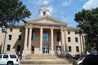
Pitt County is a county located in the Inner Banks region of the U.S. state of North Carolina. As of the 2020 census, the population was 170,243, making it the 14th-most populous county in North Carolina. Its county seat is Greenville.

<span class="mw-page-title-main">Madison County, North Carolina</span> County in North Carolina, United States

Madison County is a county located in the U.S. state of North Carolina. As of the 2020 census, the population was 21,193. Its county seat is Marshall. Madison County is part of the Asheville, NC Metropolitan Statistical Area.

<span class="mw-page-title-main">Lenoir County, North Carolina</span> County in North Carolina, United States

Lenoir County is a county in the U.S. state of North Carolina. As of the 2020 census, its population was 55,122. Its county seat is Kinston, located on the Neuse River, across which the county has its territory.

<span class="mw-page-title-main">Greene County, North Carolina</span> County in North Carolina, United States

Greene County is a county located in the U.S. state of North Carolina. As of the 2020 census, the population was 20,451. Its county seat is Snow Hill.

Beulaville is a town located in Duplin County, North Carolina, United States. As of the 2020 census, the population was 1,116. At the previous census in 2010, the population was 1,296. The community lies within the Limestone Creek Township.

<span class="mw-page-title-main">Hookerton, North Carolina</span> Town in North Carolina, United States

Hookerton is a town in Greene County, North Carolina, United States. The population was 409 at the 2010 census. It is geographically located southeast of Snow Hill on North Carolina Highway 123. The town is part of the Greenville Metropolitan Area.

<span class="mw-page-title-main">Walstonburg, North Carolina</span> Town in North Carolina, United States

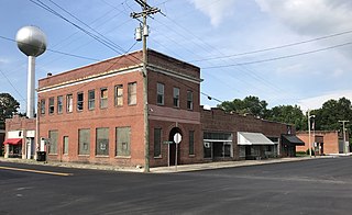
Walstonburg is a town in Greene County, North Carolina, United States. The population was 219 at the 2010 census. It is located north of Snow Hill on North Carolina Highway 91. The town is part of the Greenville Metropolitan Area.

<span class="mw-page-title-main">Kinston, North Carolina</span> City in North Carolina, United States

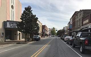
Kinston is a city in Lenoir County, North Carolina, United States, with a population of 19,900 as of the 2020 census. It has been the county seat of Lenoir County since its formation in 1791. Kinston is located in the coastal plains region of eastern North Carolina.

<span class="mw-page-title-main">Bethel, North Carolina</span> Town in North Carolina, United States

Bethel is a town in Pitt County, North Carolina, United States. The population was 1,577 at the 2010 census. The town is a part of the Greenville Metropolitan Area located in North Carolina's Inner Banks region. Confusingly, there are three other towns in the state named "Bethel." One is between Edenton and Hertford in the "Finger Counties" region in the northeastern corner of the state, another is in the north-central part, in Caswell County and the third is located in the Mountain Region of North Carolina, in Haywood County. There is also a community named Bethel located in Watauga County.

<span class="mw-page-title-main">Farmville, North Carolina</span> Town in North Carolina, United States

Farmville is a town in Pitt County, North Carolina, United States, eight miles to the west of Greenville. At the 2010 Census, the population was 4,654. Farmville is a part of the Greenville Metropolitan Area located in North Carolina's Inner Banks region. Farmville has been a Tree City USA community through the Arbor Day Foundation for 36 years, proving its commitment to managing and expanding its public trees. The Town government, in cooperation with other non-profit groups that work for the advancement of the town, sponsor annual events such as the Farmville Dogwood Festival, the Christmas Parade, Independence Day Celebration, A Taste of Farmville, and the Holiday Open House, among others.

Eureka is a town in Wayne County, North Carolina, United States. The population was 197 at the 2010 census. It is included in the Goldsboro, North Carolina Metropolitan Statistical Area.

<span class="mw-page-title-main">Fremont, North Carolina</span> Town in North Carolina, United States

Fremont is a town in Wayne County, North Carolina, United States. The population was 1,255 at the 2010 census. It is included in the Goldsboro, North Carolina Metropolitan Statistical Area.

<span class="mw-page-title-main">Goldsboro, North Carolina</span> City in North Carolina, United States

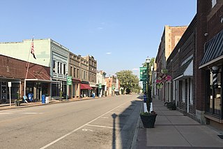
Goldsboro, originally Goldsborough, is a city in and the county seat of Wayne County, North Carolina, United States. The population was 33,657 at the 2020 census. It is the principal city of and is included in the Goldsboro, North Carolina Metropolitan Statistical Area. The nearby town of Waynesboro was founded in 1787, and Goldsboro was incorporated in 1847. It is the county seat of Wayne County.

Walnut Creek is a village in Wayne County, North Carolina, United States. The population was 835 in 2010. It is included in the Goldsboro, North Carolina Metropolitan Statistical Area.

<span class="mw-page-title-main">Grifton, North Carolina</span> Town in North Carolina, United States

Grifton is a town in Lenoir and Pitt counties, North Carolina, United States. The population was 2,617 at the 2010 census. The Pitt County portion of the town is a part of the Greenville Metropolitan Statistical Area located in North Carolina's Inner Banks region.

<span class="mw-page-title-main">Mount Olive, North Carolina</span> Town in North Carolina, United States

Mount Olive is a town in Duplin and Wayne counties in the U.S. state of North Carolina. The population was 4,589 at the 2010 census. It is included in the Goldsboro, North Carolina Metropolitan Statistical Area. The town is home to the Mt. Olive Pickle Company and the University of Mount Olive.

<span class="mw-page-title-main">U.S. Route 13 in North Carolina</span> Highway in North Carolina

U.S. Route 13 (US 13) is a United States Numbered Highway running from Eastover, North Carolina to Morrisville, Pennsylvania. In North Carolina, it runs along a northeast–southwest alignment for 189.1 miles (304.3 km) connecting the cities of Fayetteville, Goldsboro, Greenville, Williamston, and Ahoskie. The southern terminus is located at Interstate 95 (I-95) and I-295 near Eastover. From the terminus, US 13 travels along a northeastern–southwestern alignment through Newton Grove to US 117 in Mar-Mac. US 13 runs concurrently along US 117 north to Goldsboro, where it also shares a brief concurrency with US 70. The highway continues northeastward to Greenville and then turns to the north until reaching US 64 near Bethel. US 13 and US 64 run concurrently to the east until Williamston where US 13 diverges to the north, concurrent with US 17. In Windsor, US 13 diverges from US 17 and runs northward through Ahoskie. US 13 turns to the northeast near Winton and continues in that direction until reaching the Virginia state line near Gates.

<span class="mw-page-title-main">North Carolina Highway 123</span> State highway in Greene County, North Carolina, US

North Carolina Highway 123 (NC 123) is a primary state highway in the U.S. state of North Carolina. It serves as the main road through Hookerton and an alternate bypass of Snow Hill, entirely in Greene County.

References

Notes
  1. 1 2 3 "North Carolina Gazetteer" . Retrieved December 19, 2022.
  2. "ArcGIS REST Services Directory". United States Census Bureau. Retrieved September 20, 2022.
  3. 1 2 U.S. Geological Survey Geographic Names Information System: Snow Hill, North Carolina
  4. 1 2 "U.S. Census website". United States Census Bureau . Retrieved January 31, 2008.
  5. 1 2 "Geographic Identifiers: 2010 Demographic Profile Data (G001): Snow Hill town, North Carolina". American Factfinder. U.S. Census Bureau. Retrieved January 6, 2017.[ dead link ]
  6. "Find a County". National Association of Counties. Retrieved June 7, 2011.
  7. Town of Snow Hill in Greene County, North Carolina: History of Snow Hill, NC
  8. Holaday, Chris. Professional Baseball in North Carolina: An Illustrated City-by-city History, 1901-1996. Jefferson, N.C.: McFarland. ISBN   978-0786425532.
  9. "National Register Information System". National Register of Historic Places . National Park Service. July 9, 2010.
  10. "Census of Population and Housing". Census.gov. Retrieved June 4, 2015.
  11. "Explore Census Data". data.census.gov. Retrieved December 24, 2021.
  12. Greene County Schools Archived May 27, 2012, at the Wayback Machine
  13. Meet | Don Davis. Retrieved July 25, 2020.