Oxford, North Carolina

Last updated

Oxford, North Carolina
Oxford, North Carolina.jpg
Main Street
Oxford, NC Town Flag.gif
Oxford, NC Town Seal.jpg
Motto(s): 
"Historic, Walkable, Friendly"
NCMap-doton-Oxford.PNG
Location of Oxford, North Carolina
Coordinates: 36°18′56″N78°35′05″W / 36.31556°N 78.58472°W / 36.31556; -78.58472
CountryUnited States
State North Carolina
County Granville
Founded1811
Incorporated1816
Named for A plantation owned by Samuel Benton [1]
Government
   Mayor Jackie Sergent (Ind.)
Area
[2]
  Total6.24 sq mi (16.15 km2)
  Land6.23 sq mi (16.14 km2)
  Water0.00 sq mi (0.01 km2)
Elevation
[3]
449 ft (137 m)
Population
 (2020)
  Total8,628
  Density1,384.47/sq mi (534.54/km2)
Time zone UTC−5 (Eastern (EST))
  Summer (DST) UTC−4 (EDT)
ZIP code
27565
Area code 919
FIPS code 37-49800 [4]
GNIS feature ID2404455 [3]
Website www.oxfordnc.org

Oxford is a town in Granville County, North Carolina, United States, with a population of 8,628 as of the 2020 census. [5] It is the county seat of Granville County. [6]

Contents

History

The town's history dates to 1761, when local legislator Samuel Benton built a plantation home and called it "Oxford." The legislature ordered the area around his plantation to be the seat of Granville County. The town was not incorporated until 1816. [7]

The first Masonic orphanage for children in the United States was built in Oxford. It was originally established as St. John's College in 1858. The college ceased operations shortly after opening, however. In 1872 the community decided that the property should be repurposed to educate disadvantaged populations. In December 1873 the first residents were admitted to the Oxford Orphans Asylum, which is today known as the "Masonic Home for Children at Oxford." [8]

In 1851 James H. Horner established Horner Military School, [9] which enrolled many young men from New York, Pennsylvania, Virginia, South Carolina and other states. Many of the students went on to become leaders in the United States government, such as James Crawford Biggs, Solicitor General under President Franklin D. Roosevelt at the inception of the New Deal. After the barracks were destroyed by a fire in 1913, the school relocated to Charlotte, North Carolina. [10]

The Oxford Female College was established in 1850 by North Carolina Baptists. After suffering financial difficulties, the college was sold and became a private educational institution renamed "Oxford Female Seminary." In 1880 F. P. Hobgood took over leadership of the school, and it gained popularity under his leadership. The school closed in 1925, following Hobgood's death the previous year. [11]

Oxford c. 1925 Oxford, North Carolina in 1925.jpg
Oxford c. 1925

In 1883 the state legislature established the Colored Orphan Asylum in Oxford. Henry Plummer Cheatham, a former U.S. congressman (1889-1893), was appointed as superintendent in the early 1900s and led the institution for 28 years.

In 1970, Henry Marrow was shot and killed in Oxford. The killing resulted in a racial protest. The events were chronicled by Timothy Tyson in the book Blood Done Sign My Name (2004) and a 2010 movie with the same name.

A Confederate statue was erected in 1909 by the Granville Grays United Daughters of the Confederacy at a cost of $3000.00 and valued in 2009 at $1,327,791.62. The monument was erected in the courthouse square facing away from the courthouse. The base, constructed of granite from Warren County, is 27 feet (8.2 m) tall, and the bronze statue is 7 feet (2.1 m) tall. The monument, a memorial to the Confederate veterans of Granville County that served in the Civil War in the Granville Grays Company D, 12th Regiment, was dedicated October 30, 1909. The statue had not arrived in time but the ceremony continued and the statue was placed at a later date. [12]

Following the 1970 Oxford protests, the city moved the monument from the courthouse square to a site in front of the Richard H. Thornton Library. Since 2009, some activists had suggested moving it to an historic graveyard located down the street. [13] In June 2020 the statue was removed and is currently in storage. [14]

The Central Orphanage, Granville County Courthouse, Joseph B. Littlejohn House, Locust Lawn, Oxford Historic District, Paschall-Daniel House, Archibald Taylor Plantation House, and Thorndale are listed on the National Register of Historic Places. [15]

Geography

Interstate 85 crosses the southeastern edge of the town, with access from Exits 202, 204, and 206; I-85 leads southwest 29 miles (47 km) to Durham and northeast 100 miles (160 km) to Petersburg, Virginia. U.S. Route 15 passes through the center of Oxford as Lewis Street, Hillsboro Street, and College Street, leading southwest 14 miles (23 km) to Creedmoor and north 23 miles (37 km) to Clarksville, Virginia. U.S. Route 158 bypasses Oxford on the northern side, leading east 12 miles (19 km) to Henderson and west 25 miles (40 km) to Roxboro.

According to the United States Census Bureau, Oxford has a total area of 6.1 square miles (15.7 km2), all land. [16]

Oxford contains three voting precincts in Granville County: Credle, East Oxford, and South Oxford.

Demographics

Historical population
CensusPop.Note
1850 669
1860 87831.2%
1870 9164.3%
1880 1,34947.3%
1890 2,907115.5%
1900 2,059−29.2%
1910 3,01846.6%
1920 3,60619.5%
1930 4,10113.7%
1940 3,991−2.7%
1950 6,68567.5%
1960 6,9784.4%
1970 7,1782.9%
1980 7,7097.4%
1990 7,9132.6%
2000 8,3385.4%
2010 8,4611.5%
2020 8,6282.0%
2021 (est.)8,775 [17] 1.7%
U.S. Decennial Census [18]

2020 census

Oxford racial composition [5]
RaceNumberPercentage
White (non-Hispanic)3,00634.84%
Black or African American (non-Hispanic)4,68554.30%
Native American 170.20%
Asian 861.00%
Pacific Islander 30.03%
Other/Mixed 2693.12%
Hispanic or Latino 5626.51%

As of the 2020 United States census, there were 8,628 people, 3,454 households, and 2,235 families residing in the city.

2010 census

As of the census of 2010, there were 8,461 people in 3,410 households in the town. The population density was 1,880.2 inhabitants per square mile (725.9/km2). There were 3,771 housing units at an average density of 838.0 per square mile (323.6/km2). The racial composition of the town was: 55.6% Black or African American, 38.6% White, 1.1% Asian American, 0.4% Native American, 2.5% Other, and 1.8% two or more races. 4.8% of the population identified as Hispanic or Latino American

There were 3,410 households, out of which 26.3% had children under the age of 18 living with them. The average household size was 2.48. In the town, the age distribution of the population was spread out, with 23.4% under the age of 18, 8.8% from 18 to 24, 10.6% from 25 to 34, 18.1% from 35 to 49, 19.7% from 50 to 64, and 19.4% who were 65 years of age or older. For every 100 females, there were 79.4 males.

The median income [19] for a household in the town was $32,050 and the mean income was $48,293. The median and mean income for a family was $49,787 and $62,355, respectively. The per capita income for the town was $20,729. About 16.9% of families were at or below the poverty line, including 38.6% of those under age 18 and 19.3% of those age 65 or over. Of the total town population, 20.6% were at or below the poverty line.

Economy

Oxford is home to Revlon's largest manufacturing facility, as well as its IT/IS department. CertainTeed has a roofing supplies plant in the city, Bailey Farms Inc Chile Pepper Grower & Distributor, Macra Lace Textiles, Shalag nonwoven hygienic fabrics, Gate Precast Concrete, Ideal Zipper, AWNC Toyota transmission manufacturing, Masonic Home for Children, and Biofuels Center of North Carolina are located in Oxford.

Notable people

Schools

Related Research Articles

<span class="mw-page-title-main">Montgomery County, North Carolina</span> County in North Carolina, United States

Montgomery County is a rural county located in the southern Piedmont of the U.S. state of North Carolina. As of the 2020 census, the population was 25,751. Its county seat is Troy.

<span class="mw-page-title-main">Talbot County, Maryland</span> County in Maryland, United States

Talbot County is located in the heart of the Eastern Shore of Maryland in the U.S. state of Maryland. As of the 2020 census, the population was 37,526. Its county seat is Easton. The county was named for Lady Grace Talbot, the wife of Sir Robert Talbot, an Anglo-Irish statesman, and the sister of Lord Baltimore.

<span class="mw-page-title-main">Warren County, North Carolina</span> County in North Carolina, United States

Warren County is a county located in the northeastern Piedmont region of the U.S. state of North Carolina, on the northern border with Virginia, made famous for a landfill and birthplace of the environmental justice movement. As of the 2020 census, its population was 18,642. Its county seat is Warrenton. It was a center of tobacco and cotton plantations, education, and later textile mills.

<span class="mw-page-title-main">Person County, North Carolina</span> County in North Carolina, United States

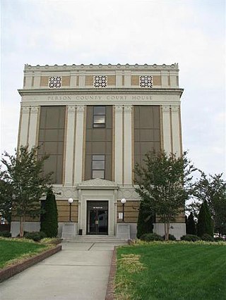
Person County is a county located in the U.S. state of North Carolina. The population was 39,097 as of the 2020 census. The county seat is Roxboro.

<span class="mw-page-title-main">Iredell County, North Carolina</span> County in North Carolina, United States

Iredell County is a county located in the U.S. state of North Carolina. As of the 2020 census, the population was 186,693. Its county seat is Statesville, and its largest community is Mooresville. The county was formed in 1788, subtracted from Rowan County. It is named for James Iredell, one of the first justices of the Supreme Court. Iredell County is included in the Charlotte-Concord-Gastonia, NC-SC Metropolitan Statistical Area, as defined by the Office of Management and Budget with data from the U.S. Census Bureau.

<span class="mw-page-title-main">Halifax County, North Carolina</span> County in North Carolina, United States

Halifax County is a county located in the U.S. state of North Carolina. As of the 2020 census, the population was 48,622. Its county seat is Halifax.

<span class="mw-page-title-main">Granville County, North Carolina</span> County in North Carolina, United States

Granville County is a county located on the northern border of the U.S. state of North Carolina. As of the 2020 census, the population was 60,992. Its county seat is Oxford.

<span class="mw-page-title-main">Franklin County, North Carolina</span> County in North Carolina, United States

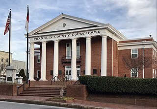
Franklin County is a county located in the U.S. state of North Carolina. As of the 2020 census, the population was 68,573. Its county seat is Louisburg.

<span class="mw-page-title-main">Edgecombe County, North Carolina</span> County in North Carolina, United States

Edgecombe County is a county located in the U.S. state of North Carolina. As of the 2020 census, the population was 48,900. Its county seat is Tarboro.

<span class="mw-page-title-main">Morgantown, Kentucky</span> City in Kentucky, United States

Morgantown is a home rule-class city in, and the seat of Butler County, Kentucky, United States. The population was 2,471 at the time of the 2020 Census.

<span class="mw-page-title-main">Pittsboro, North Carolina</span> Town in North Carolina, United States

Pittsboro is a town in Chatham County, North Carolina, United States. The population was 3,743 at the 2010 census and 4,537 at the 2020 census. It is the county seat of Chatham County.

<span class="mw-page-title-main">Shelby, North Carolina</span> City in North Carolina, United States

Shelby is a city in and the county seat of Cleveland County, North Carolina. It lies near the western edge of the Charlotte-Concord, NC-SC Combined Statistical Area. The population was 21,918 at the 2020 census.

<span class="mw-page-title-main">Robbinsville, North Carolina</span> Town in North Carolina, United States

Robbinsville is a town in Graham County, North Carolina, United States. The population was 597 at the 2020 census. It is the county seat of Graham County, county population 8,030.

<span class="mw-page-title-main">Butner, North Carolina</span> Town in North Carolina, United States

Butner is a town in Granville County, North Carolina, United States. The population was 8,397 as of the 2020 census. Butner was managed by the state of North Carolina from 1947 through 2007.

<span class="mw-page-title-main">Creedmoor, North Carolina</span> City in North Carolina, United States

Creedmoor is a city in Granville County, North Carolina, United States. The population was 4,124 at the 2010 census.

<span class="mw-page-title-main">Marshall, North Carolina</span> Town in North Carolina, United States

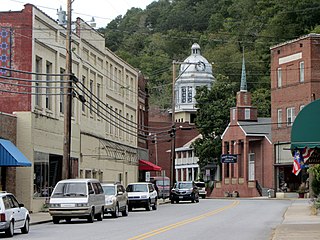
Marshall is a town in Madison County, North Carolina, United States. The population was 872 at the 2010 census. It is the county seat of Madison County.

<span class="mw-page-title-main">Hillsborough, North Carolina</span> Town in North Carolina, United States

The town of Hillsborough is the county seat of Orange County, North Carolina, United States and is located along the Eno River. The population was 6,087 in 2010, but it grew rapidly to 9,660 by 2020.

<span class="mw-page-title-main">Laurinburg, North Carolina</span> City in North Carolina, United States

Laurinburg is a city in and the county seat of Scotland County, North Carolina, United States. Located in southern North Carolina near the South Carolina border, Laurinburg is southwest of Fayetteville and is home to St. Andrews University. The population at the 2010 census was 15,962 people.

<span class="mw-page-title-main">Danbury, North Carolina</span> City in North Carolina, United States

Danbury is a city located in Danbury Township, Stokes County, North Carolina, United States. As of the 2020 census, the city had a total population of 142. It is the county seat of Stokes County. Danbury is located on North Carolina Highway 8/89 approximately 20 miles (32 km) north of Winston-Salem and is the "Gateway to Hanging Rock". The Stokes County Government Center, Arts Council, school board, county jail, a public library, a post office, and other public services are found within the town limits. LifeBrite Community Hospital of Stokes is located about a half mile northwest of the town. North Stokes High School, a big part of town, is located 7.4 miles to the northwest.

References

  1. "North Carolina Gazetteer" . Retrieved November 25, 2023.
  2. "ArcGIS REST Services Directory". United States Census Bureau. Retrieved September 20, 2022.
  3. 1 2 U.S. Geological Survey Geographic Names Information System: Oxford, North Carolina
  4. "U.S. Census website". United States Census Bureau . Retrieved January 31, 2008.
  5. 1 2 "Explore Census Data". data.census.gov. Retrieved December 23, 2021.
  6. "Find a County". National Association of Counties. Retrieved June 7, 2011.
  7. "Granville County History: Oxford in Context". City of Oxford. Retrieved January 6, 2017.
  8. "The Masonic Home for Children at Oxford". Masonic Home for Children at Oxford. Retrieved January 6, 2017.
  9. "Horner Military School, Oxford, N.C." North Carolina Digital Collections. State Archives of North Carolina. Retrieved June 9, 2022.
  10. Anderson, Jean B. (2006). "Horner School". In Powell, William S. (ed.). Encyclopedia of North Carolina. Chapel Hill: University of North Carolina Press.
  11. "Oxford College". www.ncpedia.org.
  12. Conn, Edward L (1909). "Confederate statue". Orphanage Press, Oxford, NC. p. 5. Retrieved August 17, 2014.
  13. West, William F. (July 9, 2009). "Oxford NC Confederate Monument Under Attack". Southern Heritage 411. Retrieved August 17, 2014.
  14. "Granville County Confederate Monument, Oxford". docsouth.unc.edu. UNC University Library. March 19, 2010. Retrieved June 9, 2022.
  15. "National Register Information System". National Register of Historic Places . National Park Service. July 9, 2010.
  16. "Geographic Identifiers: 2010 Demographic Profile Data (G001): Oxford town, North Carolina". American Factfinder. U.S. Census Bureau. Retrieved January 6, 2017.[ dead link ]
  17. "QuickFacts Oxford city, North Carolina". United States Census Bureau. Retrieved May 27, 2022.
  18. "Census of Population and Housing". Census.gov. Retrieved June 4, 2016.
  19. US Census FactFinder Archived 2020-02-16 at archive.today Retrieved 2011-11-15
  20. Rascoe, Ayesha (October 16, 2022). "How a Black man's 1970 murder spurred change in rural North Carolina". NPR.