Davidson County, North Carolina

Last updated

Davidson County
Davidson County NC Courthouse.jpg
Davidson County Courthouse in Lexington
Davidson County Flag.gif
Davidson County nc seal.jpg
Davidson County Logo.png
Map of North Carolina highlighting Davidson County.svg
Location within the U.S. state of North Carolina
North Carolina in United States.svg
North Carolina's location within the U.S.
Coordinates: 35°48′N80°13′W / 35.80°N 80.21°W / 35.80; -80.21
CountryFlag of the United States.svg United States
StateFlag of North Carolina.svg  North Carolina
Founded1822
Named for William Lee Davidson
Seat Lexington
Largest community Thomasville
Area
  Total567.70 sq mi (1,470.3 km2)
  Land553.18 sq mi (1,432.7 km2)
  Water14.52 sq mi (37.6 km2)  2.56%
Population
 (2020)
  Total168,930
  Estimate 
(2023)
174,804
  Density305.38/sq mi (117.91/km2)
Time zone UTC−5 (Eastern)
  Summer (DST) UTC−4 (EDT)
Congressional district 8th
Website www.co.davidson.nc.us

Davidson County is a county located in the U.S. state of North Carolina. As of the 2020 census, the population was 168,930. [1] Its county seat is Lexington, [2] and its largest community is Thomasville.

Contents

Davidson County is included in the Winston-Salem, NC Metropolitan Statistical Area, which is also included in the Greensboro–Winston-Salem–High Point, NC Combined Statistical Area.

Parts of Davidson County are in the Yadkin Valley AVA.

History

Old Davidson County Courthouse in Lexington Old Davidson County Courthouse 1.png
Old Davidson County Courthouse in Lexington

The original North Carolina county of this name was created in 1786 what was then the far western portion of North Carolina, with its county seat at Nashville and a territory covering most of what is now Middle Tennessee. When Tennessee was established as a separate state in 1796, this county became Davidson County, Tennessee.

The current North Carolina county was formed in 1822 from Rowan County. It was named after Brigadier General William Lee Davidson, an American Revolutionary War general killed at the Battle of Cowan's Ford on the Catawba River in 1781. [3] [4]

In 1911, a new county called Piedmont County was proposed, with High Point as its county seat, to be created from Guilford, Davidson and Randolph Counties. Many people appeared at the Guilford County courthouse to oppose the plan, vowing to go to the state legislature to protest. The state legislature voted down the plan in February 1911. [5] [6]

Geography

Davidson County, North Carolina
Interactive map of Davidson County

According to the U.S. Census Bureau, the county has a total area of 567.70 square miles (1,470.3 km2), of which 553.18 square miles (1,432.7 km2) is land and 14.52 square miles (37.6 km2) (2.56%) is water. [7]

Davidson County is located entirely within the Piedmont region of central North Carolina. The Piedmont consists of gently rolling terrain frequently broken by hills or shallow valleys formed by rivers and streams. An exception to this terrain are the Uwharrie Mountains in the county's western and southwestern sections. The Uwharries are the oldest mountain range in North America, [8] and at one time they rose to nearly 20,000 feet (6,100 m) above sea level. However, time has worn them down to little more than high hills; yet due to the relative flatness of the surrounding countryside they still rise from 250 to 500 feet (150 m) above their base. The highest point in the Uwharries - and the highest point in Davidson County - is High Rock Mountain in the county's southwestern corner. It has an elevation of 1,119 feet (341 m) above sea level.

National protected area

State and local protected areas

Major water bodies

Adjacent counties

Major highways

Major infrastructure

Demographics

Historical population
CensusPop.Note
1830 13,389
1840 14,6069.1%
1850 15,3204.9%
1860 16,6018.4%
1870 17,4144.9%
1880 20,33316.8%
1890 21,7026.7%
1900 23,4037.8%
1910 29,40425.6%
1920 35,20119.7%
1930 47,86536.0%
1940 53,37711.5%
1950 62,24416.6%
1960 79,49327.7%
1970 95,62720.3%
1980 113,16218.3%
1990 126,67711.9%
2000 147,24616.2%
2010 162,87810.6%
2020 168,9303.7%
2023 (est.)174,804 [1] 3.5%
U.S. Decennial Census [12]
1790–1960 [13] 1900–1990 [14]
1990–2000 [15] 2010 [16] 2020 [1]

2020 census

Davidson County racial composition [17]
RaceNumberPercentage
White (non-Hispanic)129,48776.65%
Black or African American (non-Hispanic)15,8399.38%
Native American 6650.39%
Asian 2,4401.44%
Pacific Islander 430.03%
Other/Mixed 6,5543.88%
Hispanic or Latino 13,9028.23%

As of the 2020 census, there were 168,930 people, 69,938 households, and 49,037 families residing in the county.

2010 census

At the 2010 census, [18] there were 149,331 people, 58,156 households, and 42,512 families residing in the county. The population density was 267 people per square mile (103 people/km2). There were 62,432 housing units at an average density of 113 units per square mile (44 units/km2). The racial makeup of the county was 84.05% White, 11.14% Black or African American, 0.37% Native American, 0.82% Asian, 0.01% Pacific Islander, 1.66% from other races, and 0.94% from two or more races. 3.24% of the population were Hispanic or Latino of any race.

There were 58,156 households, out of which 32.70% had children under the age of 18 living with them, 58.00% were married couples living together, 10.80% had a female householder with no husband present, and 26.90% were non-families. 22.90% of all households were made up of individuals, and 8.80% had someone living alone who was 65 years of age or older. The average household size was 2.50 and the average family size was 2.92.

In the county, the population was spread out, with 24.30% under the age of 18, 7.60% from 18 to 24, 31.20% from 25 to 44, 24.10% from 45 to 64, and 12.80% who were 65 years of age or older. The median age was 37 years. For every 100 females there were 96.00 males. For every 100 females age 18 and over, there were 93.70 males.

The median income for a household in the county was $38,640, and the median income for a family was $46,241. Males had a median income of $31,287 versus $23,622 for females. The per capita income for the county was $18,703. About 7.00% of families and 10.10% of the population were below the poverty line, including 13.30% of people under age 18 and 12.10% of those age 65 or over.

Government and politics

Davidson County Governmental Center in Lexington Davidson County NC Governmental Center.jpg
Davidson County Governmental Center in Lexington

Davidson County was one of the first areas of North Carolina to turn Republican, doing so long before other areas of conservative white voters shifted away from the Democrats. No Democratic presidential nominee has carried the county since Franklin D. Roosevelt defeated Thomas E. Dewey by a mere ten votes out of almost 19,000 in 1944. It was one of only 13 counties out of 100 in the state to vote for Barry Goldwater over Lyndon Johnson in 1964, and the last Democrat to garner even one-third of the county's vote was Jimmy Carter in 1980.

United States presidential election results for Davidson County, North Carolina [19] [20]
Year Republican Democratic Third party
No.%No.%No.%
2020 64,65873.05%22,63625.57%1,2201.38%
2016 54,31772.56%18,10924.19%2,4303.25%
2012 49,38369.62%20,62429.07%9281.31%
2008 45,41966.23%22,43332.71%7291.06%
2004 42,07570.72%17,19128.89%2300.39%
2000 35,38767.99%16,19931.12%4610.89%
1996 24,79758.75%13,59332.21%3,8179.04%
1992 24,86950.01%16,46233.11%8,39416.88%
1988 28,37468.11%13,21531.72%730.18%
1984 30,47172.55%11,46927.31%610.15%
1980 22,79459.56%14,57938.10%8962.34%
1976 18,81351.05%17,85948.46%1830.50%
1972 24,87574.79%7,69123.12%6962.09%
1968 16,67846.57%7,59421.20%11,54432.23%
1964 17,29255.73%13,73544.27%00.00%
1960 18,79758.90%13,11841.10%00.00%
1956 16,17861.83%9,98738.17%00.00%
1952 14,29956.67%10,93143.33%00.00%
1948 8,53949.32%7,99146.15%7844.53%
1944 9,44549.97%9,45550.03%00.00%
1940 6,97838.63%11,08461.37%00.00%
1936 7,65641.38%10,84458.62%00.00%
1932 6,05139.04%9,29259.95%1571.01%
1928 8,96063.19%5,22036.81%00.00%
1924 6,22748.69%6,50750.88%560.44%
1920 5,96055.41%4,79744.59%00.00%
1916 2,80151.04%2,67548.74%120.22%
1912 1,50929.26%2,48448.16%1,16522.59%
1908 2,34052.12%2,12647.35%240.53%
1904 2,05450.11%2,01749.21%280.68%
1900 2,32955.49%1,82343.44%451.07%
1896 2,37553.00%2,07246.24%340.76%
1892 1,83742.97%1,92845.10%51011.93%
1888 2,34652.53%2,02345.30%972.17%
1884 2,09752.46%1,90047.54%00.00%
1880 1,86451.00%1,78148.73%100.27%

Davidson County is a member of the regional Piedmont Triad Council of Governments.

Davidson County gained national attention when Gerald Hege, Sheriff from 1994 to 2003, became a minor celebrity for his unconventional prisoner treatment methods.

County Commissioners

Office [21] HolderPartyTerm expires
County Commissioner (chair)Todd YatesRepublican2024
County Commissioner (vice-chair)James ShoresRepublican2024
County CommissionerChris ElliottRepublican2026
County CommissionerFred McClureRepublican2024
County CommissionerMatt MizellRepublican2026
County CommissionerSteve ShellRepublican2026
County CommissionerKaren WatfordRepublican2026

Education

Davidson County is served by Davidson County Schools; however, the cities of Thomasville and Lexington have their own school districts. Davidson County Schools is one of the county's largest employers.

Davidson County is also served by Davidson-Davie Community College, a comprehensive community college that is a member school of the North Carolina Community College System. Davidson-Davie Community College was chartered in 1958 as an Industrial Education Center designed to provide adults with the education and skills needed to move from an agricultural to a manufacturing-based economy.

In 1965, the institution was chartered as Davidson County Community College. The Associate in Arts and Associate in Science degrees were added to the existing Associate in Applied Science degree, Diploma, and Certificate programs. University transfer courses were added in 1966. In 1997, the college participated in the Comprehensive Articulation Agreement (CAA) that allows college transfer students to move easily to the 16 UNC schools, as well as many independent college and universities. Presently the Davidson Campus has grown to 11 buildings and two emergency services training facilities on approximately 97 acres (390,000 m2).

Attractions

Arts United of Davidson County Lexington NC Arts United of Davidson County.jpg
Arts United of Davidson County

Festivals

One of the county's most famous attractions is the yearly Lexington Barbecue Festival, held in the city of Lexington during the month of October, bringing in over 100,000 visitors from all over the southeastern U.S. There is also a yearly Davidson County Agriculture Fair held in September. Thomasville hosts an annual "Everybody's Day Festival", [22] the longest running festival in the state. The "Southeastern Old Threshers Reunion" [23] is held every year at the Denton Farmpark.

Landmarks

There are many year-long attractions in Davidson County. Some of which include Historic Uptown Lexington, which consists of the Davidson County Historical Museum located in the old courthouse. Alongside the Yadkin River sits Boone's Cave Park where according to legend, a young Daniel Boone and his family once lived. Other attractions include Denton Farm Park, Walter Johnson Camp and Conference Center, and the North Carolina Vietnam Veterans Memorial. The historic Wil-Cox Bridge spanning the Yadkin River has been preserved for pedestrian traffic and is now part of the Yadkin River Park. The Big Chair in Thomasville is also a major landmark.

Art

Pigs on Parade during the Lexington Barbecue Festival Lexington Barbecue Festival - more pigs.jpg
Pigs on Parade during the Lexington Barbecue Festival

Pigs in the City is an art initiative held each summer in Lexington, and attracts tens of thousands of visitors.

In 2005, Davidson County Community College and the City of Thomasville formed a partnership for the creation of the Thomasville Artisan Center. This art studio allowed the college to reinvigorate its Associate in Fine Arts Degree and offer both university transfer classes as well as adult community interest classes in painting, drawing, and sculpting. The Artisan Center is part of the college's Thomasville Education Center complex which is part of the college's outreach to the community. The college has a second campus in Davie County in the city of Mocksville, as well as the Uptown Lexington Education Center, located within a few blocks of the Arts Center of Davidson County and the historic Court House.

Barbecue

One of the two major styles of North Carolina barbecue originated in Lexington, the county seat and home to the annual Lexington Barbecue Festival. Therefore, many Lexington-style barbecue restaurants are found throughout the county.

Richard Childress

Davidson County is home to many supporting race fans and the famous Richard Childress. It includes his personal Childress Vineyards and Richard Childress Racing Museum.

The Big Chair

Davidson County is also known for its oversized chair, "The Big Chair." This chair is located in central Thomasville and is a symbol of Davidson County's furniture industry.

High Rock Lake

High Rock Lake Abbottscreek.jpg
High Rock Lake

High Rock Lake is the northernmost of the Uwharrie Lakes and the second largest lake in North Carolina behind Lake Norman. Its water surface covers 15,180 acres (61.4 km2) and there are 365 miles (587 km) of shoreline. It begins at the confluence of the Yadkin River and the South Yadkin River. It has been the host of the Bassmaster Classic in 1994, 1995 and 1998. [24] and is the site of frequent other local angling competitions. Lexington is just north of the Abbotts Creek section of the lake.

Communities

Map of Davidson County with municipal and township labels Map of Davidson County North Carolina With Municipal and Township Labels.PNG
Map of Davidson County with municipal and township labels

Cities

Towns

Townships

Census-designated places

Unincorporated communities

Notable people

See also

Related Research Articles

<span class="mw-page-title-main">Montgomery County, North Carolina</span> County in North Carolina, United States

Montgomery County is a rural county located in the southern Piedmont of the U.S. state of North Carolina. As of the 2020 census, the population was 25,751. Its county seat is Troy.

<span class="mw-page-title-main">Yadkin County, North Carolina</span> County in North Carolina, United States

Yadkin County is located in the U.S. state of North Carolina. As of the 2020 census, the population was 37,214. Its county seat is Yadkinville. Yadkin County is included in the Winston-Salem, NC Metropolitan Statistical Area, which is also included in the Greensboro–Winston-Salem–High Point, NC Combined Statistical Area.

<span class="mw-page-title-main">Union County, North Carolina</span> County in North Carolina, United States

Union County is a county located in the U.S. state of North Carolina. As of the 2020 census, the population was 238,267. Its county seat is Monroe. Union County is included in the Charlotte-Concord-Gastonia, NC-SC Metropolitan Statistical Area.

<span class="mw-page-title-main">Surry County, North Carolina</span> County in North Carolina, United States

Surry County is a county located in the U.S. state of North Carolina. As of the 2020 census, the population was 71,359. Its county seat is Dobson, and its largest community is Mount Airy.

<span class="mw-page-title-main">Stokes County, North Carolina</span> County in North Carolina, United States

Stokes County is a county located in the U.S. state of North Carolina. As of the 2020 census, the population was 44,520. Its county seat is Danbury.

<span class="mw-page-title-main">Stanly County, North Carolina</span> County in North Carolina, United States

Stanly County is a county in the U.S. state of North Carolina. As of the 2020 census, the population was 62,504. Its county seat is Albemarle.

<span class="mw-page-title-main">Rowan County, North Carolina</span> County in North Carolina, United States

Rowan County is a county in the U.S. state of North Carolina that was formed in 1753, as part of the British Province of North Carolina. It was originally a vast territory with unlimited western boundaries, but its size was reduced to 524 square miles (1,360 km2) after several counties were formed from Rowan County in the 18th and 19th centuries. As of the 2020 census, its population was 146,875. Its county seat, Salisbury, is the oldest continuously populated European-American town in the western half of North Carolina. Rowan County is located northeast of Charlotte, and is considered part of the Charlotte-Concord-Gastonia, NC-SC Metropolitan Statistical Area.

<span class="mw-page-title-main">Randolph County, North Carolina</span> County in North Carolina, United States

Randolph County is a county located in the U.S. state of North Carolina. As of the 2020 census, the population was 144,171. Its county seat is Asheboro.

<span class="mw-page-title-main">Iredell County, North Carolina</span> County in North Carolina, United States

Iredell County is a county located in the U.S. state of North Carolina. As of the 2020 census, the population was 186,693. Its county seat is Statesville, and its largest community is Mooresville. The county was formed in 1788, subtracted from Rowan County. It is named for James Iredell, one of the first justices of the Supreme Court. Iredell County is included in the Charlotte-Concord-Gastonia, NC-SC Metropolitan Statistical Area, as defined by the Office of Management and Budget, with data from the U.S. Census Bureau.

<span class="mw-page-title-main">Forsyth County, North Carolina</span> County in North Carolina, United States

Forsyth County is located in the northwest Piedmont of the U.S. state of North Carolina. As of the 2020 census, the population was 382,590, making it the fourth-most populous county in North Carolina. Its county seat is Winston-Salem. Forsyth County is part of the Winston-Salem, NC, Metropolitan Statistical Area, which is also included in the Greensboro–Winston-Salem–High Point, NC, Combined Statistical Area. Portions of Forsyth County are in the Yadkin Valley wine region.

<span class="mw-page-title-main">Davie County, North Carolina</span> County in North Carolina, United States

Davie County is a county located in the U.S. state of North Carolina. As of the 2020 census, the population was 42,712. Its county seat is Mocksville.

<span class="mw-page-title-main">Caldwell County, North Carolina</span> County in North Carolina, United States

Caldwell County is a county in the U.S. state of North Carolina. It is located in the foothills of the Blue Ridge Mountains. As of the 2020 census, the population was 80,652. Its county seat is Lenoir. Caldwell County is part of the Hickory-Lenoir-Morganton, NC Metropolitan Statistical Area.

<span class="mw-page-title-main">Lexington, North Carolina</span> City in North Carolina, United States

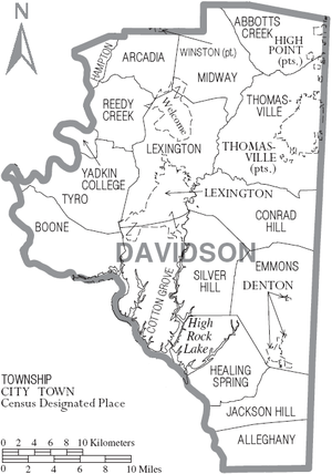
Lexington is the county seat of Davidson County, North Carolina, United States. As of the 2020 census, the town had a population of 19,632. It is located in central North Carolina, 20 miles (32 km) south of Winston-Salem. Major highways include I-85, I-85B, U.S. Route 29, U.S. Route 70, U.S. Route 52 / I-285 and U.S. Route 64. Lexington is part of the Piedmont Triad region of the state.

<span class="mw-page-title-main">Albemarle, North Carolina</span> City in North Carolina, United States

Albemarle is a city in and the county seat of Stanly County, North Carolina, United States. The population was 16,432 in the 2020 census.

<span class="mw-page-title-main">Piedmont Triad</span> Region in North Carolina

The Piedmont Triad is a metropolitan region in the north-central part of the U.S. state of North Carolina anchored by three cities: Greensboro, Winston-Salem, and High Point. This close group of cities lies in the Piedmont geographical region of the United States and forms the basis of the Greensboro–Winston-Salem–High Point, NC Combined Statistical Area. As of 2012, the Piedmont Triad has an estimated population of 1,611,243 making it the 33rd largest combined statistical area in the United States.

<span class="mw-page-title-main">Yadkin River</span> River in North Carolina, United States

The Yadkin River is one of the longest rivers in the US state of North Carolina, flowing 215 miles (346 km). It rises in the northwestern portion of the state near the Blue Ridge Parkway's Thunder Hill Overlook. Several parts of the river are impounded by dams for water, power, and flood control. The river becomes the Pee Dee River at the confluence of the Uwharrie River south of the community of Badin and east of the town of Albemarle. The river then flows into South Carolina near Cheraw, which is at the Fall Line. The entirety of the Yadkin River and the Great Pee Dee River is part of the Yadkin-Pee Dee River Basin.

<span class="mw-page-title-main">Yadkin Valley AVA</span>

The Yadkin Valley AVA is an American Viticultural Area that includes land in seven counties of northwestern North Carolina. The AVA encompasses an area of approximately 1,400,000 acres (5,666 km2) in the Yadkin River valley. The Yadkin Valley AVA includes all of Wilkes, Surry, and Yadkin counties, and parts of Davie, Davidson, Forsyth, and Stokes counties. Yadkin Valley is home to 44 wineries.

Tyro is an unincorporated community and census-designated place (CDP) located 7 miles (11 km) west of Lexington and 24 miles (39 km) south of Winston-Salem in Davidson County, North Carolina, United States. As of the 2020 census, the community had a population of 8,926.

<span class="mw-page-title-main">Badin Lake</span> Reservoir in Uwharrie Lakes Region, North Carolina

Badin Lake is one of a series of lakes created by the damming of the Yadkin-Pee Dee River in the Uwharrie Lakes Region of the United States. The Badin Lake Dam was built in 1917 to support local aluminum smelting plant, Alcoa, and the associated community of Badin was named for the founder, Adrien Badin. The power generation unit was sold to Cube Hydro Carolinas in February 2017. Badin Lake is in the Piedmont area of North Carolina. It is contained by Narrows Dam at the town of Badin, North Carolina. Sitting within a valley, the lake is very deep, with a maximum depth of 190 ft. The lake occupies 5,350 acres (22 km2) and has 115 mi (185 km) of shoreline. Its waters have an average summer temperature of 84.4 °F (29.1 °C) and an average winter temperature of 50.6 °F (10.3 °C). No ferries cross Badin Lake. The northernmost point of Morrow Mountain State Park is roughly 2 miles (3.2 km) downstream from Narrows Dam. The lake lies within Stanly, Davidson, Montgomery, and Rowan counties. Much of the lake's eastern shoreline lies within the Uwharrie National Forest.

<span class="mw-page-title-main">High Rock Lake</span> Lake in North Carolina, United States

High Rock Lake is a reservoir located on the Yadkin River in central North Carolina in the counties of Davidson and Rowan. Built in 1926-27 by the Tallassee Power Company, a wholly owned subsidiary of the Aluminum Company of America (Alcoa), the lake is the northernmost of a series of four hydroelectric projects designed at the time to support the company’s Badin Works, a large aluminum smelting operation located 16 miles downstream in the community of Badin. After the permanent closing of the Badin Works in 2007, Alcoa continued to operate its Yadkin hydroelectric facilities until selling them to Cube Hydro Carolinas in 2016. 

References

  1. 1 2 3 "QuickFacts: Davidson County, North Carolina". United States Census Bureau. Retrieved March 21, 2024.
  2. "Find a County". National Association of Counties. Archived from the original on May 31, 2011. Retrieved June 7, 2011.
  3. "Davidson County Genealogy". North Carolina Genealogy. Archived from the original on April 30, 2011. Retrieved April 14, 2011.
  4. Gannett, Henry (1905). The Origin of Certain Place Names in the United States. Govt. Print. Off. pp.  101.
  5. Jack Scism, "Remember When?", Greensboro News & Record, January 23, 2011.
  6. Jack Scism, "Remember When?", Greensboro News & Record, February 6, 2011.
  7. "2020 County Gazetteer Files – North Carolina". United States Census Bureau. August 23, 2022. Retrieved September 9, 2023.
  8. Hunter, Earl. "Uwharrie National Forest - North Carolina". Black Folks Camp Too. Retrieved November 6, 2022.
  9. 1 2 "Lake Thom-A-Lex Park". Davidson County, NC. Retrieved July 24, 2022.
  10. 1 2 "NCWRC Game Lands". www.ncpaws.org. Retrieved March 30, 2023.
  11. "South Potts Creek (in Davidson County, NC)". northcarolina.hometownlocator.com. Retrieved April 14, 2023.
  12. "U.S. Decennial Census". United States Census Bureau. Retrieved January 14, 2015.
  13. "Historical Census Browser". University of Virginia Library. Archived from the original on August 11, 2012. Retrieved January 14, 2015.
  14. Forstall, Richard L., ed. (March 27, 1995). "Population of Counties by Decennial Census: 1900 to 1990". United States Census Bureau. Retrieved January 14, 2015.
  15. "Census 2000 PHC-T-4. Ranking Tables for Counties: 1990 and 2000" (PDF). United States Census Bureau. April 2, 2001. Archived (PDF) from the original on March 27, 2010. Retrieved January 14, 2015.
  16. "State & County QuickFacts". United States Census Bureau. Archived from the original on June 6, 2011. Retrieved October 19, 2013.
  17. "Explore Census Data". data.census.gov. Retrieved December 20, 2021.
  18. "U.S. Census website". United States Census Bureau . Retrieved January 31, 2008.
  19. Leip, David. "Dave Leip's Atlas of U.S. Presidential Elections". uselectionatlas.org. Retrieved March 15, 2018.
  20. "Géographie électorale". geoelections.free.fr. Archived from the original on November 18, 2005. Retrieved January 13, 2021.
  21. "County Commissioners". www.co.davidson.nc.us. Retrieved February 13, 2024.
  22. "Everybody's Day | Thomasville, North Carolina Chamber of Commerce". www.everybodysday.com. Archived from the original on July 25, 2006. Retrieved March 15, 2018.
  23. "Farmpark".
  24. Camping in Piedmont, North Carolina Archived February 14, 2005, at the Wayback Machine
  25. "Max Lanier History and Photos".