Craven County, North Carolina

Last updated

Craven County
Craven County Courthouse, New Bern.jpg
Craven County Courthouse in New Bern
Craven County Flag.gif
Craven County Seal.jpg
Map of North Carolina highlighting Craven County.svg
Location within the U.S. state of North Carolina
North Carolina in United States.svg
North Carolina's location within the U.S.
Coordinates: 35°07′N77°05′W / 35.12°N 77.08°W / 35.12; -77.08
CountryFlag of the United States.svg United States
StateFlag of North Carolina.svg  North Carolina
Founded1712
Named for William, Earl of Craven
Seat New Bern
Largest communityNew Bern
Area
  Total773.28 sq mi (2,002.8 km2)
  Land706.57 sq mi (1,830.0 km2)
  Water66.71 sq mi (172.8 km2)  8.63%
Population
 (2020)
  Total100,720
  Estimate 
(2023)
102,391
  Density142.55/sq mi (55.04/km2)
Time zone UTC−5 (Eastern)
  Summer (DST) UTC−4 (EDT)
Congressional district 3rd
Website www.cravencounty.com

Craven County is located in the U.S. state of North Carolina. As of the 2020 census, the population was 100,720. [1] Its county seat is New Bern. [2] The county was created in 1705 as Archdale Precinct from the now-extinct Bath County. It was renamed Craven Precinct in 1712 and gained county status in 1739. [3] [4] It is named for William, Earl of Craven, who lived from 1606 to 1697. Craven County is part of the New Bern, NC Micropolitan Statistical Area. [5]

Contents

History

Early history

On August 4, 1661, George Durant purchased land from Cisketando, king of the Yeopim Indian tribe. On March 13, 1662, a second purchase was made from Kilcocanen, another Yeopim. By 1662 Durant was living in Virginia on a tract of land along the Perquimans River which flows into Albemarle Sound, which became part of the Carolina colony in 1665. [6]

Creation

The land eventually constituting Craven was first organized as a portion of Bath County. On December 3, 1705, a portion of Bath was split off to form the new Archdale County. In about 1712 it was renamed Craven County. According to historian William S. Powell, it was most likely named in honor of William, Lord Craven a lord proprietor of the Carolina colony who died the previous year. Others state that the county was named for William's great uncle, William, Earl of Craven, who was one of the original eight lords proprietor of the colony, or the Lord Craven's son, also William, Lord Craven, who was actively serving as a lord proprietor at the time the county's name was changed. [7] In 1722 a portion of Craven was split off to form Carteret County. [8] New Hanover County and Johnston County were formed from Craven in 1729 and 1746, respectively. [9] Craven's borders were altered and redrawn several times between 1757 and 1852. [10]

During the initial years of colonization, the population of Craven County was sparse and grew slowly. By 1740, however, the town of New Bern began growing rapidly and became the seat for the Governorship. [11] John Carter served as the first sheriff of Craven County, but died in 1740 in the line of duty, when ambushed by an outlaw he was trying to apprehend. In 1746 an act was passed establishing New Bern as the capital of the province and, although the act was later repealed, the General Court met at New Bern in Craven County after 1747. [12] [13]

In 1749 James Davis, the colony's first printer, arrived at New Bern and became the official printer for the North Carolina Assembly. [14] In 1751, Davis established and began printing the North Carolina Gazette , North Carolina's first newspaper. [15] In 1754, he was elected Sheriff of Craven County. [16]

Antebellum period

Craven developed an economy centered around agriculture, timber and turpentine, small manufacturing, and commerce emanating from the port of New Bern. [17] Various fruits and vegetables were among the most popular crops, with cotton production declining in popularity after adverse weather conditions in 1821. Some cattle was also kept in the county. [18] Commercial fishing became more common in the late 1840s, while shipbuilding declined later in the Antebellum period. [19] Slaves served as a key labor force in the local economy, though unlike other eastern counties in the state, which had overwhelmingly rural slave populations, almost 40 percent of Craven's slaves were kept in New Bern. [20]

The Panic of 1819 heavily impacted the county and triggered a two decade-long period of economic contraction. [21] Railroad service was introduced in the 1850s. [22] The population rose from 13,394 in 1820 to 16,268 by 1860, though poverty remained a problem and many born in the country migrated elsewhere in search of better economic prospects. [23] Despite the difficulties, Craven remained a center of political and social activity in the state and New Bern remained one of the largest cities in North Carolina throughout the antebellum period. [24]

Civil War

Following North Carolina's secession from the United States and entrance into the American Civil War on the side of the Confederate States of America in 1861, New Bern became a center for Confederate political and military activity. [25] By March 1862, the white men of the county had formed nine permanent companies of troops and three temporary ones. Some of these forces served throughout the entire war's duration. [26] The Battle of Hatteras Inlet Batteries in August 1861 gave United States forces a foothold in eastern North Carolina and provoked the flight of women and children from New Bern. [27]

Reconstruction

The county's economy was heavily impacted by the Civil War with the depletion of livestock, damage of property, and the emancipation of slaves. [28] Most food crop production also suffered, though cotton, tobacco, and rice yields increased. Lumber and naval stores industries persisted, though somewhat weakened. The conclusion of the conflict led to regained confidence in economic activity. The shipping industry in New Bern grew and several new businesses, including a bank, were established. [29] Some black freedmen were assigned work by federal troops or enrolled into Freedmen's Bureau schools. [30] Most of the rest found unskilled work in the local farming, fishing, and turpentine industries. Those that entered skilled labor professions were faced with a rivalry from white contemporaries. [31]

The advent of Congressional Reconstruction in 1867 and 1868 led to profound political changes in Craven County. [32] General Edward Canby, the commander of the Second Military District, replaced New Bern's municipal government and also chose the county's sheriff. Following registration efforts, black voters outnumbered whites in the county, and remained a majority of the electorate until the end of the century. [33] Together with local whites who had held Unionist sympathies before the war and recently arrived carpetbaggers, they constituted a strong base for the Republican Party. [34] In the returns for the 1868 elections, Republicans' margin of victory was the second largest among the counties in the state. [35] A portion of Craven was annexed to the new Pamlico County in 1872. [36]

Geography

Craven County, North Carolina
Interactive map of Craven County

According to the U.S. Census Bureau, the county has a total area of 773.28 square miles (2,002.8 km2), of which 706.57 square miles (1,830.0 km2) is land and 66.71 square miles (172.8 km2) (8.63%) is water. [37] It is bordered by Pitt County and Beaufort County to the north, Pamlico County to the east, Carteret County to the south, Jones County to the west, and Lenoir County to the northwest. [38] Craven County lies within the Neuse River Basin. [4]

National protected areas

State and local protected areas/sites

Major water bodies

Major highways

Major infrastructure

Demographics

Historical population
CensusPop.Note
1790 10,474
1800 10,245−2.2%
1810 12,67623.7%
1820 13,3945.7%
1830 13,7342.5%
1840 13,438−2.2%
1850 14,7099.5%
1860 16,26810.6%
1870 20,51626.1%
1880 19,729−3.8%
1890 20,5334.1%
1900 24,16017.7%
1910 25,5945.9%
1920 29,04813.5%
1930 30,6655.6%
1940 31,2982.1%
1950 48,82356.0%
1960 58,77320.4%
1970 62,5546.4%
1980 71,04313.6%
1990 81,61314.9%
2000 91,43612.0%
2010 103,50513.2%
2020 100,720−2.7%
2023 (est.)102,391 [1] 1.7%
U.S. Decennial Census [40]
1790–1960 [41] 1900–1990 [42]
1990–2000 [43] 2010 [44] 2020 [1]

2020 census

Craven County racial composition [45]
RaceNumberPercentage
White (non-Hispanic)64,93364.47%
Black or African American (non-Hispanic)19,90319.76%
Native American 3180.32%
Asian 3,0593.04%
Pacific Islander 1500.15%
Other/Mixed 5,1625.13%
Hispanic or Latino 7,1957.14%

As of the 2020 census, there were 100,720 people, 42,221 households, and 28,502 families residing in the county.

2000 census

At the 2000 census, [46] there were 91,436 people, 34,582 households, and 25,071 families residing in the county. The population density was 129 people per square mile (50 people/km2). There were 38,150 housing units at an average density of 54 units per square mile (21 units/km2). The racial makeup of the county was 69.94% White, 25.12% Black or African American, 0.42% Native American, 0.99% Asian, 0.06% Pacific Islander, 1.78% from other races, and 1.68% from two or more races. 4.02% of the population were Hispanic or Latino of any race.

There were 34,582 households, out of which 33.30% had children under the age of 18 living with them, 56.80% were married couples living together, 12.50% had a female householder with no husband present, and 27.50% were non-families. 23.40% of all households were made up of individuals, and 8.90% had someone living alone who was 65 years of age or older. The average household size was 2.50 and the average family size was 2.93.

In the county, the population was spread out, with 24.60% under the age of 18, 12.80% from 18 to 24, 27.90% from 25 to 44, 21.20% from 45 to 64, and 13.40% who were 65 years of age or older. The median age was 34 years. For every 100 females there were 101.90 males. For every 100 females age 18 and over, there were 101.50 males.

The median income for a household in the county was $35,966, and the median income for a family was $42,574. Males had a median income of $28,163 versus $21,412 for females. The per capita income for the county was $18,423. About 9.90% of families and 13.10% of the population were below the poverty line, including 18.50% of those under age 18 and 11.00% of those age 65 or over.

Government and politics

Government

Craven County Administration Building in New Bern Craven County Administration Building 01.jpg
Craven County Administration Building in New Bern

Craven County is led by a seven-member board of commissioners, each of whom are elected to represent a district. [47]

Craven County is a member of the Eastern Carolina Council of Governments, a regional multi-county planning and economic coordination body. [48] It is located in the North Carolina Senate's 2nd district and the North Carolina House of Representatives' 3rd district, and 13th district. [49]

Craven County lies within the bounds of the 4th Prosecutorial District, the 3B Superior Court District, and the 3B District Court District. [50]

Politics

Craven is a typical “Solid South” county in its presidential voting patterns. It was solidly Democratic until the 1960s: in five elections from 1932 to 1948 the Republican Party did not reach fifteen percent of the vote, and only in 1928 when a large anti-Catholic vote was cast against Al Smith did the GOP reach twenty percent between at least 1900 and 1948. The national Democratic party's support for the Civil Rights Movement caused its white electorate to defect to George Wallace’s American Independent campaign in 1968. Since that time, Craven has become a strongly Republican county. The last Democrat to carry Craven County was Jimmy Carter in 1976. [53] As of March 2022, there were 70,286 registered voters in the county. Of those, 26,225 were registered Republican, 20,135 were registered Democrats, and 23,393 registered unaffiliated. [54]

Communities

Map of Craven County with municipal and township labels Map of Craven County North Carolina With Municipal and Township Labels.PNG
Map of Craven County with municipal and township labels

Cities

Towns

Census-designated places

Other unincorporated communities

Townships

By the requirements of the North Carolina Constitution of 1868, the county was divided into 8 townships which do not have names:

See also

Related Research Articles

<span class="mw-page-title-main">Montgomery County, North Carolina</span> County in North Carolina, United States

Montgomery County is a rural county located in the southern Piedmont of the U.S. state of North Carolina. As of the 2020 census, the population was 25,751. Its county seat is Troy.

<span class="mw-page-title-main">Warren County, North Carolina</span> County in North Carolina, United States

Warren County is a county located in the northeastern Piedmont region of the U.S. state of North Carolina, on the northern border with Virginia, made famous for a landfill and birthplace of the environmental justice movement. As of the 2020 census, its population was 18,642. Its county seat is Warrenton. It was a center of tobacco and cotton plantations, education, and later textile mills.

<span class="mw-page-title-main">Randolph County, North Carolina</span> County in North Carolina, United States

Randolph County is a county located in the U.S. state of North Carolina. As of the 2020 census, the population was 144,171. Its county seat is Asheboro.

<span class="mw-page-title-main">Pamlico County, North Carolina</span> County in North Carolina, United States

PamlicoCounty is a county located in the U.S. state of North Carolina. As of the 2020 census, the population was 12,276. Its county seat is Bayboro.

<span class="mw-page-title-main">Jones County, North Carolina</span> County in North Carolina, United States

Jones County is a county located in the U.S. state of North Carolina. As of the 2020 census, the population was 9,172, making it the fourth-least populous county in North Carolina. Its county seat is Trenton. Jones County is part of the New Bern, NC Micropolitan Statistical Area.

<span class="mw-page-title-main">Hyde County, North Carolina</span> County in North Carolina, United States

Hyde County is a county located in the U.S. state of North Carolina. As of the 2020 census, the population was 4,589, making it the second-least populous county in North Carolina. Its county seat is Swan Quarter. The county was created in 1705 as Wickham Precinct. It was renamed Hyde Precinct in 1712 and gained county status in 1739.

<span class="mw-page-title-main">Edgecombe County, North Carolina</span> County in North Carolina, United States

Edgecombe County is a county located in the U.S. state of North Carolina. As of the 2020 census, the population was 48,900. Its county seat is Tarboro.

<span class="mw-page-title-main">Carteret County, North Carolina</span> County in North Carolina, United States

Carteret County is a county located in the U.S. state of North Carolina. As of the 2020 census, the population was 67,686. Its county seat is Beaufort. The county was created in 1722 as Carteret Precinct and gained county status in 1739. It was named for Sir George Carteret, one of the 17th century English Lords Proprietor, or for his descendant and heir John Carteret, 2nd Earl Granville.

<span class="mw-page-title-main">Beaufort County, North Carolina</span> County in North Carolina, United States

Beaufort County is a county located in the U.S. state of North Carolina. As of the 2020 census, the population was 44,652. Its county seat is Washington. The county was founded in 1705 as Pamptecough Precinct. Originally included in Bath County, it was renamed Beaufort Precinct in 1712 and became Beaufort County in 1739.

<span class="mw-page-title-main">Alleghany County, North Carolina</span> County in North Carolina, United States

Alleghany County is a county located in the U.S. state of North Carolina. As of the 2020 census, the population was 10,888. Its county seat is Sparta.

<span class="mw-page-title-main">Havelock, North Carolina</span> City in North Carolina, United States

Havelock is a city in Craven County, North Carolina, United States. The population was 20,735 at the 2010 census. The city is home to Marine Corps Air Station Cherry Point, the world's largest Marine Corps air station, and home to the 2nd Marine Aircraft Wing.

<span class="mw-page-title-main">New Bern, North Carolina</span> City in North Carolina, United States

New Bern is a city in and the county seat of Craven County, North Carolina, United States. At the 2020 census, it had a population of 31,291.

<span class="mw-page-title-main">Arapahoe, North Carolina</span> Town in North Carolina, United States

Arapahoe is a town in Pamlico County, North Carolina, United States. As of the 2010 census, the town population was 556. Arapahoe shares many of its roles and duties with Minnesott Beach, North Carolina. It is part of the New Bern, North Carolina Micropolitan Statistical Area.

<span class="mw-page-title-main">Neuse River</span> River rising in the Piedmont of North Carolina

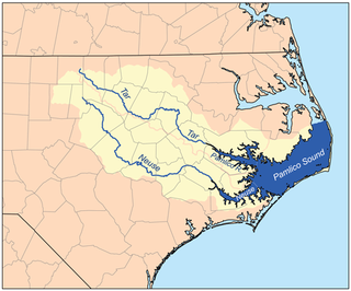
The Neuse River is a river rising in the Piedmont of North Carolina and emptying into Pamlico Sound below New Bern. Its total length is approximately 275 miles (443 km), making it the longest river entirely contained in North Carolina. The Trent River joins the Neuse at New Bern. Its drainage basin, measuring 5,630 square miles (14,600 km2) in area, also lies entirely inside North Carolina. It is formed by the confluence of the Flat and Eno rivers prior to entering the Falls Lake reservoir in northern Wake County. Its fall line shoals, known as the Falls of the Neuse, lie submerged under the waters of Falls Lake. This River also creates the beauty of the Neuse River Trail, a 34.5 miles (55.5 km) long greenway that stretches from Falls Lake Dam, Raleigh, North Carolina to Legend Park, Clayton, North Carolina.

<span class="mw-page-title-main">Craven Community College</span> College in New Bern, North Carolina, U.S.

Craven Community College is a public community college with its main campus in New Bern, North Carolina. It also has campuses in Havelock and Marine Corps Air Station Cherry Point. Established in 1965, it was originally an extension of Lenoir Community College—Craven IEC. It later added degree-awarding programs in several technical fields and became a technical institute. In the early 1970s, college-transfer degrees were added and the school became a community college. It is part of the North Carolina Community College System.

<span class="mw-page-title-main">North Carolina's 3rd congressional district</span> U.S. House district for North Carolina

North Carolina's 3rd congressional district is located on the Atlantic coast of North Carolina. It covers the Outer Banks and the counties adjacent to the Pamlico Sound.

<span class="mw-page-title-main">New Bern Metropolitan Statistical Area</span>

The New Bern Metropolitan Statistical Area, as defined by the United States Census Bureau, is an area consisting of three counties in the Inner Banks region of eastern North Carolina, anchored by the city of New Bern. The designation of the area was changed from Micropolitan to Metropolitan in 2013.

<span class="mw-page-title-main">North Carolina Highway 306</span> State highway in North Carolina, US

North Carolina Highway 306 (NC 306) is a primary state highway in the U.S. state of North Carolina. The highway provides a link between Havelock, Minnesott Beach, and Grantsboro. The route is primarily rural, and uses two free ferries to cross the Neuse and Pamlico Rivers before reaching NC 92/NC 99 near Gaylord.

Cherry Branch is a planned community and census-designated place (CDP) in Craven County, North Carolina, United States. It was first listed as a CDP in the 2020 census with a population of 1,211.

<span class="mw-page-title-main">James Davis (printer)</span> First public printer to the Colony of North Carolina (1721–1785)

James Davis was an early American printer and the first printer and first postmaster of the colony of North Carolina. He was also the founder and printer of the North-Carolina Gazette, North Carolina colony's first newspaper. After working with William Parks in Virginia he removed to New Bern to pursue a printing career upon learning that an official printer was needed in that colony. Soon after his arrival he began to put down roots, married, and became active in local politics, holding several positions in public office, including membership in the North Carolina Assembly and thereafter a county Sheriff.

References

  1. 1 2 3 "QuickFacts: Craven County, North Carolina". United States Census Bureau. Retrieved March 21, 2024.
  2. "Find a County". National Association of Counties. Archived from the original on May 31, 2011. Retrieved June 7, 2011.
  3. "North Carolina: Individual County Chronologies". North Carolina Atlas of Historical County Boundaries. The Newberry Library. 2009. Archived from the original on March 4, 2016. Retrieved January 22, 2015.
  4. 1 2 Powell, William S. (2006). "Craven County". NCPedia. North Carolina Government & Heritage Library. Retrieved April 23, 2023.
  5. "OMB Bulletin No. 23-01: Revised Delineations of Metropolitan Statistical Areas, Micropolitan Statistical Areas, and Combined Statistical Areas, and Guidance on Uses of the Delineations of These Areas" (PDF). United States Office of Management and Budget . July 21, 2023. Retrieved August 10, 2023.
  6. Connor, 1919, Vol. I, pp. 26-27
  7. Powell 1976, p. 12.
  8. Corbitt 2000, p. 74.
  9. Corbitt 2000, p. 75.
  10. Corbitt 2000, pp. 75–78.
  11. dill, 1946, p. 47
  12. The historical records of North Carolina, Vol. I, p. 58
  13. The historical records of North Carolina, Vol. II, p. 2
  14. Wroth, 1938, p. 48
  15. Thomas, 1874, Vol. I, p. 338; Vol. II, p. 166
  16. Powell, 2000, pp. 34-35
  17. Watson 1987, pp. 247, 249.
  18. Watson 1987, p. 249.
  19. Watson 1987, pp. 255–256.
  20. Watson 1987, p. 250.
  21. Watson 1987, p. 267.
  22. Watson 1987, pp. 289, 291.
  23. Watson 1987, p. 294.
  24. Watson 1987, pp. 294–295.
  25. Watson 1987, pp. 369–370.
  26. Watson 1987, p. 371.
  27. Watson 1987, p. 372.
  28. Watson 1987, p. 442.
  29. Watson 1987, p. 443.
  30. Watson 1987, p. 447.
  31. Watson 1987, pp. 447–448.
  32. Watson 1987, pp. 431–433.
  33. Watson 1987, p. 432.
  34. Watson 1987, pp. 431–432.
  35. Watson 1987, p. 436.
  36. Corbitt 2000, p. 78.
  37. "2020 County Gazetteer Files – North Carolina". United States Census Bureau. August 23, 2022. Retrieved September 9, 2023.
  38. Powell 1976, p. 126.
  39. 1 2 3 "NCWRC Game Lands". www.ncpaws.org. Retrieved March 30, 2023.
  40. "U.S. Decennial Census". United States Census Bureau. Retrieved January 13, 2015.
  41. "Historical Census Browser". University of Virginia Library. Archived from the original on August 11, 2012. Retrieved January 13, 2015.
  42. Forstall, Richard L., ed. (March 27, 1995). "Population of Counties by Decennial Census: 1900 to 1990". United States Census Bureau. Retrieved January 13, 2015.
  43. "Census 2000 PHC-T-4. Ranking Tables for Counties: 1990 and 2000" (PDF). United States Census Bureau. April 2, 2001. Archived (PDF) from the original on March 27, 2010. Retrieved January 13, 2015.
  44. "State & County QuickFacts". United States Census Bureau. Archived from the original on July 28, 2011. Retrieved October 18, 2013.
  45. "Explore Census Data". data.census.gov. Retrieved December 24, 2021.
  46. "U.S. Census website". United States Census Bureau . Retrieved January 31, 2008.
  47. "Board of Commissioners". Craven County, North Carolina. Craven County Government. Retrieved January 18, 2023.
  48. Clouser, Elise (August 2, 2021). "Eastern Carolina Council board dismisses executive director". Carteret County News-Times. Retrieved January 19, 2023.
  49. "Craven County Representation : 2023-2024 Session". North Carolina General Assembly. Retrieved January 19, 2023.
  50. "Craven County". North Carolina Judicial Branch. Retrieved January 12, 2023.
  51. Leip, David. "Dave Leip's Atlas of U.S. Presidential Elections". uselectionatlas.org. Retrieved March 15, 2018.
  52. "Our Campaigns - U.S. President" . Retrieved January 22, 2021.
  53. "1976 Presidential General Election Results - North Carolina". uselectionatlas.org. 2019. Retrieved April 1, 2023.
  54. Dunnell, Trevor (April 25, 2022). "Could early voting play a role in who becomes Craven County's next elected officials?". Sun Journal. Retrieved January 17, 2023.

Works cited

Further reading