Hyde County, North Carolina

Last updated

Hyde County
Hyde County Courthouse, Swan Quarter (current).jpg
Hyde County Courthouse in Swan Quarter
Hyde county nc.JPG
Map of North Carolina highlighting Hyde County.svg
Location within the U.S. state of North Carolina
North Carolina in United States.svg
North Carolina's location within the U.S.
Coordinates: 35°25′N76°09′W / 35.41°N 76.15°W / 35.41; -76.15
CountryFlag of the United States.svg United States
StateFlag of North Carolina.svg  North Carolina
Founded1712
Named for Edward Hyde
Seat Swan Quarter
Largest community Ocracoke
Area
  Total1,459.05 sq mi (3,778.9 km2)
  Land612.35 sq mi (1,586.0 km2)
  Water846.70 sq mi (2,192.9 km2)  58.03%
Population
 (2020)
  Total4,589
  Estimate 
(2023)
4,607
  Density7.49/sq mi (2.89/km2)
Time zone UTC−5 (Eastern)
  Summer (DST) UTC−4 (EDT)
Congressional district 3rd
Website www.hydecountync.gov

Hyde County is a county located in the U.S. state of North Carolina. As of the 2020 census, the population was 4,589, [1] making it the second-least populous county in North Carolina. Its county seat is Swan Quarter. [2] The county was created in 1705 as Wickham Precinct. It was renamed Hyde Precinct in 1712 and gained county status in 1739. [3] [4]

Contents

History

Early history and creation

Sources conflict over when the area that eventually grew to encompass Hyde County was settled by Europeans. The earliest known colonial land deeds in the present day county date from 1704 or 1705. European settlement remained sparse over the subsequent decades, though the English established a small for on the northern shore of Lake Mattamuskeet. In 1711, Algonquin-speaking Native Americans in the area joined with the proximate Tuscarora people in launching a war against the settlers. The conflict was won by the settlers in 1715, with many captured Native Americans enslaved and the remaining Tuscaroras largely expelled from North Carolina. The local Algonquin natives were gathered on the newly-created Mattamuskeet Reservation, which comprised most of the eastern mainland section of what eventually became Hyde County. Due to pressure from the settlers, the Native Americans began selling their land in 1731. [5] By 1792, all of the reservation had been sold, and its inhabitants either left the region or intermarried with local European Americans and African Americans. [6]

The county was formed December 3, 1705, as Wickham Precinct, one of three precincts within Bath County. The name Wickham was derived from the manor of Temple Wycombe in Buckinghamshire, England, the family home of John Archdale, governor of North and South Carolina from 1695 to 1696. In 1712, it was renamed Hyde Precinct for Edward Hyde, [7] Governor of North Carolina from 1711 to 1712. In 1739, Bath County was abolished, and Hyde Precinct became Hyde County. In 1745, Lake Mattamuskeet and its adjoining territory were transferred from Currituck County to Hyde County.

Antebellum

Communities coalesced and churches were formed in the aftermath of the Revolutionary War. [8]

In 1819, the portion of Hyde County west of the Pungo River was annexed by Beaufort County. [9] Four years later, the area of Currituck County south of New Inlet was transferred to Hyde County. This area included Hatteras Island. [4] [10]

In 1834, an "apprenticeship" program was begun whereby local Native American children were placed under the tutelage of white families to learn trades. Lasting until 1865, the policy resulted in the loss of much independent Native American cultural identity in the area. [11] In 1845, Ocracoke Island was transferred from Carteret County to Hyde County. [12] Ocracoke benefitted from a modest shipping industry which persisted into the mid-1800s, while the mainland portion of county was largely agrarian, though farmers struggled in the swampy terrain. [13] Locals also fished and harvested oysters. [14] In 1860, 37.4% of Hyde's population were slaves—a proportion lower than many other counties in eastern North Carolina. [13]

Later history

Local residents were divided by the outbreak of the American Civil War, though a number enlisted into the Confederate States Army. Several skirmishes took place in the county between federal and Confederate forces during 1863 and 1864, and a substantial number of slaves fled to federally-held territory to seek their emancipation. [15]

During the Reconstruction era after the war, some residents, white and newly-freed blacks, migrated out of Hyde. [16] In 1870, Hyde County was reduced to its present dimensions, when its northeastern part was combined with parts of Currituck County and Tyrrell County to form Dare County. [17] Northern investors also took an interest in the county during Reconstruction, particularly in the harvest of timber. [16] Between 1870 and 1920, the county experienced some economic prosperity due to the logging of cypress, juniper, and oak trees. [18] Several sawmills and railroads were established. The industry declined as the county's forests thinned, before being overcome by the Great Depression. [19] Hyde County received its first paved road in the 1920s and gained electric service in 1935. [20]

By the mid-20th century, the agriculturally-reliant county was in economic and demographic decline, benefiting none from the public infrastructure investments and industrial growth of the postwar economic boom occurring elsewhere in the state. Several towns that had prospered in the early 1900s were left totally abandoned, [21] and the vast majority of county residents were impoverished. [22] The timber industry continued to provide some employment, while after World War II the seafood packing industry grew. [23] Jim Crow racial segregation took hold after the close of the 19th century and persisted, depriving blacks of political and economic opportunities available to whites. [24] In 1950, about one third of white residents had access to hot running water and flushing toilets, while no blacks had such amenities, and tended to live near small creeks and drainage canals. [11] Racial separation was less pronounced on Ocracoke Island, where blacks and whites lived in closer physical proximity to one another. [25]

Geography and physical features

Hyde County, North Carolina
Interactive map of Hyde County

According to the U.S. Census Bureau, the county has a total area of 1,459.05 square miles (3,778.9 km2), of which 612.35 square miles (1,586.0 km2) is land and 846.70 square miles (2,192.9 km2) (58.03%) is water. [26] It is the second-largest county in North Carolina by total area. [26] Hyde County's comprises an inland portion and Ocracoke Island, a part of the Outer Banks. [27] It is bordered by Dare and Tyrrell counties to the north, by Washington County to the northwest, by Beaufort County to the west, and by Pamlico and Carteret counties to the southwest. [28] The mainland portion of the county also borders the Pamlico Sound, while Ocracoke Island rests on the Atlantic Ocean. [29]

Hyde County is characterized by many swamps. [27] It has a flat topography and its highest point, a spot west of Alligator Lake, rests about 18 feet above sea level. [30] Owing to its low elevation, the county suffers from frequent flooding and saltwater intrusion of its soil. [31] Lake Mattamuskeet is the largest naturally-occurring lake in North Carolina. [13]

Hyde County is within the path of the Atlantic Flyway, and thus features seasonal populations of various migratory waterfowl species, including tundra swan and Canada geese. [27]

National protected areas

State and local protected areas

Major water bodies

Major highways

Major infrastructure

Demographics

Historical population
CensusPop.Note
1790 4,204
1800 4,82914.9%
1810 6,02924.8%
1820 4,967−17.6%
1830 6,18424.5%
1840 6,4584.4%
1850 7,63618.2%
1860 7,7321.3%
1870 6,445−16.6%
1880 7,76520.5%
1890 8,90314.7%
1900 9,2784.2%
1910 8,840−4.7%
1920 8,386−5.1%
1930 8,5502.0%
1940 7,860−8.1%
1950 6,479−17.6%
1960 5,765−11.0%
1970 5,571−3.4%
1980 5,8735.4%
1990 5,411−7.9%
2000 5,8267.7%
2010 5,810−0.3%
2020 4,589−21.0%
2023 (est.)4,607 [1] 0.4%
U.S. Decennial Census [33]
1790–1960 [34] 1900–1990 [35]
1990–2000 [36] 2010 [37] 2020 [1]

2020 census

Hyde County racial composition [38]
RaceNumberPercentage
White (non-Hispanic)2,92863.8%
Black or African American (non-Hispanic)1,15225.1%
Native American 70.15%
Asian 70.15%
Pacific Islander 20.04%
Other/Mixed 1463.18%
Hispanic or Latino 3477.56%

As of the 2020 census, there were 4,589 people in Hyde, making it the second-least populous county in North Carolina. [39]

Demographic change

Hyde County's population peaked with 9,278 people in 1900. [19] Between 1900 and 2000, the county's population declined by almost 50 percent. [13] Between the 2010 and 2020 censuses, Hyde's population dropped by 21 percent, one of the largest population drops by percentage in the state. [39]

Law and government

There are no incorporated communities or municipal governments in Hyde; all local governmental activities occur at the county level. [40] Hyde County is governed by a five-member board of commissioners. Each member is nominated by a township in the county, but all are elected at-large. The commissioners appoint a county manager who oversees county governmental administration. [41]

Hyde County is a member of the Albemarle Commission, a regional economic development organization which serves several counties in eastern North Carolina. [42]

Hyde County is located within North Carolina's 3rd congressional district, [43] the North Carolina Senate's 1st district, and the North Carolina House of Representatives' 79th district. [44]

Politics

The mainland area of Hyde County tends to be dominated by Republicans, while Ocracoke tends to be dominated by Democrats. [46] In the 2020 U.S. presidential election, Republican Donald Trump defeated Democrat Joe Biden 1,408 to 1,035, with only Ocracoke's voting precinct offering a majority for Biden. [47] The county also favored Republican candidates in statewide and most local races. [48]

Economy

Hyde is one of the poorest counties in North Carolina. The economy is sustained by agriculture, fishing, and tourism. [49] Most of the county's businesses are concentrated on Ocracoke Island and cater to tourists. [13]

Education

Hyde County is home to the smallest public school system in North Carolina. The Hyde County Schools comprises two schools.

The only private school in Hyde County is a small Mennonite school located in the northwest section of the county. This school serves the county's Mennonite population.

According to the 2022 American Community Survey, an estimated 16.4 percent of county residents have attained a bachelor's degree or higher level of education. [50]

Healthcare

Hyde County's last hospital closed in 2014. [51] It is one of three counties in North Carolina with no private dental practitioners. [52]

Culture

Hyde County is a popular destination for fishing and bear and duck hunting. Ocracoke attracts many tourists. [46] Most families that reside in Hyde County have generational roots there, and many black and white families share surnames. [53] Historically, natives of both mainland Hyde County and Ocracoke Island often spoke a Hoi Toider dialect of English. [54] The trend has declined over time, and, particularly since the 1970s, newer generations of local African Americans tend to speak a dialect closer to urban variants of African-American Vernacular English. [55]

Media

Hyde County is home to two full power radio stations, WKHC 97.1 FM and WCMS-FM 94.5. These stations are licensed to Hatteras, NC but maintain transmitter facilities outside of Engelhard.

Ocracoke Island is home to WOVV 90.1 FM, a low power non-commercial station.

WHYC 88.5 FM is located on the campus of Mattamuskeet School in Swan Quarter. WHYC is one of only two high school operated stations in North Carolina.

Communities

Map of Hyde County with municipal and township labels Map of Hyde County North Carolina With Municipal and Township Labels.PNG
Map of Hyde County with municipal and township labels

Hyde County has no incorporated municipalities. [40] There are five townships: Currituck, Fairfield, Lake Landing, Ocracoke, and Swan Quarter. [41]

Census-designated places

Unincorporated communities

Townships

A sixth township, Mattamuskeet, is now "unorganized territory" occupied by the federally controlled Mattamuskeet National Wildlife Refuge.

See also

Related Research Articles

<span class="mw-page-title-main">Tyrrell County, North Carolina</span> County in North Carolina, United States

Tyrrell County is a county located in the U.S. state of North Carolina. As of the 2020 census, the population was 3,245, making it the least populous county in North Carolina. Its county seat is Columbia. The county was created in 1729 as Tyrrell Precinct and gained county status in 1739.

<span class="mw-page-title-main">Dare County, North Carolina</span> County in North Carolina, United States

Dare County is the easternmost county in the U.S. state of North Carolina. As of the 2020 census, the population was 36,915. Its county seat is Manteo.

<span class="mw-page-title-main">Currituck County, North Carolina</span> County in North Carolina, United States

Currituck County is the northeasternmost county in the U.S. state of North Carolina. As of the 2020 census, the population was 28,100. Its county seat is Currituck. The county was formed in 1668 as a precinct of Albemarle County and later gained county status in 1739. The name is "traditionally said to be an indigenous word for wild geese; Coratank." Currituck County is included in the Virginia Beach-Chesapeake, VA-NC Combined Statistical Area. It is in the northeastern section of the state and is bounded by the Atlantic Ocean, Currituck Sound, Camden County, Dare County and the Commonwealth of Virginia. Currituck Court House, mentioned as early as 1755, was the name of the county seat. Today the words "Court House" have been dropped and only Currituck is used as the community name.

<span class="mw-page-title-main">Ocracoke, North Carolina</span> Census-designated place in North Carolina, United States

Ocracoke is a census-designated place (CDP) and unincorporated town located at the southern end of Ocracoke Island, located entirely within Hyde County, North Carolina, United States. The population was 948 as of the 2010 census. In the 2020 census, the population had dropped to 797 people.

<span class="mw-page-title-main">Pamlico Sound</span> Largest lagoon along the North American East Coast

Pamlico Sound is a large estuarine lagoon in North Carolina. The largest lagoon along the North American East Coast, it extends 80 mi (130 km) long and 15 to 20 miles wide. It is part of a large, interconnected network of similar lagoons that includes Albemarle Sound, Currituck Sound, Croatan Sound, Roanoke Sound, Pamlico Sound, Bogue Sound, Back Sound, and Core Sound known collectively as the Albemarle-Pamlico sound system. With over 3,000 sq. mi. (7,800 km2) of open water the combined estuary is second only in size to 4,479 sq mi (11,600 km2) Chesapeake Bay in the United States.

<span class="mw-page-title-main">Rodanthe, North Carolina</span> Census-designated place in North Carolina, United States

Rodanthe is an unincorporated community and census-designated place (CDP) located in Dare County, North Carolina, United States, on Hatteras Island, part of North Carolina's Outer Banks. As of the 2020 census it had a population of 213. Rodanthe, along with Waves and Salvo, are part of the settlement of Chicamacomico. Rodanthe includes the original Chicamacomico Life-Saving Station, decommissioned in 1954, but now a museum.

<span class="mw-page-title-main">Hatteras Island</span> Island in North Carolina, US

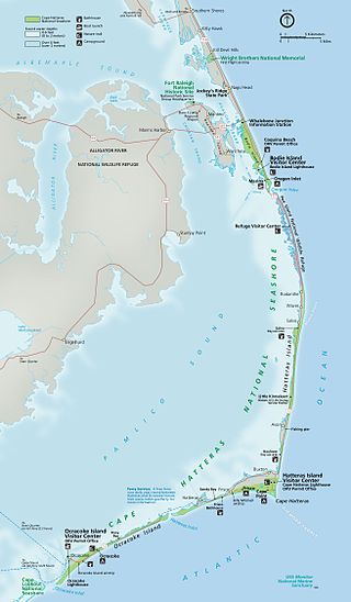
Hatteras Island is a barrier island located off the North Carolina coast. Dividing the Atlantic Ocean and the Pamlico Sound, it runs parallel to the coast, forming a bend at Cape Hatteras. It is part of North Carolina's Outer Banks and includes the communities of Rodanthe, Waves, Salvo, Avon, Buxton, Frisco, and Hatteras. It contains the largest part of the Cape Hatteras National Seashore. Prior to European settlement the island was inhabited by Croatoan Native Americans.

<span class="mw-page-title-main">Hatteras, North Carolina</span> Census-designated place in North Carolina, United States of America

Hatteras is an unincorporated village and census-designated place (CDP) in Dare County, North Carolina, United States, on the Outer Banks island of Hatteras, at its extreme southwestern tip. As of the 2010 census it had a population of 504. Immediately to the west of the village of Hatteras is Hatteras Inlet which separates Hatteras Island from the neighboring Ocracoke Island. North Carolina Highway 12 passes through the community linking it to Frisco to the east and Ocracoke to the west.

<span class="mw-page-title-main">Swan Quarter, North Carolina</span> Census-designated place in North Carolina, United States

Swan Quarter is an unincorporated community and census-designated place (CDP) in Hyde County, North Carolina, United States. It is the county seat of Hyde County. As of the 2010 census, it had a population of 324.

<span class="mw-page-title-main">Outer Banks</span> Barrier islands in North Carolina, United States

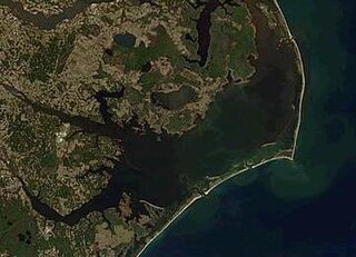
The Outer Banks are a 200 mi (320 km) string of barrier islands and spits off the coast of North Carolina and southeastern Virginia, on the east coast of the United States. They line most of the North Carolina coastline, separating Currituck Sound, Albemarle Sound, and Pamlico Sound from the Atlantic Ocean. A major tourist destination, the Outer Banks are known for their wide expanse of open beachfront and the Cape Hatteras National Seashore. The seashore and surrounding ecosystem are important biodiversity zones, including beach grasses and shrubland that help maintain the form of the land.

High Tider, Hoi Toider, or High Tide English is an American English dialect, or family of dialects, spoken in very limited communities of the South Atlantic United States, particularly several small islands and coastal townships. The exact areas include the rural "Down East" region of North Carolina, which encompasses the Outer Banks and Pamlico Sound—specifically Atlantic, Davis, Sea Level, and Harkers Island in eastern Carteret County, the village of Wanchese, and also Ocracoke—plus the Chesapeake Bay, such as Smith Island in Maryland, as well as Guinea Neck and Tangier Island in Virginia. High Tider has been observed as far west as Bertie County, North Carolina; the term is also a local nickname for any native resident of these regions.

The Machapunga were a small Algonquian language–speaking Native American tribe from coastal northeastern North Carolina. They were part of the Secotan people. They were a group from the Powhatan Confederacy who migrated from present-day Virginia.

Lake Mattamuskeet is the largest natural lake in North Carolina. It is a shallow coastal lake, averaging 2–3 ft feet in depth, and stretches 18 miles (29 km) long and 7 miles (11 km) wide. Lake Mattamuskeet lies on the Albemarle-Pamlico Peninsula.

<span class="mw-page-title-main">North Carolina Highway 12</span> State highway in North Carolina, US

North Carolina Highway 12 (NC 12) is a 148.0-mile-long (238.2 km) primary state highway in the U.S. state of North Carolina, linking the peninsulas and islands of the northern Outer Banks. Most sections of NC 12 are two lanes wide, and there are also two North Carolina Ferry System routes which maintain continuity of the route as it traverses the Outer Banks region. NC 12 is part of the Outer Banks Scenic Byway, a National Scenic Byway. The first NC 12 appeared on the 1924 North Carolina Official Map and at its greatest length ran from NC 30 in Pollocksville to NC 48 near Murfreesboro. Over time it was replaced by both U.S. Route 258 (US 258) and NC 58 and ceased to exist in 1958. The current NC 12 first appeared on the 1964 state highway map running from US 158 in Nags Head to Ocracoke. In 1976 NC 12 was extended to US 70 on the mainland and in 1987 was extended north to Corolla.

The North Carolina Department of Transportation Ferry Division is a branch of NCDOT that is responsible for the operation of over two dozen ferry services that transport passengers and vehicles to several islands along the Outer Banks of North Carolina.

<span class="mw-page-title-main">Hatteras Inlet</span> Estuary in North Carolina, U.S.

Hatteras Inlet is an estuary in North Carolina, located along the Outer Banks, separating Hatteras Island and Ocracoke Island. It connects the Atlantic Ocean to the Pamlico Sound. Hatteras Inlet is located entirely within Hyde County.

<span class="mw-page-title-main">Pocosin Lakes National Wildlife Refuge</span> National Wildlife Refuge in North Carolina, United States

The Pocosin Lakes National Wildlife Refuge is located in North Carolina's Inner Banks on the Albemarle-Pamlico Peninsula in Hyde, Tyrrell, and Washington Counties, North Carolina. Its headquarters is located in Columbia.

<span class="mw-page-title-main">Engelhard, North Carolina</span> Census-designated place in North Carolina, United States

Engelhard is a census-designated place (CDP) and fishing community in Lake Landing Township on the mainland of Hyde County, North Carolina, United States. It has access to Pamlico Sound. As of the 2010 census it had a population of 445.

Hyde County Schools is a public school district in Hyde County, North Carolina. Headquartered in Swan Quarter, currently operates two K-12 schools.

References

  1. 1 2 3 "QuickFacts: Hyde County, North Carolina". United States Census Bureau. Retrieved March 21, 2024.
  2. "Find a County". National Association of Counties. Archived from the original on May 31, 2011. Retrieved June 7, 2011.
  3. "North Carolina: Individual County Chronologies". North Carolina Atlas of Historical County Boundaries. The Newberry Library. 2009. Archived from the original on March 4, 2016. Retrieved January 24, 2015.
  4. 1 2 Vocci, Robert Blair (2006). Powell, William S. (ed.). "Hyde County". NCpedia. University of North Carolina Press. Retrieved September 6, 2023.
  5. Wolfram & Thomas 2008, p. 51.
  6. Wolfram & Thomas 2008, pp. 51–52.
  7. Gannett, Henry (1905). The Origin of Certain Place Names in the United States. Govt. Print. Off. pp.  164.
  8. Wolfram & Thomas 2008, pp. 54–55.
  9. Wolfram & Thomas 2008, p. 49.
  10. Srikanth, Sai (June 17, 2011). "Hyde County (1705)". North Carolina History Project. Retrieved September 6, 2023.
  11. 1 2 Saunders, Corrine (January 11, 2023). "Native American roots run deep in Hyde; much is unknown". Coastal Review. North Carolina Coastal Federation. Retrieved September 10, 2023.
  12. Hyde County Land Use Plan 2008, p. 6.
  13. 1 2 3 4 5 Medlin, Eric (October 10, 2022). "Hyde County still features wild, undisturbed natural areas". Coastal Review. North Carolina Coastal Federation. Retrieved September 8, 2023.
  14. Wolfram & Thomas 2008, p. 57.
  15. Wolfram & Thomas 2008, p. 58.
  16. 1 2 Wolfram & Thomas 2008, p. 59.
  17. Criner, Allyson C. (2006). Powell, William S. (ed.). "Dare County". NCpedia. University of North Carolina Press. Retrieved September 9, 2023.
  18. Cecelski 1994, p. 17.
  19. 1 2 Wolfram & Thomas 2008, p. 60.
  20. Wolfram & Thomas 2008, pp. 61–62.
  21. Cecelski 1994, pp. 17–18.
  22. Cecelski 1994, p. 21.
  23. Wolfram & Thomas 2008, pp. 63–64.
  24. Cecelski 1994, pp. 21–23.
  25. Wolfram & Thomas 2008, pp. 163–164.
  26. 1 2 "2020 County Gazetteer Files – North Carolina". United States Census Bureau. August 23, 2022. Retrieved September 9, 2023.
  27. 1 2 3 Hyde County Land Use Plan 2008, p. 4.
  28. "North Carolina – County Outline Map" (PDF). connect.ncdot.gov. January 31, 2020. Retrieved September 6, 2023.
  29. Hyde County Land Use Plan 2008, p. 10.
  30. Hyde County Land Use Plan 2008, p. 49.
  31. Davis, Corey; Saia, Sheila (July 14, 2022). "Our Curious Coast: Soils and Agriculture". North Carolina State Climate Office. North Carolina State University. Retrieved September 3, 2023.
  32. 1 2 3 4 "NCWRC Game Lands". www.ncpaws.org. Retrieved March 30, 2023.
  33. "U.S. Decennial Census". United States Census Bureau. Retrieved January 17, 2015.
  34. "Historical Census Browser". University of Virginia Library. Retrieved January 17, 2015.
  35. Forstall, Richard L., ed. (March 27, 1995). "Population of Counties by Decennial Census: 1900 to 1990". United States Census Bureau. Retrieved January 17, 2015.
  36. "Census 2000 PHC-T-4. Ranking Tables for Counties: 1990 and 2000" (PDF). United States Census Bureau. April 2, 2001. Archived (PDF) from the original on March 27, 2010. Retrieved January 17, 2015.
  37. "State & County QuickFacts". United States Census Bureau. Archived from the original on June 7, 2011. Retrieved October 21, 2013.
  38. "Explore Census Data". data.census.gov. Retrieved December 20, 2021.
  39. 1 2 Tester, Brandon (August 12, 2021). "2020 Census: Beaufort County's population decreased by 6.5%". Washington Daily News. Retrieved September 8, 2023.
  40. 1 2 Hyde County Land Use Plan 2008, p. 16.
  41. 1 2 "Hyde County Government". County of Hyde. Retrieved September 9, 2023.
  42. "Report: COG Director Had Conflict of Interest". Coastal Review. North Carolina Coastal Federation. February 1, 2019. Retrieved September 13, 2023.
  43. "North Carolina Congressional District Plan". www.ncleg.gov. Retrieved September 11, 2023.
  44. "Hyde County Representation : 2023-2024 Session". North Carolina General Assembly. Retrieved September 13, 2023.
  45. Leip, David. "Dave Leip's Atlas of U.S. Presidential Elections". uselectionatlas.org. Retrieved March 16, 2018.
  46. 1 2 Funk, Tim (November 1, 2020). "4 bellwether counties mirror close NC race for president". The Charlotte Observer. pp. 1A, 14A–15A.
  47. Vankevich, Peter (November 4, 2020). "Hyde County votes Red". Ocracoke Observer. Retrieved September 11, 2023.
  48. Goodloe-Murphy, Mary Helen (November 7, 2020). "Hyde County's 2020 election results are in". The Coastland Times. Retrieved September 11, 2023.
  49. Boraks, David; Upton, John (June 13, 2022). "Rising seas, salt water threaten coastal farms, so farmers adapt". WFAE 90.7. WFAE. Retrieved September 10, 2023.
  50. "Hyde County, North Carolina". U.S. Census Bureau . Retrieved September 15, 2023.
  51. Graff, Michael (May 25, 2018). "'It's worse than murder': how rural America became a hospital desert". The Guardian. Retrieved September 6, 2023.
  52. Stephens, Spaine (January 23, 2023). "Fulfilling a Promise : Innovation, community partnerships help ECU bring dental care to underserved Hyde County". ECU News Service. Eastern Carolina University. Retrieved September 6, 2023.
  53. Wolfram & Reaser 2014, p. 158.
  54. Wolfram & Reaser 2014, p. 177.
  55. Wolfram & Reaser 2014, pp. 177–178.

Works cited