Duck, North Carolina

Last updated

Duck, North Carolina
Enjoy the Boardwalk.JPG
The boardwalk at Duck Town Park, in 2009
Duck, NC Town Flag.gif
Duck, NC Town Seal.png
Dare County North Carolina incorporated and unincorporated areas Duck highlighted.svg
Location in Dare County and the state of North Carolina.
Coordinates: 36°10′11″N75°45′19″W / 36.16972°N 75.75528°W / 36.16972; -75.75528 [1]
Country United States
State North Carolina
County Dare
Founded1984
Incorporated2002
Named for The duck
Area
[2]
  Total3.72 sq mi (9.64 km2)
  Land2.42 sq mi (6.26 km2)
  Water1.30 sq mi (3.38 km2)
Elevation
7 ft (2 m)
Population
 (2020)
  Total742
  Density306.99/sq mi (118.54/km2)
Time zone UTC−05:00 (Eastern (EST))
  Summer (DST) UTC−04:00 (EDT)
ZIP Code
27949
Area code 252
FIPS code 37-18060 [1] [3]
GNIS feature ID (populated place) 1025292
GNIS feature ID (town) 2406400
Website townofduck.com
Historical population
CensusPop.Note
2010 369
2020 746102.2%
2021 (est.)758 [4] 1.6%
U.S. Decennial Census [5]

Duck is a town in Dare County, North Carolina, United States. As of the 2020 census, the population was 746. [4] During the peak vacation season, starting after Memorial Day, the population increases to over 20,000. [6] [ unreliable source? ] Duck is the northernmost incorporated town in Dare County and the Outer Banks' newest town, incorporated on May 1, 2002. Duck offers visitors outdoor recreational activities, summer events and concerts, watersports, fine dining, shopping, art galleries, and a nationally known jazz festival, as well as the 11-acre (4.5 ha) Town Park and soundside boardwalk. [7]

Contents

Geography

Duck is located along the northern Outer Banks, between the Atlantic Ocean to the east and Currituck Sound to the west. According to the United States Census Bureau, the town has a total area of 3.7 square miles (9.6 km2), of which 2.4 square miles (6.3 km2) is land and 1.3 square miles (3.4 km2), or 35.02% is water. Originally part of Currituck County to the north, the stretch of the Outer Banks which includes Duck was transferred to Dare County in the early 20th century. The region was named for the many ducks and waterfowl in the area.

Demographics

2020 census

Duck racial composition [8]
RaceNumberPercentage
White (non-Hispanic)69793.94%
Asian 70.94%
Other/Mixed 222.96%
Hispanic or Latino 162.16%

As of the 2020 United States census, there were 742 people, 288 households, and 202 families residing in the town.

Tourist attractions

A morning theater and music show at Duck Town Park Charlottes web.jpg
A morning theater and music show at Duck Town Park

The town park is a recreational facility with trails through the maritime forest and willow swamp. It also has an amphitheater, playground, picnic shelter, and public kayak/canoeing launch. The town has built a boardwalk which can be accessed from the park and through the commercial village. The boardwalk extends 0.78 miles (1.26 km) along Currituck Sound. Duck's beach was named one of the "Top 15 Family-Friendly Beaches in America".

In October, Duck hosts its annual Jazz Festival. During the summer months, the town offers over 60 events and programs including Yoga on the Green, Movies on the Sound, a family magic show, live concerts and interactive theater. Programs are free and open to the public. [9]

Town Council

The town of Duck encourages people to play an active role in their government. There are regular scheduled town meetings with the Town Council, where the public can address them on any matter they feel needs to be discussed. The community can also get involved and express their thoughts and concerns through attending council meetings and participating in public hearings. [10]

Incorporation

On March 28, 2001, Representative Bill Culpepper introduced the Duck Incorporation Bill in the House. On August 29, 2001, after clearing the Senate on August 28 and the House on August 29, the bill became law. On November 6, 2001, voters voted in favor of the incorporation of Duck. Duck was incorporated as the sixth town in Dare County on May 1, 2002.

Lifesaving Station

The Caffeys Inlet Lifesaving Station was listed on the National Register of Historic Places in January 1978. [11]

Awards and recognition

Climate

The town of Duck marks the northernmost extent of hardiness zone 8b along the east coast of the United States. [13]

Climate data for Duck, North Carolina
MonthJanFebMarAprMayJunJulAugSepOctNovDecYear
Average sea temperature °F (°C)45
(7)
44
(7)
46
(8)
59
(15)
67
(19)
74
(23)
71
(22)
74
(23)
75
(24)
69
(21)
59
(15)
52
(11)
61
(16)
Source: NOAA [14]

Ecology

According to the A. W. Kuchler U.S. potential natural vegetation types, Duck, North Carolina would have a dominant vegetation type of Live oak/Sea Oats Uniola paniculata (90) with a dominant vegetation form of Coastal Prairie (20). [15]

Education

Residents are zoned to Dare County Schools. Zoned schools are Kitty Hawk Elementary School, First Flight Middle School, and First Flight High School. [16] Prior to 2004, First Flight High zoned students were zoned to Manteo High School. [17]

Related Research Articles

<span class="mw-page-title-main">Kitty Hawk, North Carolina</span> Town in North Carolina, United States

Kitty Hawk is a town in Dare County, North Carolina, on Bodie Island, part of what is known as the state's Outer Banks. The population was 3,708 at the 2020 census. It was established in the early 18th century as Chickahawk.

<span class="mw-page-title-main">Tyrrell County, North Carolina</span> County in North Carolina, United States

Tyrrell County is a county located in the U.S. state of North Carolina. As of the 2020 census, the population was 3,245, making it the least populous county in North Carolina. Its county seat is Columbia. The county was created in 1729 as Tyrrell Precinct and gained county status in 1739.

<span class="mw-page-title-main">Dare County, North Carolina</span> County in North Carolina, United States

Dare County is the easternmost county in the U.S. state of North Carolina. As of the 2020 census, the population was 36,915. Its county seat is Manteo.

<span class="mw-page-title-main">Currituck County, North Carolina</span> County in North Carolina, United States

Currituck County is the northeasternmost county in the U.S. state of North Carolina. As of the 2020 census, the population was 28,100. Its county seat is Currituck. The county was formed in 1668 as a precinct of Albemarle County and later gained county status in 1739. The name is "traditionally said to be an indigenous word for wild geese; Coratank." Currituck County is included in the Virginia Beach-Chesapeake, VA-NC Combined Statistical Area. It is in the northeastern section of the state and is bounded by the Atlantic Ocean, Currituck Sound, Camden County, Dare County and the Commonwealth of Virginia. Currituck Court House, mentioned as early as 1755, was the name of the county seat. Today the words "Court House" have been dropped and only Currituck is used as the community name.

<span class="mw-page-title-main">Kill Devil Hills, North Carolina</span> Town in North Carolina, United States

Kill Devil Hills is a town in Dare County, North Carolina, United States. The population was 7,633 at the 2020 census, up from 6,683 in 2010. It is the most populous settlement in both Dare County and on the Outer Banks of North Carolina. The Kill Devil Hills Micropolitan Statistical Area is part of the larger Virginia Beach-Norfolk, VA-NC Combined Statistical Area.

<span class="mw-page-title-main">Nags Head, North Carolina</span> Town in North Carolina, United States

Nags Head is a town in Dare County, North Carolina, United States. It is a busy vacation spot because of its beaches and sand dunes of Jockey's Ridge. The population was 3,146 at the 2020 census.

<span class="mw-page-title-main">Southern Shores, North Carolina</span> Town in North Carolina, United States

Southern Shores is a town in Dare County, North Carolina, United States. It is located on the Outer Banks and the population was 3,107 at the 2020 census.

<span class="mw-page-title-main">Cape Lookout National Seashore</span> Protected area in North Carolina, US

Cape Lookout National Seashore preserves a 56-mile (90-km) long section of the Southern Outer Banks, or Crystal Coast, of North Carolina, United States, running from Ocracoke Inlet on the northeast to Beaufort Inlet on the southwest. Three undeveloped barrier islands make up the seashore - North and South Core Banks and Shackleford Banks. The seashore includes two historic villages on Core Banks, Shackleford's wild horses, and the Cape Lookout Lighthouse, which has a black-and-white diamond pattern. A visitor center for the seashore is located on Harkers Island.

<span class="mw-page-title-main">Avon, North Carolina</span> Census-designated place in North Carolina, United States

Avon is an unincorporated community and census-designated place (CDP) in Dare County in the U.S. state of North Carolina. As of the 2010 census, it had a permanent population of 776.

<span class="mw-page-title-main">Corolla, North Carolina</span> Unincorporated community in North Carolina, U.S.

Corolla is an unincorporated community located in Poplar Branch township, Currituck County, North Carolina, United States, along the northern Outer Banks. It has a permanent population of approximately 500 people; during the summer vacation season, the population surges into the thousands. Corolla is home to the Currituck Beach Lighthouse, one of the seven North Carolina coastal lighthouses.

<span class="mw-page-title-main">Rodanthe, North Carolina</span> Census-designated place in North Carolina, United States

Rodanthe is an unincorporated community and census-designated place (CDP) located in Dare County, North Carolina, United States, on Hatteras Island, part of North Carolina's Outer Banks. As of the 2020 census it had a population of 213. Rodanthe, along with Waves and Salvo, are part of the settlement of Chicamacomico. Rodanthe includes the original Chicamacomico Life-Saving Station, decommissioned in 1954, but now a museum.

<span class="mw-page-title-main">Waves, North Carolina</span> Census-designated place in North Carolina, United States

Waves is an unincorporated community and census-designated place (CDP) in Dare County, North Carolina, United States. It is on Hatteras Island, part of North Carolina's Outer Banks. As of the 2010 census it had a population of 134. Waves, along with Rodanthe and Salvo, are part of the settlement of Chicamacomico.

<span class="mw-page-title-main">Salvo, North Carolina</span> Census-designated place in North Carolina, United States

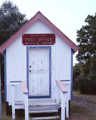
Salvo is a census-designated place located in Dare County, North Carolina, United States, on Hatteras Island, part of North Carolina's Outer Banks. As of the 2010 census, Salvo had a population of 229. Originally part of the settlement of Chicamacomico, Salvo was originally known as "Clarks" or "Clarksville."

<span class="mw-page-title-main">Buxton, North Carolina</span> Census-designated place in North Carolina, United States of America

Buxton is an unincorporated community and census-designated place (CDP) on Hatteras Island near Cape Hatteras. It is located in Dare County in the U.S. state of North Carolina. As of the 2010 census, it had a population of 1,273. Located at the widest part of Hatteras Island, it is the largest community on Hatteras Island both in terms of area and population, and is home to the island's schools and other major public buildings and offices.

<span class="mw-page-title-main">Frisco, North Carolina</span> Census-designated place in North Carolina, United States of America

Frisco is a small unincorporated community and census-designated place (CDP) on the barrier island of Hatteras Island, between the villages of Buxton and Hatteras. It is located in Dare County, North Carolina, United States, and was previously named "Trent", or "Trent Woods", but received a new name with the coming of the post office in 1898. Most of the land is taken by houses available for rental during the summer months, and as such the community's population varies seasonally. As of the 2010 census, the permanent population of the community was 200. North Carolina Highway 12 serves as the primary road in Frisco and connects the community to others on the island.

<span class="mw-page-title-main">Outer Banks</span> Barrier islands in North Carolina, United States

The Outer Banks are a 200 mi (320 km) string of barrier islands and spits off the coast of North Carolina and southeastern Virginia, on the east coast of the United States. They line most of the North Carolina coastline, separating Currituck Sound, Albemarle Sound, and Pamlico Sound from the Atlantic Ocean. A major tourist destination, the Outer Banks are known for their wide expanse of open beachfront and the Cape Hatteras National Seashore. The seashore and surrounding ecosystem are important biodiversity zones, including beach grasses and shrubland that help maintain the form of the land.

<span class="mw-page-title-main">Hartsel, Colorado</span> Census-designated place in Park County, Colorado, United States

Hartsel is a census-designated place (CDP) in and governed by Park County, Colorado United States. The population was 38 at the 2020 census. The Hartsel post office has the ZIP Code 80449. The CDP is a part of the Denver–Aurora–Lakewood, CO Metropolitan Statistical Area.

<span class="mw-page-title-main">Carova Beach, North Carolina</span> Unincorporated community in North Carolina, US

Carova Beach or Carova is an unincorporated community in Currituck County in the extreme northeastern corner of North Carolina, United States. The community, begun in the 1960s, is found on Currituck Banks, north of Bodie Island, and can be accessed only by boat or by four-wheel drive vehicle. There are no paved roads connecting Carova to the town of Corolla, North Carolina. The neighboring settlement of Sandbridge in Virginia Beach, Virginia, is not accessible by vehicle from Carova. In the 1960s, when development began in Carova, there were plans to construct a paved road from Sandbridge south to Carova through the Back Bay National Wildlife Refuge, but these never materialized. Today, there is a permanent fence from ocean to sound to keep vehicles from crossing and, more importantly, to keep the wild horses from migrating to the Virginia side of the border. To reach Carova, four-wheel drive vehicles must drive north along the beach from Corolla into the community, as access from Virginia is limited to pedestrians and bicyclists.

<span class="mw-page-title-main">Currituck National Wildlife Refuge</span> National Wildlife Refuge in North Carolina, United States

Currituck National Wildlife Refuge, located on the northern end of North Carolina's Outer Banks, was established in 1984 to preserve and protect the coastal barrier island ecosystem. Refuge lands are managed to provide wintering habitat for waterfowl and to protect endangered species such as piping plover, sea turtles, and seabeach amaranth.

Caffeys Inlet Lifesaving Station is a historic lifesaving station located near Duck, Dare County, North Carolina. It was built in 1897-1898 by the United States Life-Saving Service near the location of Caffey's Inlet, a historic inlet that opened in 1770 and closed in 1811. It is a two-story, Shingle Style rectangular frame building with a hipped roof lookout tower. It has hip roofed porches connected by a shed roof porch. It was one of seven lifesaving stations established on the Outer Banks of North Carolina in 1874, to serve the ships that were lost in the treacherous waters off the North Carolina coast.

References

  1. 1 2 "Duck". Geographic Names Information System . United States Geological Survey, United States Department of the Interior. June 17, 1980. Retrieved January 4, 2021.
  2. "ArcGIS REST Services Directory". United States Census Bureau. Retrieved September 20, 2022.
  3. "Town of Duck". Geographic Names Information System . United States Geological Survey, United States Department of the Interior. March 10, 2008. Retrieved January 4, 2021.
  4. 1 2 Bureau, US Census. "City and Town Population Totals: 2020-2021". Census.gov. US Census Bureau. Retrieved July 9, 2022.
  5. "Census of Population and Housing". Census.gov. Retrieved June 4, 2016.
  6. "Duck". Stan White Realty and Construction. Retrieved August 14, 2017.
  7. Outerbanks SEO (2012). Town of Duck North Carolina. p. 4.
  8. "Explore Census Data". data.census.gov. Retrieved December 21, 2021.
  9. "Town Park & Boardwalk". Town of Duck. Retrieved November 20, 2015.
  10. Ferguson, J. (n.d.). Town council. Retrieved from http://www.townofduck.com/
  11. "National Register Information System  Caffeys Inlet Lifesaving Station (#78001942)". National Register of Historic Places . National Park Service. November 2, 2013. Retrieved January 4, 2021.
  12. Bleiberg, Larry; McMillan, Libby; Schrandt, Lydia (2015). "Best Coastal Small Town". USA Today . Retrieved February 3, 2016.
  13. "North Carolina 2012 USDA Hardiness Zone Map". Plant Maps. USDA. Retrieved February 1, 2021.
  14. "Water Temperature Table of All Coastal Regions" . Retrieved August 6, 2019.
  15. "U.S. Potential Natural Vegetation, Original Kuchler Types, v2.0 (Spatially Adjusted to Correct Geometric Distortions)" . Retrieved August 6, 2019.
  16. "Attendance Zone Information". Dare County Schools . Retrieved April 12, 2021. Kitty Hawk Elementary School -- Area north of Cameron Street[...]First Flight Middle School/First Flight High School -- All areas north of Nags Head/Kill Devil Hills Town Line - North Beaches Elementary Schools map
  17. Freeman, Darren (August 18, 2004). "NO LINES, NO CROWDS, JUST MORE SPACE". The Virginian-Pilot. Archived from the original on September 11, 2004. Retrieved October 25, 2009. - Entry at NewsBank
Preceded by Beaches of The Outer Banks Succeeded by